
Kalwarya Zebrzydowska (Poland) by Georg Braun & Frans Hogenberg. c. 1625
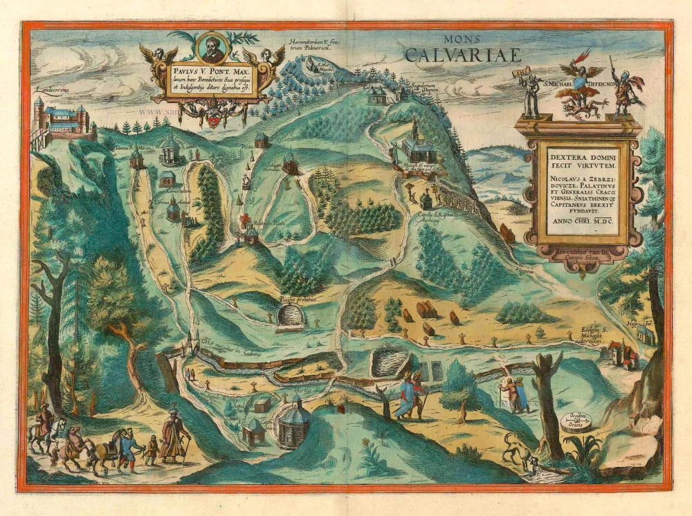


CARTOUCHE LEFT: Pope Paul V found this place worthy of his blessing and rich favours.
CARTOUCHE RIGHT: The right hand of the Lort hath wrought strength - We have found it in the fields of the wood (Psalm 131). Nicolaus Zebrzidovics, Count and General in Cracow, built it in the year 1600.
COMMENTARY BY BRAUN (on verso)): "How much more praiseworthy are they who have a deep desire to see the places where our Lord and saviour died for our salvation. But since not everyone can visit those places personally and see them with their own eyes, that noble hero Mr Mikolaj Zebrzydowski of Zebrzidovicz discovered a place about four miles away from Cracow and found that it matched in almost every way the Hill of Calvary in the Holy Land and other nearby places. He then had it divided and drawn up so that the most important stations of the bitter Passion and death of Christ, as well as other stories mentioned in the Holy Scriptures, could be imagined at the corresponding places [...], just as if one were in Jerusalem."
This panoramic view from the north shows pilgrims on their way to Kalwaria Zebrzydowska, a famous place of pilgrimage southwest of Cracow. In the years 1600-1604, Mikolaj Zebrzydowski, the Voivode of Cracow, inspired by the descriptions of Jerusalem by Christian Adrian Cruys, ordered the reconstruction and renaming of the region around Mount Zarek, modelled as accurately as possible on the actual topography of Jerusalem, even in respect of correct distances. Hills were renamed as the Mount of Olives and Golgotha, and the nearby river rechristened as the Kidron, which flowed through a valley of the same name. The stations visited by pilgrims when following the Passion of Christ were copies of holy places in Jerusalem, with names such as Our Lady's House, Last Supper Room, Caiaphas's House, Herod's Palace or Christ's Sepulchre. Today famous passion plays are performed here during Holy Week, attracting hundreds of thousands of spectators.
Braun G. & Hogenberg F. and the Civitates Orbis Terrarum.
The Civitates Orbis Terrarum, or the "Braun & Hogenberg", is a six-volume town atlas and the most excellent book of town views and plans ever published: 363 engravings, sometimes beautifully coloured. It was one of the best-selling works in the last quarter of the 16th century. Georg Braun wrote the text accompanying the plans and views on the verso. Many plates were engraved after the original drawings of a professional artist, a professional artist, Joris Hoefnagel (1542-1600). The first volume was published in Latin in 1572, and the sixth in 1617. Frans Hogenberg created the tables for volumes I through IV, and Simon van den Neuwel made those for volumes V and VI. Other contributors were cartographers Daniel Freese and Heinrich Rantzau. Works by Jacob van Deventer, Sebastian Münster, and Johannes Stumpf were also used. Translations appeared in German and French.
Following the original publication of Volume 1 of the Civitates in 1572, seven further editions of 1575, 1577, 1582, 1588, 1593, 1599 and 1612 can be identified. Vol.2, first issued in 1575, was followed by further editions in 1597 and 1612. The subsequent volumes appeared in 1581, 1588, 1593, 1599 and 1606. The German translation of the first volume appeared from 1574 on, and the French edition from 1575 on.
Several printers were involved: Theodor Graminaeus, Heinrich von Aich, Gottfried von Kempen, Johannis Sinniger, Bertram Buchholtz and Peter von Brachel, who all worked in Cologne.
Georg Braun (1541-1622)
Georg Braun was born in Cologne in 1541. After his studies in Cologne, he entered the Jesuit Order as a novice. 1561, he obtained his bachelor's degree, and in 1562, he received his Magister Artium. Although he left the Jesuit Order, he studied theology, gaining a licentiate in theology.
Frans Hogenberg (1535-1590)
Frans Hogenberg was a Flemish and German painter, engraver, and mapmaker. He was born in Mechelen as the son of Nicolaas Hogenberg.
By the end of the 1560s, Frans Hogenberg was employed upon Abraham Ortelius's Theatrum Orbis Terrarum, published in 1570; he is named an engraver of numerous maps. In 1568, he was banned from Antwerp by the Duke of Alva and travelled to London, where he stayed a few years before emigrating to Cologne. He immediately embarked on his two most important works, the Civitates, published in 1572 and the Geschichtsblätter, which appeared in several series from 1569 until about 1587.
Thanks to large-scale projects like the Geschichtsblätter and the Civitates, Hogenberg's social circumstances improved with each passing year. He died as a wealthy man in Cologne in 1590.
Mons Calvariae.
Item Number: 10510 Authenticity Guarantee
Category: Antique maps > Europe > Eastern Europe
Antique map - View of Kalwarya Zebrzydowska (southeast of Krakow) by Braun and Hogenberg.
Title: Mons Calvariae.
Date of the first edition: 1617.
Date of this map: c. 1625.
Copper engraving, printed on paper.
Map size: 330 x 455mm (12.99 x 17.91 inches).
Sheet size: 410 x 545mm (16.14 x 21.46 inches).
Verso: French text.
Condition: Original coloured, excellent.
Condition Rating: A+.
References: Van der Krogt 4, #2015, Taschen, Br. Hog., p.481; Fauser, #6346
From: Théatre des Principales Villes de tout l'Univers Vol. VI. c. 1625. (Van der Krogt 4, 41:3.6)
CARTOUCHE LEFT: Pope Paul V found this place worthy of his blessing and rich favours.
CARTOUCHE RIGHT: The right hand of the Lort hath wrought strength - We have found it in the fields of the wood (Psalm 131). Nicolaus Zebrzidovics, Count and General in Cracow, built it in the year 1600.
COMMENTARY BY BRAUN (on verso)): "How much more praiseworthy are they who have a deep desire to see the places where our Lord and saviour died for our salvation. But since not everyone can visit those places personally and see them with their own eyes, that noble hero Mr Mikolaj Zebrzydowski of Zebrzidovicz discovered a place about four miles away from Cracow and found that it matched in almost every way the Hill of Calvary in the Holy Land and other nearby places. He then had it divided and drawn up so that the most important stations of the bitter Passion and death of Christ, as well as other stories mentioned in the Holy Scriptures, could be imagined at the corresponding places [...], just as if one were in Jerusalem."
This panoramic view from the north shows pilgrims on their way to Kalwaria Zebrzydowska, a famous place of pilgrimage southwest of Cracow. In the years 1600-1604, Mikolaj Zebrzydowski, the Voivode of Cracow, inspired by the descriptions of Jerusalem by Christian Adrian Cruys, ordered the reconstruction and renaming of the region around Mount Zarek, modelled as accurately as possible on the actual topography of Jerusalem, even in respect of correct distances. Hills were renamed as the Mount of Olives and Golgotha, and the nearby river rechristened as the Kidron, which flowed through a valley of the same name. The stations visited by pilgrims when following the Passion of Christ were copies of holy places in Jerusalem, with names such as Our Lady's House, Last Supper Room, Caiaphas's House, Herod's Palace or Christ's Sepulchre. Today famous passion plays are performed here during Holy Week, attracting hundreds of thousands of spectators.
Braun G. & Hogenberg F. and the Civitates Orbis Terrarum.
The Civitates Orbis Terrarum, or the "Braun & Hogenberg", is a six-volume town atlas and the most excellent book of town views and plans ever published: 363 engravings, sometimes beautifully coloured. It was one of the best-selling works in the last quarter of the 16th century. Georg Braun wrote the text accompanying the plans and views on the verso. Many plates were engraved after the original drawings of a professional artist, a professional artist, Joris Hoefnagel (1542-1600). The first volume was published in Latin in 1572, and the sixth in 1617. Frans Hogenberg created the tables for volumes I through IV, and Simon van den Neuwel made those for volumes V and VI. Other contributors were cartographers Daniel Freese and Heinrich Rantzau. Works by Jacob van Deventer, Sebastian Münster, and Johannes Stumpf were also used. Translations appeared in German and French.
Following the original publication of Volume 1 of the Civitates in 1572, seven further editions of 1575, 1577, 1582, 1588, 1593, 1599 and 1612 can be identified. Vol.2, first issued in 1575, was followed by further editions in 1597 and 1612. The subsequent volumes appeared in 1581, 1588, 1593, 1599 and 1606. The German translation of the first volume appeared from 1574 on, and the French edition from 1575 on.
Several printers were involved: Theodor Graminaeus, Heinrich von Aich, Gottfried von Kempen, Johannis Sinniger, Bertram Buchholtz and Peter von Brachel, who all worked in Cologne.
Georg Braun (1541-1622)
Georg Braun was born in Cologne in 1541. After his studies in Cologne, he entered the Jesuit Order as a novice. 1561, he obtained his bachelor's degree, and in 1562, he received his Magister Artium. Although he left the Jesuit Order, he studied theology, gaining a licentiate in theology.
Frans Hogenberg (1535-1590)
Frans Hogenberg was a Flemish and German painter, engraver, and mapmaker. He was born in Mechelen as the son of Nicolaas Hogenberg.
By the end of the 1560s, Frans Hogenberg was employed upon Abraham Ortelius's Theatrum Orbis Terrarum, published in 1570; he is named an engraver of numerous maps. In 1568, he was banned from Antwerp by the Duke of Alva and travelled to London, where he stayed a few years before emigrating to Cologne. He immediately embarked on his two most important works, the Civitates, published in 1572 and the Geschichtsblätter, which appeared in several series from 1569 until about 1587.
Thanks to large-scale projects like the Geschichtsblätter and the Civitates, Hogenberg's social circumstances improved with each passing year. He died as a wealthy man in Cologne in 1590.