
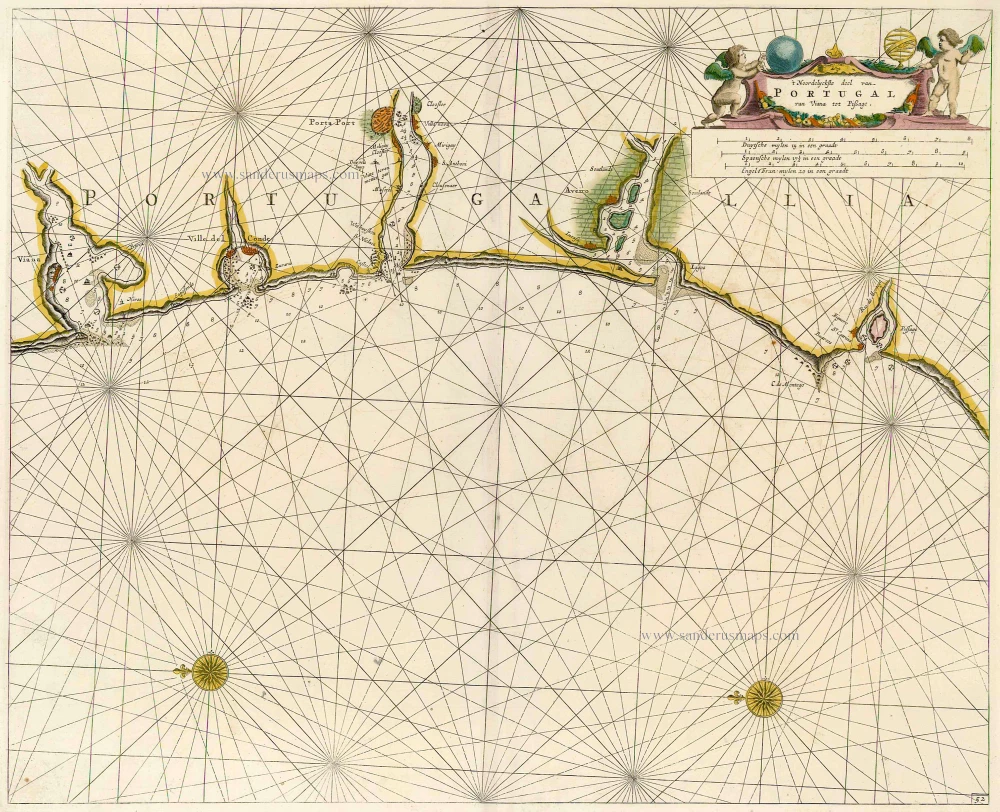
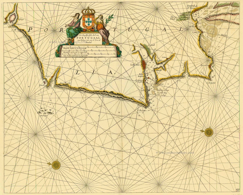
Sea chart of Portugal by Doncker H. 1686
Hendrick Doncker (1625-1699)
Hendrick Doncker became a member of the bookseller's guild in 1647 and ran his shop successfully for fifty years. He was able to develop one of the most popular sets of maritime works published in Amsterdam during the Golden Age.
In 1651 he bought a house in the Nieuwe Brugsteeg in Amsterdam. It was called 'in 't Stuurmans gereetschap' (in the mariners' instruments) and stood opposite the house where Johannes van Keulen later settled.
Apart from the sea atlases, charts and pilot books, Hendrik Doncker published various editions of textbooks on the art of navigation.
After the death of Hendrick Doncker, the son, Hendrick II (c. 1664-c.1739), continued publishing the sea atlases Zeeatlas and Zeespiegel until 1708.
Doncker's charts were the most up-to-date in the second half of the 17th century. Although there is some similarity to those charts published by Van Loon, Goos, Lootsman, and Doncker, the latter's charts are original.
In 1655, Hendrick Doncker had begun with the publication of a pilot guide, the Lichtende Columne ofte Zeespiegel. In 1659 he published his first sea atlas, the Zee-Atlas of Waeter-waereld, with 19 maps. Between 1659 and 1669, he increased the number of charts from 19 to 30 and in 1669 he came with an edition containing 50, which was soon to be followed by an edition with large maps: the Nieuwe Groote Vermeerderde Zeeatlas, also with 50 charts. This beautiful atlas was reprinted and continually improved for more than 25 years. After the death of Hendrick Doncker in 1699, his son continued the publication and even enlarged and enhanced the sea-atlas.
't Noordelyckste deel van Portugal van Viana tot Pissage.
Item Number: 15379 Authenticity Guarantee
Category: Antique maps > Europe > Spain and Portugal
Old, antique map of Sea chart of Portugal by Doncker H.
Title: 't Noordelyckste deel van Portugal van Viana tot Pissage.
Date: 1686.
Copper engraving, printed on paper.
Size (not including margins): 412 x 510mm (16.22 x 20.08 inches).
Verso: Blank.
Condition: Original coloured, excellent.
Condition Rating: A+.
From: Le Grand & Nouveau Miroir ou Flambeau, De la Mer contenant la description de toutes les costes Marines Occidentalled & Septentrionalles, . . . Traduit de Flaman en François par Paul Yvounet. A Amsterdam Chés Henri Donker, . . . l'An 1686.
Hendrick Doncker (1625-1699)
Hendrick Doncker became a member of the bookseller's guild in 1647 and ran his shop successfully for fifty years. He was able to develop one of the most popular sets of maritime works published in Amsterdam during the Golden Age.
In 1651 he bought a house in the Nieuwe Brugsteeg in Amsterdam. It was called 'in 't Stuurmans gereetschap' (in the mariners' instruments) and stood opposite the house where Johannes van Keulen later settled.
Apart from the sea atlases, charts and pilot books, Hendrik Doncker published various editions of textbooks on the art of navigation.
After the death of Hendrick Doncker, the son, Hendrick II (c. 1664-c.1739), continued publishing the sea atlases Zeeatlas and Zeespiegel until 1708.
Doncker's charts were the most up-to-date in the second half of the 17th century. Although there is some similarity to those charts published by Van Loon, Goos, Lootsman, and Doncker, the latter's charts are original.
In 1655, Hendrick Doncker had begun with the publication of a pilot guide, the Lichtende Columne ofte Zeespiegel. In 1659 he published his first sea atlas, the Zee-Atlas of Waeter-waereld, with 19 maps. Between 1659 and 1669, he increased the number of charts from 19 to 30 and in 1669 he came with an edition containing 50, which was soon to be followed by an edition with large maps: the Nieuwe Groote Vermeerderde Zeeatlas, also with 50 charts. This beautiful atlas was reprinted and continually improved for more than 25 years. After the death of Hendrick Doncker in 1699, his son continued the publication and even enlarged and enhanced the sea-atlas.
Related items
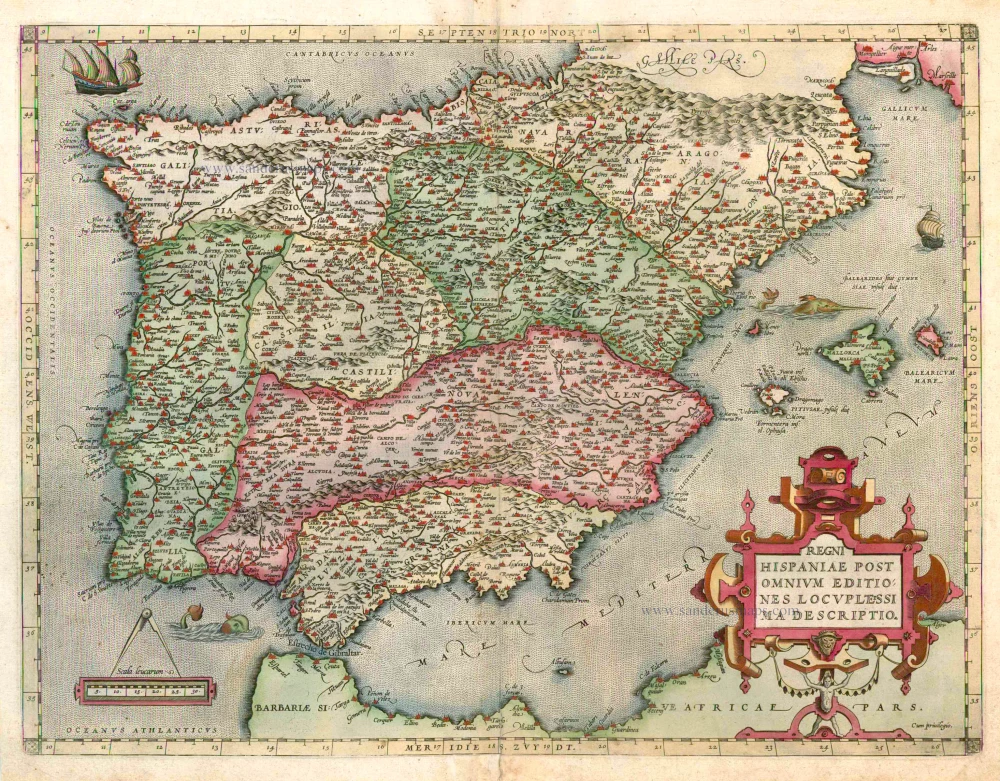
Regni Hispaniae Post Omnium Editiones Locuplessima Descriptio. 1598
Iberian Peninsula (Portugal & Spain), by Abraham Ortelius.
[Item number: 2568]
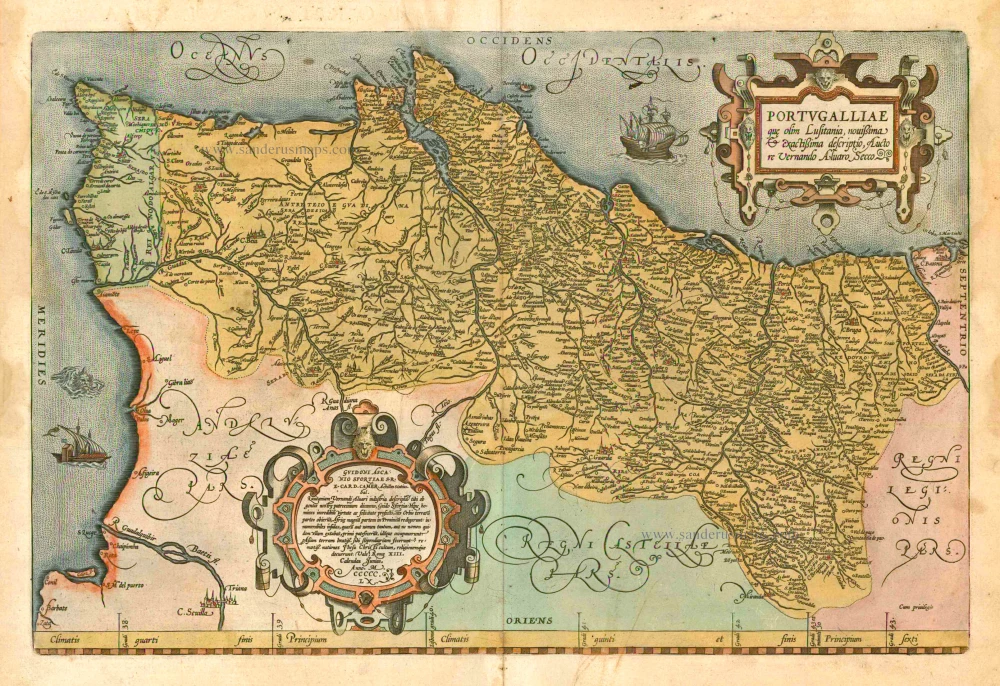
Portugalliae que olim Lusitania, novissima & exactissima descriptio, ... 1601
Portugal by A. Ortelius.
[Item number: 5729]
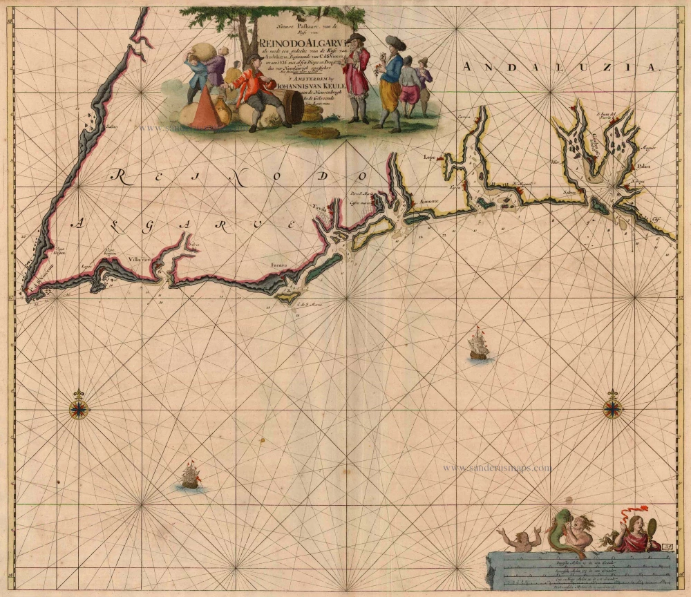
Nieuwe Paskaart, van de Kust van Reino do Algarve als mede een gedeelte van de Kust van Andaluzia. Beginnende vn C. d. S. Vincent tot aen 't Klif, ... 1697-1709
Algarve, by Johannes Van Keulen.
[Item number: 5805]
Very rare!
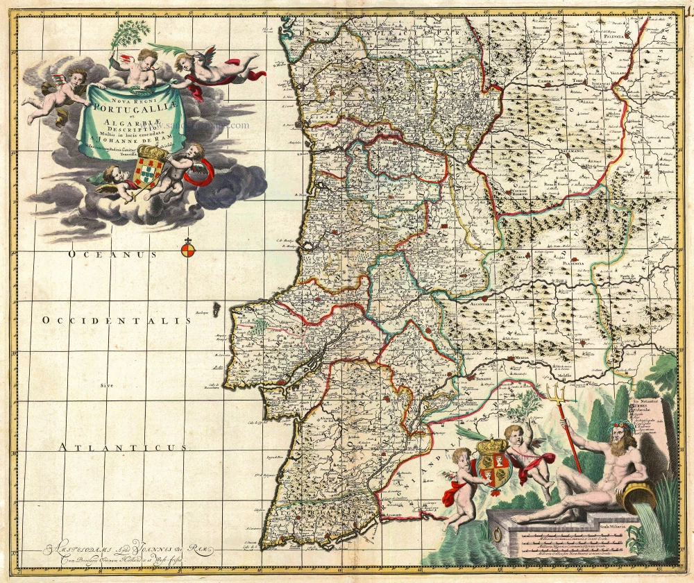
Nova Regni Portugalliae et Algarbiae Descriptio ... c. 1690
Portugal by J. de Ram, published by F. De Wit.
[Item number: 13745]
Het Zuydlyckste deel van Portugaal van Pissage tot aen S. Uves al: Setubal. 1686
Sea chart of Portugal by Doncker H.
[Item number: 16192]
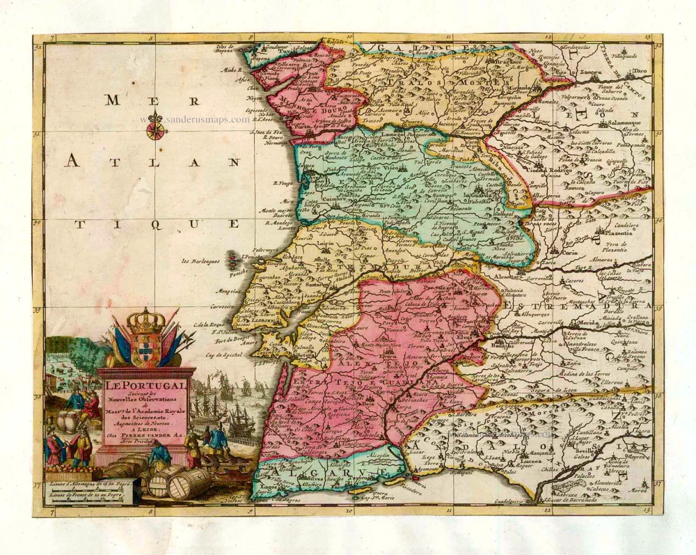
Le Portugal. 1713
Portugal, by Pieter van der Aa.
[Item number: 26086]
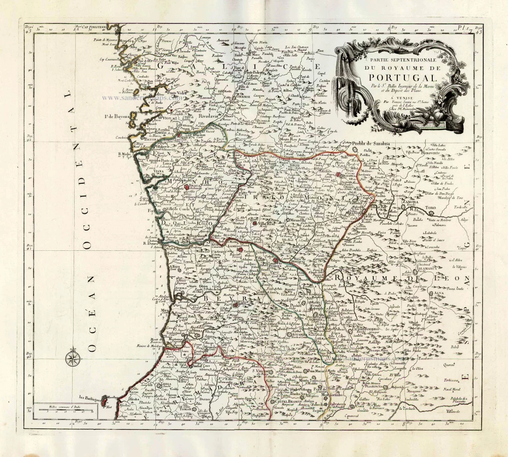
Partie Septentrionale du Royaume de Portugal. 1776-79
Northern Portugal, by Francesco Santini.
[Item number: 26951]
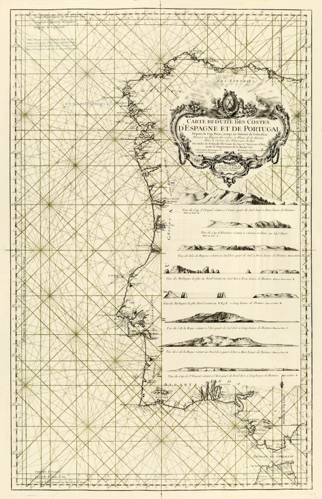
Carte Réduite des Costes d'Espagne et de Portugal. 1756-1770
Spain - Portugal, by J.N. Bellin.
[Item number: 28124]
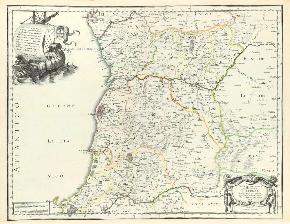
Parte Septentrional do Reyno de Portugal. 1658
Northern Portugal by Nicolas Sanson.
[Item number: 29663]
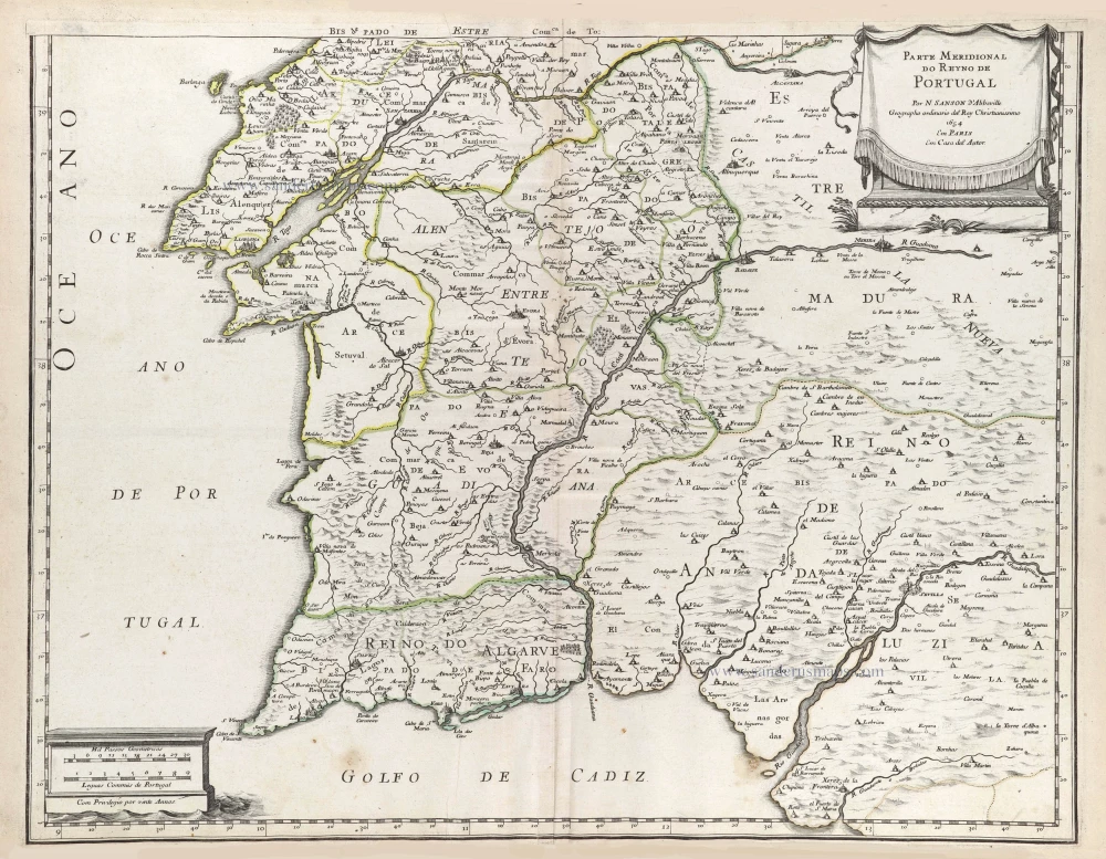
Parte Septentrional do Reyno de Portugal. 1658
Southern Portugal by Nicolas Sanson.
[Item number: 29664]
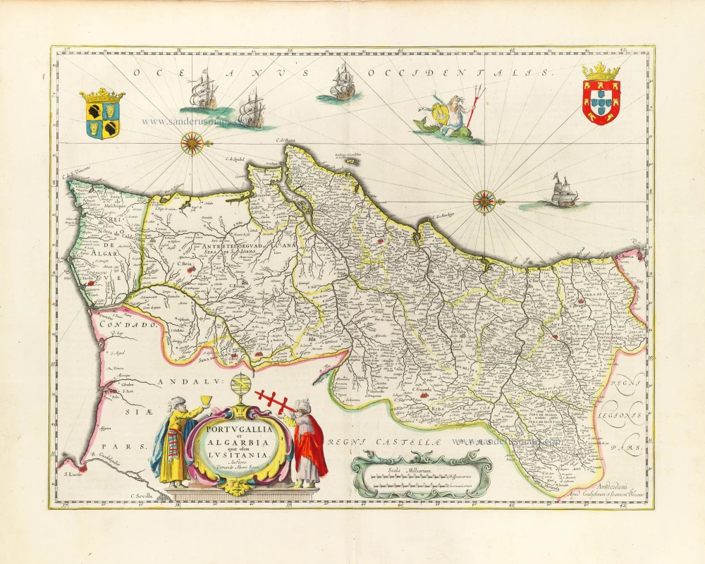
Portugallia et Algarbia quae olim Lusitania. 1643
Portugal, by Willem & Joan Blaeu.
[Item number: 30529]
new