
Louny and Slany in Bohemia, by Georg Braun and Frans Hogenberg. c. 1625
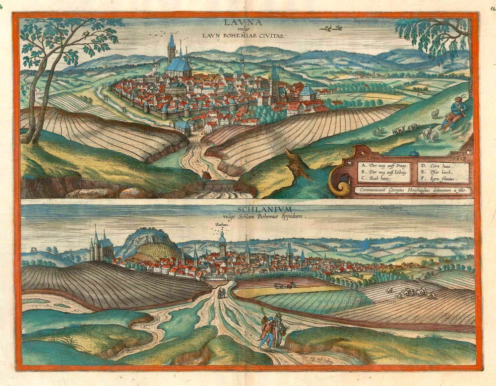


LOUNY
CAPTION: Launa, in German Laun, a town in Bohemia.
CARTOUCHE: Procured by Georg Hoefnagel, drawn by his son.
COMMENTARY BY BRAUN (on verso): "*The Taborites also appreciated the beautiful situation of this town, and therefore took it for themselves. In his 24th book Johannes Dubravius writes something that is on the one hand amusing, but on the other hand sad, namely that the Taborites believe that when the Day of Judgement comes, terrors await the wicked and the godless, and delights the pious, among which they count themselves. But not even the pious will be redeemed unless they live in one of the following five towns, namely Plzen, Louny, Lany, Klatovy and Zatec*." This view from the southeast from a slightly elevated viewpoint shows the well-fortified north Bohemian town situated close to the River Ohre (F). Louny is dominated by three large buildings: the gatetower on the right; the church of St Nicholas (E) with its 14th-century bell tower and late Gothic nave that was rebuilt by Benedikt Ried from 1520 to 1538 after the town was destroyed by fire; and the town hall (C) between these two buildings. Located at a junction of trade routes, Louny was first recorded in the 11th century. It became a stronghold of the Taborites, a radical wing of the Hussites, who sought to build the Kingdom of God by armed force.
SLANY
CAPTION: Schlanium, in the vernacular Slany, a town in Bohemia.
COMMENTARY BY BRAUN (on verso): "*Slany lies almost halfway between Louny and Prague and is a handsome and elegant town. Dubravius writes in his 2nd book that it got its name from sal, which means salt, in the following manner. ... When peace reigned throughout the empire, the hope of a stroke of good fortune and a tolerable mode of life was fulfilled by the discovery of several salt veins, which are common in Bohemia but are not found in other countries, so that a large number of people soon settled here to boil and process the salt, and the town of Slany was built in a very short time.*" The town is presented from the north from a slightly elevated position. It is dominated by the hill from which it takes its name, which can be seen on the left, and to the left of that church of the holy Trinity. The tower of the town hall stands out clearly in the middle. Slany Hill was settled in Neolithic times, and the salt springs that were discovered here in the 8th century led to the foundation of the town around 1300. In the following centuries it was granted many privileges and developed into an important commercial centre. (Taschen)
Braun G. & Hogenberg F. and the Civitates Orbis Terrarum.
The Civitates Orbis Terrarum, or the "Braun & Hogenberg", is a six-volume town atlas and the most excellent book of town views and plans ever published: 363 engravings, sometimes beautifully coloured. It was one of the best-selling works in the last quarter of the 16th century. Georg Braun wrote the text accompanying the plans and views on the verso. Many plates were engraved after the original drawings of a professional artist, a professional artist, Joris Hoefnagel (1542-1600). The first volume was published in Latin in 1572, and the sixth in 1617. Frans Hogenberg created the tables for volumes I through IV, and Simon van den Neuwel made those for volumes V and VI. Other contributors were cartographers Daniel Freese and Heinrich Rantzau. Works by Jacob van Deventer, Sebastian Münster, and Johannes Stumpf were also used. Translations appeared in German and French.
Following the original publication of Volume 1 of the Civitates in 1572, seven further editions of 1575, 1577, 1582, 1588, 1593, 1599 and 1612 can be identified. Vol.2, first issued in 1575, was followed by further editions in 1597 and 1612. The subsequent volumes appeared in 1581, 1588, 1593, 1599 and 1606. The German translation of the first volume appeared from 1574 on, and the French edition from 1575 on.
Several printers were involved: Theodor Graminaeus, Heinrich von Aich, Gottfried von Kempen, Johannis Sinniger, Bertram Buchholtz and Peter von Brachel, who all worked in Cologne.
Georg Braun (1541-1622)
Georg Braun was born in Cologne in 1541. After his studies in Cologne, he entered the Jesuit Order as a novice. 1561, he obtained his bachelor's degree, and in 1562, he received his Magister Artium. Although he left the Jesuit Order, he studied theology, gaining a licentiate in theology.
Frans Hogenberg (1535-1590)
Frans Hogenberg was a Flemish and German painter, engraver, and mapmaker. He was born in Mechelen as the son of Nicolaas Hogenberg.
By the end of the 1560s, Frans Hogenberg was employed upon Abraham Ortelius's Theatrum Orbis Terrarum, published in 1570; he is named an engraver of numerous maps. In 1568, he was banned from Antwerp by the Duke of Alva and travelled to London, where he stayed a few years before emigrating to Cologne. He immediately embarked on his two most important works, the Civitates, published in 1572 and the Geschichtsblätter, which appeared in several series from 1569 until about 1587.
Thanks to large-scale projects like the Geschichtsblätter and the Civitates, Hogenberg's social circumstances improved with each passing year. He died as a wealthy man in Cologne in 1590.
Launa vulgo Laun Bohemiae Civitas [on sheet with] Schlanium vulgo Schlani Bohemiae oppidum.
Item Number: 16414 Authenticity Guarantee
Category: Antique maps > Europe > Central Europe
Old, antique bird’s-eye view plan of Louny and Slany in Bohemia, by Georg Braun and Frans Hogenberg.
Title: Launa vulgo Laun Bohemiae Civitas [on sheet with] Schlanium vulgo Schlani Bohemiae oppidum.
Date of the first edition: 1617.
Date of this map: c. 1625.
Copper engraving, printed on paper.
Size (not including margins): 366 x 480mm (14.41 x 18.9 inches).
Verso: French text.
Condition: Original coloured, excellent.
Condition Rating: A+.
From: Théatre des Principales Villes de tout l'Univers Vol. VI. c. 1625. (Van der Krogt 4, 41:3.6)
LOUNY
CAPTION: Launa, in German Laun, a town in Bohemia.
CARTOUCHE: Procured by Georg Hoefnagel, drawn by his son.
COMMENTARY BY BRAUN (on verso): "*The Taborites also appreciated the beautiful situation of this town, and therefore took it for themselves. In his 24th book Johannes Dubravius writes something that is on the one hand amusing, but on the other hand sad, namely that the Taborites believe that when the Day of Judgement comes, terrors await the wicked and the godless, and delights the pious, among which they count themselves. But not even the pious will be redeemed unless they live in one of the following five towns, namely Plzen, Louny, Lany, Klatovy and Zatec*." This view from the southeast from a slightly elevated viewpoint shows the well-fortified north Bohemian town situated close to the River Ohre (F). Louny is dominated by three large buildings: the gatetower on the right; the church of St Nicholas (E) with its 14th-century bell tower and late Gothic nave that was rebuilt by Benedikt Ried from 1520 to 1538 after the town was destroyed by fire; and the town hall (C) between these two buildings. Located at a junction of trade routes, Louny was first recorded in the 11th century. It became a stronghold of the Taborites, a radical wing of the Hussites, who sought to build the Kingdom of God by armed force.
SLANY
CAPTION: Schlanium, in the vernacular Slany, a town in Bohemia.
COMMENTARY BY BRAUN (on verso): "*Slany lies almost halfway between Louny and Prague and is a handsome and elegant town. Dubravius writes in his 2nd book that it got its name from sal, which means salt, in the following manner. ... When peace reigned throughout the empire, the hope of a stroke of good fortune and a tolerable mode of life was fulfilled by the discovery of several salt veins, which are common in Bohemia but are not found in other countries, so that a large number of people soon settled here to boil and process the salt, and the town of Slany was built in a very short time.*" The town is presented from the north from a slightly elevated position. It is dominated by the hill from which it takes its name, which can be seen on the left, and to the left of that church of the holy Trinity. The tower of the town hall stands out clearly in the middle. Slany Hill was settled in Neolithic times, and the salt springs that were discovered here in the 8th century led to the foundation of the town around 1300. In the following centuries it was granted many privileges and developed into an important commercial centre. (Taschen)
Braun G. & Hogenberg F. and the Civitates Orbis Terrarum.
The Civitates Orbis Terrarum, or the "Braun & Hogenberg", is a six-volume town atlas and the most excellent book of town views and plans ever published: 363 engravings, sometimes beautifully coloured. It was one of the best-selling works in the last quarter of the 16th century. Georg Braun wrote the text accompanying the plans and views on the verso. Many plates were engraved after the original drawings of a professional artist, a professional artist, Joris Hoefnagel (1542-1600). The first volume was published in Latin in 1572, and the sixth in 1617. Frans Hogenberg created the tables for volumes I through IV, and Simon van den Neuwel made those for volumes V and VI. Other contributors were cartographers Daniel Freese and Heinrich Rantzau. Works by Jacob van Deventer, Sebastian Münster, and Johannes Stumpf were also used. Translations appeared in German and French.
Following the original publication of Volume 1 of the Civitates in 1572, seven further editions of 1575, 1577, 1582, 1588, 1593, 1599 and 1612 can be identified. Vol.2, first issued in 1575, was followed by further editions in 1597 and 1612. The subsequent volumes appeared in 1581, 1588, 1593, 1599 and 1606. The German translation of the first volume appeared from 1574 on, and the French edition from 1575 on.
Several printers were involved: Theodor Graminaeus, Heinrich von Aich, Gottfried von Kempen, Johannis Sinniger, Bertram Buchholtz and Peter von Brachel, who all worked in Cologne.
Georg Braun (1541-1622)
Georg Braun was born in Cologne in 1541. After his studies in Cologne, he entered the Jesuit Order as a novice. 1561, he obtained his bachelor's degree, and in 1562, he received his Magister Artium. Although he left the Jesuit Order, he studied theology, gaining a licentiate in theology.
Frans Hogenberg (1535-1590)
Frans Hogenberg was a Flemish and German painter, engraver, and mapmaker. He was born in Mechelen as the son of Nicolaas Hogenberg.
By the end of the 1560s, Frans Hogenberg was employed upon Abraham Ortelius's Theatrum Orbis Terrarum, published in 1570; he is named an engraver of numerous maps. In 1568, he was banned from Antwerp by the Duke of Alva and travelled to London, where he stayed a few years before emigrating to Cologne. He immediately embarked on his two most important works, the Civitates, published in 1572 and the Geschichtsblätter, which appeared in several series from 1569 until about 1587.
Thanks to large-scale projects like the Geschichtsblätter and the Civitates, Hogenberg's social circumstances improved with each passing year. He died as a wealthy man in Cologne in 1590.