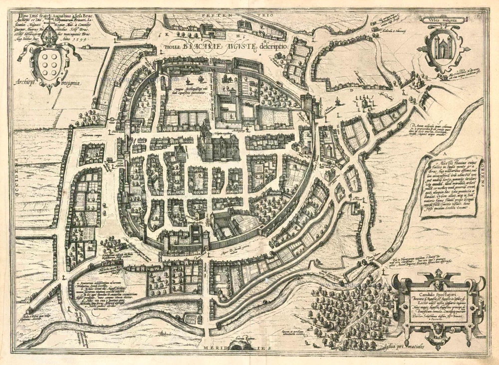
Braga, by Georg Braun and Frans Hogenberg. 1600
The item displayed on this page has been sold. However, we have a similar map in stock:
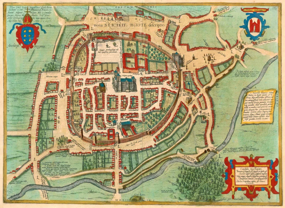
Braga, by Georg Braun and Frans Hogenberg. 1596
Nova Bracarae Auguste Descriptio.
[Item number: 24134]

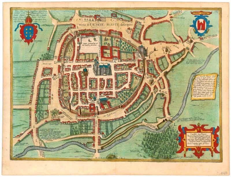


TRANSLATION OF CAPTION TOP LEFT: Gaspar Alvarus Machiadus, historian of the Holy Church of Braga, named the city after the famous lord, the Augustinian friar à Jesu Brac[ara], archbishop and lord, primate of Spain, magnate of Lusitania, counsellor at the royal court. 13 August 1594.
CAPTION RIGHT CENTRE: The River Alestes, which has its source in the Spino Mountains four miles from Braga, irrigates a delightful valley adjacent to the city, where many orchards and gardens have been planted. It is extraordinary that no lemon trees grow here, abundant everywhere else in the whole province. The river runs past the city and flows into the Avurus, which some wrongly call the Sethen, near the ancient town of Villa Comitis.
COMMENTARY BY BRAUN: "Braga is considered one of the oldest cities on the Iberian Peninsula and was built in 290 BC. [...] Alfonso I, the Catholic, wrested Braga from the tyrannous rule of the Moors before the other cities of Spain and, in AD 740, gave it back its former freedom. Count Henry also lies buried here in a most exquisite church that he himself had built. He was the father of Alfonso the Conqueror, the first king of Portugal."
Braga, which lies northeast of Porto on the Cávado River, is presented in a bird's-eye view from the south. The area was originally inhabited by the Bracari, a Celtic tribe, before being conquered in the 3rd century BC by the Romans, who founded the settlement of Bracara Augusta a few years before the birth of Christ. At the start of the 12th century, Braga was elevated to an archbishopric by Henry of Burgundy after a chequered history. As Count of Portugal, Henry freed his territory from growing dependence upon Castile. His son Alfonso I, the Conqueror, continued in this direction and, in 1139, declared himself the first king of Portugal. The creation of the see in 1107 also marked the start of the construction of the cathedral, illustrated at the centre of the city. (Taschen)
Braun G. & Hogenberg F. and the Civitates Orbis Terrarum.
The Civitates Orbis Terrarum, or the "Braun & Hogenberg", is a six-volume town atlas and the most excellent book of town views and plans ever published: 363 engravings, sometimes beautifully coloured. It was one of the best-selling works in the last quarter of the 16th century. Georg Braun wrote the text accompanying the plans and views on the verso. Many plates were engraved after the original drawings of a professional artist, a professional artist, Joris Hoefnagel (1542-1600). The first volume was published in Latin in 1572, and the sixth in 1617. Frans Hogenberg created the tables for volumes I through IV, and Simon van den Neuwel made those for volumes V and VI. Other contributors were cartographers Daniel Freese and Heinrich Rantzau. Works by Jacob van Deventer, Sebastian Münster, and Johannes Stumpf were also used. Translations appeared in German and French.
Following the original publication of Volume 1 of the Civitates in 1572, seven further editions of 1575, 1577, 1582, 1588, 1593, 1599 and 1612 can be identified. Vol.2, first issued in 1575, was followed by further editions in 1597 and 1612. The subsequent volumes appeared in 1581, 1588, 1593, 1599 and 1606. The German translation of the first volume appeared from 1574 on, and the French edition from 1575 on.
Several printers were involved: Theodor Graminaeus, Heinrich von Aich, Gottfried von Kempen, Johannis Sinniger, Bertram Buchholtz and Peter von Brachel, who all worked in Cologne.
Georg Braun (1541-1622)
Georg Braun was born in Cologne in 1541. After his studies in Cologne, he entered the Jesuit Order as a novice. 1561, he obtained his bachelor's degree, and in 1562, he received his Magister Artium. Although he left the Jesuit Order, he studied theology, gaining a licentiate in theology.
Frans Hogenberg (1535-1590)
Frans Hogenberg was a Flemish and German painter, engraver, and mapmaker. He was born in Mechelen as the son of Nicolaas Hogenberg.
By the end of the 1560s, Frans Hogenberg was employed upon Abraham Ortelius's Theatrum Orbis Terrarum, published in 1570; he is named an engraver of numerous maps. In 1568, he was banned from Antwerp by the Duke of Alva and travelled to London, where he stayed a few years before emigrating to Cologne. He immediately embarked on his two most important works, the Civitates, published in 1572 and the Geschichtsblätter, which appeared in several series from 1569 until about 1587.
Thanks to large-scale projects like the Geschichtsblätter and the Civitates, Hogenberg's social circumstances improved with each passing year. He died as a wealthy man in Cologne in 1590.
Nova Bracarae Auguste Descriptio
Item Number: 16484 Authenticity Guarantee
Category: Antique maps > Europe > Spain and Portugal
Braga, by Georg Braun and Frans Hogenberg.
Title: Nova Bracarae Auguste Descriptio
Date of the first edition: 1596.
Date of this map: 1600.
Copper engraving, printed on paper.
Image size: 370 x 500mm (14.57 x 19.69 inches).
Sheet size: 415 x 640mm (16.34 x 25.2 inches).
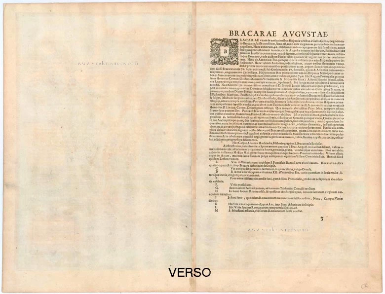
Verso: Latin text.
Condition: Excellent, superb old colour.
Condition Rating: A+.
From: Civitates Orbis Terrarum, ... Part 5. Köln, Bertram Buchholtz, 1600.
TRANSLATION OF CAPTION TOP LEFT: Gaspar Alvarus Machiadus, historian of the Holy Church of Braga, named the city after the famous lord, the Augustinian friar à Jesu Brac[ara], archbishop and lord, primate of Spain, magnate of Lusitania, counsellor at the royal court. 13 August 1594.
CAPTION RIGHT CENTRE: The River Alestes, which has its source in the Spino Mountains four miles from Braga, irrigates a delightful valley adjacent to the city, where many orchards and gardens have been planted. It is extraordinary that no lemon trees grow here, abundant everywhere else in the whole province. The river runs past the city and flows into the Avurus, which some wrongly call the Sethen, near the ancient town of Villa Comitis.
COMMENTARY BY BRAUN: "Braga is considered one of the oldest cities on the Iberian Peninsula and was built in 290 BC. [...] Alfonso I, the Catholic, wrested Braga from the tyrannous rule of the Moors before the other cities of Spain and, in AD 740, gave it back its former freedom. Count Henry also lies buried here in a most exquisite church that he himself had built. He was the father of Alfonso the Conqueror, the first king of Portugal."
Braga, which lies northeast of Porto on the Cávado River, is presented in a bird's-eye view from the south. The area was originally inhabited by the Bracari, a Celtic tribe, before being conquered in the 3rd century BC by the Romans, who founded the settlement of Bracara Augusta a few years before the birth of Christ. At the start of the 12th century, Braga was elevated to an archbishopric by Henry of Burgundy after a chequered history. As Count of Portugal, Henry freed his territory from growing dependence upon Castile. His son Alfonso I, the Conqueror, continued in this direction and, in 1139, declared himself the first king of Portugal. The creation of the see in 1107 also marked the start of the construction of the cathedral, illustrated at the centre of the city. (Taschen)
Braun G. & Hogenberg F. and the Civitates Orbis Terrarum.
The Civitates Orbis Terrarum, or the "Braun & Hogenberg", is a six-volume town atlas and the most excellent book of town views and plans ever published: 363 engravings, sometimes beautifully coloured. It was one of the best-selling works in the last quarter of the 16th century. Georg Braun wrote the text accompanying the plans and views on the verso. Many plates were engraved after the original drawings of a professional artist, a professional artist, Joris Hoefnagel (1542-1600). The first volume was published in Latin in 1572, and the sixth in 1617. Frans Hogenberg created the tables for volumes I through IV, and Simon van den Neuwel made those for volumes V and VI. Other contributors were cartographers Daniel Freese and Heinrich Rantzau. Works by Jacob van Deventer, Sebastian Münster, and Johannes Stumpf were also used. Translations appeared in German and French.
Following the original publication of Volume 1 of the Civitates in 1572, seven further editions of 1575, 1577, 1582, 1588, 1593, 1599 and 1612 can be identified. Vol.2, first issued in 1575, was followed by further editions in 1597 and 1612. The subsequent volumes appeared in 1581, 1588, 1593, 1599 and 1606. The German translation of the first volume appeared from 1574 on, and the French edition from 1575 on.
Several printers were involved: Theodor Graminaeus, Heinrich von Aich, Gottfried von Kempen, Johannis Sinniger, Bertram Buchholtz and Peter von Brachel, who all worked in Cologne.
Georg Braun (1541-1622)
Georg Braun was born in Cologne in 1541. After his studies in Cologne, he entered the Jesuit Order as a novice. 1561, he obtained his bachelor's degree, and in 1562, he received his Magister Artium. Although he left the Jesuit Order, he studied theology, gaining a licentiate in theology.
Frans Hogenberg (1535-1590)
Frans Hogenberg was a Flemish and German painter, engraver, and mapmaker. He was born in Mechelen as the son of Nicolaas Hogenberg.
By the end of the 1560s, Frans Hogenberg was employed upon Abraham Ortelius's Theatrum Orbis Terrarum, published in 1570; he is named an engraver of numerous maps. In 1568, he was banned from Antwerp by the Duke of Alva and travelled to London, where he stayed a few years before emigrating to Cologne. He immediately embarked on his two most important works, the Civitates, published in 1572 and the Geschichtsblätter, which appeared in several series from 1569 until about 1587.
Thanks to large-scale projects like the Geschichtsblätter and the Civitates, Hogenberg's social circumstances improved with each passing year. He died as a wealthy man in Cologne in 1590.