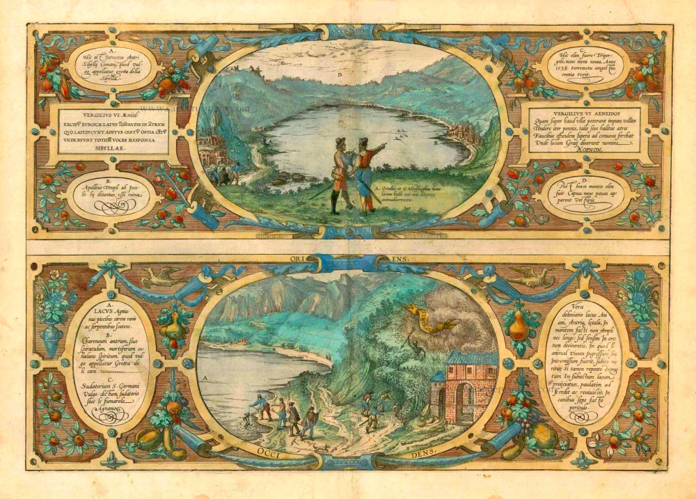
The Grotto of the Cumaean Sibyl - Lake Agnano, by Braun & Hogenberg 1588
THE GROTTO OF THE CUMAEAN SIBYL (L'ANTRO DELLA SIBILLA CUMANA)
COMMENTARY BY BRAUN: "On the way to Lake Averno from Cumae, an exceedingly famous and ancient city in Campania, is Sibyl's grotto. This cave is carved into the rock in a wondrous and unique fashion. It is generally believed that this is where the Sibyl of Cumaea lived."
This is a view of Lake Averno from the east, with the entrance to Sibyl's grotto (A: "Here is the entrance to the Grotto of the Cumaean Sibyl, known as the Grotta della Sibylla in Italian") and the temple of Apollo (B). In the middle, we see Hoefnagel and Ortelius engaged in conversation. The inscription at their feet reveals they are discussing both the etymology of the place name and its ancient context; they are making an empirical examination of the classical texts: The Greek name means "birdless", it could be taken to be the entrance to Hades. Yet Hoefnagel points demonstratively to the five ducks in the middle of the lake, thus refuting claims that Lake Averno was the entrance to the Underworld in this day (information by Stephan Pelgen). Earlier commentators have suggested that Hoefnagel and Ortelius are pointing to the temple of Apollo, thus failing to appreciate the inherent humour of the illustration and its inscriptions.
LAKE AGNANO (LAGO D'AGNANO)
TRANSLATION OF CARTOUCHE RIGHT: A true delineation of Lake Agnano and the deadly cave, which is neither spacious nor does it penetrate deeply into the mountain but slopes gently towards the north. If any living creature enters it or is sent in, it will die at once; but if it is immediately pulled out and thrown into the aforementioned lake, it will slowly recover and come to life again. This is often tried out with dogs.
COMMENTARY BY BRAUN: "Lake Agnano is not far from the city of Pozzuoli, with a broad shore all around it. Near Pozzuoli, there are blow holes, others call them the caves of Charon, which emit a deadly vapour. There is a cave deep in the rock, with a sign next to it warning people not to approach it too closely."
The second view, which is as ornately framed as the first, shows the volcanic Lake Agnano with the Grotta del Cane (Dog's Cave), so called because gases rise constantly from its floor up to a height of about 45 cm, so that a dog, upon entering it, immediately becomes unconscious. The lake was probably first formed in the Middle Ages since it is not mentioned by the authors of classical antiquity; it was drained in 1870. To the right of the lake are the Stufe di San Germano, chambers in which the hot sulphur gases are stored for medicinal purposes. As in the plate of Pozzuoli and Baia, the instructive inscriptions make reference to the discussion between the artist and scholar. (Taschen)
Braun G. & Hogenberg F. and the Civitates Orbis Terrarum.
The Civitates Orbis Terrarum, or the "Braun & Hogenberg", is a six-volume town atlas and the most excellent book of town views and plans ever published: 363 engravings, sometimes beautifully coloured. It was one of the best-selling works in the last quarter of the 16th century. Georg Braun wrote the text accompanying the plans and views on the verso. Many plates were engraved after the original drawings of a professional artist, a professional artist, Joris Hoefnagel (1542-1600). The first volume was published in Latin in 1572, and the sixth in 1617. Frans Hogenberg created the tables for volumes I through IV, and Simon van den Neuwel made those for volumes V and VI. Other contributors were cartographers Daniel Freese and Heinrich Rantzau. Works by Jacob van Deventer, Sebastian Münster, and Johannes Stumpf were also used. Translations appeared in German and French.
Following the original publication of Volume 1 of the Civitates in 1572, seven further editions of 1575, 1577, 1582, 1588, 1593, 1599 and 1612 can be identified. Vol.2, first issued in 1575, was followed by further editions in 1597 and 1612. The subsequent volumes appeared in 1581, 1588, 1593, 1599 and 1606. The German translation of the first volume appeared from 1574 on, and the French edition from 1575 on.
Several printers were involved: Theodor Graminaeus, Heinrich von Aich, Gottfried von Kempen, Johannis Sinniger, Bertram Buchholtz and Peter von Brachel, who all worked in Cologne.
Georg Braun (1541-1622)
Georg Braun was born in Cologne in 1541. After his studies in Cologne, he entered the Jesuit Order as a novice. 1561, he obtained his bachelor's degree, and in 1562, he received his Magister Artium. Although he left the Jesuit Order, he studied theology, gaining a licentiate in theology.
Frans Hogenberg (1535-1590)
Frans Hogenberg was a Flemish and German painter, engraver, and mapmaker. He was born in Mechelen as the son of Nicolaas Hogenberg.
By the end of the 1560s, Frans Hogenberg was employed upon Abraham Ortelius's Theatrum Orbis Terrarum, published in 1570; he is named an engraver of numerous maps. In 1568, he was banned from Antwerp by the Duke of Alva and travelled to London, where he stayed a few years before emigrating to Cologne. He immediately embarked on his two most important works, the Civitates, published in 1572 and the Geschichtsblätter, which appeared in several series from 1569 until about 1587.
Thanks to large-scale projects like the Geschichtsblätter and the Civitates, Hogenberg's social circumstances improved with each passing year. He died as a wealthy man in Cologne in 1590.
Vera deliniatio lacus Aniani, Antriq, letalis, ...
Item Number: 21535 Authenticity Guarantee
Category: Antique maps > Europe > Italy - Cities
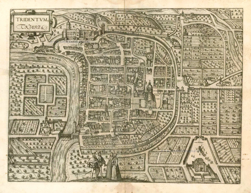
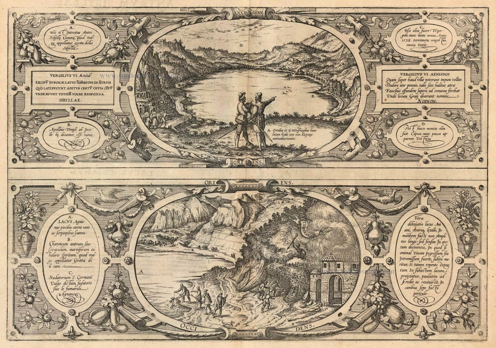
Two views from east and west of Lake Agnano and the extinct city of Cumae, Italy, by Georg Braun and Frans Hogenberg. These views are engraved after drawings by Georg Hoefnagel.
Title: Vera deliniatio lacus Aniani, Antriq, letalis, ...
Date of the first edition: 1581.
Date of this map: 1588.
Copper engraving, printed on paper.
Size (not including margins): 325 x 473mm (12.8 x 18.62 inches).
Verso: Latin text.
Condition: Uncoloured, small repairs at the centre (wormholes reinforced).
Condition Rating: B.
From: Civitates Orbis Terrarum. . Liber tertius. Cologne, Gottfried von Kempen, 1588. (Van der Krogt 4, 41:1.3)
THE GROTTO OF THE CUMAEAN SIBYL (L'ANTRO DELLA SIBILLA CUMANA)
COMMENTARY BY BRAUN: "On the way to Lake Averno from Cumae, an exceedingly famous and ancient city in Campania, is Sibyl's grotto. This cave is carved into the rock in a wondrous and unique fashion. It is generally believed that this is where the Sibyl of Cumaea lived."
This is a view of Lake Averno from the east, with the entrance to Sibyl's grotto (A: "Here is the entrance to the Grotto of the Cumaean Sibyl, known as the Grotta della Sibylla in Italian") and the temple of Apollo (B). In the middle, we see Hoefnagel and Ortelius engaged in conversation. The inscription at their feet reveals they are discussing both the etymology of the place name and its ancient context; they are making an empirical examination of the classical texts: The Greek name means "birdless", it could be taken to be the entrance to Hades. Yet Hoefnagel points demonstratively to the five ducks in the middle of the lake, thus refuting claims that Lake Averno was the entrance to the Underworld in this day (information by Stephan Pelgen). Earlier commentators have suggested that Hoefnagel and Ortelius are pointing to the temple of Apollo, thus failing to appreciate the inherent humour of the illustration and its inscriptions.
LAKE AGNANO (LAGO D'AGNANO)
TRANSLATION OF CARTOUCHE RIGHT: A true delineation of Lake Agnano and the deadly cave, which is neither spacious nor does it penetrate deeply into the mountain but slopes gently towards the north. If any living creature enters it or is sent in, it will die at once; but if it is immediately pulled out and thrown into the aforementioned lake, it will slowly recover and come to life again. This is often tried out with dogs.
COMMENTARY BY BRAUN: "Lake Agnano is not far from the city of Pozzuoli, with a broad shore all around it. Near Pozzuoli, there are blow holes, others call them the caves of Charon, which emit a deadly vapour. There is a cave deep in the rock, with a sign next to it warning people not to approach it too closely."
The second view, which is as ornately framed as the first, shows the volcanic Lake Agnano with the Grotta del Cane (Dog's Cave), so called because gases rise constantly from its floor up to a height of about 45 cm, so that a dog, upon entering it, immediately becomes unconscious. The lake was probably first formed in the Middle Ages since it is not mentioned by the authors of classical antiquity; it was drained in 1870. To the right of the lake are the Stufe di San Germano, chambers in which the hot sulphur gases are stored for medicinal purposes. As in the plate of Pozzuoli and Baia, the instructive inscriptions make reference to the discussion between the artist and scholar. (Taschen)
Braun G. & Hogenberg F. and the Civitates Orbis Terrarum.
The Civitates Orbis Terrarum, or the "Braun & Hogenberg", is a six-volume town atlas and the most excellent book of town views and plans ever published: 363 engravings, sometimes beautifully coloured. It was one of the best-selling works in the last quarter of the 16th century. Georg Braun wrote the text accompanying the plans and views on the verso. Many plates were engraved after the original drawings of a professional artist, a professional artist, Joris Hoefnagel (1542-1600). The first volume was published in Latin in 1572, and the sixth in 1617. Frans Hogenberg created the tables for volumes I through IV, and Simon van den Neuwel made those for volumes V and VI. Other contributors were cartographers Daniel Freese and Heinrich Rantzau. Works by Jacob van Deventer, Sebastian Münster, and Johannes Stumpf were also used. Translations appeared in German and French.
Following the original publication of Volume 1 of the Civitates in 1572, seven further editions of 1575, 1577, 1582, 1588, 1593, 1599 and 1612 can be identified. Vol.2, first issued in 1575, was followed by further editions in 1597 and 1612. The subsequent volumes appeared in 1581, 1588, 1593, 1599 and 1606. The German translation of the first volume appeared from 1574 on, and the French edition from 1575 on.
Several printers were involved: Theodor Graminaeus, Heinrich von Aich, Gottfried von Kempen, Johannis Sinniger, Bertram Buchholtz and Peter von Brachel, who all worked in Cologne.
Georg Braun (1541-1622)
Georg Braun was born in Cologne in 1541. After his studies in Cologne, he entered the Jesuit Order as a novice. 1561, he obtained his bachelor's degree, and in 1562, he received his Magister Artium. Although he left the Jesuit Order, he studied theology, gaining a licentiate in theology.
Frans Hogenberg (1535-1590)
Frans Hogenberg was a Flemish and German painter, engraver, and mapmaker. He was born in Mechelen as the son of Nicolaas Hogenberg.
By the end of the 1560s, Frans Hogenberg was employed upon Abraham Ortelius's Theatrum Orbis Terrarum, published in 1570; he is named an engraver of numerous maps. In 1568, he was banned from Antwerp by the Duke of Alva and travelled to London, where he stayed a few years before emigrating to Cologne. He immediately embarked on his two most important works, the Civitates, published in 1572 and the Geschichtsblätter, which appeared in several series from 1569 until about 1587.
Thanks to large-scale projects like the Geschichtsblätter and the Civitates, Hogenberg's social circumstances improved with each passing year. He died as a wealthy man in Cologne in 1590.