
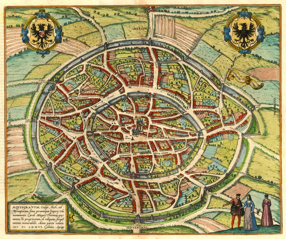
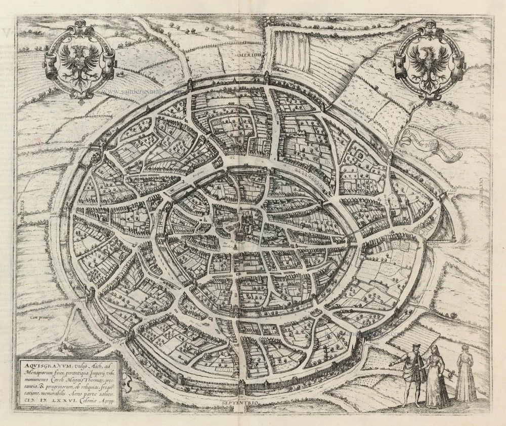
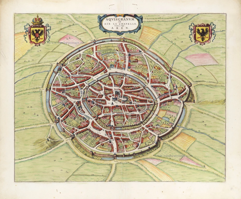
Aachen, by Braun and Hogenberg. 1572-1624
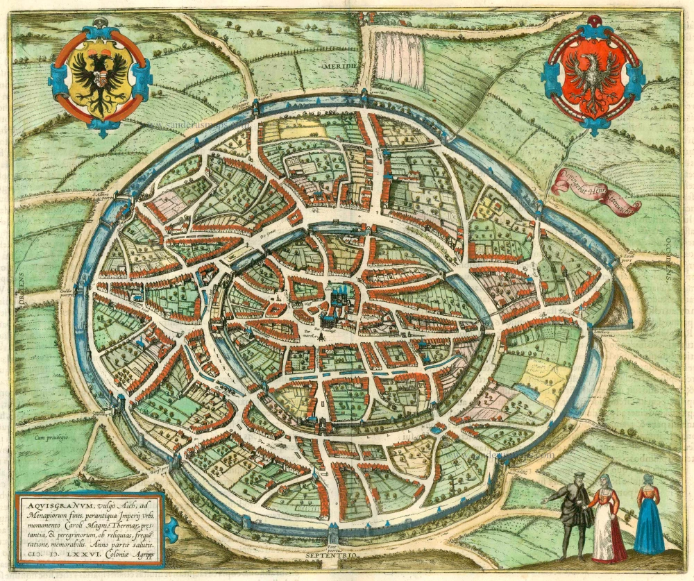

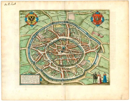
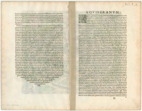
TRANSLATION OF CARTOUCHE TEXT: Aquisgranum, or Aachen, is situated on the borders of the territory of the Menapii, an ancient imperial city.
COMMENTARY BY BRAUN: "The imperial city of Aachen lies between the Rhine and the Meuse on the border of the Duchy of Jülich and has become famous for the first coronation of a Roman emperor and the burial place of Charlemagne and the pilgrimage every seven years."
This plan of Aachen from a birds-eye perspective appeared in 1582 in the new edition of the first volume. Two elliptical city walls schematically surround it. The open marketplace, the Gothic façade of the town and the distinctive octagon with westwork and Gothic choir chapel of the cathedral can be seen precisely in the centre; the townhouses, on the other hand, are miniaturized, and the streets and squares are vast for the sake of greater clarity. Aachen played a central role in the Holy Roman Empire. For this reason, Braun emphasizes the "Heiltumsfahrt" (pilgrimage to the sacred relics), the construction of the palace and the Palatine chapel (c.800) and the hot sulphur springs, which had been appreciated earlier by the Romans. The Old High German word Ahha (Acha) means water; the Romans called the site Aquae Grani, later Aquisgranum, after Grannus, the god of healing. Thirty-two kings were crowned in Aachen, the last being Ferdinand I in 1531. (Taschen).
Braun G. & Hogenberg F. and the Civitates Orbis Terrarum.
The Civitates Orbis Terrarum, or the "Braun & Hogenberg", is a six-volume town atlas and the most excellent book of town views and plans ever published: 363 engravings, sometimes beautifully coloured. It was one of the best-selling works in the last quarter of the 16th century. Georg Braun wrote the text accompanying the plans and views on the verso. Many plates were engraved after the original drawings of a professional artist, a professional artist, Joris Hoefnagel (1542-1600). The first volume was published in Latin in 1572, and the sixth in 1617. Frans Hogenberg created the tables for volumes I through IV, and Simon van den Neuwel made those for volumes V and VI. Other contributors were cartographers Daniel Freese and Heinrich Rantzau. Works by Jacob van Deventer, Sebastian Münster, and Johannes Stumpf were also used. Translations appeared in German and French.
Following the original publication of Volume 1 of the Civitates in 1572, seven further editions of 1575, 1577, 1582, 1588, 1593, 1599 and 1612 can be identified. Vol.2, first issued in 1575, was followed by further editions in 1597 and 1612. The subsequent volumes appeared in 1581, 1588, 1593, 1599 and 1606. The German translation of the first volume appeared from 1574 on, and the French edition from 1575 on.
Several printers were involved: Theodor Graminaeus, Heinrich von Aich, Gottfried von Kempen, Johannis Sinniger, Bertram Buchholtz and Peter von Brachel, who all worked in Cologne.
Georg Braun (1541-1622)
Georg Braun was born in Cologne in 1541. After his studies in Cologne, he entered the Jesuit Order as a novice. 1561, he obtained his bachelor's degree, and in 1562, he received his Magister Artium. Although he left the Jesuit Order, he studied theology, gaining a licentiate in theology.
Frans Hogenberg (1535-1590)
Frans Hogenberg was a Flemish and German painter, engraver, and mapmaker. He was born in Mechelen as the son of Nicolaas Hogenberg.
By the end of the 1560s, Frans Hogenberg was employed upon Abraham Ortelius's Theatrum Orbis Terrarum, published in 1570; he is named an engraver of numerous maps. In 1568, he was banned from Antwerp by the Duke of Alva and travelled to London, where he stayed a few years before emigrating to Cologne. He immediately embarked on his two most important works, the Civitates, published in 1572 and the Geschichtsblätter, which appeared in several series from 1569 until about 1587.
Thanks to large-scale projects like the Geschichtsblätter and the Civitates, Hogenberg's social circumstances improved with each passing year. He died as a wealthy man in Cologne in 1590.
Aquisgranum, vulgo Aich, ad Menapiorum fines, perantiqua Imperij Urbs, Monumento Caroli Magni, ...
Item Number: 22309 Authenticity Guarantee
Category: Antique maps > Europe > Germany - Cities
Old, antique birds-eye view plan of Aachen by Braun and Hogenberg, after Hendrick Steenwijck.
Title: Aquisgranum, vulgo Aich, ad Menapiorum fines, perantiqua Imperij Urbs, Monumento Caroli Magni, ...
Date: 1572-1624.
Copper engraving, printed on paper.
Size (not including margins): 325 x 385mm (12.8 x 15.16 inches).
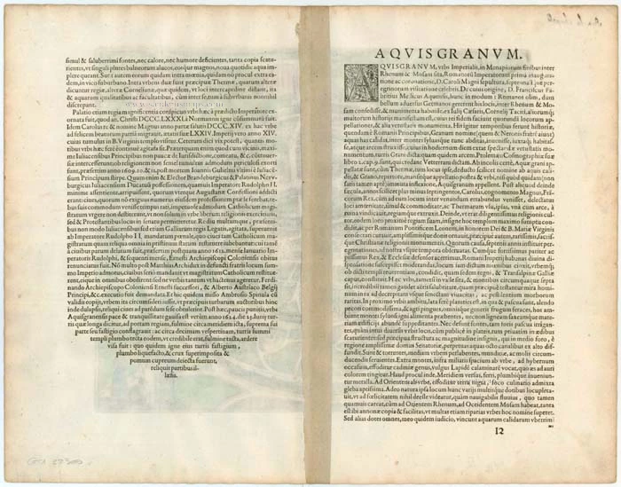
Verso: Latin text.
Condition: Original coloured, excellent.
Condition Rating: A+.
From: Civitates Orbis Terrarum, ... Part 1. Köln, 1572-1624. (Van der Krogt 4, 41:1.1)
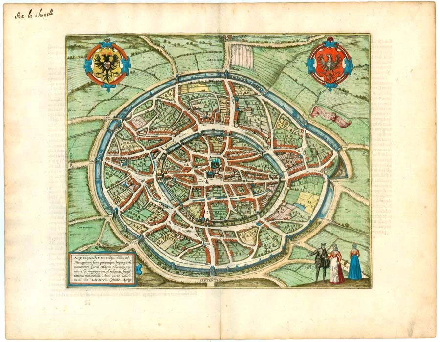
TRANSLATION OF CARTOUCHE TEXT: Aquisgranum, or Aachen, is situated on the borders of the territory of the Menapii, an ancient imperial city.
COMMENTARY BY BRAUN: "The imperial city of Aachen lies between the Rhine and the Meuse on the border of the Duchy of Jülich and has become famous for the first coronation of a Roman emperor and the burial place of Charlemagne and the pilgrimage every seven years."
This plan of Aachen from a birds-eye perspective appeared in 1582 in the new edition of the first volume. Two elliptical city walls schematically surround it. The open marketplace, the Gothic façade of the town and the distinctive octagon with westwork and Gothic choir chapel of the cathedral can be seen precisely in the centre; the townhouses, on the other hand, are miniaturized, and the streets and squares are vast for the sake of greater clarity. Aachen played a central role in the Holy Roman Empire. For this reason, Braun emphasizes the "Heiltumsfahrt" (pilgrimage to the sacred relics), the construction of the palace and the Palatine chapel (c.800) and the hot sulphur springs, which had been appreciated earlier by the Romans. The Old High German word Ahha (Acha) means water; the Romans called the site Aquae Grani, later Aquisgranum, after Grannus, the god of healing. Thirty-two kings were crowned in Aachen, the last being Ferdinand I in 1531. (Taschen).
Braun G. & Hogenberg F. and the Civitates Orbis Terrarum.
The Civitates Orbis Terrarum, or the "Braun & Hogenberg", is a six-volume town atlas and the most excellent book of town views and plans ever published: 363 engravings, sometimes beautifully coloured. It was one of the best-selling works in the last quarter of the 16th century. Georg Braun wrote the text accompanying the plans and views on the verso. Many plates were engraved after the original drawings of a professional artist, a professional artist, Joris Hoefnagel (1542-1600). The first volume was published in Latin in 1572, and the sixth in 1617. Frans Hogenberg created the tables for volumes I through IV, and Simon van den Neuwel made those for volumes V and VI. Other contributors were cartographers Daniel Freese and Heinrich Rantzau. Works by Jacob van Deventer, Sebastian Münster, and Johannes Stumpf were also used. Translations appeared in German and French.
Following the original publication of Volume 1 of the Civitates in 1572, seven further editions of 1575, 1577, 1582, 1588, 1593, 1599 and 1612 can be identified. Vol.2, first issued in 1575, was followed by further editions in 1597 and 1612. The subsequent volumes appeared in 1581, 1588, 1593, 1599 and 1606. The German translation of the first volume appeared from 1574 on, and the French edition from 1575 on.
Several printers were involved: Theodor Graminaeus, Heinrich von Aich, Gottfried von Kempen, Johannis Sinniger, Bertram Buchholtz and Peter von Brachel, who all worked in Cologne.
Georg Braun (1541-1622)
Georg Braun was born in Cologne in 1541. After his studies in Cologne, he entered the Jesuit Order as a novice. 1561, he obtained his bachelor's degree, and in 1562, he received his Magister Artium. Although he left the Jesuit Order, he studied theology, gaining a licentiate in theology.
Frans Hogenberg (1535-1590)
Frans Hogenberg was a Flemish and German painter, engraver, and mapmaker. He was born in Mechelen as the son of Nicolaas Hogenberg.
By the end of the 1560s, Frans Hogenberg was employed upon Abraham Ortelius's Theatrum Orbis Terrarum, published in 1570; he is named an engraver of numerous maps. In 1568, he was banned from Antwerp by the Duke of Alva and travelled to London, where he stayed a few years before emigrating to Cologne. He immediately embarked on his two most important works, the Civitates, published in 1572 and the Geschichtsblätter, which appeared in several series from 1569 until about 1587.
Thanks to large-scale projects like the Geschichtsblätter and the Civitates, Hogenberg's social circumstances improved with each passing year. He died as a wealthy man in Cologne in 1590.
Related items

Aich - Aquisgranum, Urbs Prae Clarissima, Primum, Inter Quatuor Imperii Civitates, Locum Obtinet. 1572
Aachen, by Georg Braun & Frans Hogenberg.
[Item number: 9173]
Aquisgranum, vulgo Aich, ad Menapiorum fines, perantiqua Imperij Urbs, Monumento Caroli Magni, ... 1572-1624
Aachen, by Georg Braun and Frans Hogenberg.
[Item number: 19178]
Aquisgranum, vulgo Aich, ad Menapiorum fines, perantiqua Imperij Urbs, M0onumento Caroli Magni, ... 1599
Aachen, by Georg Braun and Frans Hogenberg.
[Item number: 23907]
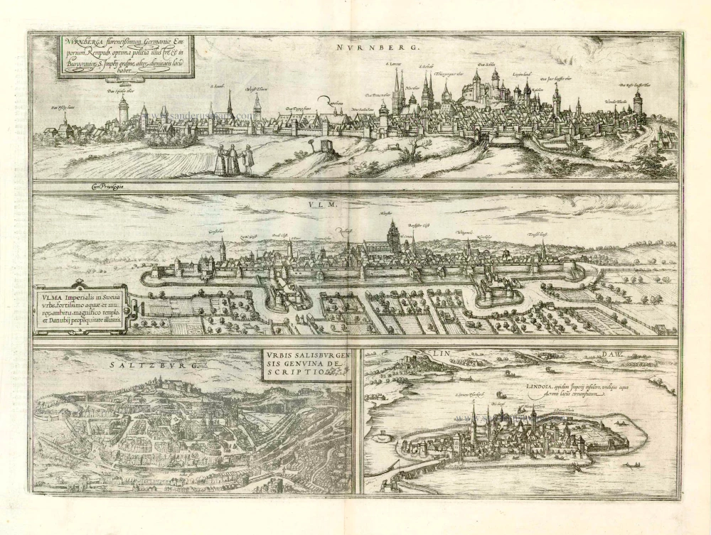
Nurnberga Florentissimum Germaniae Emporium, ... [on sheet with] Ulma Imperialis in Suevia [and] Saltzburg Urbis Salisburgensis Genvina Descriptio [and] Lindaw - Lindoia, Oppidum Imperij insulare, ... 1599
Nürnberg, Ulm, Salzburg, and Lindau, by Georg Braun and Frans Hogenberg.
[Item number: 23926]
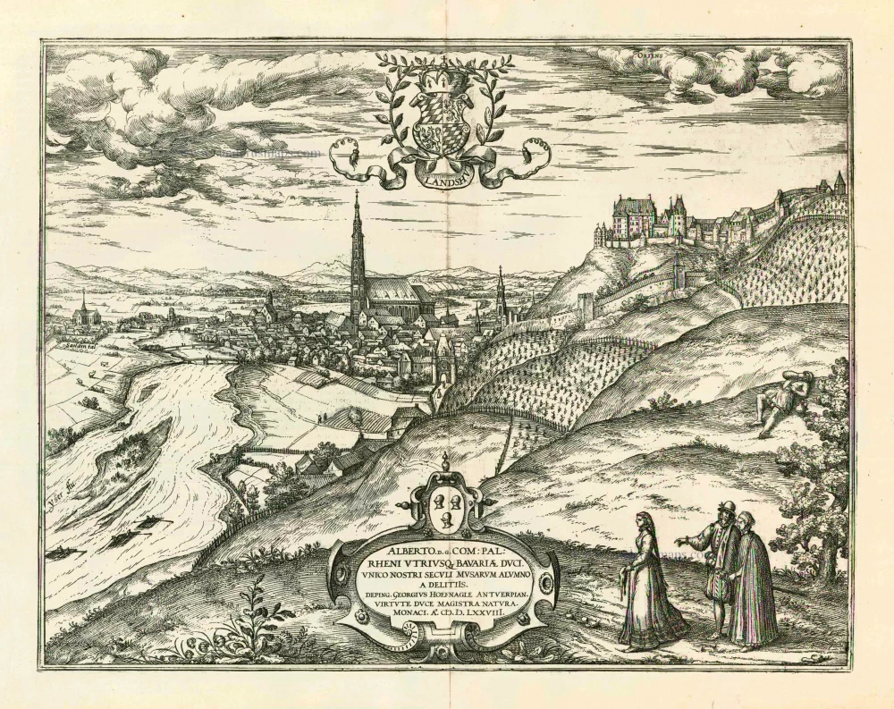
Landshut 1599
Landshut, by Georg Braun and Frans Hogenberg.
[Item number: 24060]
Aquisgranum Gallis Aix La Chapelle Germanis et Belgis Aken. 1649
Aachen, by Joan Blaeu.
[Item number: 28940]