
Sweden - Norrland by Blaeu J. 1662
The Blaeus: Willem Janszoon, Cornelis & Joan
Willem Jansz. Blaeu and his son Joan Blaeu are the seventeenth century's most widely known cartographic publishers.
Willem Jansz. (also written Guilielmus Janssonius) = Willem Janszoon Blaeu was born in Uitgeest (Netherlands), near Alkmaar, in 1571. He studied mathematics under Tycho Brahe and learned the theory and practice of astronomical observations and the art of instrument- and globe-making.
In 1596, he came to Amsterdam, where he settled down as a globe-, instrument- and map-maker. He published his first cartographic work (a globe) in 1599 and probably published his first printed map (a map of the Netherlands) in 1604. He specialised in maritime cartography, published the first edition of the pilot guide Het Licht der Zeevaert in 1608, and was appointed Hydrographer of the V.O.C. (United East India Company) in 1633. After publishing books, wall maps, globes, charts and pilot guides for thirty years, he brought out his first atlas, Atlas Appendix (1630). This was the beginning of the great tradition of atlas-making by the Blaeus.
In 1618, another mapmaker, bookseller and publisher, Johannes Janssonius, established himself in Amsterdam next door to Blaeu's shop. No wonder these two neighbours began accusing each other of copying and stealing their information and became fierce competitors who did not have a good word to say about each other. In about 1621 Willem Jansz. decided to end the confusion between his name and his competitor's and assumed his grandfather's nickname, 'blauwe Willem' ('blue Willem'), as the family name; after that, he called himself Willem Jansz. Blaeu.
Willem Janszoon Blaeu died in 1638, leaving his prospering business to his sons, Cornelis and Joan. We only know that Cornelis's name occurs in the prefaces of books and atlases until c. 1645.
Joan Blaeu, born in Amsterdam in 1596, became a partner in his father’s book trade and printing business. 1638, he was appointed his father’s successor in the Hydrographic Office of the V.O.C. His efforts culminated in the magnificent Atlas Major and the town books of the Netherlands and Italy – works unsurpassed in history and modern times, giving eternal fame to the name of the Blaeu's.
On February 23, 1672, a fire ruined the business. One year later, Dr Joan Blaeu died. The fire of 1672 and the passing away of the director gave rise to a complete sale of the stock of the Blaeu House. Five public auctions dispersed the remaining books, atlases, copperplates, globes, etc., among many other map dealers and publishers in Amsterdam. The majority was acquired by several booksellers acting in partnership.
In the succeeding years, the remaining printing department was left in the hands of the Blaeu family until 1695, when the printing house's inventory was sold at a public auction. That meant the end of the Blaeu's as a printing house of world renown.
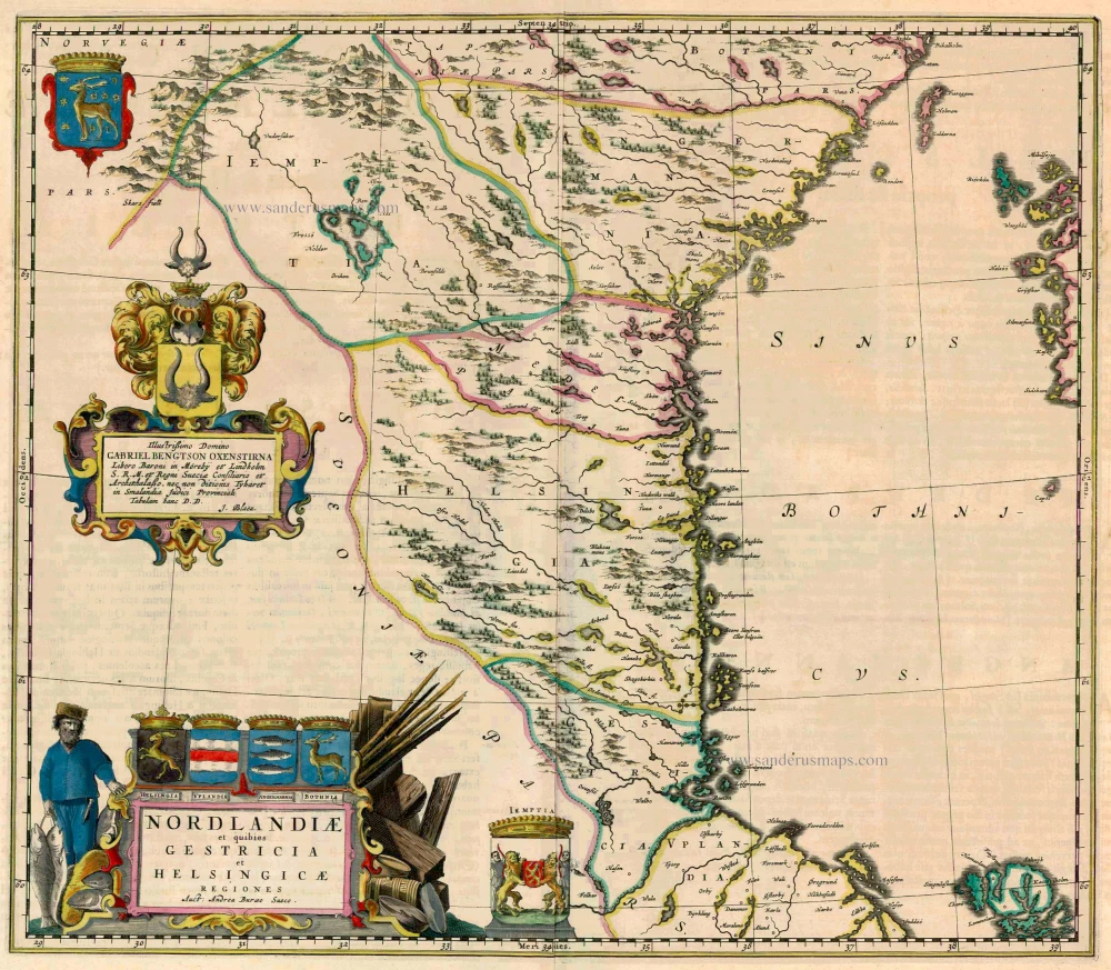
Nordlandiae et quibies Gestricia et Helsingicae
Item Number: 23141 Authenticity Guarantee
Category: Antique maps > Europe > Northern Europe
Sweden - Norrland by Blaeu J.
Title: Nordlandiae et quibies Gestricia et Helsingicae
Regiones Auct: Andrea Buraeo Sueco.
Dedicated to Gabriel Bengtson Oxenstirma by Joan Blaeu.
Cartographer: Andreas Bureus (1571-1646).
Date of the first edition: 1662.
Date of this map: 1662.
Copper engraving, printed on paper.
Size (not including margins): 413 x 483mm (16.26 x 19.02 inches).
Verso: Latin text.
Condition: Original coloured, slight shine-through of verso text.
Condition Rating: A.
From: Atlas Maior, Sive Cosmographia Blaviana, Qua Solum, Salum, Coelum, Accuratissime Describuntur. Amsterdam, J. Blaeu, 1662-65. (Van der Krogt 2, 601-3)
The Blaeus: Willem Janszoon, Cornelis & Joan
Willem Jansz. Blaeu and his son Joan Blaeu are the seventeenth century's most widely known cartographic publishers.
Willem Jansz. (also written Guilielmus Janssonius) = Willem Janszoon Blaeu was born in Uitgeest (Netherlands), near Alkmaar, in 1571. He studied mathematics under Tycho Brahe and learned the theory and practice of astronomical observations and the art of instrument- and globe-making.
In 1596, he came to Amsterdam, where he settled down as a globe-, instrument- and map-maker. He published his first cartographic work (a globe) in 1599 and probably published his first printed map (a map of the Netherlands) in 1604. He specialised in maritime cartography, published the first edition of the pilot guide Het Licht der Zeevaert in 1608, and was appointed Hydrographer of the V.O.C. (United East India Company) in 1633. After publishing books, wall maps, globes, charts and pilot guides for thirty years, he brought out his first atlas, Atlas Appendix (1630). This was the beginning of the great tradition of atlas-making by the Blaeus.
In 1618, another mapmaker, bookseller and publisher, Johannes Janssonius, established himself in Amsterdam next door to Blaeu's shop. No wonder these two neighbours began accusing each other of copying and stealing their information and became fierce competitors who did not have a good word to say about each other. In about 1621 Willem Jansz. decided to end the confusion between his name and his competitor's and assumed his grandfather's nickname, 'blauwe Willem' ('blue Willem'), as the family name; after that, he called himself Willem Jansz. Blaeu.
Willem Janszoon Blaeu died in 1638, leaving his prospering business to his sons, Cornelis and Joan. We only know that Cornelis's name occurs in the prefaces of books and atlases until c. 1645.
Joan Blaeu, born in Amsterdam in 1596, became a partner in his father’s book trade and printing business. 1638, he was appointed his father’s successor in the Hydrographic Office of the V.O.C. His efforts culminated in the magnificent Atlas Major and the town books of the Netherlands and Italy – works unsurpassed in history and modern times, giving eternal fame to the name of the Blaeu's.
On February 23, 1672, a fire ruined the business. One year later, Dr Joan Blaeu died. The fire of 1672 and the passing away of the director gave rise to a complete sale of the stock of the Blaeu House. Five public auctions dispersed the remaining books, atlases, copperplates, globes, etc., among many other map dealers and publishers in Amsterdam. The majority was acquired by several booksellers acting in partnership.
In the succeeding years, the remaining printing department was left in the hands of the Blaeu family until 1695, when the printing house's inventory was sold at a public auction. That meant the end of the Blaeu's as a printing house of world renown.
Related items
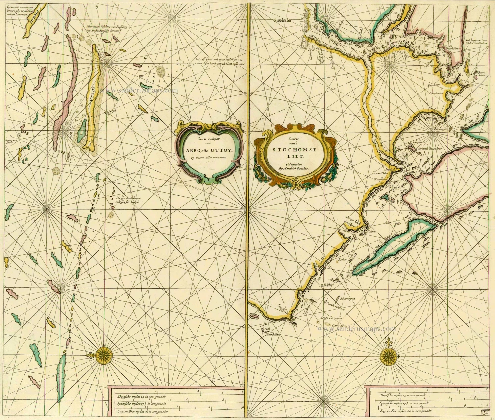
Caarte van 't gat van Abbo, ofte Uttoy. [on sheet with] Caarte van 't Stochomse Liet. 1686
Sea chart of Finland - Sweden, by Doncker H.
[Item number: 14593]

Carte de la Maison du Roy, des Etats, des Conseils et du Gouvernement Civil, Ecclesiastique, et militaire de Suède. 1713-1719
Sweden - Stockholm, by Zacharias Châtelain.
[Item number: 21340]
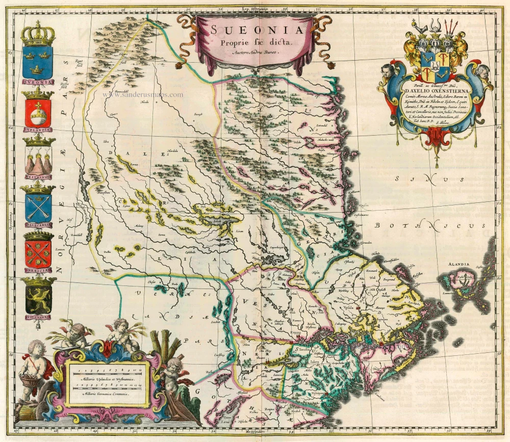
Sueonia Proprie sic dicta. 1662
Sweden - Svealand, by Blaeu J.
[Item number: 22827]

Nieuwe Paskaert van het Stockholmse Liet 1697-1709
Sweden - Stockholm, by Johannes Van Keulen.
[Item number: 12460]
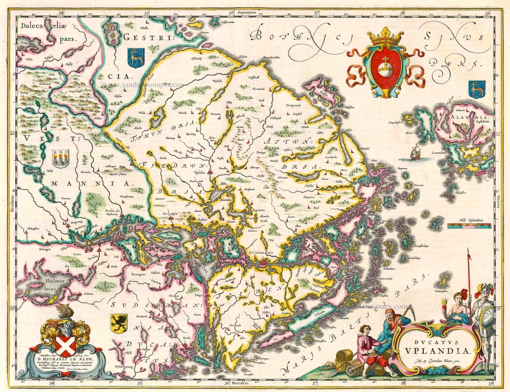
Ducatus Uplandia 1644
Uppland (Sweden), by Joan Blaeu.
[Item number: 21398]
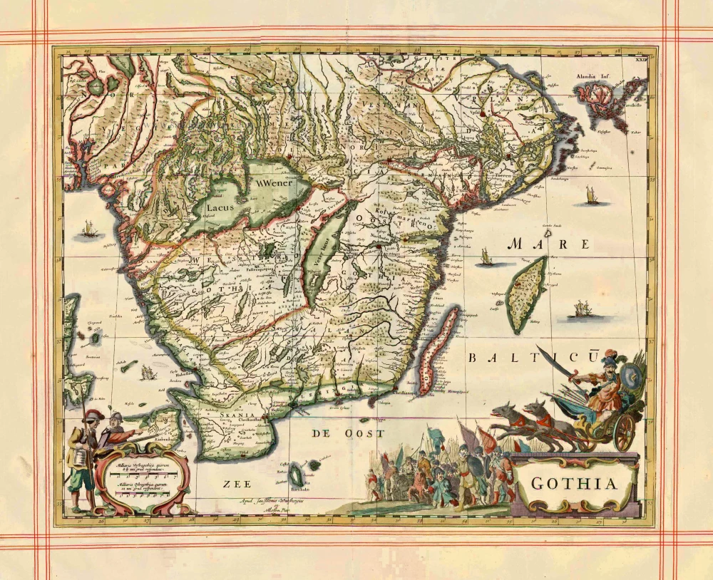
Gothia 1680
Sweden - Götaland, by J. Janssonius, published by Pitt Moses & J. Janssonius-Waesberge.
[Item number: 1290]
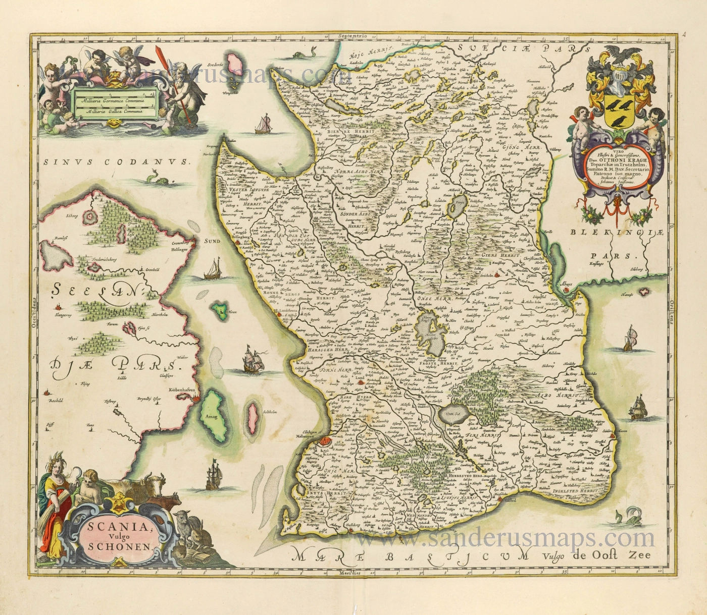
Scania, Vulgo Schonen. c. 1678
Scania (Skåne) by Johannes Janssonius.
[Item number: 28520]
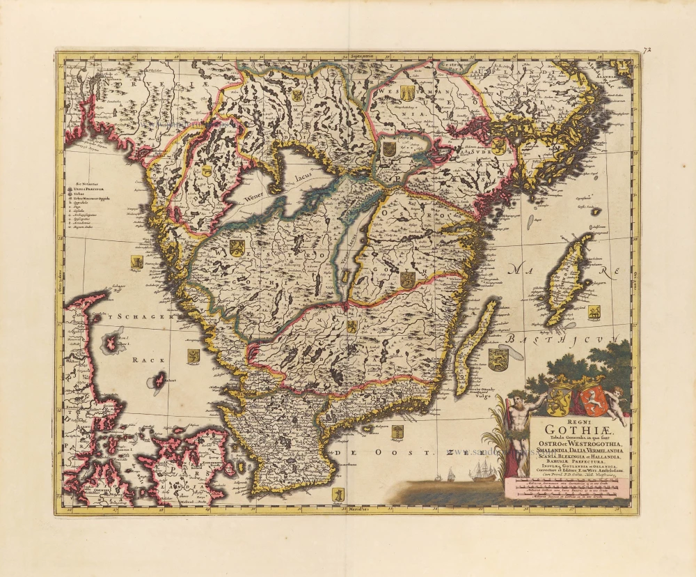
Regni Gothiae, Tabula Generalis, in qua sont Ostro et Westrogothia, Smalandia, Dalia, Vermelandia, Scania, Blekingia et Hallandia, Bahusiae, Prefectura, Insulae q. Gotandia et Oelandia, c. 1690
Southern Sweden by Frederick de Wit.
[Item number: 28812]

Accurata Scaniae, Blekingiae, et Hallandiae Descriptio. c. 1705
Southern Sweden by Frederick De Wit.
[Item number: 28832]
Only in the Atlas Maior.
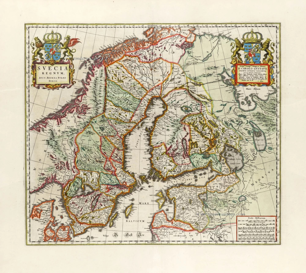
Suecia Regnum, 1663
Sweden, by Joan Blaeu.
[Item number: 30098]
First edition
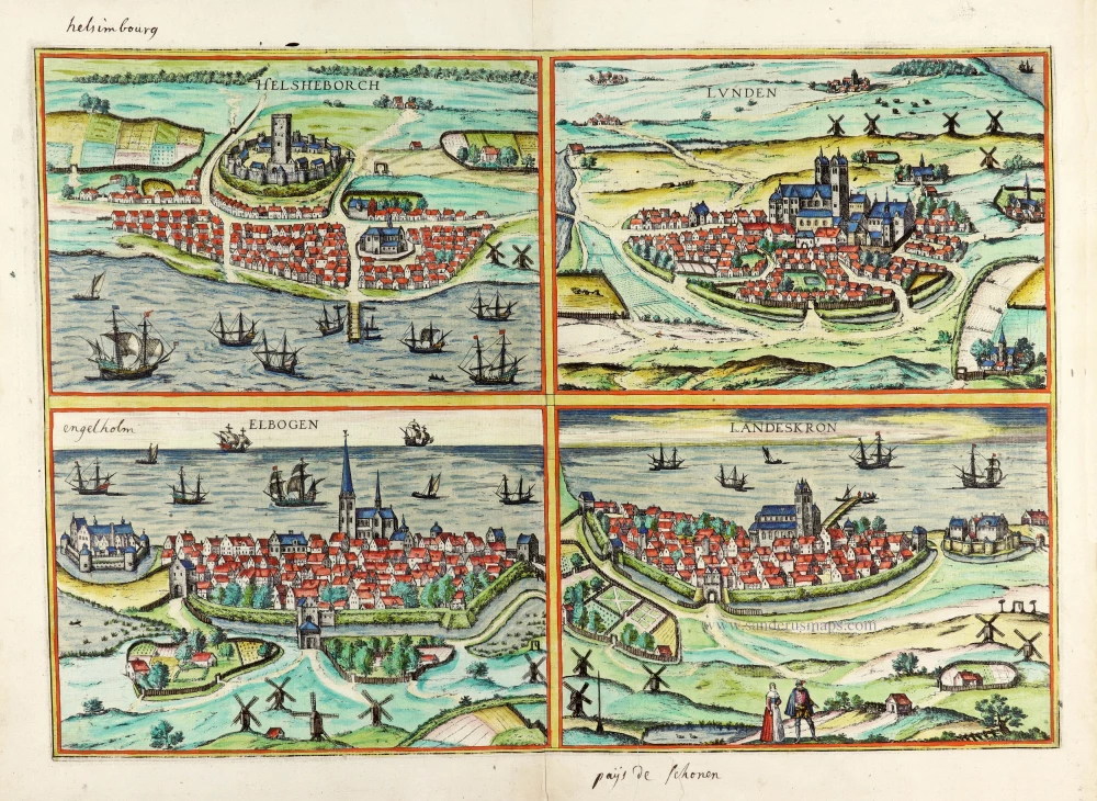
Helsheborch [on sheet with] Lunden [and] Elbogen [and] Landeskron. 1588
Braun and Hogenberg : Malmö, Helsingborg, Lund, Landskrona.
[Item number: 30136]