
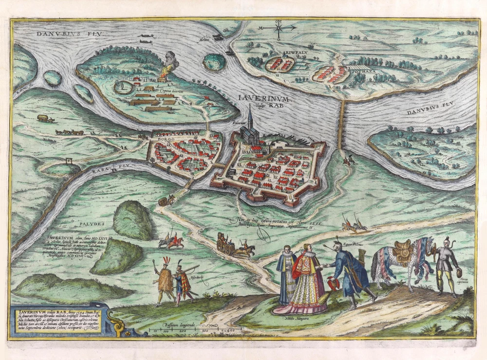
Hungary - Tata, by Braun & Hogenberg. 1618


Braun G. & Hogenberg F. and the Civitates Orbis Terrarum.
The Civitates Orbis Terrarum, or the "Braun & Hogenberg", is a six-volume town atlas and the most excellent book of town views and plans ever published: 363 engravings, sometimes beautifully coloured. It was one of the best-selling works in the last quarter of the 16th century. Georg Braun wrote the text accompanying the plans and views on the verso. Many plates were engraved after the original drawings of a professional artist, a professional artist, Joris Hoefnagel (1542-1600). The first volume was published in Latin in 1572, and the sixth in 1617. Frans Hogenberg created the tables for volumes I through IV, and Simon van den Neuwel made those for volumes V and VI. Other contributors were cartographers Daniel Freese and Heinrich Rantzau. Works by Jacob van Deventer, Sebastian Münster, and Johannes Stumpf were also used. Translations appeared in German and French.
Following the original publication of Volume 1 of the Civitates in 1572, seven further editions of 1575, 1577, 1582, 1588, 1593, 1599 and 1612 can be identified. Vol.2, first issued in 1575, was followed by further editions in 1597 and 1612. The subsequent volumes appeared in 1581, 1588, 1593, 1599 and 1606. The German translation of the first volume appeared from 1574 on, and the French edition from 1575 on.
Several printers were involved: Theodor Graminaeus, Heinrich von Aich, Gottfried von Kempen, Johannis Sinniger, Bertram Buchholtz and Peter von Brachel, who all worked in Cologne.
Georg Braun (1541-1622)
Georg Braun was born in Cologne in 1541. After his studies in Cologne, he entered the Jesuit Order as a novice. 1561, he obtained his bachelor's degree, and in 1562, he received his Magister Artium. Although he left the Jesuit Order, he studied theology, gaining a licentiate in theology.
Frans Hogenberg (1535-1590)
Frans Hogenberg was a Flemish and German painter, engraver, and mapmaker. He was born in Mechelen as the son of Nicolaas Hogenberg.
By the end of the 1560s, Frans Hogenberg was employed upon Abraham Ortelius's Theatrum Orbis Terrarum, published in 1570; he is named an engraver of numerous maps. In 1568, he was banned from Antwerp by the Duke of Alva and travelled to London, where he stayed a few years before emigrating to Cologne. He immediately embarked on his two most important works, the Civitates, published in 1572 and the Geschichtsblätter, which appeared in several series from 1569 until about 1587.
Thanks to large-scale projects like the Geschichtsblätter and the Civitates, Hogenberg's social circumstances improved with each passing year. He died as a wealthy man in Cologne in 1590.
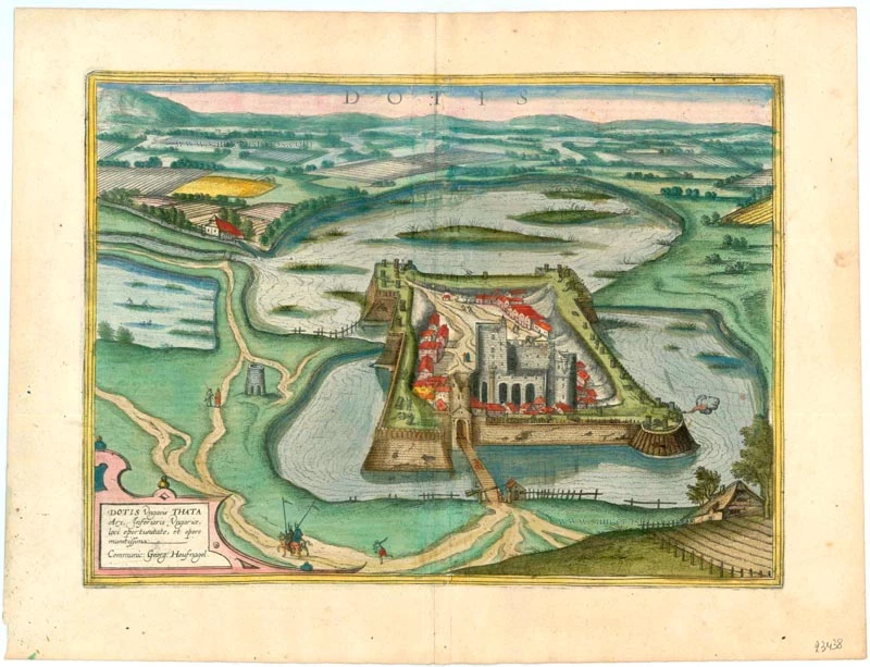
Dotis Ungaris Thata
Item Number: 23438 Authenticity Guarantee
Category: Antique maps > Europe > Central Europe
Bird's-eye view of Tata in Hungary by G. Hoefnagel.
TRANSLATION OF CARTOUCHE TEXT: Dotis, in Hungarian Tata, a castle in Lower Hungary, well fortified due to its favourable position and by human exertion. Procured by Georg Hoefnagel.
COMMENTARY BY BRAUN: "The castle is well secured today with very deep moats and ramparts of earth and timber, but on the other hand not so well that it would be able to resist a siege for a long time. Together with Veszprém and other fortresses in the same region, it became Turkish under Sultan Süleyman, but was then recaptured by Count Ecken of Salm in 1566."
The town of Tata is not visible in this plate, which shows the fortress-like castle in the middle of a marshy landscape, in cavalier perspective from the northwest. Many holes in the outer walls and on the castle, which has been damaged in places by cannon fire, bear witness to armed conflicts. This is further underlined by the depiction of a cannon that has just been fired in the round corner bastion in the lower right-hand corner. The 14th-century castle was taken by the Ottomans in 1560, but was subsequently recaptured. It was then extended to a mighty fortress with walls built according to the Italian model. In the 18th century the castle passed into the possesion of the Esterházy family, who gave the town some magnificent Barocque buildings. (Taschen)
Date: 1618
First edition: 1617
Copper engraving
Size: 32.5 x 44.5cm (12.7 x 17.4 inches)
Verso text: Latin
Condition: Excellent, superb old colour.
Condition Rating: A+
References: Van der Krogt 4, 4264; Taschen, Braun and Hogenberg, p.470
From: Theatri praecipuarum Totius Mundi Urbium Liber Sextus Anno MDCXVIII. (Koeman, B&H6)
Braun G. & Hogenberg F. and the Civitates Orbis Terrarum.
The Civitates Orbis Terrarum, or the "Braun & Hogenberg", is a six-volume town atlas and the most excellent book of town views and plans ever published: 363 engravings, sometimes beautifully coloured. It was one of the best-selling works in the last quarter of the 16th century. Georg Braun wrote the text accompanying the plans and views on the verso. Many plates were engraved after the original drawings of a professional artist, a professional artist, Joris Hoefnagel (1542-1600). The first volume was published in Latin in 1572, and the sixth in 1617. Frans Hogenberg created the tables for volumes I through IV, and Simon van den Neuwel made those for volumes V and VI. Other contributors were cartographers Daniel Freese and Heinrich Rantzau. Works by Jacob van Deventer, Sebastian Münster, and Johannes Stumpf were also used. Translations appeared in German and French.
Following the original publication of Volume 1 of the Civitates in 1572, seven further editions of 1575, 1577, 1582, 1588, 1593, 1599 and 1612 can be identified. Vol.2, first issued in 1575, was followed by further editions in 1597 and 1612. The subsequent volumes appeared in 1581, 1588, 1593, 1599 and 1606. The German translation of the first volume appeared from 1574 on, and the French edition from 1575 on.
Several printers were involved: Theodor Graminaeus, Heinrich von Aich, Gottfried von Kempen, Johannis Sinniger, Bertram Buchholtz and Peter von Brachel, who all worked in Cologne.
Georg Braun (1541-1622)
Georg Braun was born in Cologne in 1541. After his studies in Cologne, he entered the Jesuit Order as a novice. 1561, he obtained his bachelor's degree, and in 1562, he received his Magister Artium. Although he left the Jesuit Order, he studied theology, gaining a licentiate in theology.
Frans Hogenberg (1535-1590)
Frans Hogenberg was a Flemish and German painter, engraver, and mapmaker. He was born in Mechelen as the son of Nicolaas Hogenberg.
By the end of the 1560s, Frans Hogenberg was employed upon Abraham Ortelius's Theatrum Orbis Terrarum, published in 1570; he is named an engraver of numerous maps. In 1568, he was banned from Antwerp by the Duke of Alva and travelled to London, where he stayed a few years before emigrating to Cologne. He immediately embarked on his two most important works, the Civitates, published in 1572 and the Geschichtsblätter, which appeared in several series from 1569 until about 1587.
Thanks to large-scale projects like the Geschichtsblätter and the Civitates, Hogenberg's social circumstances improved with each passing year. He died as a wealthy man in Cologne in 1590.
Related items
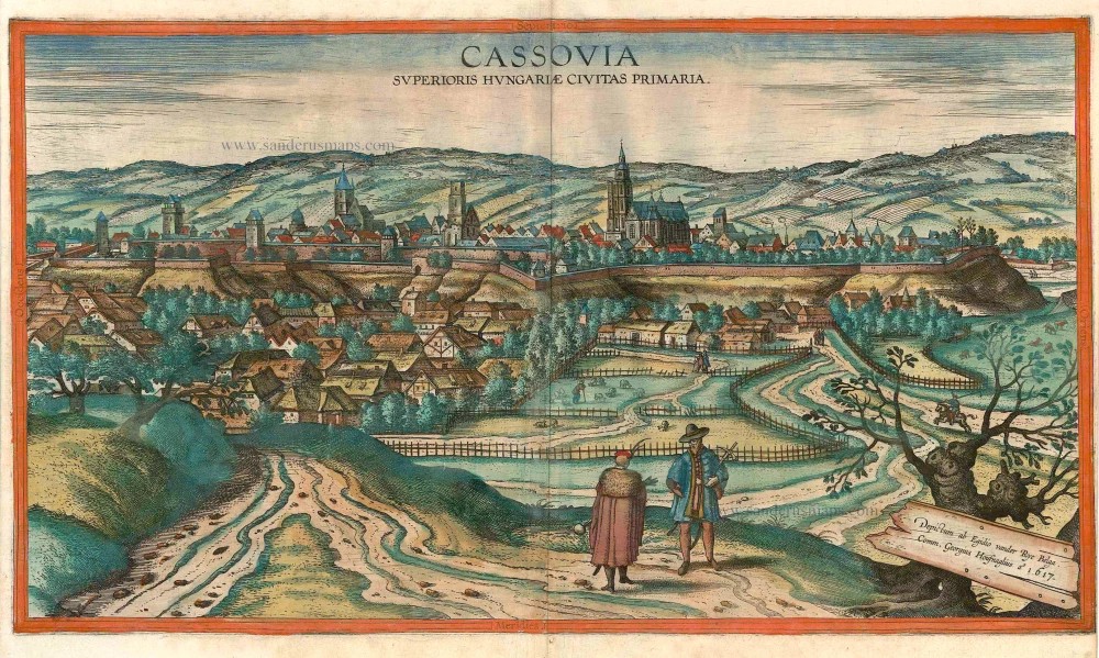
Cassovia superioris Hungariae civitas primaria. c. 1625
Kosice (Hungary) by Georg Braun & Frans Hogenberg.
[Item number: 16448]
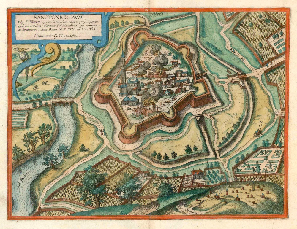
Sanctonicolaum vulgo S. Nicolas Oppidum in Superiore Hungaria prope Zolnochium quod ipsi met Turcae ... c. 1625
Törökszentmiklos by Braun G. & Hogenberg F.
[Item number: 16453]
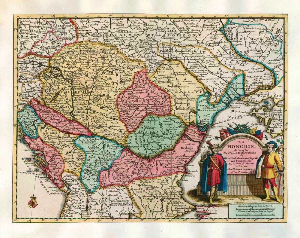
La Hongrie, Suivant les Nouvelles Observations de Mess.rs de l'Academie Royale des Sciences, 1713
Hungary, by Pieter van der Aa.
[Item number: 26043]
Iaverinum vulgo Rab. 1617
Györ in Hungary by Braun and Hogenberg.
[Item number: 29854]