
Tricarico, by Braun & Hogenberg. 1618
The item displayed on this page has been sold. However, we have a similar map in stock:
Tricarico by Braun G. & Hogenberg F. c. 1625
Tricaricum Basilicatae Civitas.
[Item number: 16652]

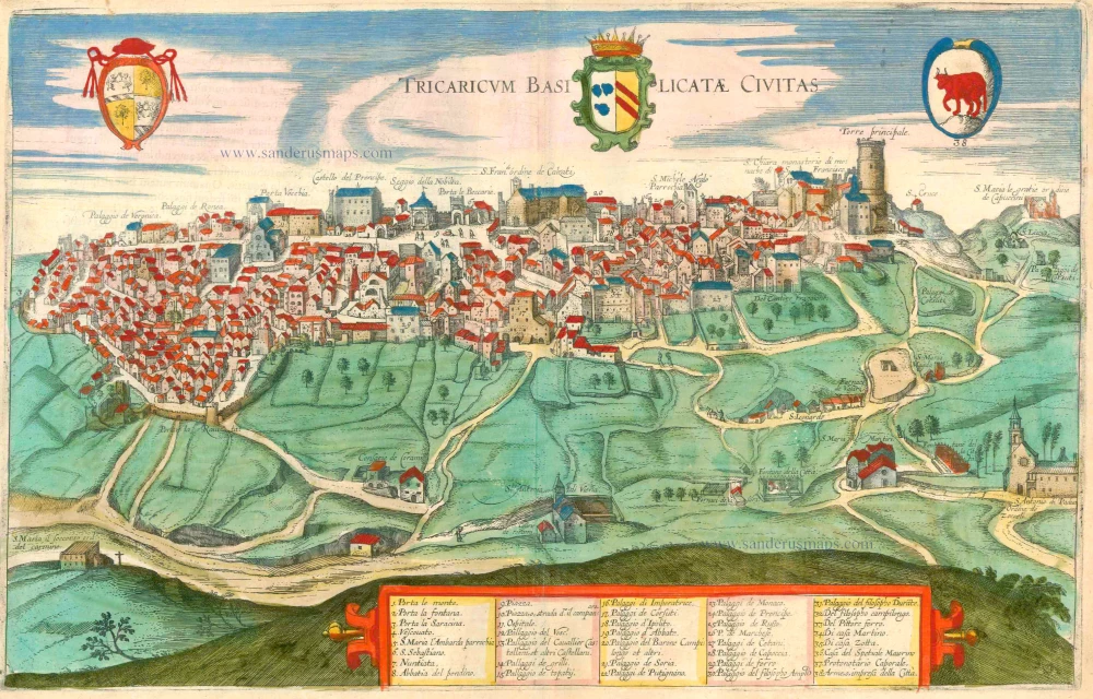


CAPTION: Tricarico is a city in the Basilicata.
COMMENTARY BY BRAUN: "The city of Tricaricolies is in a territory of the Neapolitan Kingdom, formerly Luciania, but is today Basilicata. Many say it was built out of two ruined towns, one formerly called Tricae and the other Aegie (for which reason it has kept both names). There is a diocese here, and besides the bishop's church, many splendid monasteries and churches, in which precious relics and sacred objects are kept, such as the bones of the holy Abbot Antonius, which give out a powerful light and are kept in the main church with proper reverence and respect."
This is a view from the west of Tricarico, situated on the ridge of a hill. The most prominent feature is the Norman tower to the south, which today is the town's landmark. Alongside it are many noble palaces, churches and monasteries. On the left is the cathedral of Santa Maria Assunta (4), which goes back to Robert Guiscard, next to the Norman castle (Castello del Prencipe). Here, Louis I of Anjou was crowned king of Naples in 1383. There is archaeological evidence of settlements here in prehistorical and Roman times. The town was fortified in the Lombardian period, alternately a Saracen and Byzantine fortress, and in the 11th/12th centuries, the centre of a critical Norman county. The bishopric's founding goes back to AD 968, first as a suffragan of the Orthodox city of Hydrus (Otranto). (Taschen)
Braun G. & Hogenberg F. and the Civitates Orbis Terrarum.
The Civitates Orbis Terrarum, or the "Braun & Hogenberg", is a six-volume town atlas and the most excellent book of town views and plans ever published: 363 engravings, sometimes beautifully coloured. It was one of the best-selling works in the last quarter of the 16th century. Georg Braun wrote the text accompanying the plans and views on the verso. Many plates were engraved after the original drawings of a professional artist, a professional artist, Joris Hoefnagel (1542-1600). The first volume was published in Latin in 1572, and the sixth in 1617. Frans Hogenberg created the tables for volumes I through IV, and Simon van den Neuwel made those for volumes V and VI. Other contributors were cartographers Daniel Freese and Heinrich Rantzau. Works by Jacob van Deventer, Sebastian Münster, and Johannes Stumpf were also used. Translations appeared in German and French.
Following the original publication of Volume 1 of the Civitates in 1572, seven further editions of 1575, 1577, 1582, 1588, 1593, 1599 and 1612 can be identified. Vol.2, first issued in 1575, was followed by further editions in 1597 and 1612. The subsequent volumes appeared in 1581, 1588, 1593, 1599 and 1606. The German translation of the first volume appeared from 1574 on, and the French edition from 1575 on.
Several printers were involved: Theodor Graminaeus, Heinrich von Aich, Gottfried von Kempen, Johannis Sinniger, Bertram Buchholtz and Peter von Brachel, who all worked in Cologne.
Georg Braun (1541-1622)
Georg Braun was born in Cologne in 1541. After his studies in Cologne, he entered the Jesuit Order as a novice. 1561, he obtained his bachelor's degree, and in 1562, he received his Magister Artium. Although he left the Jesuit Order, he studied theology, gaining a licentiate in theology.
Frans Hogenberg (1535-1590)
Frans Hogenberg was a Flemish and German painter, engraver, and mapmaker. He was born in Mechelen as the son of Nicolaas Hogenberg.
By the end of the 1560s, Frans Hogenberg was employed upon Abraham Ortelius's Theatrum Orbis Terrarum, published in 1570; he is named an engraver of numerous maps. In 1568, he was banned from Antwerp by the Duke of Alva and travelled to London, where he stayed a few years before emigrating to Cologne. He immediately embarked on his two most important works, the Civitates, published in 1572 and the Geschichtsblätter, which appeared in several series from 1569 until about 1587.
Thanks to large-scale projects like the Geschichtsblätter and the Civitates, Hogenberg's social circumstances improved with each passing year. He died as a wealthy man in Cologne in 1590.
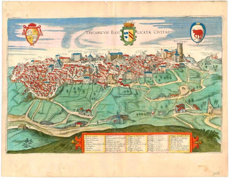
Tricaricum Basilicatae Civitas.
Item Number: 23458 Authenticity Guarantee
Category: Antique maps > Europe > Italy - Cities
Tricarico, by Braun & Hogenberg.
Title: Tricaricum Basilicatae Civitas.
Date of the first edition: 1617.
Date of this map: 1618.
Copper engraving, printed on paper.
Image size: 320 x 505mm (12.6 x 19.88 inches).
Sheet size: 410 x 535mm (16.14 x 21.06 inches).
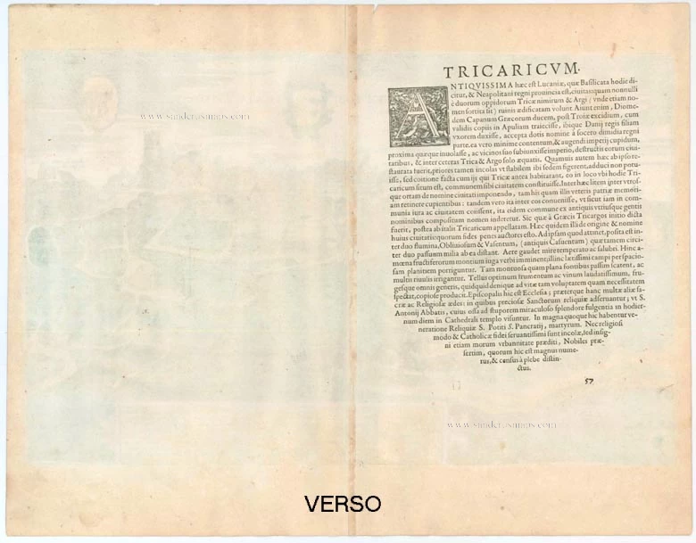
Verso: Latin text.
Condition: Excellent, superb old colour.
Condition Rating: A+.
From: Theatri praecipuarum Totius Mundi Urbium Liber Sextus Anno MDCXVIII. (Van der Krogt 4, 41:1.6)
CAPTION: Tricarico is a city in the Basilicata.
COMMENTARY BY BRAUN: "The city of Tricaricolies is in a territory of the Neapolitan Kingdom, formerly Luciania, but is today Basilicata. Many say it was built out of two ruined towns, one formerly called Tricae and the other Aegie (for which reason it has kept both names). There is a diocese here, and besides the bishop's church, many splendid monasteries and churches, in which precious relics and sacred objects are kept, such as the bones of the holy Abbot Antonius, which give out a powerful light and are kept in the main church with proper reverence and respect."
This is a view from the west of Tricarico, situated on the ridge of a hill. The most prominent feature is the Norman tower to the south, which today is the town's landmark. Alongside it are many noble palaces, churches and monasteries. On the left is the cathedral of Santa Maria Assunta (4), which goes back to Robert Guiscard, next to the Norman castle (Castello del Prencipe). Here, Louis I of Anjou was crowned king of Naples in 1383. There is archaeological evidence of settlements here in prehistorical and Roman times. The town was fortified in the Lombardian period, alternately a Saracen and Byzantine fortress, and in the 11th/12th centuries, the centre of a critical Norman county. The bishopric's founding goes back to AD 968, first as a suffragan of the Orthodox city of Hydrus (Otranto). (Taschen)
Braun G. & Hogenberg F. and the Civitates Orbis Terrarum.
The Civitates Orbis Terrarum, or the "Braun & Hogenberg", is a six-volume town atlas and the most excellent book of town views and plans ever published: 363 engravings, sometimes beautifully coloured. It was one of the best-selling works in the last quarter of the 16th century. Georg Braun wrote the text accompanying the plans and views on the verso. Many plates were engraved after the original drawings of a professional artist, a professional artist, Joris Hoefnagel (1542-1600). The first volume was published in Latin in 1572, and the sixth in 1617. Frans Hogenberg created the tables for volumes I through IV, and Simon van den Neuwel made those for volumes V and VI. Other contributors were cartographers Daniel Freese and Heinrich Rantzau. Works by Jacob van Deventer, Sebastian Münster, and Johannes Stumpf were also used. Translations appeared in German and French.
Following the original publication of Volume 1 of the Civitates in 1572, seven further editions of 1575, 1577, 1582, 1588, 1593, 1599 and 1612 can be identified. Vol.2, first issued in 1575, was followed by further editions in 1597 and 1612. The subsequent volumes appeared in 1581, 1588, 1593, 1599 and 1606. The German translation of the first volume appeared from 1574 on, and the French edition from 1575 on.
Several printers were involved: Theodor Graminaeus, Heinrich von Aich, Gottfried von Kempen, Johannis Sinniger, Bertram Buchholtz and Peter von Brachel, who all worked in Cologne.
Georg Braun (1541-1622)
Georg Braun was born in Cologne in 1541. After his studies in Cologne, he entered the Jesuit Order as a novice. 1561, he obtained his bachelor's degree, and in 1562, he received his Magister Artium. Although he left the Jesuit Order, he studied theology, gaining a licentiate in theology.
Frans Hogenberg (1535-1590)
Frans Hogenberg was a Flemish and German painter, engraver, and mapmaker. He was born in Mechelen as the son of Nicolaas Hogenberg.
By the end of the 1560s, Frans Hogenberg was employed upon Abraham Ortelius's Theatrum Orbis Terrarum, published in 1570; he is named an engraver of numerous maps. In 1568, he was banned from Antwerp by the Duke of Alva and travelled to London, where he stayed a few years before emigrating to Cologne. He immediately embarked on his two most important works, the Civitates, published in 1572 and the Geschichtsblätter, which appeared in several series from 1569 until about 1587.
Thanks to large-scale projects like the Geschichtsblätter and the Civitates, Hogenberg's social circumstances improved with each passing year. He died as a wealthy man in Cologne in 1590.
Related items

Vetustiss. Ad Mare Thyrrhenum Terracinae Oppidum 1623
Terracina by Braun and Hogenberg after G. Hoefnagel.
[Item number: 23334]
Tridentum. Trient. 1599
Trente (Trento) by Georg Braun & Frans Hogenberg
[Item number: 24063]
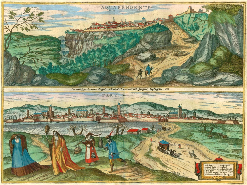
Aquapendente [on sheet with] Tarvisi 1596-1640
Acquapendente and Tarvisio by Braun and Hogenberg.
[Item number: 24195]
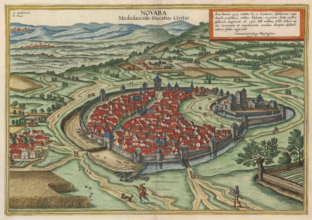
Novara Mediolanensis Ducatus Civitas c. 1625
Novara by Braun and Hogenberg.
[Item number: 24530]