
Emilia-Romagna, by N. Sanson - Covens & Mortier. 1721-41
Covens & Mortier. A Map Publishing House in Amsterdam. 1721-1866.
For almost two centuries, the most significant and crucial Dutch publishing house in commercial cartography was the Amsterdam firm of Covens & Mortier. Concerning quantity, it was the biggest contemporary map-trading house worldwide. They distributed innumerable maps, atlases, globes, and books.
Pieter (Pierre) Mortier (Leiden, 1661 – Amsterdam, 1711)
Nothing is known about the youth of Pieter Mortier. He studied in Paris from 1681 to approximately 1685. He must have come into contact with French 'libraires' and learned the bookselling trade there. In 1685, he returned to Amsterdam and opened a small bookshop. He joined the Book, Art Sellers' and Printers' Guild in the same year.
Pieter sold books in Dutch and foreign languages, but he also published books on his own, usually in French. His business flourished so much that in 1688, he was forced to rent another house on the Vijgendam.
Pieter Mortier's first privilege for maps was granted by the States of Holland and West Friesland on September 15 1690. It refers to the maps of Sanson that he 'is printing and correcting with great pains and care'.
Pieter began the large-scale publication of maps and atlases. By the beginning of the 18th century, Pieter had become so wealthy that he could purchase three houses in Amsterdam: the Beurssluis, on the Vijgendam, and the Heremietensteeg. He rebuilt the house on the Vijgendam into a large, prestigious house that would serve for over a century as a shop, business, and residential structure for Covens & Mortier's publishing house.
He died on February 13, 1711, after a brief illness. The company continued under Pieter's widow's management, Amelia' s-Gravesande.
After she died in 1719, her son, Cornelis, took over the management for a few years.
On November 20, 1721, a company was founded by Cornelis Mortier and Johannes Covens I. The latter was married the same year to Cornelis's sister. From that year on, the name of :
Covens & Mortier.
Their firm would see a massive expansion in the next 140 years. In 1732, the heirs sold the property to their brother Cornelis and his partner Covens. Their main competitors were Reinier & Josua Ottens and Gerard Valck & Petrus Schenck. After the death of Johannes Covens I (1774), his son Johannes Covens II (1722-1794) entered the business. In 1778, Johannes added a new company name :
J. Covens & Son.
Johannes Covens II was succeeded by his son Cornelis Covens (1764-1825), who, in turn, brought Peter Mortier IV, the great-grandson of Petrus Mortier I, into the business. The name was from 1794 to 1866:
Mortier, Covens & Son.
The last Covens in the series was Cornelis Johannes Covens (1806-1880).
Covens & Mortier had a large stock of atlases and maps, including Delisle, Jaillot, Johannes Janssonius, Sanson, and Claes Jansz. Visscher, Nicolaas Visscher, and Frederik de Wit. For decades, an impressive number of atlases came from the press.
SANSON FAMILY
Nicolas Sanson (1600-1667) - Guillaume Sanson (1633-1703) - Pierre Moullart-Sanson (? -1730)
Originally from Abbeville, Nicolas I Sanson showed a keen interest in historical geography. He was still very young; he published a map of ancient Gaul and two treatises, Britannia and Portus Itius on Abbeville and Boulogne's origins. His meeting with Melchior Tavernier was decisive: it prompted him to give up his duties as a military engineer in Picardy and devote himself to engraved cartography.
At the same time, Sanson had drawn up the outline of modern France. He got the help of Tavernier, who encouraged him to compete with the Dutch map publishers. Tavernier contacted other French cartographers whose works he published.
From 1643, N. Sanson obtained a privilege to publish a work personally, the Princes souverains de l'Italie. Then, in 1644 and 1645, he had his famous geographical tables printed, which significantly contributed to his fame. He also published a series of atlases in quarto of the four continents.
In 1648, N. Sanson associated himself with Mariette to publish atlases. From then on, specific maps bore his name and others Mariette's. N. Sanson and Mariette worked together for more than 20 years. After the death of N. Sanson, Mariette acquired the entire fund. Since Mariette only wanted to publish complete atlases, individual maps were no longer sold, and some army generals complained to the king.
The disagreement between the Sanson family and Pierre II Mariette culminated in 1671 when Guillaume Sanson took the case to court. There was no longer any question of collaboration: Guillaume Sanson started working for another publisher, Alexis-Hubert Jaillot.
The Sanson family faced financial difficulties, and in 1692, their cousin, Pierre Moullart-Sanson, bought the entire geographic fund from his uncles and aunt. Pierre Moullart-Sanson was the son of Françoise Sanson (third child of Nicolas) and Pierre Moullart. He restarted the publishing of Sanson's world atlas, and in 1704 he acquired a privilege for publishing all the works of Nicolas and Guillaume Sanson, which continued to be published until 1730.
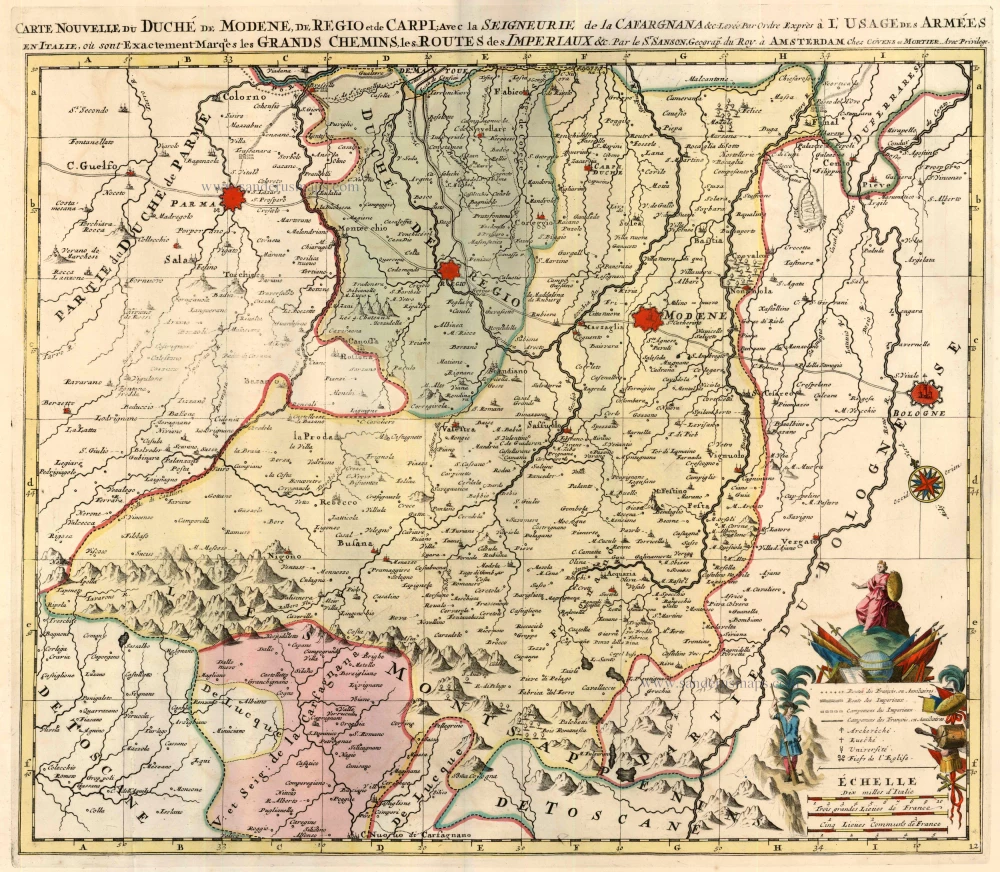
Carte Nouvelle du Duche de Modene, de Regio et de Carpi; avec la Seigneurie de la Cafargnana
Item Number: 23558 Authenticity Guarantee
Category: Antique maps > Europe > Italy
Old, antique map of Emilia_Romagna by N. Sanson - Covens & Mortier.
Title: Carte Nouvelle du Duche de Modene, de Regio et de Carpi; avec la Seigneurie de la Cafargnana.
Oriented to the northeast.
Cartographer: Sanson.
Date: 1721-41.
Copper engraving, printed on paper.
Size (not including margins): 510 x 580mm (20.08 x 22.83 inches).
Verso: Blank.
Condition: Old coloured, excellent.
Condition Rating: A.
From: Composite Atlas. Amsterdam, Covens & Mortier, 1721-41.
Covens & Mortier. A Map Publishing House in Amsterdam. 1721-1866.
For almost two centuries, the most significant and crucial Dutch publishing house in commercial cartography was the Amsterdam firm of Covens & Mortier. Concerning quantity, it was the biggest contemporary map-trading house worldwide. They distributed innumerable maps, atlases, globes, and books.
Pieter (Pierre) Mortier (Leiden, 1661 – Amsterdam, 1711)
Nothing is known about the youth of Pieter Mortier. He studied in Paris from 1681 to approximately 1685. He must have come into contact with French 'libraires' and learned the bookselling trade there. In 1685, he returned to Amsterdam and opened a small bookshop. He joined the Book, Art Sellers' and Printers' Guild in the same year.
Pieter sold books in Dutch and foreign languages, but he also published books on his own, usually in French. His business flourished so much that in 1688, he was forced to rent another house on the Vijgendam.
Pieter Mortier's first privilege for maps was granted by the States of Holland and West Friesland on September 15 1690. It refers to the maps of Sanson that he 'is printing and correcting with great pains and care'.
Pieter began the large-scale publication of maps and atlases. By the beginning of the 18th century, Pieter had become so wealthy that he could purchase three houses in Amsterdam: the Beurssluis, on the Vijgendam, and the Heremietensteeg. He rebuilt the house on the Vijgendam into a large, prestigious house that would serve for over a century as a shop, business, and residential structure for Covens & Mortier's publishing house.
He died on February 13, 1711, after a brief illness. The company continued under Pieter's widow's management, Amelia' s-Gravesande.
After she died in 1719, her son, Cornelis, took over the management for a few years.
On November 20, 1721, a company was founded by Cornelis Mortier and Johannes Covens I. The latter was married the same year to Cornelis's sister. From that year on, the name of :
Covens & Mortier.
Their firm would see a massive expansion in the next 140 years. In 1732, the heirs sold the property to their brother Cornelis and his partner Covens. Their main competitors were Reinier & Josua Ottens and Gerard Valck & Petrus Schenck. After the death of Johannes Covens I (1774), his son Johannes Covens II (1722-1794) entered the business. In 1778, Johannes added a new company name :
J. Covens & Son.
Johannes Covens II was succeeded by his son Cornelis Covens (1764-1825), who, in turn, brought Peter Mortier IV, the great-grandson of Petrus Mortier I, into the business. The name was from 1794 to 1866:
Mortier, Covens & Son.
The last Covens in the series was Cornelis Johannes Covens (1806-1880).
Covens & Mortier had a large stock of atlases and maps, including Delisle, Jaillot, Johannes Janssonius, Sanson, and Claes Jansz. Visscher, Nicolaas Visscher, and Frederik de Wit. For decades, an impressive number of atlases came from the press.
SANSON FAMILY
Nicolas Sanson (1600-1667) - Guillaume Sanson (1633-1703) - Pierre Moullart-Sanson (? -1730)
Originally from Abbeville, Nicolas I Sanson showed a keen interest in historical geography. He was still very young; he published a map of ancient Gaul and two treatises, Britannia and Portus Itius on Abbeville and Boulogne's origins. His meeting with Melchior Tavernier was decisive: it prompted him to give up his duties as a military engineer in Picardy and devote himself to engraved cartography.
At the same time, Sanson had drawn up the outline of modern France. He got the help of Tavernier, who encouraged him to compete with the Dutch map publishers. Tavernier contacted other French cartographers whose works he published.
From 1643, N. Sanson obtained a privilege to publish a work personally, the Princes souverains de l'Italie. Then, in 1644 and 1645, he had his famous geographical tables printed, which significantly contributed to his fame. He also published a series of atlases in quarto of the four continents.
In 1648, N. Sanson associated himself with Mariette to publish atlases. From then on, specific maps bore his name and others Mariette's. N. Sanson and Mariette worked together for more than 20 years. After the death of N. Sanson, Mariette acquired the entire fund. Since Mariette only wanted to publish complete atlases, individual maps were no longer sold, and some army generals complained to the king.
The disagreement between the Sanson family and Pierre II Mariette culminated in 1671 when Guillaume Sanson took the case to court. There was no longer any question of collaboration: Guillaume Sanson started working for another publisher, Alexis-Hubert Jaillot.
The Sanson family faced financial difficulties, and in 1692, their cousin, Pierre Moullart-Sanson, bought the entire geographic fund from his uncles and aunt. Pierre Moullart-Sanson was the son of Françoise Sanson (third child of Nicolas) and Pierre Moullart. He restarted the publishing of Sanson's world atlas, and in 1704 he acquired a privilege for publishing all the works of Nicolas and Guillaume Sanson, which continued to be published until 1730.
Related items
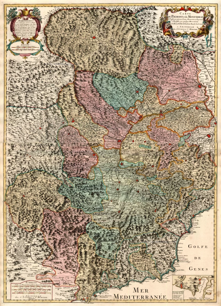
Carte du Piemont et du Monferrat. 1721-41
Piedmonte & Montferrato by Guillaume Delisle, published by Covens & Mortier.
[Item number: 23546]
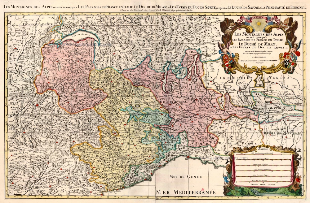
Les Montagnes des Alpes ou sont Remarques les Passages de France en Italie. Le Duche de Milan, et les Estats du Duc de Savoye &c. 1721-41
Northern Italy, by Covens & Mortier.
[Item number: 23547]
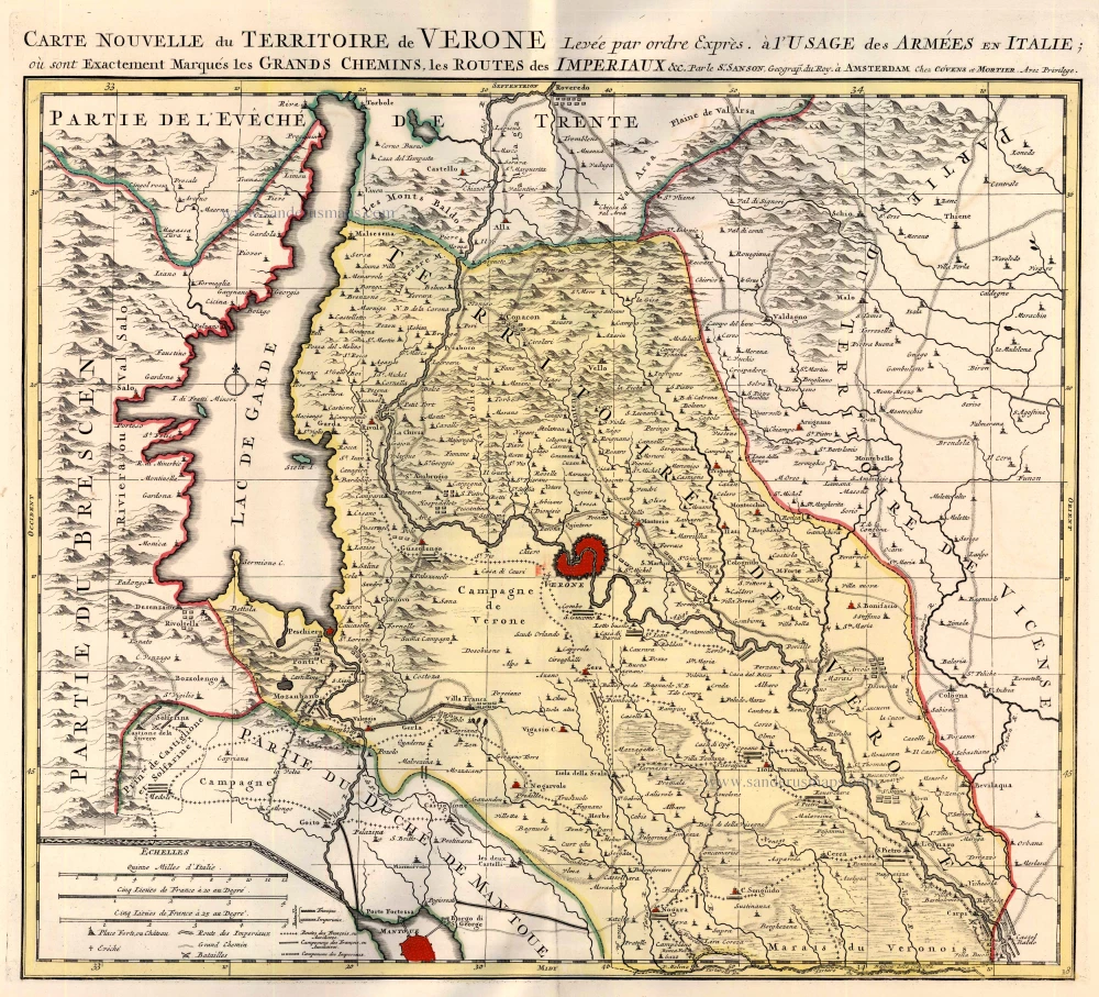
Carte Nouvelle du Territoire de Verone 1721-41
Verona and Garda lake, by Covens & Mortier.
[Item number: 23554]

Carte Nouvelle du Territoire de Vicenza, ou sont Marquees Toutes les Vallees, Cols, Passages et Mines d'Argent 1721-41
Vicenza, by Covens & Mortier.
[Item number: 23555]
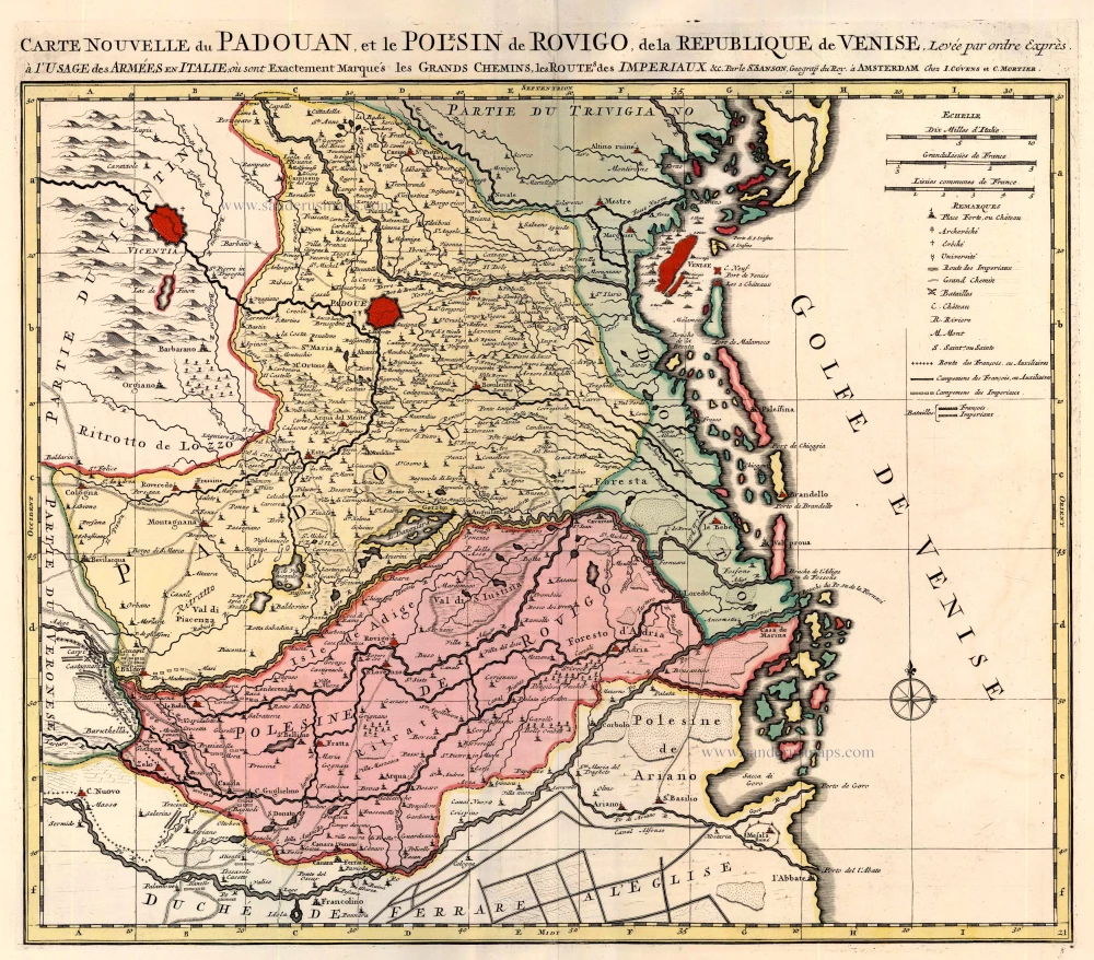
Carte Nouvelle du Padouan, et le Polesin de Rovigo, de la Pepublique de Venise 1721-41
Padova by Covens & Mortier.
[Item number: 23556]
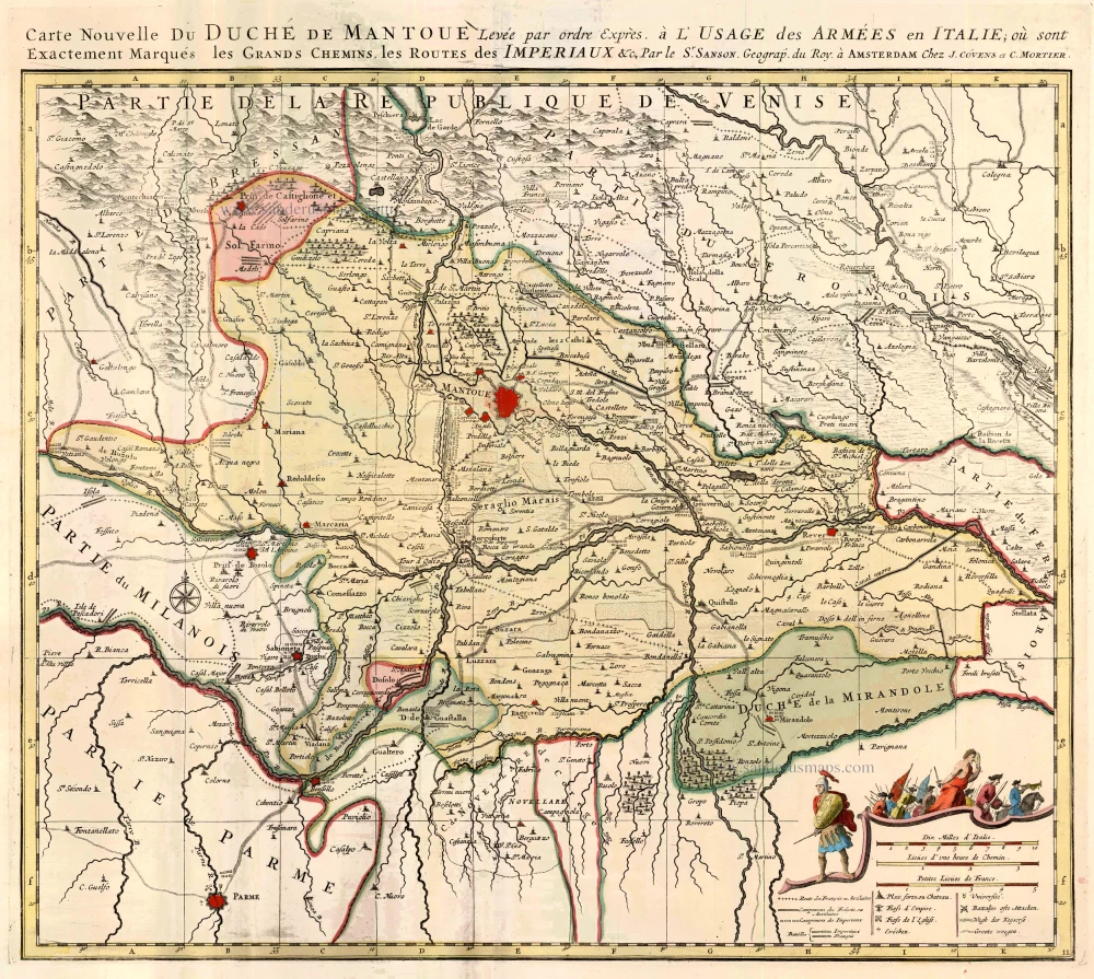
Carte Nouvelle du Duché de Mantoue. 1721-41
Mantova by Covens & Mortier.
[Item number: 23557]
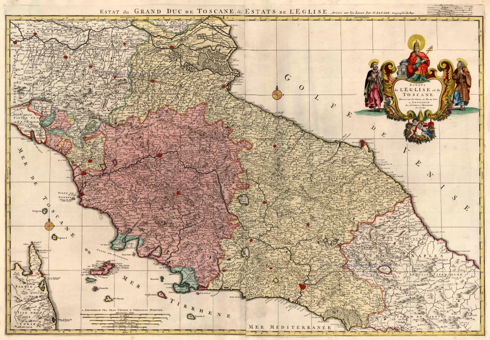
Estats de l'Eglise et de Toscane ... 1721-41
Central Italy, by Covens & Mortier
[Item number: 23559]

Le Cours du Po. 1721-41
Northern Italy, by Covens & Mortier. (5 maps)
[Item number: 23543]
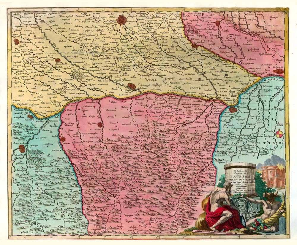
Carte Exacte du Pavesan, Lodesan, Plaisantin Et des Pays circonvoisins. 1713
Pavia, Lodi and Piacenza, by Pieter Van der Aa.
[Item number: 26085]
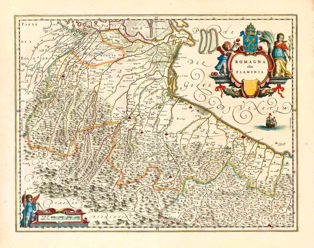
Romagna olim Flaminia. 1640
Romagna, by Willem & Joan Blaeu.
[Item number: 27226]