
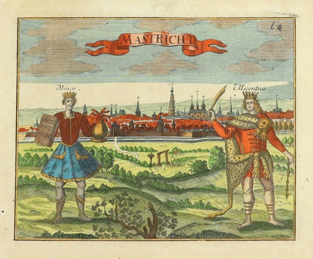
Maastricht, by Georg Braun and Frans Hogenberg. 1597
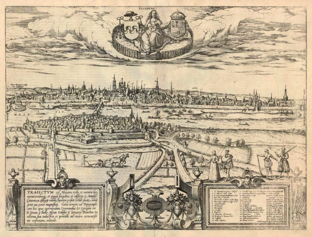
TRANSLATION CARTOUCHE LEFT: Maastricht, a city that is well known because of its natural position, its fortifications, the size of its population, its buildings and great collegiate foundations, reveals itself as a double city joined by a magnificent bridge.
COMMENTARY BY BRAUN (on verso): "Tricht is a large city on both sides of the Meuse, joined by a fine stone bridge with ten arches. The part of the city that lies on the east bank is called Wyck. The city is subject in part to the bishop of Liège and in part to the Duke of Brabant, who is currently the invincible King of Spain, Philip. The main church is the Collegium of St Servatius, where the relics of St Servatius and many other saints are kept."
The Traiectum ad Mosam - "crossing over the Meuse" - gave Maastricht its name. The city is shown in a view from the east over the Wyck and the Meuse from a birds-eye perspective: on the right, above the 160-m-long stone bridge from the 13th century, we see first the Sint-Servaas basilica, on the left to the high tower of the late Gothic Sint-Janskerk (3) and further to the left the late Romanesque Onze-Lieve-Vrouwe church from the 11th/12th centuries (2). From 1284 onwards, Maastricht was under the rule of the Dukes of Brabant and the prince-bishops of Liège. A major historical event was the Spanish conquest and looting of Maastricht during the Dutch Revolt on 1579. (Taschen)
Braun G. & Hogenberg F. and the Civitates Orbis Terrarum.
The Civitates Orbis Terrarum, or the "Braun & Hogenberg", is a six-volume town atlas and the most excellent book of town views and plans ever published: 363 engravings, sometimes beautifully coloured. It was one of the best-selling works in the last quarter of the 16th century. Georg Braun wrote the text accompanying the plans and views on the verso. Many plates were engraved after the original drawings of a professional artist, a professional artist, Joris Hoefnagel (1542-1600). The first volume was published in Latin in 1572, and the sixth in 1617. Frans Hogenberg created the tables for volumes I through IV, and Simon van den Neuwel made those for volumes V and VI. Other contributors were cartographers Daniel Freese and Heinrich Rantzau. Works by Jacob van Deventer, Sebastian Münster, and Johannes Stumpf were also used. Translations appeared in German and French.
Following the original publication of Volume 1 of the Civitates in 1572, seven further editions of 1575, 1577, 1582, 1588, 1593, 1599 and 1612 can be identified. Vol.2, first issued in 1575, was followed by further editions in 1597 and 1612. The subsequent volumes appeared in 1581, 1588, 1593, 1599 and 1606. The German translation of the first volume appeared from 1574 on, and the French edition from 1575 on.
Several printers were involved: Theodor Graminaeus, Heinrich von Aich, Gottfried von Kempen, Johannis Sinniger, Bertram Buchholtz and Peter von Brachel, who all worked in Cologne.
Georg Braun (1541-1622)
Georg Braun was born in Cologne in 1541. After his studies in Cologne, he entered the Jesuit Order as a novice. 1561, he obtained his bachelor's degree, and in 1562, he received his Magister Artium. Although he left the Jesuit Order, he studied theology, gaining a licentiate in theology.
Frans Hogenberg (1535-1590)
Frans Hogenberg was a Flemish and German painter, engraver, and mapmaker. He was born in Mechelen as the son of Nicolaas Hogenberg.
By the end of the 1560s, Frans Hogenberg was employed upon Abraham Ortelius's Theatrum Orbis Terrarum, published in 1570; he is named an engraver of numerous maps. In 1568, he was banned from Antwerp by the Duke of Alva and travelled to London, where he stayed a few years before emigrating to Cologne. He immediately embarked on his two most important works, the Civitates, published in 1572 and the Geschichtsblätter, which appeared in several series from 1569 until about 1587.
Thanks to large-scale projects like the Geschichtsblätter and the Civitates, Hogenberg's social circumstances improved with each passing year. He died as a wealthy man in Cologne in 1590.
Traiectum ad Mosam, urbs et natura loci, ...
Item Number: 24030 Authenticity Guarantee
Category: Antique maps > Europe > The Netherlands - Cities
Antique map - panoramic view of Maastricht by Braun and Hogenberg,
With a key to locations.
Date of the first edition: 1581
Date of this map: 1597
Copper engraving
Size: 37 x 39.5cm (14.4 x 15.4 inches)
Verso text: Latin
Condition: Uncoloured, excellent.
Condition Rating: A
References: Van der Krogt 4, 2533; Taschen, Braun and Hogenberg, p.160.
From: Civitates Orbis Terrarum, ... Part 2: De Praecipuis, Totius Universi Urbibus, Liber Secundus. Köln, Bertram Buchholz, 1597. (Van der Krogt 4, 41:1.2)
TRANSLATION CARTOUCHE LEFT: Maastricht, a city that is well known because of its natural position, its fortifications, the size of its population, its buildings and great collegiate foundations, reveals itself as a double city joined by a magnificent bridge.
COMMENTARY BY BRAUN (on verso): "Tricht is a large city on both sides of the Meuse, joined by a fine stone bridge with ten arches. The part of the city that lies on the east bank is called Wyck. The city is subject in part to the bishop of Liège and in part to the Duke of Brabant, who is currently the invincible King of Spain, Philip. The main church is the Collegium of St Servatius, where the relics of St Servatius and many other saints are kept."
The Traiectum ad Mosam - "crossing over the Meuse" - gave Maastricht its name. The city is shown in a view from the east over the Wyck and the Meuse from a birds-eye perspective: on the right, above the 160-m-long stone bridge from the 13th century, we see first the Sint-Servaas basilica, on the left to the high tower of the late Gothic Sint-Janskerk (3) and further to the left the late Romanesque Onze-Lieve-Vrouwe church from the 11th/12th centuries (2). From 1284 onwards, Maastricht was under the rule of the Dukes of Brabant and the prince-bishops of Liège. A major historical event was the Spanish conquest and looting of Maastricht during the Dutch Revolt on 1579. (Taschen)
Braun G. & Hogenberg F. and the Civitates Orbis Terrarum.
The Civitates Orbis Terrarum, or the "Braun & Hogenberg", is a six-volume town atlas and the most excellent book of town views and plans ever published: 363 engravings, sometimes beautifully coloured. It was one of the best-selling works in the last quarter of the 16th century. Georg Braun wrote the text accompanying the plans and views on the verso. Many plates were engraved after the original drawings of a professional artist, a professional artist, Joris Hoefnagel (1542-1600). The first volume was published in Latin in 1572, and the sixth in 1617. Frans Hogenberg created the tables for volumes I through IV, and Simon van den Neuwel made those for volumes V and VI. Other contributors were cartographers Daniel Freese and Heinrich Rantzau. Works by Jacob van Deventer, Sebastian Münster, and Johannes Stumpf were also used. Translations appeared in German and French.
Following the original publication of Volume 1 of the Civitates in 1572, seven further editions of 1575, 1577, 1582, 1588, 1593, 1599 and 1612 can be identified. Vol.2, first issued in 1575, was followed by further editions in 1597 and 1612. The subsequent volumes appeared in 1581, 1588, 1593, 1599 and 1606. The German translation of the first volume appeared from 1574 on, and the French edition from 1575 on.
Several printers were involved: Theodor Graminaeus, Heinrich von Aich, Gottfried von Kempen, Johannis Sinniger, Bertram Buchholtz and Peter von Brachel, who all worked in Cologne.
Georg Braun (1541-1622)
Georg Braun was born in Cologne in 1541. After his studies in Cologne, he entered the Jesuit Order as a novice. 1561, he obtained his bachelor's degree, and in 1562, he received his Magister Artium. Although he left the Jesuit Order, he studied theology, gaining a licentiate in theology.
Frans Hogenberg (1535-1590)
Frans Hogenberg was a Flemish and German painter, engraver, and mapmaker. He was born in Mechelen as the son of Nicolaas Hogenberg.
By the end of the 1560s, Frans Hogenberg was employed upon Abraham Ortelius's Theatrum Orbis Terrarum, published in 1570; he is named an engraver of numerous maps. In 1568, he was banned from Antwerp by the Duke of Alva and travelled to London, where he stayed a few years before emigrating to Cologne. He immediately embarked on his two most important works, the Civitates, published in 1572 and the Geschichtsblätter, which appeared in several series from 1569 until about 1587.
Thanks to large-scale projects like the Geschichtsblätter and the Civitates, Hogenberg's social circumstances improved with each passing year. He died as a wealthy man in Cologne in 1590.
Related items
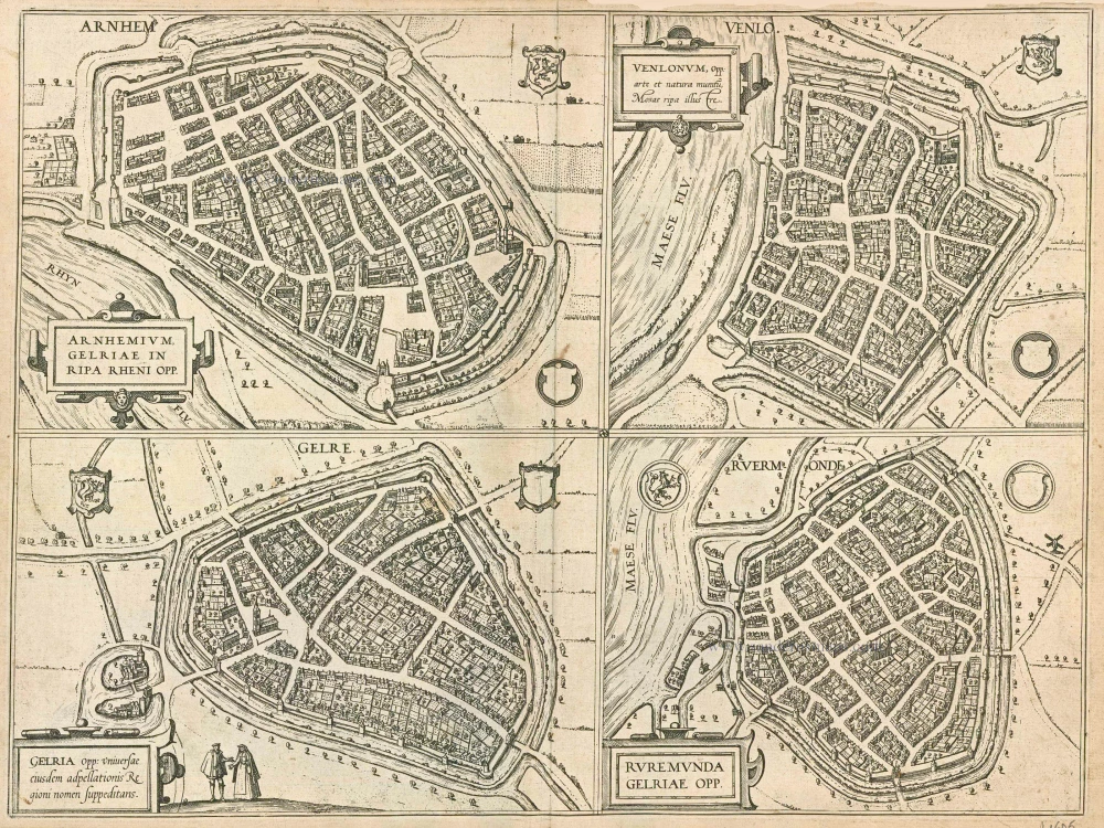
Arnhemium (on sheet with) Venlonum (and) Gelria (and) Ruremunda. 1581-88
Arnhem, Venlo, Gelre and Roermond, by Georg Braun and Frans Hogenberg.
[Item number: 21605]

Urbis Campensis ad Isalam Fluvium Icon. 1581-88
Kampen, by Georg Braun and Frans Hogenberg.
[Item number: 22215]
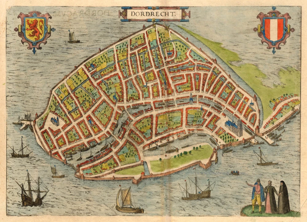
Dordrecht. 1581
Dordrecht, by Braun & Hogenberg
[Item number: 18009]
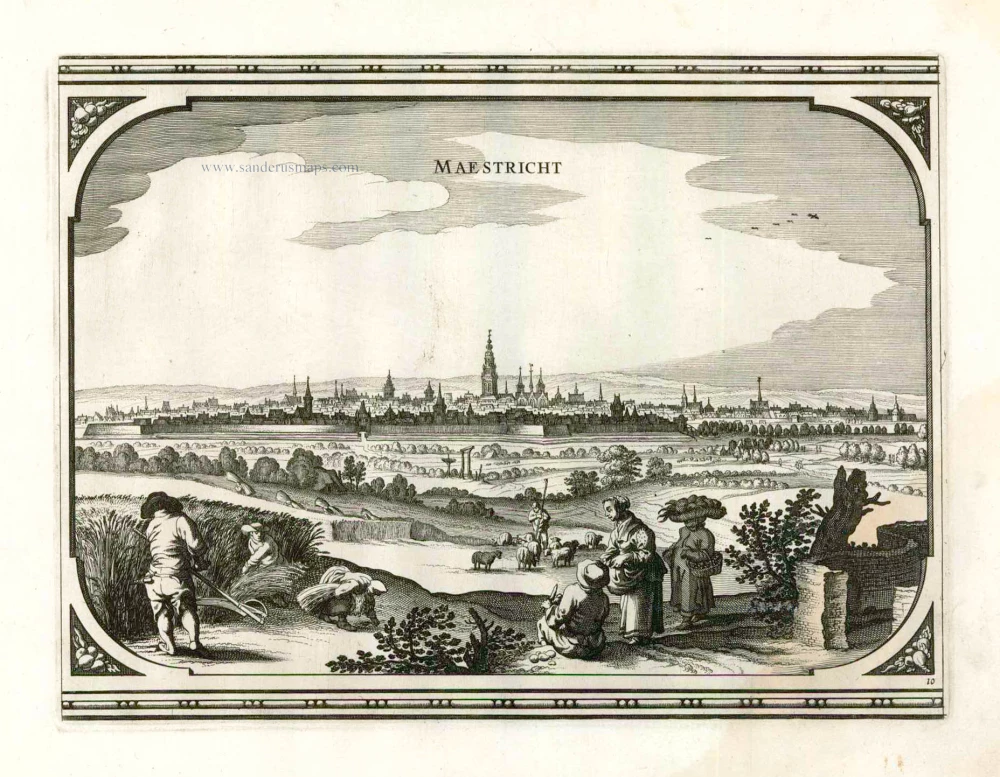
Maestricht. 1656
Maastricht, by Visscher N. - Schut P.H.
[Item number: 25378]
Mastricht 1721-33
Maastricht by David Fassmann.
[Item number: 28167]