
Zwolle, by Braun and Hogenberg. 1599
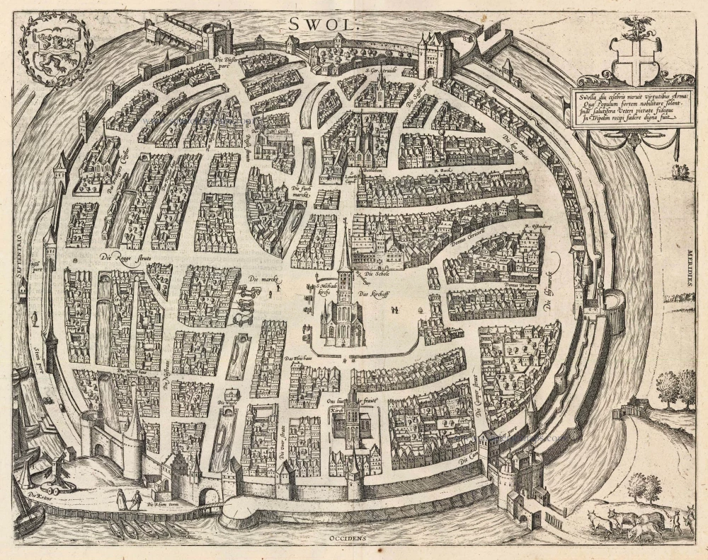
TRANSLATION OF CARTOUCHE TEXT: Zwolle, long famous, earned through its valour arms that usually ennoble brave people. Hence it was worthy of admission into the Three-City League in ancient contractual fidelity.
COMMENTARY BY BRAUN: "Of the eight allied cities of the upper reaches of the IJssel, Zwolle is the most magnificent and, above all, also an imperial city. It possesses three monasteries, one Augustinian, the other Dominican, and the third belonging to the Brethren of the Common Life ("Broeders van het Gemene Leven"), as they are called. There are also four nunneries. There is also a school here, which has produced countless highly learned men."
This bird's-eye plan shows Zwolle's canals and solid city gates from the west. The houses within their blocks are very close and appear compressed, whereas the squares and streets seem unnaturally broad. The Grote Kerk (S. Michielskerk) and, directly beneath it, the Onze-Lieve-Vrouwe basilica are among the most prominent buildings in the illustration. The basilica tower is known as the Peperbus after its shape. Visible top right is the Sassenport, Zwolle's sole surviving city gate and today the town's landmark. On the left-hand side of the city lies the Dominican monastery, which was endowed in 1465. (Taschen)
Braun G. & Hogenberg F. and the Civitates Orbis Terrarum.
The Civitates Orbis Terrarum, or the "Braun & Hogenberg", is a six-volume town atlas and the most excellent book of town views and plans ever published: 363 engravings, sometimes beautifully coloured. It was one of the best-selling works in the last quarter of the 16th century. Georg Braun wrote the text accompanying the plans and views on the verso. Many plates were engraved after the original drawings of a professional artist, a professional artist, Joris Hoefnagel (1542-1600). The first volume was published in Latin in 1572, and the sixth in 1617. Frans Hogenberg created the tables for volumes I through IV, and Simon van den Neuwel made those for volumes V and VI. Other contributors were cartographers Daniel Freese and Heinrich Rantzau. Works by Jacob van Deventer, Sebastian Münster, and Johannes Stumpf were also used. Translations appeared in German and French.
Following the original publication of Volume 1 of the Civitates in 1572, seven further editions of 1575, 1577, 1582, 1588, 1593, 1599 and 1612 can be identified. Vol.2, first issued in 1575, was followed by further editions in 1597 and 1612. The subsequent volumes appeared in 1581, 1588, 1593, 1599 and 1606. The German translation of the first volume appeared from 1574 on, and the French edition from 1575 on.
Several printers were involved: Theodor Graminaeus, Heinrich von Aich, Gottfried von Kempen, Johannis Sinniger, Bertram Buchholtz and Peter von Brachel, who all worked in Cologne.
Georg Braun (1541-1622)
Georg Braun was born in Cologne in 1541. After his studies in Cologne, he entered the Jesuit Order as a novice. 1561, he obtained his bachelor's degree, and in 1562, he received his Magister Artium. Although he left the Jesuit Order, he studied theology, gaining a licentiate in theology.
Frans Hogenberg (1535-1590)
Frans Hogenberg was a Flemish and German painter, engraver, and mapmaker. He was born in Mechelen as the son of Nicolaas Hogenberg.
By the end of the 1560s, Frans Hogenberg was employed upon Abraham Ortelius's Theatrum Orbis Terrarum, published in 1570; he is named an engraver of numerous maps. In 1568, he was banned from Antwerp by the Duke of Alva and travelled to London, where he stayed a few years before emigrating to Cologne. He immediately embarked on his two most important works, the Civitates, published in 1572 and the Geschichtsblätter, which appeared in several series from 1569 until about 1587.
Thanks to large-scale projects like the Geschichtsblätter and the Civitates, Hogenberg's social circumstances improved with each passing year. He died as a wealthy man in Cologne in 1590.
Swolla diu celebris meruit virtutibus Arma: ...
Item Number: 24050 Authenticity Guarantee
Category: Antique maps > Europe > The Netherlands - Cities
Antique map - bird's-eye view plan of Zwolle by Braun and Hogenberg.
Title: Swolla diu celebris meruit virtutibus Arma: ...
Date of the first edition: 1581.
Date of this map: 1599.
Copper engraving, printed on paper.
Size (not including margins): 335 x 430mm (13.19 x 16.93 inches).
Verso: Latin text.
Condition: Uncoloured, excellent.
Condition Rating: A+.
From: Civitates Orbis Terrarum. Liber tertius. Köln, Bertram Buchholtz, 1599. (Koeman, B&H3)
TRANSLATION OF CARTOUCHE TEXT: Zwolle, long famous, earned through its valour arms that usually ennoble brave people. Hence it was worthy of admission into the Three-City League in ancient contractual fidelity.
COMMENTARY BY BRAUN: "Of the eight allied cities of the upper reaches of the IJssel, Zwolle is the most magnificent and, above all, also an imperial city. It possesses three monasteries, one Augustinian, the other Dominican, and the third belonging to the Brethren of the Common Life ("Broeders van het Gemene Leven"), as they are called. There are also four nunneries. There is also a school here, which has produced countless highly learned men."
This bird's-eye plan shows Zwolle's canals and solid city gates from the west. The houses within their blocks are very close and appear compressed, whereas the squares and streets seem unnaturally broad. The Grote Kerk (S. Michielskerk) and, directly beneath it, the Onze-Lieve-Vrouwe basilica are among the most prominent buildings in the illustration. The basilica tower is known as the Peperbus after its shape. Visible top right is the Sassenport, Zwolle's sole surviving city gate and today the town's landmark. On the left-hand side of the city lies the Dominican monastery, which was endowed in 1465. (Taschen)
Braun G. & Hogenberg F. and the Civitates Orbis Terrarum.
The Civitates Orbis Terrarum, or the "Braun & Hogenberg", is a six-volume town atlas and the most excellent book of town views and plans ever published: 363 engravings, sometimes beautifully coloured. It was one of the best-selling works in the last quarter of the 16th century. Georg Braun wrote the text accompanying the plans and views on the verso. Many plates were engraved after the original drawings of a professional artist, a professional artist, Joris Hoefnagel (1542-1600). The first volume was published in Latin in 1572, and the sixth in 1617. Frans Hogenberg created the tables for volumes I through IV, and Simon van den Neuwel made those for volumes V and VI. Other contributors were cartographers Daniel Freese and Heinrich Rantzau. Works by Jacob van Deventer, Sebastian Münster, and Johannes Stumpf were also used. Translations appeared in German and French.
Following the original publication of Volume 1 of the Civitates in 1572, seven further editions of 1575, 1577, 1582, 1588, 1593, 1599 and 1612 can be identified. Vol.2, first issued in 1575, was followed by further editions in 1597 and 1612. The subsequent volumes appeared in 1581, 1588, 1593, 1599 and 1606. The German translation of the first volume appeared from 1574 on, and the French edition from 1575 on.
Several printers were involved: Theodor Graminaeus, Heinrich von Aich, Gottfried von Kempen, Johannis Sinniger, Bertram Buchholtz and Peter von Brachel, who all worked in Cologne.
Georg Braun (1541-1622)
Georg Braun was born in Cologne in 1541. After his studies in Cologne, he entered the Jesuit Order as a novice. 1561, he obtained his bachelor's degree, and in 1562, he received his Magister Artium. Although he left the Jesuit Order, he studied theology, gaining a licentiate in theology.
Frans Hogenberg (1535-1590)
Frans Hogenberg was a Flemish and German painter, engraver, and mapmaker. He was born in Mechelen as the son of Nicolaas Hogenberg.
By the end of the 1560s, Frans Hogenberg was employed upon Abraham Ortelius's Theatrum Orbis Terrarum, published in 1570; he is named an engraver of numerous maps. In 1568, he was banned from Antwerp by the Duke of Alva and travelled to London, where he stayed a few years before emigrating to Cologne. He immediately embarked on his two most important works, the Civitates, published in 1572 and the Geschichtsblätter, which appeared in several series from 1569 until about 1587.
Thanks to large-scale projects like the Geschichtsblätter and the Civitates, Hogenberg's social circumstances improved with each passing year. He died as a wealthy man in Cologne in 1590.
Related items

Deelft - Delphum Urbs Hollandiae cultissima ab eiusdem nominis fossa vulgo, Delfft appellata. 1582
Delft, by Braun & Hogenberg.
[Item number: 17166]
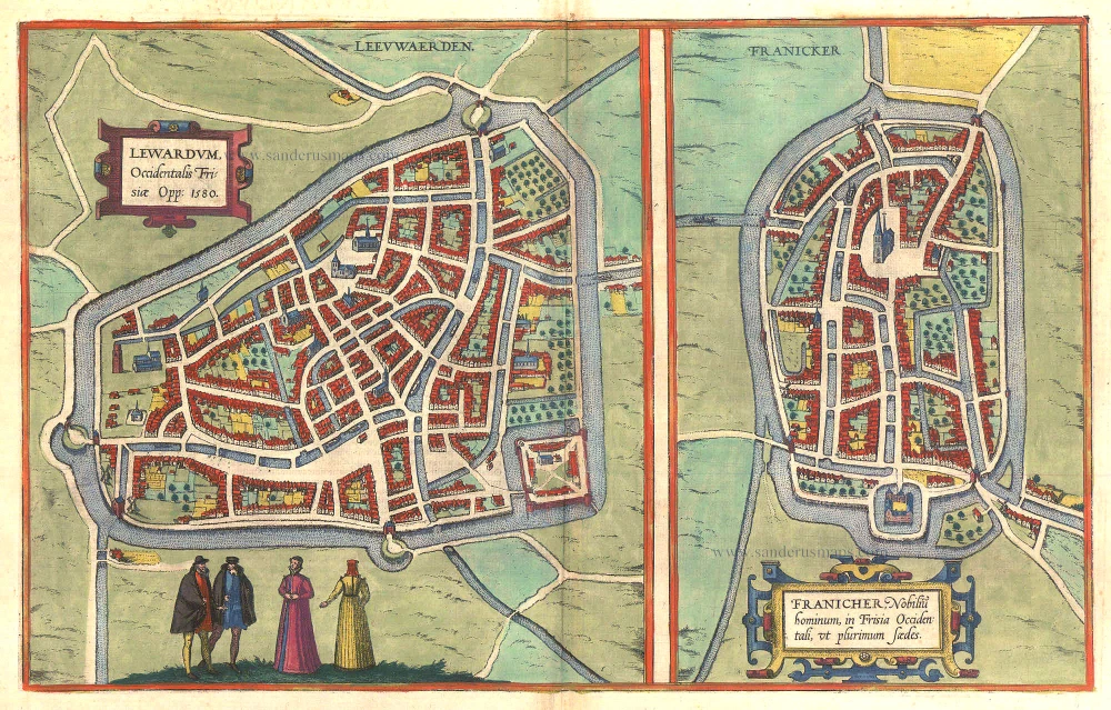
Lewardum. Occidentalis Frisiae Opp: 1580. [on sheet with:] Franicher, Nobiliu hominum, in Frisia Occidentali, ut plurimum saedes. 1581-88
Leeuwarden & Franeker by Braun & Hogenberg.
[Item number: 20439]

Urbis Campensis ad Isalam Fluvium Icon. 1581-88
Kampen, by Georg Braun and Frans Hogenberg.
[Item number: 22215]
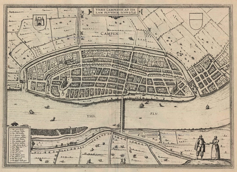
Urbis Campensis ad Isalam Fluvium Icon. 1599
Kampen by Braun and Hogenberg.
[Item number: 24049]