
Flensburg and Itzehoe, by Georg Braun and Frans Hogenberg. 1599

FLENSBURG
COMMENTARY BY BRAUN: "This city lies between high mountains, on the shores of the Baltic Sea, with a harbour stretching into the city with such comfort, depth and safety that every citizen can load and unload ships from his own house. [...] Nearby there is a very fine castle on a hill, which has the same name as the city and which can be seen from far away."
This view from the east of the harbour city at the end of the Flensburg Fjord shows the long merchants' yards that are typical of old Flensburg - front-gabled houses on both sides of the main streets, with shops and behind them storerooms and workshops. The dominating buildings, from left to right, are the Gothic church of St Nicholas and the church of the Holy Spirit, both dating from the 14th century, and the church of St Mary. The 15th century castle of Duburg is on the far right, to the north of the city. In the foreground on the left is the Romanesque church of St John.
ITZEHOE
CARTOUCHE: Itzehoe, a town in flourishing Holstein.
COMMENTARY BY BRAUN: "Itzehoe, a renowned and brave town in Holstein, is admirable because of its good location, harbour, and resulting trade [...]. The Stör, a river full of fish and ships surround it. This rises in the middle of Holstein, flows past several towns [...] and joins the Elbe in the west before finally flowing into the sea."
This view from the northeast shows the favourable position of Itzehoe at the Stör crossing, which can be reached by sea-going merchant ships and where the main trade routes to the north, west and east fork. There was a border fortress here since AD 810, and a settlement grew up in the northern bank of the river, to which a Cistercian nunnery with the Gothic hall church of St Lawrence was added in 1256. Itzehoe was granted a municipal charter and staple rights in 1260. The town expanded around a ducal castle on the southern bank of the river, on an island that may have been created artificially. The town was almost completely destroyed in the Danish-Swedish War in 1657. Today Itzehoe has a population of 34,000 and is a modern commercial town with forests nearby. (Taschen)
Braun G. & Hogenberg F. and the Civitates Orbis Terrarum.
The Civitates Orbis Terrarum, or the "Braun & Hogenberg", is a six-volume town atlas and the most excellent book of town views and plans ever published: 363 engravings, sometimes beautifully coloured. It was one of the best-selling works in the last quarter of the 16th century. Georg Braun wrote the text accompanying the plans and views on the verso. Many plates were engraved after the original drawings of a professional artist, a professional artist, Joris Hoefnagel (1542-1600). The first volume was published in Latin in 1572, and the sixth in 1617. Frans Hogenberg created the tables for volumes I through IV, and Simon van den Neuwel made those for volumes V and VI. Other contributors were cartographers Daniel Freese and Heinrich Rantzau. Works by Jacob van Deventer, Sebastian Münster, and Johannes Stumpf were also used. Translations appeared in German and French.
Following the original publication of Volume 1 of the Civitates in 1572, seven further editions of 1575, 1577, 1582, 1588, 1593, 1599 and 1612 can be identified. Vol.2, first issued in 1575, was followed by further editions in 1597 and 1612. The subsequent volumes appeared in 1581, 1588, 1593, 1599 and 1606. The German translation of the first volume appeared from 1574 on, and the French edition from 1575 on.
Several printers were involved: Theodor Graminaeus, Heinrich von Aich, Gottfried von Kempen, Johannis Sinniger, Bertram Buchholtz and Peter von Brachel, who all worked in Cologne.
Georg Braun (1541-1622)
Georg Braun was born in Cologne in 1541. After his studies in Cologne, he entered the Jesuit Order as a novice. 1561, he obtained his bachelor's degree, and in 1562, he received his Magister Artium. Although he left the Jesuit Order, he studied theology, gaining a licentiate in theology.
Frans Hogenberg (1535-1590)
Frans Hogenberg was a Flemish and German painter, engraver, and mapmaker. He was born in Mechelen as the son of Nicolaas Hogenberg.
By the end of the 1560s, Frans Hogenberg was employed upon Abraham Ortelius's Theatrum Orbis Terrarum, published in 1570; he is named an engraver of numerous maps. In 1568, he was banned from Antwerp by the Duke of Alva and travelled to London, where he stayed a few years before emigrating to Cologne. He immediately embarked on his two most important works, the Civitates, published in 1572 and the Geschichtsblätter, which appeared in several series from 1569 until about 1587.
Thanks to large-scale projects like the Geschichtsblätter and the Civitates, Hogenberg's social circumstances improved with each passing year. He died as a wealthy man in Cologne in 1590.
Flensburgum [on sheet with:] Itzhoa Florentissimae Holsatiæ Op.
Item Number: 24104 Authenticity Guarantee
Category: Antique maps > Europe > Germany - Cities
Old, antique bird’s-eye view plan of Flensburg and Itzehoe, by Georg Braun and Frans Hogenberg.
Title: Flensburgum [on sheet with:] Itzhoa Florentissimae Holsatiæ Op.
Date of the first edition: 1588.
Date of this map: 1599.
Copper engraving, printed on paper.
Size (not including margins): 343 x 486mm (13.5 x 19.13 inches).
Verso: Latin text.
Condition: Original coloured, excellent.
Condition Rating: A+.
From: Liber quartus Urbium Praecipuarum totius Mundi. Cologne, Bertram Buchholtz, 1599. (Van der Krogt 4, 41:1.4(1599))
FLENSBURG
COMMENTARY BY BRAUN: "This city lies between high mountains, on the shores of the Baltic Sea, with a harbour stretching into the city with such comfort, depth and safety that every citizen can load and unload ships from his own house. [...] Nearby there is a very fine castle on a hill, which has the same name as the city and which can be seen from far away."
This view from the east of the harbour city at the end of the Flensburg Fjord shows the long merchants' yards that are typical of old Flensburg - front-gabled houses on both sides of the main streets, with shops and behind them storerooms and workshops. The dominating buildings, from left to right, are the Gothic church of St Nicholas and the church of the Holy Spirit, both dating from the 14th century, and the church of St Mary. The 15th century castle of Duburg is on the far right, to the north of the city. In the foreground on the left is the Romanesque church of St John.
ITZEHOE
CARTOUCHE: Itzehoe, a town in flourishing Holstein.
COMMENTARY BY BRAUN: "Itzehoe, a renowned and brave town in Holstein, is admirable because of its good location, harbour, and resulting trade [...]. The Stör, a river full of fish and ships surround it. This rises in the middle of Holstein, flows past several towns [...] and joins the Elbe in the west before finally flowing into the sea."
This view from the northeast shows the favourable position of Itzehoe at the Stör crossing, which can be reached by sea-going merchant ships and where the main trade routes to the north, west and east fork. There was a border fortress here since AD 810, and a settlement grew up in the northern bank of the river, to which a Cistercian nunnery with the Gothic hall church of St Lawrence was added in 1256. Itzehoe was granted a municipal charter and staple rights in 1260. The town expanded around a ducal castle on the southern bank of the river, on an island that may have been created artificially. The town was almost completely destroyed in the Danish-Swedish War in 1657. Today Itzehoe has a population of 34,000 and is a modern commercial town with forests nearby. (Taschen)
Braun G. & Hogenberg F. and the Civitates Orbis Terrarum.
The Civitates Orbis Terrarum, or the "Braun & Hogenberg", is a six-volume town atlas and the most excellent book of town views and plans ever published: 363 engravings, sometimes beautifully coloured. It was one of the best-selling works in the last quarter of the 16th century. Georg Braun wrote the text accompanying the plans and views on the verso. Many plates were engraved after the original drawings of a professional artist, a professional artist, Joris Hoefnagel (1542-1600). The first volume was published in Latin in 1572, and the sixth in 1617. Frans Hogenberg created the tables for volumes I through IV, and Simon van den Neuwel made those for volumes V and VI. Other contributors were cartographers Daniel Freese and Heinrich Rantzau. Works by Jacob van Deventer, Sebastian Münster, and Johannes Stumpf were also used. Translations appeared in German and French.
Following the original publication of Volume 1 of the Civitates in 1572, seven further editions of 1575, 1577, 1582, 1588, 1593, 1599 and 1612 can be identified. Vol.2, first issued in 1575, was followed by further editions in 1597 and 1612. The subsequent volumes appeared in 1581, 1588, 1593, 1599 and 1606. The German translation of the first volume appeared from 1574 on, and the French edition from 1575 on.
Several printers were involved: Theodor Graminaeus, Heinrich von Aich, Gottfried von Kempen, Johannis Sinniger, Bertram Buchholtz and Peter von Brachel, who all worked in Cologne.
Georg Braun (1541-1622)
Georg Braun was born in Cologne in 1541. After his studies in Cologne, he entered the Jesuit Order as a novice. 1561, he obtained his bachelor's degree, and in 1562, he received his Magister Artium. Although he left the Jesuit Order, he studied theology, gaining a licentiate in theology.
Frans Hogenberg (1535-1590)
Frans Hogenberg was a Flemish and German painter, engraver, and mapmaker. He was born in Mechelen as the son of Nicolaas Hogenberg.
By the end of the 1560s, Frans Hogenberg was employed upon Abraham Ortelius's Theatrum Orbis Terrarum, published in 1570; he is named an engraver of numerous maps. In 1568, he was banned from Antwerp by the Duke of Alva and travelled to London, where he stayed a few years before emigrating to Cologne. He immediately embarked on his two most important works, the Civitates, published in 1572 and the Geschichtsblätter, which appeared in several series from 1569 until about 1587.
Thanks to large-scale projects like the Geschichtsblätter and the Civitates, Hogenberg's social circumstances improved with each passing year. He died as a wealthy man in Cologne in 1590.
Related items
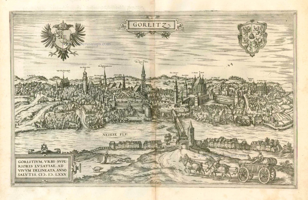
Gorlitz - Gorlitium, Urbs Superioris Lusatiae, ad vivum delineata, Anno Salutis MDLXXV 1576
Gorlitz, by Georg Braun and Frans Hogenberg.
[Item number: 4057]
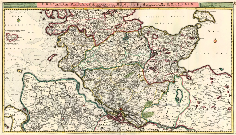
Holsatiae Ducatus vernacule Das Hertzogtum Holstein 1683-1696
Holstein, by N. Visscher.
[Item number: 10961]

Bardum Pomeraniae. 1596
Barth, by Georg Braun and Frans Hogenberg.
[Item number: 23386]
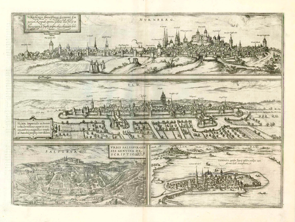
Nurnberga Florentissimum Germaniae Emporium, ... [on sheet with] Ulma Imperialis in Suevia [and] Saltzburg Urbis Salisburgensis Genvina Descriptio [and] Lindaw - Lindoia, Oppidum Imperij insulare, ... 1599
Nürnberg, Ulm, Salzburg, and Lindau, by Georg Braun and Frans Hogenberg.
[Item number: 23926]
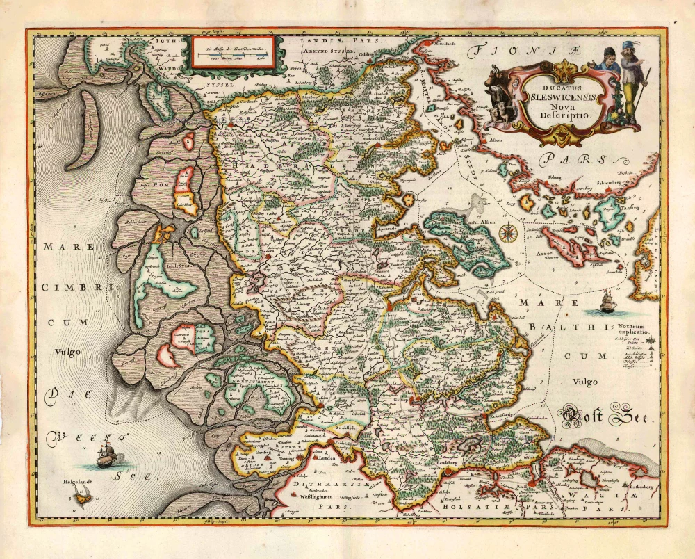
Ducatus Sleswicensis Nova Descriptio. 1666
Schleswig, by Joannes Janssonius.
[Item number: 26765]