
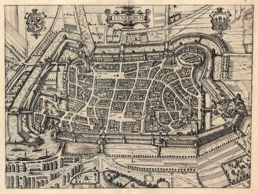
Luneburg, by Georg Braun and Frans Hogenberg. 1596
Braun G. & Hogenberg F. and the Civitates Orbis Terrarum.
The Civitates Orbis Terrarum, or the "Braun & Hogenberg", is a six-volume town atlas and the most excellent book of town views and plans ever published: 363 engravings, sometimes beautifully coloured. It was one of the best-selling works in the last quarter of the 16th century. Georg Braun wrote the text accompanying the plans and views on the verso. Many plates were engraved after the original drawings of a professional artist, a professional artist, Joris Hoefnagel (1542-1600). The first volume was published in Latin in 1572, and the sixth in 1617. Frans Hogenberg created the tables for volumes I through IV, and Simon van den Neuwel made those for volumes V and VI. Other contributors were cartographers Daniel Freese and Heinrich Rantzau. Works by Jacob van Deventer, Sebastian Münster, and Johannes Stumpf were also used. Translations appeared in German and French.
Following the original publication of Volume 1 of the Civitates in 1572, seven further editions of 1575, 1577, 1582, 1588, 1593, 1599 and 1612 can be identified. Vol.2, first issued in 1575, was followed by further editions in 1597 and 1612. The subsequent volumes appeared in 1581, 1588, 1593, 1599 and 1606. The German translation of the first volume appeared from 1574 on, and the French edition from 1575 on.
Several printers were involved: Theodor Graminaeus, Heinrich von Aich, Gottfried von Kempen, Johannis Sinniger, Bertram Buchholtz and Peter von Brachel, who all worked in Cologne.
Georg Braun (1541-1622)
Georg Braun was born in Cologne in 1541. After his studies in Cologne, he entered the Jesuit Order as a novice. 1561, he obtained his bachelor's degree, and in 1562, he received his Magister Artium. Although he left the Jesuit Order, he studied theology, gaining a licentiate in theology.
Frans Hogenberg (1535-1590)
Frans Hogenberg was a Flemish and German painter, engraver, and mapmaker. He was born in Mechelen as the son of Nicolaas Hogenberg.
By the end of the 1560s, Frans Hogenberg was employed upon Abraham Ortelius's Theatrum Orbis Terrarum, published in 1570; he is named an engraver of numerous maps. In 1568, he was banned from Antwerp by the Duke of Alva and travelled to London, where he stayed a few years before emigrating to Cologne. He immediately embarked on his two most important works, the Civitates, published in 1572 and the Geschichtsblätter, which appeared in several series from 1569 until about 1587.
Thanks to large-scale projects like the Geschichtsblätter and the Civitates, Hogenberg's social circumstances improved with each passing year. He died as a wealthy man in Cologne in 1590.
Luneborch
Item Number: 24174 Authenticity Guarantee
Category: Antique maps > Europe > Germany - Cities
Antique map - bird's-eye plan of Luneburg by braun and Hogenberg.
COMMENTARY BY BRAUN (on verso): "The city of Lüneburg is very famous in Lower Saxony and takes its name either from the statue of Luna that in ancient time stood on the limestone hill or from the little river that flows past it, now called the Ilmenau but formerly known as the Luno, or Lunaw. [...] In this city there is a remarkable saline spring, a wonderful gift from God the Almighty [...]. It is first mentioned in the chronicles of Emperor Otto I, and as the chronicler Helmond of Bosau has written, Henry the Lion promoted salt production in Lüneburg over the saline springs in Oldesloe, which he ordered to be filled in so that the city of Lüneburg would not be disadvantaged."
This bird's-eye plan shows Lüneburg from the north, i.e. with the main arm of the Ilmenau on the left and thus to the east. Although the fortress perched on the Kalkberg (Kalckberch) to the west had been destroyed as long as 1371, Hogenberg clearly includes it in this view. The limestone Kalckberch - still 80m high in the 16th century - and the salt industry were of prime importance for Lüneburg's economic growth. Salt mining was already in operation at the latest by AD 956, when St Michael's monastery was granted the rights to the duty levied on the city's salt exports. Salt continued to be mined in Lüneburg for over 1,000 years, most intensively from the 11th to the 16th century, when Lüneburg held the salt monopoly in northern Germany. Some 300 labourers worked day and night to extract the "white gold", which was subsequently shipped chiefly from Lübeck. The salt industry was an influencing factor even in the 13th century upon the later granting of the city's charter and in the 15th and early 16th centuries fuelled Lüneburg's greatest economic boom. Production of salt was finally discontinued in 1980 and the saline waters are now exploited only in the thermal baths and spa. (Taschen)
Date of the first edition: 1596
Date of this map: 1596/97
Copper engraving
Size: 35 x 46.5cm (13.7 x 18.1 inches)
Verso text: Latin
Condition: Old coloured.
Condition Rating: A
References: Van der Krogt 4, 2497; Taschen, Braun and Hogenberg, p.396.
From: Urbium Praecipuarum Mundi Theatrum Quintum Auctore Georgio Braunio Agrippinate. Part 5. Köln, 1596/97. (Van der Krogt 4, 41:1.5)
Braun G. & Hogenberg F. and the Civitates Orbis Terrarum.
The Civitates Orbis Terrarum, or the "Braun & Hogenberg", is a six-volume town atlas and the most excellent book of town views and plans ever published: 363 engravings, sometimes beautifully coloured. It was one of the best-selling works in the last quarter of the 16th century. Georg Braun wrote the text accompanying the plans and views on the verso. Many plates were engraved after the original drawings of a professional artist, a professional artist, Joris Hoefnagel (1542-1600). The first volume was published in Latin in 1572, and the sixth in 1617. Frans Hogenberg created the tables for volumes I through IV, and Simon van den Neuwel made those for volumes V and VI. Other contributors were cartographers Daniel Freese and Heinrich Rantzau. Works by Jacob van Deventer, Sebastian Münster, and Johannes Stumpf were also used. Translations appeared in German and French.
Following the original publication of Volume 1 of the Civitates in 1572, seven further editions of 1575, 1577, 1582, 1588, 1593, 1599 and 1612 can be identified. Vol.2, first issued in 1575, was followed by further editions in 1597 and 1612. The subsequent volumes appeared in 1581, 1588, 1593, 1599 and 1606. The German translation of the first volume appeared from 1574 on, and the French edition from 1575 on.
Several printers were involved: Theodor Graminaeus, Heinrich von Aich, Gottfried von Kempen, Johannis Sinniger, Bertram Buchholtz and Peter von Brachel, who all worked in Cologne.
Georg Braun (1541-1622)
Georg Braun was born in Cologne in 1541. After his studies in Cologne, he entered the Jesuit Order as a novice. 1561, he obtained his bachelor's degree, and in 1562, he received his Magister Artium. Although he left the Jesuit Order, he studied theology, gaining a licentiate in theology.
Frans Hogenberg (1535-1590)
Frans Hogenberg was a Flemish and German painter, engraver, and mapmaker. He was born in Mechelen as the son of Nicolaas Hogenberg.
By the end of the 1560s, Frans Hogenberg was employed upon Abraham Ortelius's Theatrum Orbis Terrarum, published in 1570; he is named an engraver of numerous maps. In 1568, he was banned from Antwerp by the Duke of Alva and travelled to London, where he stayed a few years before emigrating to Cologne. He immediately embarked on his two most important works, the Civitates, published in 1572 and the Geschichtsblätter, which appeared in several series from 1569 until about 1587.
Thanks to large-scale projects like the Geschichtsblätter and the Civitates, Hogenberg's social circumstances improved with each passing year. He died as a wealthy man in Cologne in 1590.
Related items

Bardum Pomeraniae. 1596
Barth, by Georg Braun and Frans Hogenberg.
[Item number: 23386]
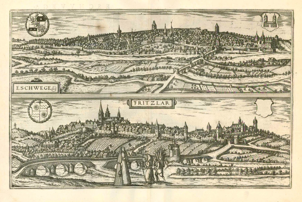
Eschwege [on sheet with] Fritzlar 1599
Eschwege and Fritzlar, by Georg Braun and Frans Hogenberg.
[Item number: 24054]
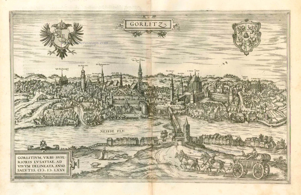
Gorlitz - Gorlitium, Urbs Superioris Lusatiae, ad vivum delineata, Anno Salutis MDLXXV 1576
Gorlitz, by Georg Braun and Frans Hogenberg.
[Item number: 4057]
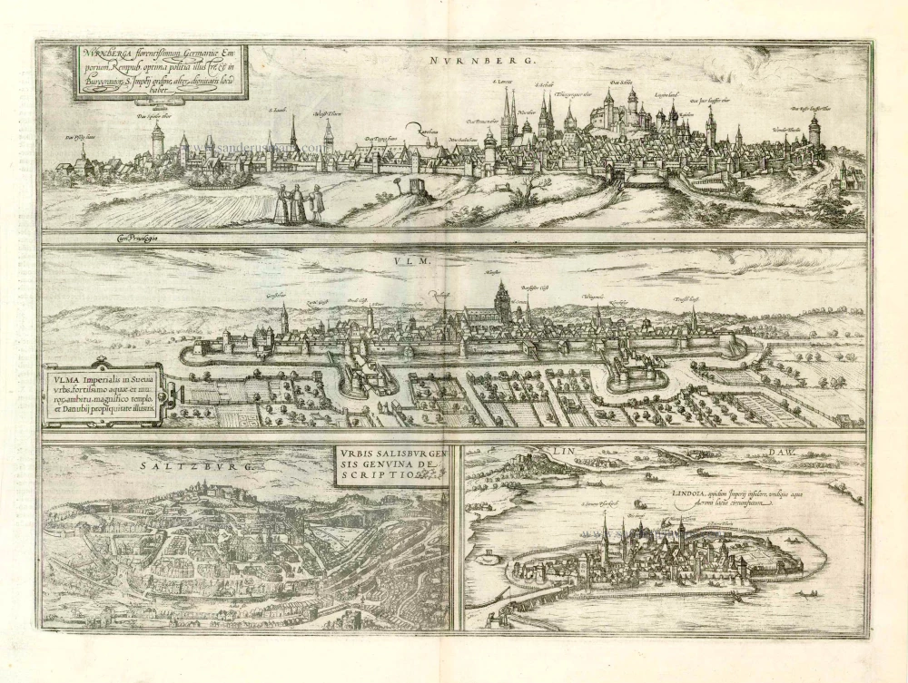
Nurnberga Florentissimum Germaniae Emporium, ... [on sheet with] Ulma Imperialis in Suevia [and] Saltzburg Urbis Salisburgensis Genvina Descriptio [and] Lindaw - Lindoia, Oppidum Imperij insulare, ... 1599
Nürnberg, Ulm, Salzburg, and Lindau, by Georg Braun and Frans Hogenberg.
[Item number: 23926]