
Rare
Alsace, by C.J. Visscher and J. Janssonius. 1630
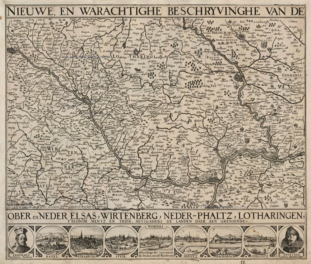
This map of the Alsace consists of two plates. The larger plate (34 x 50 cm) is the left plate of Van den Keere's map of the Rhine. Visscher used the state with the date 1622. As no changes took place before 1632 (when this date was added) the left plate could have been printed any time between 1622 and 1631. Furthermore, Visscher etched a small plate (8 x 50 cm) with portraits, town views and the continuation of the map title. This small strip was mounted below the large sheet.
The title runs along the upper and lower edges of the map image. In the lower left corner of the map sheet is a simple bar scale, followed by the imprint: CJ Visscher excudebat Gedruckt voor Broer Janss 1622. The bottom border, printed from the smaller plate, contains the continuation of the map title, two portraits and seven town views: LEOPOLDUS Archidux Austriae (portrait); BASEL; STRASBURG; SPEIR; WORMBS, with below the title: Afbeeldinge der voornaemste Steden, aen den Rijnstroom; MENTZ; BACHARACH; COBLENTZ; and ERNESTUS Comes Mansfeldiae (portrait).
The Visscher Family
For nearly a century, the members of the Visscher family were essential art dealers and map publishers in Amsterdam.
Claes Jansz. Visscher, or N.J. Piscator (1587-1652)
Claes Jansz. Vischer bought a house in Amsterdam, 'de gulden Bors', on the crucial Kalverstraat and changed the name into "In de Visscher"; under this title, the shop was to flourish for many years.
He was famous for his engravings and etchings of Dutch landscapes and 'historical scenes', such as sieges, battles, etc. These 'historical scenes' were considered contemporary illustrated news items, especially e.g. that of 'the Eighty Years' War'.
For the publication of his first atlas, he bought copperplates of the atlas Germania Inferior by Pieter van den Keere (1623).
In 1649, he published an atlas entitled Tabularum Geographicarum Contractarum, containing the same maps as Langenes' Caert Thresoor, for which Visscher had only new title pages engraved.
Claes Jansz. Visscher died in 1652. His wife, Neeltjen Florisdr., had already died in 1640. They had seven children, four of whom were still alive at Claes Jansz.'s death. One was Nicolaes Visscher I, who was to continue his father's business.
Nicolaes Visscher I (1618-1679)
Nicolaes Visscher I partnered with his father, continued the business, and stayed on the Kalverstraat 'in de Visscher' till his death.
In about 1657, the first edition of his Atlas Contractus Orbis Terrarum appeared.
Between 1664 and 1677, several editions of his Atlas Contractus appeared without a printed index, for these atlases had no fixed contents but were composed according to the buyer's financial leaping pole.
In May 1664, Nicolaes Visscher was admitted as a member of the Booksellers' Guild of his town. In July 1677, he was granted a patent of the States of Holland and West-Friesland for printing and publishing maps and atlases for 15 years.
After this, he again published an Atlas Contractus with a printed index. At about the same time, he also brought out an Atlas Minor.
Nicolaes Visscher II (1649-1702)
Nicolaes Visscher II inherited the 'shop' from his father. To obtain a new privilege, he applied to the States of Holland and West-Friesland in 1682 for a patent for printing and publishing maps. This patent was granted to him the same year. He moved the firm to the Dam, but it kept the same signboard: "In de Visscher".
Around 1683, he published his first Atlas Minor with a printed index of 91 maps. In 1684, an atlas Germania Inferior appeared. Till 1697, he published another number of atlases. He used his grandfather's (Claes Jansz.) maps less often now and relied more and more on his own.
The wars waged at this time initiated the compilation of maps of the countries where the armies operated. Many war maps were included in the various editions of his Atlas Minor.
After Nicolaes's death, his wife, Elizabeth Verseyl, published all the war maps as an atlas under the title De Stoel des Oorlogs in de Wereld (The seat of war in the world).
The widow of Nicolaes Visscher II (?-1726)
His widow continued the business energetically, and by her hand, under the name of her deceased husband, numerous atlases appeared, e.g., several editions of the Atlas Minor, an Atlas Maior and De Stoel des Oorlogs. The shop enjoyed a high reputation due to the assortment's incredible variety. Not only 'Visscher' maps but also maps of other publishers were obtainable. With the death of Elizabeth Verseyl in 1726, the last descendant died of a great map- and atlas-publishing firm in Amsterdam.
Nieuwe, en Warachtighe Beschryvinghe van de Ober en Neder Elsas, Wirtenberg, Neder-Phaltz, Lotharingen, t'Bisdom Mentz en Trier, mitsgaders de Landen daer aen grensende.
Item Number: 24502 Authenticity Guarantee
Category: Antique maps > Europe > France
Old, antique map of Alsace, by C.J. Visscher and J. Janssonius.
Title: Nieuwe, en Warachtighe Beschryvinghe van de Ober en Neder Elsas, Wirtenberg, Neder-Phaltz, Lotharingen, t'Bisdom Mentz en Trier, mitsgaders de Landen daer aen grensende.
Oriented to the southeast.
Date of the first edition: 1622-1631.
Date of this map: 1630.
Copper engraving, printed on paper.
Size (not including margins): 425 x 500mm (16.73 x 19.69 inches).
Verso: Blank.
Condition: Trimmed to the neatline and pasted on the back of a Hondius Rhine map. Small damage to the portrait of Ernestus.
Condition Rating: B
From: Atlantis Maioris Appendix, Sive Pars Altera, . . . Amstelodami. Sumptibus & typis aeneis Ioannis Ianzonii. MDCXXX. (Van der Krogt 1, 1:202)
This map of the Alsace consists of two plates. The larger plate (34 x 50 cm) is the left plate of Van den Keere's map of the Rhine. Visscher used the state with the date 1622. As no changes took place before 1632 (when this date was added) the left plate could have been printed any time between 1622 and 1631. Furthermore, Visscher etched a small plate (8 x 50 cm) with portraits, town views and the continuation of the map title. This small strip was mounted below the large sheet.
The title runs along the upper and lower edges of the map image. In the lower left corner of the map sheet is a simple bar scale, followed by the imprint: CJ Visscher excudebat Gedruckt voor Broer Janss 1622. The bottom border, printed from the smaller plate, contains the continuation of the map title, two portraits and seven town views: LEOPOLDUS Archidux Austriae (portrait); BASEL; STRASBURG; SPEIR; WORMBS, with below the title: Afbeeldinge der voornaemste Steden, aen den Rijnstroom; MENTZ; BACHARACH; COBLENTZ; and ERNESTUS Comes Mansfeldiae (portrait).
The Visscher Family
For nearly a century, the members of the Visscher family were essential art dealers and map publishers in Amsterdam.
Claes Jansz. Visscher, or N.J. Piscator (1587-1652)
Claes Jansz. Vischer bought a house in Amsterdam, 'de gulden Bors', on the crucial Kalverstraat and changed the name into "In de Visscher"; under this title, the shop was to flourish for many years.
He was famous for his engravings and etchings of Dutch landscapes and 'historical scenes', such as sieges, battles, etc. These 'historical scenes' were considered contemporary illustrated news items, especially e.g. that of 'the Eighty Years' War'.
For the publication of his first atlas, he bought copperplates of the atlas Germania Inferior by Pieter van den Keere (1623).
In 1649, he published an atlas entitled Tabularum Geographicarum Contractarum, containing the same maps as Langenes' Caert Thresoor, for which Visscher had only new title pages engraved.
Claes Jansz. Visscher died in 1652. His wife, Neeltjen Florisdr., had already died in 1640. They had seven children, four of whom were still alive at Claes Jansz.'s death. One was Nicolaes Visscher I, who was to continue his father's business.
Nicolaes Visscher I (1618-1679)
Nicolaes Visscher I partnered with his father, continued the business, and stayed on the Kalverstraat 'in de Visscher' till his death.
In about 1657, the first edition of his Atlas Contractus Orbis Terrarum appeared.
Between 1664 and 1677, several editions of his Atlas Contractus appeared without a printed index, for these atlases had no fixed contents but were composed according to the buyer's financial leaping pole.
In May 1664, Nicolaes Visscher was admitted as a member of the Booksellers' Guild of his town. In July 1677, he was granted a patent of the States of Holland and West-Friesland for printing and publishing maps and atlases for 15 years.
After this, he again published an Atlas Contractus with a printed index. At about the same time, he also brought out an Atlas Minor.
Nicolaes Visscher II (1649-1702)
Nicolaes Visscher II inherited the 'shop' from his father. To obtain a new privilege, he applied to the States of Holland and West-Friesland in 1682 for a patent for printing and publishing maps. This patent was granted to him the same year. He moved the firm to the Dam, but it kept the same signboard: "In de Visscher".
Around 1683, he published his first Atlas Minor with a printed index of 91 maps. In 1684, an atlas Germania Inferior appeared. Till 1697, he published another number of atlases. He used his grandfather's (Claes Jansz.) maps less often now and relied more and more on his own.
The wars waged at this time initiated the compilation of maps of the countries where the armies operated. Many war maps were included in the various editions of his Atlas Minor.
After Nicolaes's death, his wife, Elizabeth Verseyl, published all the war maps as an atlas under the title De Stoel des Oorlogs in de Wereld (The seat of war in the world).
The widow of Nicolaes Visscher II (?-1726)
His widow continued the business energetically, and by her hand, under the name of her deceased husband, numerous atlases appeared, e.g., several editions of the Atlas Minor, an Atlas Maior and De Stoel des Oorlogs. The shop enjoyed a high reputation due to the assortment's incredible variety. Not only 'Visscher' maps but also maps of other publishers were obtainable. With the death of Elizabeth Verseyl in 1726, the last descendant died of a great map- and atlas-publishing firm in Amsterdam.
Related items

Aich - Aquisgranum, Urbs Prae Clarissima, Primum, Inter Quatuor Imperii Civitates, Locum Obtinet. 1572
Aachen, by Georg Braun & Frans Hogenberg.
[Item number: 9173]
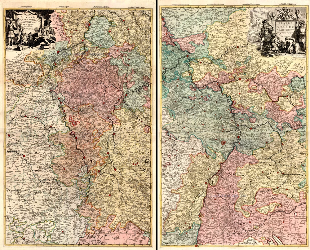
Téâtre de la Guerre sur le Rhein, Moesselle. Mayn, & le Necker, Meuse. Avec les Pais Voisins. 1721-41
The Upper Rhine and surroundings by N. Sanson / Covens & Mortier.
[Item number: 23695]