
Zürich, by Braun & Hogenberg. 1588
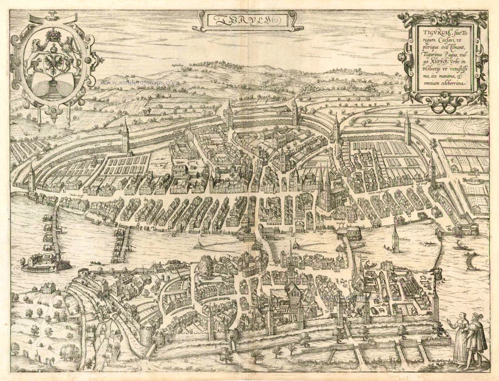
Translation cartouche text: Tigurum, or called Turegum by Caesar; in the opinion of the majority Tigurinus Pagus, in German Zurich; one of the oldest, largest and most famous of Swiss cities.
Commentary by Braun (on verso): "Zurich is one of the oldest cities in Switzerland, built only 16 years after Trier. [...] In the year 1351 the people of Zurich forged an alliance with those of Uri and Schwyz. Readers will learn more about the city from Sebastian Münster, Johannes Stumpff, Josias Simmler, a citizen from Zurich, and from ancient and modern authors, including the most famous geographer of our times, Abraham Ortelius, in his atlas of the world." The engraving clearly shows the two halves of Zurich, separated by the Limmat, and the bridges that link them. The edge of Lake Zurich can be recognized in the lower right-hand corner. In the foreground lies the Old Town, with on the right the twin-towered Romanesque and Gothic Fraumünster, a former Benedictine nunnery, and further left the church of St Peter with a single tower. On a rise in the left half of the picture, lime trees mark the Lindenhof, originally the site of Roman fort and subsequently, in the 9th century, an imperial palace. On the far side of the Limmat, the Wasserkirche lies directly on the river, with behind the Romanesque Grossmünster and on the left the Predigerkirche. The engraving shows the full city wall with its numerous towers, which no longer survive in this form. (Taschen)
Braun G. & Hogenberg F. and the Civitates Orbis Terrarum.
The Civitates Orbis Terrarum, or the "Braun & Hogenberg", is a six-volume town atlas and the most excellent book of town views and plans ever published: 363 engravings, sometimes beautifully coloured. It was one of the best-selling works in the last quarter of the 16th century. Georg Braun wrote the text accompanying the plans and views on the verso. Many plates were engraved after the original drawings of a professional artist, a professional artist, Joris Hoefnagel (1542-1600). The first volume was published in Latin in 1572, and the sixth in 1617. Frans Hogenberg created the tables for volumes I through IV, and Simon van den Neuwel made those for volumes V and VI. Other contributors were cartographers Daniel Freese and Heinrich Rantzau. Works by Jacob van Deventer, Sebastian Münster, and Johannes Stumpf were also used. Translations appeared in German and French.
Following the original publication of Volume 1 of the Civitates in 1572, seven further editions of 1575, 1577, 1582, 1588, 1593, 1599 and 1612 can be identified. Vol.2, first issued in 1575, was followed by further editions in 1597 and 1612. The subsequent volumes appeared in 1581, 1588, 1593, 1599 and 1606. The German translation of the first volume appeared from 1574 on, and the French edition from 1575 on.
Several printers were involved: Theodor Graminaeus, Heinrich von Aich, Gottfried von Kempen, Johannis Sinniger, Bertram Buchholtz and Peter von Brachel, who all worked in Cologne.
Georg Braun (1541-1622)
Georg Braun was born in Cologne in 1541. After his studies in Cologne, he entered the Jesuit Order as a novice. 1561, he obtained his bachelor's degree, and in 1562, he received his Magister Artium. Although he left the Jesuit Order, he studied theology, gaining a licentiate in theology.
Frans Hogenberg (1535-1590)
Frans Hogenberg was a Flemish and German painter, engraver, and mapmaker. He was born in Mechelen as the son of Nicolaas Hogenberg.
By the end of the 1560s, Frans Hogenberg was employed upon Abraham Ortelius's Theatrum Orbis Terrarum, published in 1570; he is named an engraver of numerous maps. In 1568, he was banned from Antwerp by the Duke of Alva and travelled to London, where he stayed a few years before emigrating to Cologne. He immediately embarked on his two most important works, the Civitates, published in 1572 and the Geschichtsblätter, which appeared in several series from 1569 until about 1587.
Thanks to large-scale projects like the Geschichtsblätter and the Civitates, Hogenberg's social circumstances improved with each passing year. He died as a wealthy man in Cologne in 1590.
Zurych - Tigurum, sive Turegum, Caesari, ut Plerique Existimant, Tigurinus Pagus, vulgo Zurych, Urbs in Helvetijs
Item Number: 25148 Authenticity Guarantee
Category: Antique maps > Europe > Switzerland
Old, antique plan of Zürich by Braun & Hogenberg.
Title: Zurych - Tigurum, sive Turegum, Caesari, ut Plerique Existimant, Tigurinus Pagus, vulgo Zurych, Urbs in Helvetijs
Date of the first edition: 1581.
Date of this map: 1588.
Copper engraving, printed on paper.
Size (not including margins): 365 x 485mm (14.37 x 19.09 inches).
Verso: Latin text.
Condition: Uncoloured, excellent.
Condition Rating: A+.
From: Civitates Orbis Terrarum. . Liber tertius. Cologne, Gottfried von Kempen, 1588. (Van der Krogt 4, 41:1.3)
Translation cartouche text: Tigurum, or called Turegum by Caesar; in the opinion of the majority Tigurinus Pagus, in German Zurich; one of the oldest, largest and most famous of Swiss cities.
Commentary by Braun (on verso): "Zurich is one of the oldest cities in Switzerland, built only 16 years after Trier. [...] In the year 1351 the people of Zurich forged an alliance with those of Uri and Schwyz. Readers will learn more about the city from Sebastian Münster, Johannes Stumpff, Josias Simmler, a citizen from Zurich, and from ancient and modern authors, including the most famous geographer of our times, Abraham Ortelius, in his atlas of the world." The engraving clearly shows the two halves of Zurich, separated by the Limmat, and the bridges that link them. The edge of Lake Zurich can be recognized in the lower right-hand corner. In the foreground lies the Old Town, with on the right the twin-towered Romanesque and Gothic Fraumünster, a former Benedictine nunnery, and further left the church of St Peter with a single tower. On a rise in the left half of the picture, lime trees mark the Lindenhof, originally the site of Roman fort and subsequently, in the 9th century, an imperial palace. On the far side of the Limmat, the Wasserkirche lies directly on the river, with behind the Romanesque Grossmünster and on the left the Predigerkirche. The engraving shows the full city wall with its numerous towers, which no longer survive in this form. (Taschen)
Braun G. & Hogenberg F. and the Civitates Orbis Terrarum.
The Civitates Orbis Terrarum, or the "Braun & Hogenberg", is a six-volume town atlas and the most excellent book of town views and plans ever published: 363 engravings, sometimes beautifully coloured. It was one of the best-selling works in the last quarter of the 16th century. Georg Braun wrote the text accompanying the plans and views on the verso. Many plates were engraved after the original drawings of a professional artist, a professional artist, Joris Hoefnagel (1542-1600). The first volume was published in Latin in 1572, and the sixth in 1617. Frans Hogenberg created the tables for volumes I through IV, and Simon van den Neuwel made those for volumes V and VI. Other contributors were cartographers Daniel Freese and Heinrich Rantzau. Works by Jacob van Deventer, Sebastian Münster, and Johannes Stumpf were also used. Translations appeared in German and French.
Following the original publication of Volume 1 of the Civitates in 1572, seven further editions of 1575, 1577, 1582, 1588, 1593, 1599 and 1612 can be identified. Vol.2, first issued in 1575, was followed by further editions in 1597 and 1612. The subsequent volumes appeared in 1581, 1588, 1593, 1599 and 1606. The German translation of the first volume appeared from 1574 on, and the French edition from 1575 on.
Several printers were involved: Theodor Graminaeus, Heinrich von Aich, Gottfried von Kempen, Johannis Sinniger, Bertram Buchholtz and Peter von Brachel, who all worked in Cologne.
Georg Braun (1541-1622)
Georg Braun was born in Cologne in 1541. After his studies in Cologne, he entered the Jesuit Order as a novice. 1561, he obtained his bachelor's degree, and in 1562, he received his Magister Artium. Although he left the Jesuit Order, he studied theology, gaining a licentiate in theology.
Frans Hogenberg (1535-1590)
Frans Hogenberg was a Flemish and German painter, engraver, and mapmaker. He was born in Mechelen as the son of Nicolaas Hogenberg.
By the end of the 1560s, Frans Hogenberg was employed upon Abraham Ortelius's Theatrum Orbis Terrarum, published in 1570; he is named an engraver of numerous maps. In 1568, he was banned from Antwerp by the Duke of Alva and travelled to London, where he stayed a few years before emigrating to Cologne. He immediately embarked on his two most important works, the Civitates, published in 1572 and the Geschichtsblätter, which appeared in several series from 1569 until about 1587.
Thanks to large-scale projects like the Geschichtsblätter and the Civitates, Hogenberg's social circumstances improved with each passing year. He died as a wealthy man in Cologne in 1590.
Related items
1619
Aargau, by Gerard Mercator.
[Item number: 11695]
Constantia, vulgo Costnitz Memorabile Sueuie Opp. [on sheet with:] S. Galli Opp. et Monasterium Helvetiorum, ... 1575-1612
Konstanz - Sankt Gallen by Georg Braun and Frans Hogenberg.
[Item number: 4113]
Argou 1607
Aargau, by J. Hondius.
[Item number: 367]
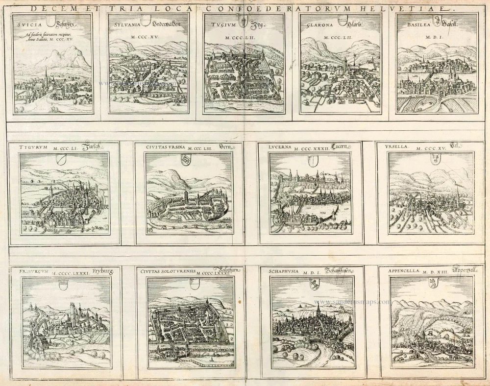
Decem et Tria Loca Confoederatorum Helvetiae. 1572
13 bird's-eye views of Swiss cities by Braun and Hogenberg: Schwyz, Unterwalden, Zug, Glarus, Basel, Zurich, Bern, Lucerne, Uri, Fribourg, Solothurn, Schaffhausen and Appenzell.
[Item number: 21654]
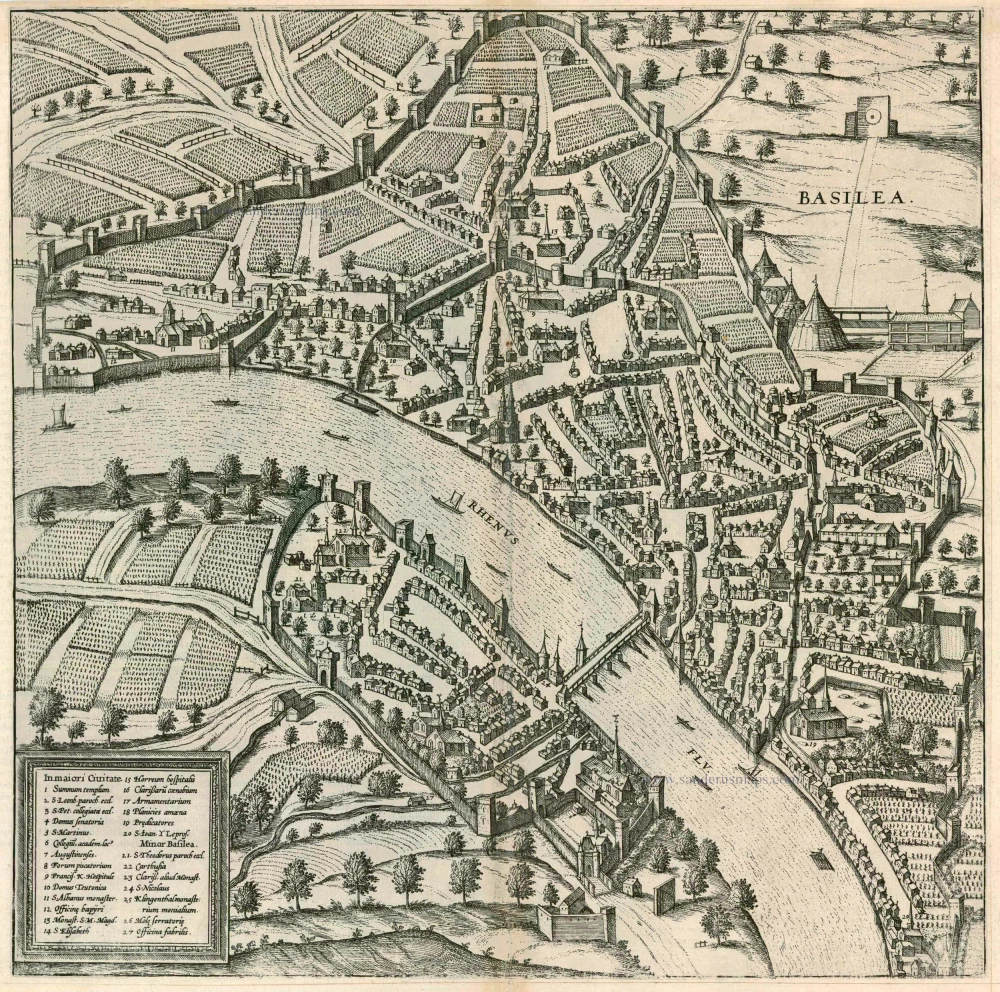
Basilea 1575
Basel, by Georg Braun and Frans Hogenberg.
[Item number: 9248]
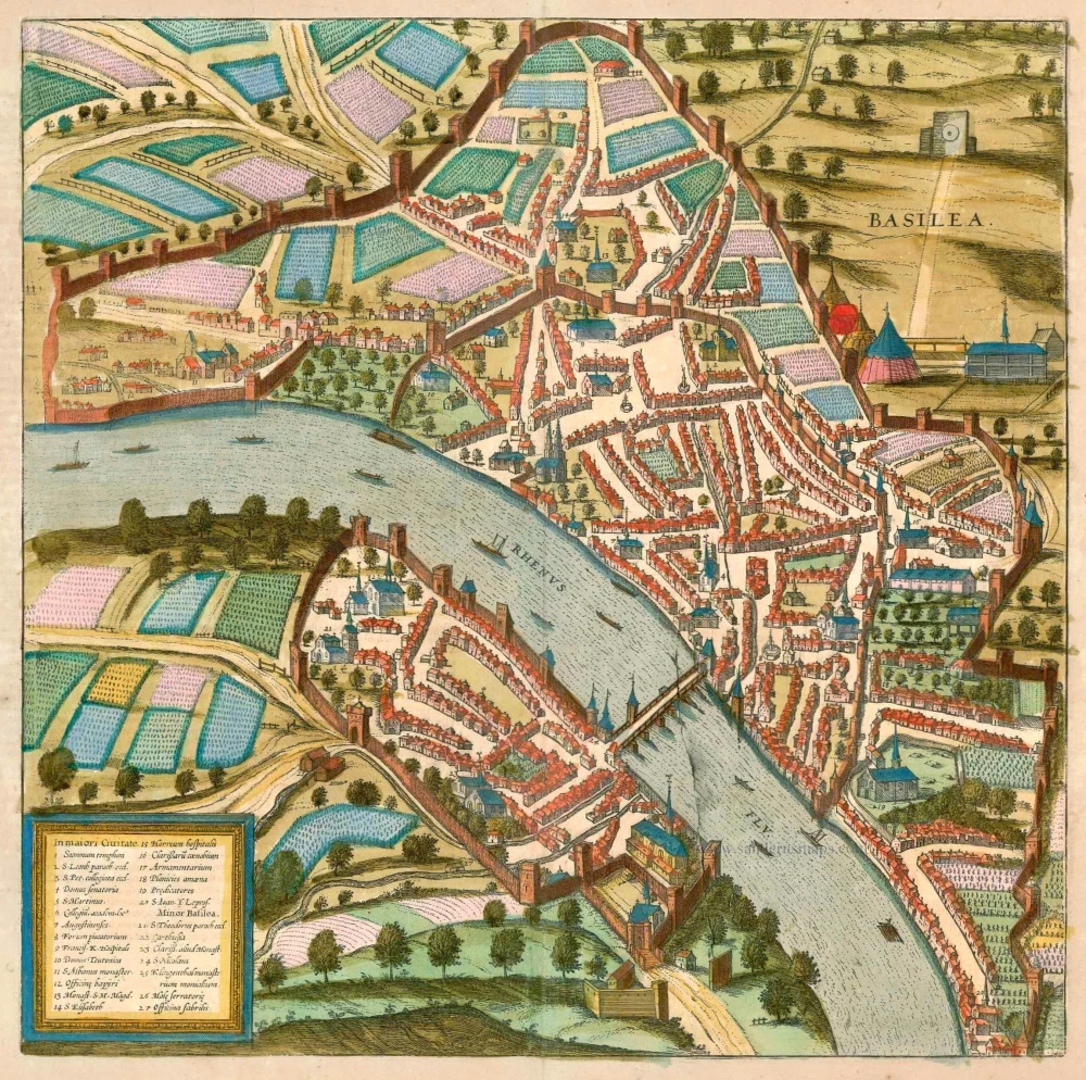
Basilea 1575-1612
Basel, by Georg Braun and Frans Hogenberg.
[Item number: 23280]
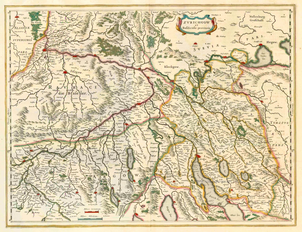
Zurichgow et Basiliensis Provincia 1649-55
Zurich, by Blaeu J.
[Item number: 4769]
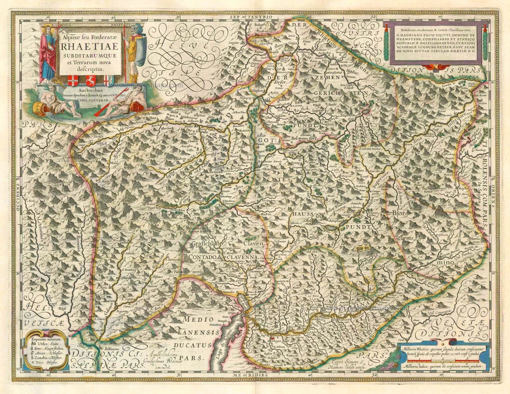
Alpinae seu Foederatae Rhaetiae subditarumque ei Terrarum nova descriptio. 1649-55
Graubünden, by Willem Blaeu.
[Item number: 24544]
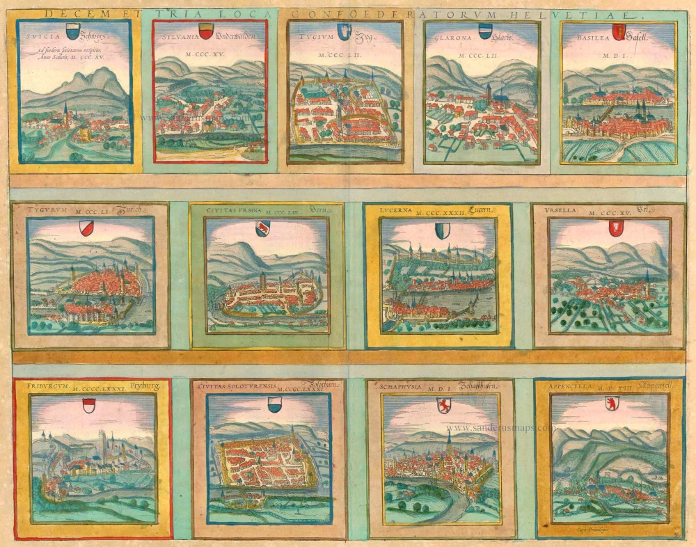
Decem et Tria Loca Confoederatorum Helvetiae. 1572-1624
13 bird's-eye views of Swiss cities by Braun and Hogenberg: Schwyz, Unterwalden, Zug, Glarus, Basel, Zurich, Bern, Lucerne, Uri, Fribourg, Solothurn, Schaffhausen and Appenzell.
[Item number: 23230]
Zurych - Tigurum, sive Turegum, Caesari, ut Plerique Existimant, Tigurinus Pagus, vulgo Zurych, Urbs in Helvetijs 1588
Zürich, by Braun & Hogenberg.
[Item number: 25148]

Zurych - Tigurum, sive Turegum, Caesari, ut Plerique Existimant, Tigurinus Pagus, vulgo Zurych, Urbs in Helvetijs 1582
Zürich by Georg Braun & Frans Hogenberg.
[Item number: 28827]