
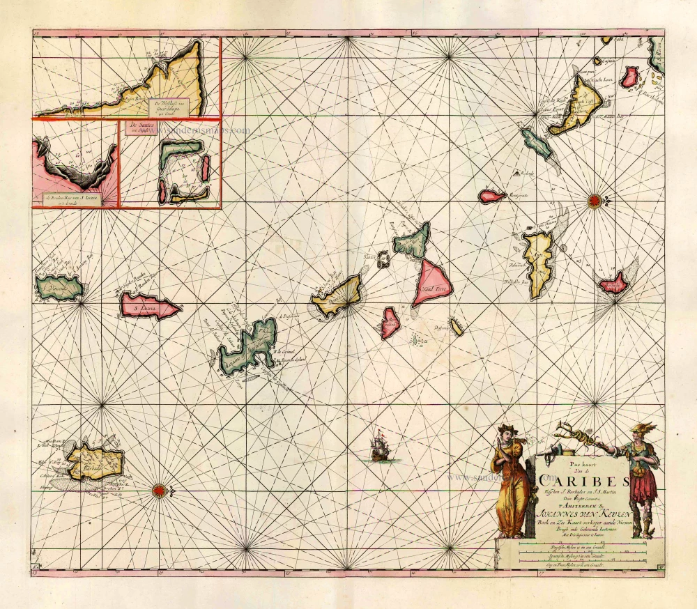
Heightened in gold
Sea chart of the Lesser Antilles, by Pieter Goos. 1667

Pieter Goos (1615-1675)
Pieter Goos, son of the engraver Abraham Goos, was one of the best known maritime booksellers of Amsterdam. He was not only a bookseller but also a copper-engraver and even a book printer.
His first pilot book, the Lichtende Columne ofte Zee-Spiegel appeared in 1650. The well-made pilot guides and the beautiful sea-atlas reflect a high professional standard. The many editions published over 28 years is an indication of the customers’ appreciation. The Zeespiegel was printed in Dutch, French (1662), and English (1658). Goos printed all the time from the same 60 plates. For his Straetsboeck, being the third part of the Zeespiegel, Pieter Goos copied the text from Lootsman’s Straetboeck and copied also the plates. This atlas of the Mediterranean appeared in 1662.
Pieter Goos also published a fourth and fifth part of his Zeespiegel. For the fourth part, he used the second part of Het Brandende Veen by Arent Roggeveen, which dealt with the coasts of West-Africa (No copy with Goos’s imprint is known). For the fifth part, he used the first part of Het Brandende Veen, which appeared in 1675. It contains the charts and sailing directions for the West Indies.
The first edition of his sea-atlas, the Zee-Atlas ofte Water-Wereld, came out in 1666. For the design of the charts, Goos copied nearly all the charts from Hendrik Doncker’s sea-atlas. All the years through, till 1675 (the year of his death), the number of 40 or 41 maps remained the same.
When Pieter Goos died in March 1675, his widow continued the shop. She brought out a few new editions of the Zee-Atlas with 44 charts. Part of the atlases was sold then by the famous Amsterdam bookbinder Albert Magnus. These copies are renowned for their outstanding colouring. She died in 1677; their son, Hendrik Goos, born in 1641, took over and sold his father’s pilot books until 1680.
Pascaert vande Caribes Eylanden.
Item Number: 25708 Authenticity Guarantee
Category: Antique maps > America > West Indies
Old, antique sea chart of the West Indies - Lesser Antilles by P. Goos, oriented to the West
Copper engraving
Size (not including margins): 44.5 x 54cm (17.3 x 21.1 inches)
Verso: Blank
Condition: Original coloured, heightened in gold, excellent.
Condition Rating: A+
References: Koeman, Goos1B (36).
From: De Zee-Atlas, Ofte Water-Weereld, Waer in vertoont werden alle de Zee-Kusten Van het bekende des Aerd-Bodems. P. Goos, 1666. (Koeman, Goos1B)
"Pieter Goos' marine atlases were held to be among the finest printed at the time and were often added tot the nine or twelve volumes of Blaeu's Atlas Maior." (Shirley)
Pieter Goos (1615-1675)
Pieter Goos, son of the engraver Abraham Goos, was one of the best known maritime booksellers of Amsterdam. He was not only a bookseller but also a copper-engraver and even a book printer.
His first pilot book, the Lichtende Columne ofte Zee-Spiegel appeared in 1650. The well-made pilot guides and the beautiful sea-atlas reflect a high professional standard. The many editions published over 28 years is an indication of the customers’ appreciation. The Zeespiegel was printed in Dutch, French (1662), and English (1658). Goos printed all the time from the same 60 plates. For his Straetsboeck, being the third part of the Zeespiegel, Pieter Goos copied the text from Lootsman’s Straetboeck and copied also the plates. This atlas of the Mediterranean appeared in 1662.
Pieter Goos also published a fourth and fifth part of his Zeespiegel. For the fourth part, he used the second part of Het Brandende Veen by Arent Roggeveen, which dealt with the coasts of West-Africa (No copy with Goos’s imprint is known). For the fifth part, he used the first part of Het Brandende Veen, which appeared in 1675. It contains the charts and sailing directions for the West Indies.
The first edition of his sea-atlas, the Zee-Atlas ofte Water-Wereld, came out in 1666. For the design of the charts, Goos copied nearly all the charts from Hendrik Doncker’s sea-atlas. All the years through, till 1675 (the year of his death), the number of 40 or 41 maps remained the same.
When Pieter Goos died in March 1675, his widow continued the shop. She brought out a few new editions of the Zee-Atlas with 44 charts. Part of the atlases was sold then by the famous Amsterdam bookbinder Albert Magnus. These copies are renowned for their outstanding colouring. She died in 1677; their son, Hendrik Goos, born in 1641, took over and sold his father’s pilot books until 1680.
Related items
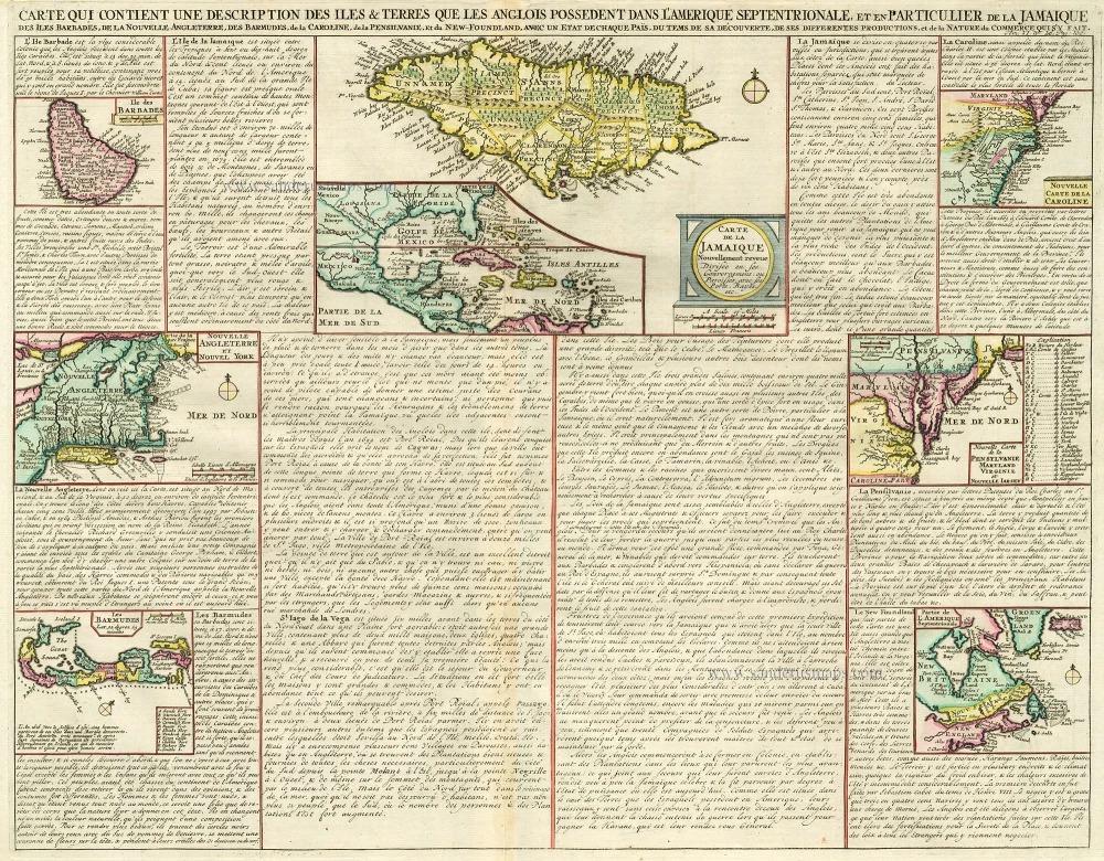
Carte qui Contient une Description des Iles & Terres que les Anglois Possèdent dans l'Amerique Septentrionale, et en Particulier de la Jamaique, .. 1713-1719
West Indies, Bermuda, New England, Virginia by Châtelain.
[Item number: 16834]
Pas Kaart van de Caribes tusschen I. Barbados en I.S. Martin. 1684
The Lesser Antilles, by J. Van Keulen.
[Item number: 2377]
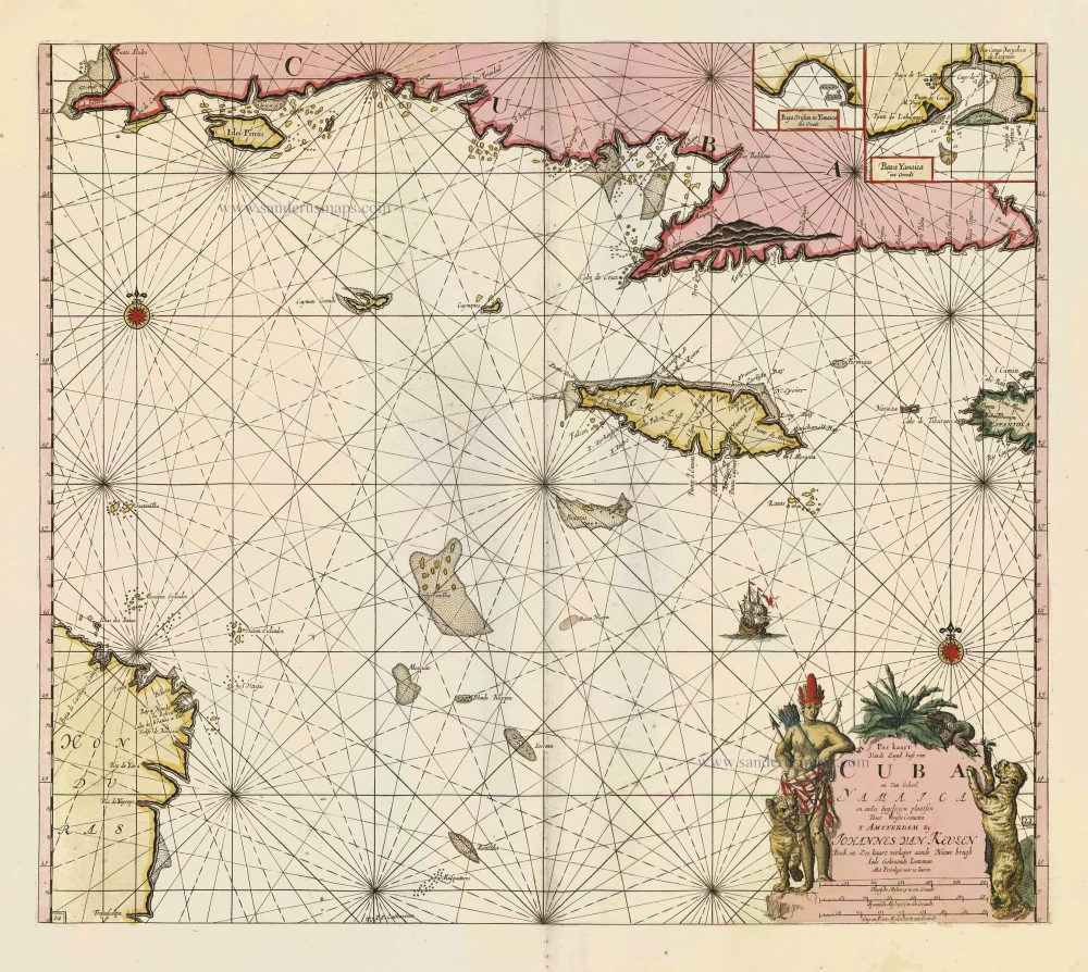
Pas Kaart vande Zuyd Kust van Cuba en van Geheel Yamaica en and're Bygeleegen Plaatsen ... 1697-1709
Cuba - Jamaica by Johannes van Keulen
[Item number: 11219]

Pas Kaart van de Boght van Florida met de Canaal tusschen Florida en Cuba ... 1680-1694
Sea chart of the Gulf of Mexico, Yucatan Channel, by J. Van Keulen.
[Item number: 16285]
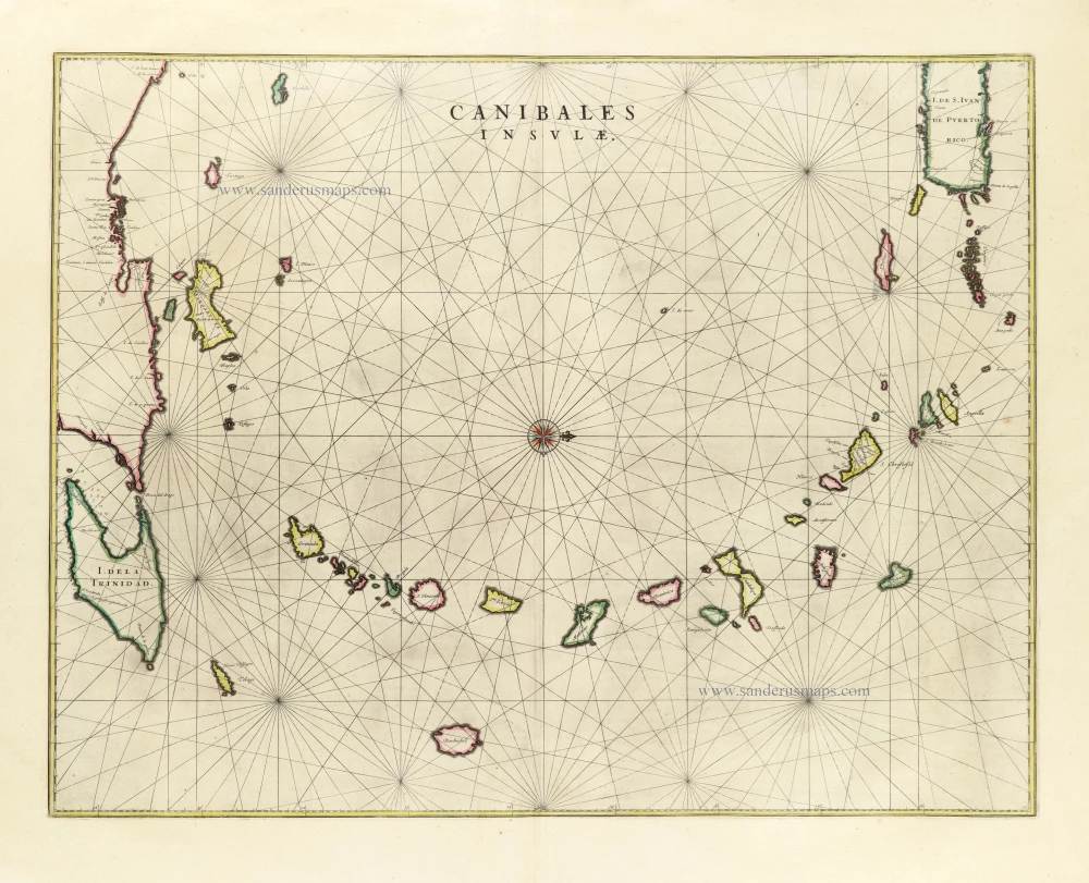
Canibales Insulae. 1662
Sea chart of the Lesser Antilles, by Joan Blaeu.
[Item number: 26737]
In excellent condition
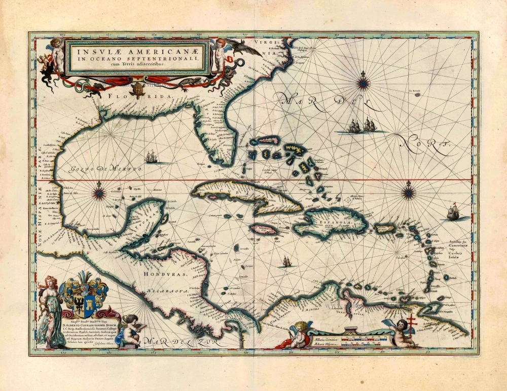
Insulae Americanae in Oceano Septentrionali, cum Terris Adiacentibus. 1643-50
West Indies by Willem Blaeu.
[Item number: 26985]
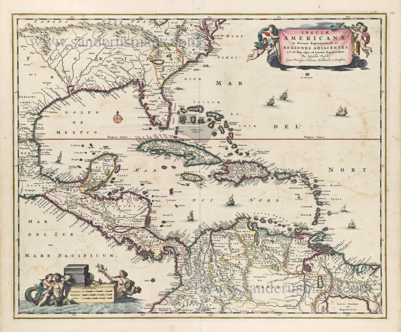
Insulae Americanae in Oceano Septentrionali ac Regiones Adiacentes, a. C. de May usque ad Lineam AEquinoctialem. c. 1682
The Antilles by Nicolaes Visscher II.
[Item number: 28553]
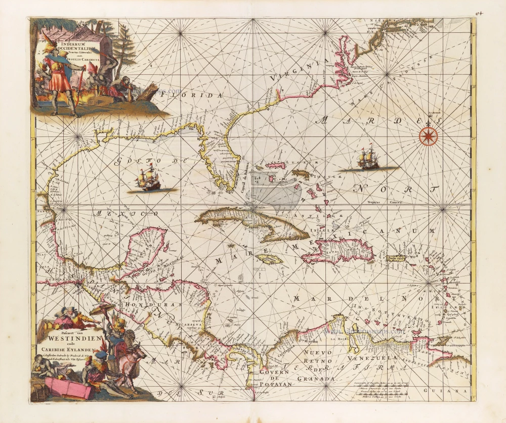
Indiarum Occidentalium Tractus Littoralis cum Insulis Caribicis. - Pascaert van Westindien ende Caribise Eylanden. c. 1680
West Indies, by Frederick de Wit.
[Item number: 29176]
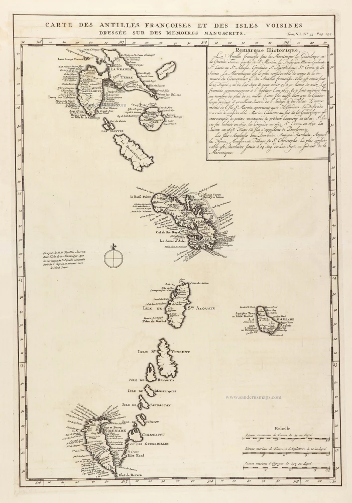
Carte des Antilles françoises et des Isles voisines dressée sur ledes memoires manuscrits. 1719
French Antilles and Lesser Antilles islands, by Z. Châtelain.
[Item number: 29359]