
The first sea chart relating to North America to use the Mercator projection
Atlantic Ocean. by P. Goos - J. Van Keulen c. 1680

The title appears in a cartouche in the interior of North Africa, and a second cartouche with the name Pieter Goos has been placed in the interior of North America. The map extends from Ireland to Newfoundland in the north, to the Cape of Good Hope and the Rio de la Plata in the south, and from the Gulf of Mexico in the west to Greece in the east. An inset map in the interior of South America shows that part of the continent that could not be included in the main map.
This very large map is printed on four sheets from just one printing plate. Rather than being printed from four separate plates and the four sheets then being joined, this map was printed from a single large plate, once for the upper part on two joined sheets and the same for the lower part, then the two parts being joined.
Pieter Goos was nearing the end of his career when he published a derivative of Willem Blaeu's great West Indische Paskaert of c.1630 (Burden, #233). The Blaeu was of landmark importance, being the first sea chart depicting North America to use Mercator's projection.
Van Keulen published loose large portolan-style charts such as this one derived directly from Willem Blaeu's West-Indische Paskaert. He left Goos' imprint as he was a noted chart maker and van Keulen's reputation was yet to be made, but he also added his own imprint: Seyn nu te Bekoomen By Iohannus van Kuelen. (Burden)
There are two states of this chart:
State 1 c.1774 With the sole imprint of Pieter Goos, upper left
State 2 c.1680 With the additional imprint of J. Van Keulen. New lines are inserted off the west coast of Africa, lettered A-G.
Blaeu's chart was called "A scientific and artistic document of the first order, marking an important date in the history of nautical cartography and one of the most important contributions that the Lowlands produced in the XVII century." (Destombes & Gernez).
Pieter Goos (1615-1675)
Pieter Goos, son of the engraver Abraham Goos, was one of the best known maritime booksellers of Amsterdam. He was not only a bookseller but also a copper-engraver and even a book printer.
His first pilot book, the Lichtende Columne ofte Zee-Spiegel appeared in 1650. The well-made pilot guides and the beautiful sea-atlas reflect a high professional standard. The many editions published over 28 years is an indication of the customers’ appreciation. The Zeespiegel was printed in Dutch, French (1662), and English (1658). Goos printed all the time from the same 60 plates. For his Straetsboeck, being the third part of the Zeespiegel, Pieter Goos copied the text from Lootsman’s Straetboeck and copied also the plates. This atlas of the Mediterranean appeared in 1662.
Pieter Goos also published a fourth and fifth part of his Zeespiegel. For the fourth part, he used the second part of Het Brandende Veen by Arent Roggeveen, which dealt with the coasts of West-Africa (No copy with Goos’s imprint is known). For the fifth part, he used the first part of Het Brandende Veen, which appeared in 1675. It contains the charts and sailing directions for the West Indies.
The first edition of his sea-atlas, the Zee-Atlas ofte Water-Wereld, came out in 1666. For the design of the charts, Goos copied nearly all the charts from Hendrik Doncker’s sea-atlas. All the years through, till 1675 (the year of his death), the number of 40 or 41 maps remained the same.
When Pieter Goos died in March 1675, his widow continued the shop. She brought out a few new editions of the Zee-Atlas with 44 charts. Part of the atlases was sold then by the famous Amsterdam bookbinder Albert Magnus. These copies are renowned for their outstanding colouring. She died in 1677; their son, Hendrik Goos, born in 1641, took over and sold his father’s pilot books until 1680.
The House of Van Keulen
For more than two centuries, the chart makers firm of Van Keulen was established in the house with the name of “De Gekroonde Lootsman” (The Crowned Pilot). In 1678, the founder of the firm, Johannes I Van Keulen (1634-1689), registered with the Amsterdam booksellers’ guild. He had enlisted the aid of the well-known Mathematical Practitioner Claas Janz Vooght in the preparation of his nautical publications. In 1680 he published the first edition of the Zee-Atlas with 40 charts, all issued for the first time. In the short period of four years, they produced the five volumes of the Nieuwe Groote Ligtende Zee-Fakkel (1681-85). His acquisition of the stock of the bookseller Hendrik Doncker was an essential factor in the development of the firm.
In 1678 a son, Gerard Van Keulen (1678-1726), was born out of Johannes’s first marriage. This son was endowed with talent. He was a skilful engraver and proficient in mathematics and navigational science. Gerard was responsible for establishing the scientific basis of the firm of Van Keulen. In 1714 he was appointed to the office of hydrographer to the Dutch East India Company. The Van Keulens remained chart makers to the East India Company until the Company’s liquidation.
With the introductions to the Zee-Fakkel and Zee-Atlas, Gerard van Keulen gave a new impetus to the firm. Unfortunately, he did not live long, dying when he was 49. The business was carried on by his widow Ludwina Konst. Shortly before Gerard’s death, his son Johannes II had entered the bookseller’s guild, and in 1726 he assumed the management of the firm, though his mother retained her financial interests in the business.
Johannes II Van Keulen (1704-1755) is known in particular for his publication in 1753 of a sixth volume of the Zee-Fakkel, the volume containing the charts of the route to the East Indies.
Johannes II had two sons; they joined the firm as partners in 1757. A considerable number of books appeared in the period 1778-1801. New issues of the Zee-Fakkel again saw the light. The firm flourished under different names until 1885.
West-Indische Paskaert waer in de graden der breedde over wederzijden vande middellijn wassende so vergrooten dat die geproportioneert sijn tegen hunne nevenstaende graden der lengde; ...
Item Number: 25938 Authenticity Guarantee
Category: Antique maps > America > The Americas
Extremely rare and important wall map of the Atlantic Ocean, first published by W. Blaeu in 1630 and then republished by P. Goos c.1674 and J. Van Keulen c.1680.
Title: West-Indische Paskaert waer in de graden der breedde over wederzijden vande middellijn wassende so vergrooten dat die geproportioneert sijn tegen hunne nevenstaende graden der lengde; ...
Date: c. 1680.
Copper engraving, printed on paper.
Size (not including margins): 810 x 990mm (31.89 x 38.98 inches).
Verso: Blank.
Condition: Original coloured, mint.
Condition Rating: A+.
Separate publication.
The title appears in a cartouche in the interior of North Africa, and a second cartouche with the name Pieter Goos has been placed in the interior of North America. The map extends from Ireland to Newfoundland in the north, to the Cape of Good Hope and the Rio de la Plata in the south, and from the Gulf of Mexico in the west to Greece in the east. An inset map in the interior of South America shows that part of the continent that could not be included in the main map.
This very large map is printed on four sheets from just one printing plate. Rather than being printed from four separate plates and the four sheets then being joined, this map was printed from a single large plate, once for the upper part on two joined sheets and the same for the lower part, then the two parts being joined.
Pieter Goos was nearing the end of his career when he published a derivative of Willem Blaeu's great West Indische Paskaert of c.1630 (Burden, #233). The Blaeu was of landmark importance, being the first sea chart depicting North America to use Mercator's projection.
Van Keulen published loose large portolan-style charts such as this one derived directly from Willem Blaeu's West-Indische Paskaert. He left Goos' imprint as he was a noted chart maker and van Keulen's reputation was yet to be made, but he also added his own imprint: Seyn nu te Bekoomen By Iohannus van Kuelen. (Burden)
There are two states of this chart:
State 1 c.1774 With the sole imprint of Pieter Goos, upper left
State 2 c.1680 With the additional imprint of J. Van Keulen. New lines are inserted off the west coast of Africa, lettered A-G.
Blaeu's chart was called "A scientific and artistic document of the first order, marking an important date in the history of nautical cartography and one of the most important contributions that the Lowlands produced in the XVII century." (Destombes & Gernez).
Pieter Goos (1615-1675)
Pieter Goos, son of the engraver Abraham Goos, was one of the best known maritime booksellers of Amsterdam. He was not only a bookseller but also a copper-engraver and even a book printer.
His first pilot book, the Lichtende Columne ofte Zee-Spiegel appeared in 1650. The well-made pilot guides and the beautiful sea-atlas reflect a high professional standard. The many editions published over 28 years is an indication of the customers’ appreciation. The Zeespiegel was printed in Dutch, French (1662), and English (1658). Goos printed all the time from the same 60 plates. For his Straetsboeck, being the third part of the Zeespiegel, Pieter Goos copied the text from Lootsman’s Straetboeck and copied also the plates. This atlas of the Mediterranean appeared in 1662.
Pieter Goos also published a fourth and fifth part of his Zeespiegel. For the fourth part, he used the second part of Het Brandende Veen by Arent Roggeveen, which dealt with the coasts of West-Africa (No copy with Goos’s imprint is known). For the fifth part, he used the first part of Het Brandende Veen, which appeared in 1675. It contains the charts and sailing directions for the West Indies.
The first edition of his sea-atlas, the Zee-Atlas ofte Water-Wereld, came out in 1666. For the design of the charts, Goos copied nearly all the charts from Hendrik Doncker’s sea-atlas. All the years through, till 1675 (the year of his death), the number of 40 or 41 maps remained the same.
When Pieter Goos died in March 1675, his widow continued the shop. She brought out a few new editions of the Zee-Atlas with 44 charts. Part of the atlases was sold then by the famous Amsterdam bookbinder Albert Magnus. These copies are renowned for their outstanding colouring. She died in 1677; their son, Hendrik Goos, born in 1641, took over and sold his father’s pilot books until 1680.
The House of Van Keulen
For more than two centuries, the chart makers firm of Van Keulen was established in the house with the name of “De Gekroonde Lootsman” (The Crowned Pilot). In 1678, the founder of the firm, Johannes I Van Keulen (1634-1689), registered with the Amsterdam booksellers’ guild. He had enlisted the aid of the well-known Mathematical Practitioner Claas Janz Vooght in the preparation of his nautical publications. In 1680 he published the first edition of the Zee-Atlas with 40 charts, all issued for the first time. In the short period of four years, they produced the five volumes of the Nieuwe Groote Ligtende Zee-Fakkel (1681-85). His acquisition of the stock of the bookseller Hendrik Doncker was an essential factor in the development of the firm.
In 1678 a son, Gerard Van Keulen (1678-1726), was born out of Johannes’s first marriage. This son was endowed with talent. He was a skilful engraver and proficient in mathematics and navigational science. Gerard was responsible for establishing the scientific basis of the firm of Van Keulen. In 1714 he was appointed to the office of hydrographer to the Dutch East India Company. The Van Keulens remained chart makers to the East India Company until the Company’s liquidation.
With the introductions to the Zee-Fakkel and Zee-Atlas, Gerard van Keulen gave a new impetus to the firm. Unfortunately, he did not live long, dying when he was 49. The business was carried on by his widow Ludwina Konst. Shortly before Gerard’s death, his son Johannes II had entered the bookseller’s guild, and in 1726 he assumed the management of the firm, though his mother retained her financial interests in the business.
Johannes II Van Keulen (1704-1755) is known in particular for his publication in 1753 of a sixth volume of the Zee-Fakkel, the volume containing the charts of the route to the East Indies.
Johannes II had two sons; they joined the firm as partners in 1757. A considerable number of books appeared in the period 1778-1801. New issues of the Zee-Fakkel again saw the light. The firm flourished under different names until 1885.
Related items
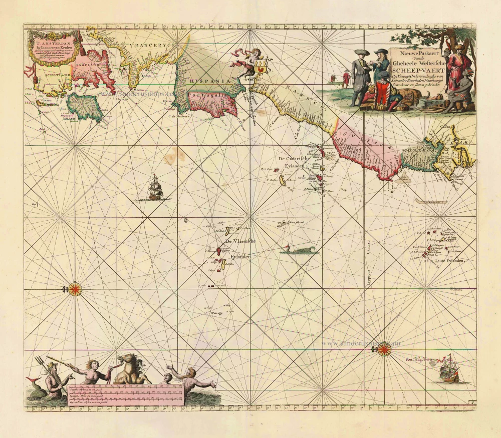
Nieuwe Paskaert vande Gheheele Westersche Scheep-Vaert, op Nieus uyt Ondervindinghe van Schrandre Stierlieden Naaukeurigh Geteeckent en Samen Gebracht. 1697-1709
The Atlantic Ocean, by J. Van Keulen.
[Item number: 11218]

Ocean Atlantique et Mers Adjacentes en Quatre Feuilles Contenant les Cotes de l'Europe, de l'Afrique et de l'Amerique ... 1778
The Atlantic Ocean, by G.L. Le Rouge.
[Item number: 14086]
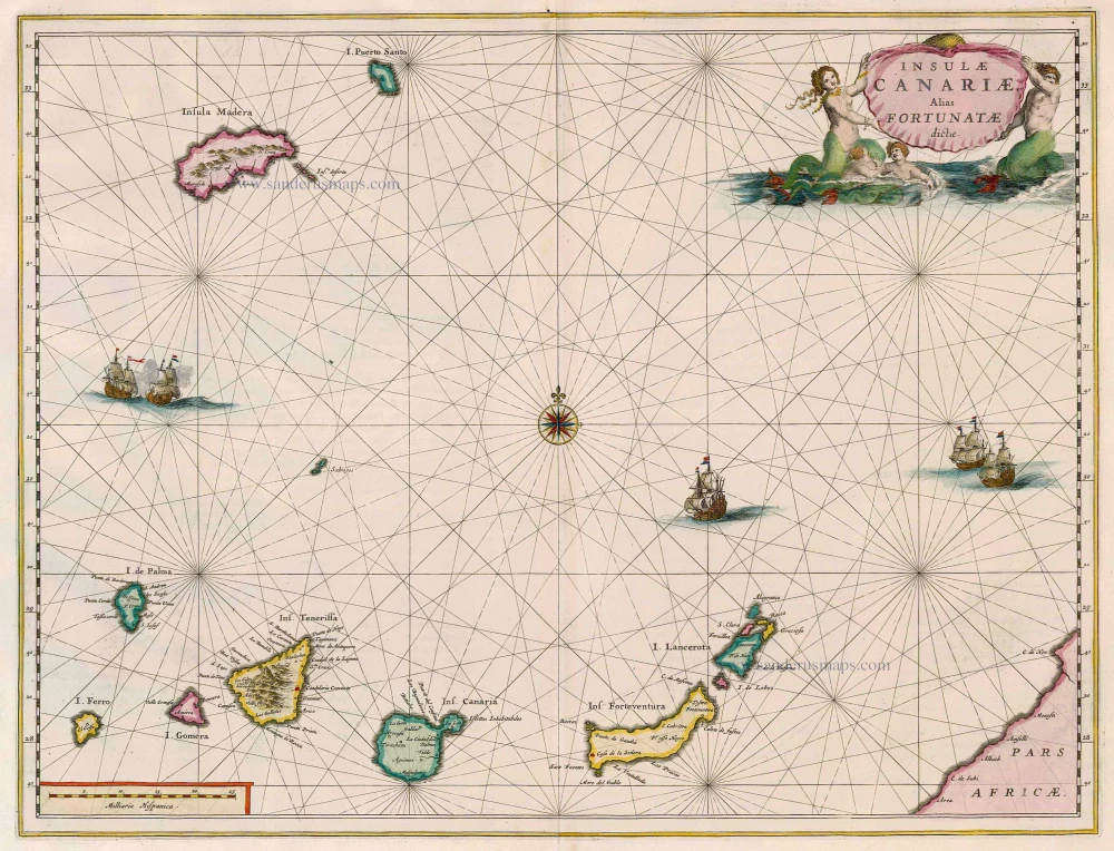
Insulae Canariae alias Fortunatae Dictae 1664-65
Canary Islands, by Joan Blaeu.
[Item number: 14157]
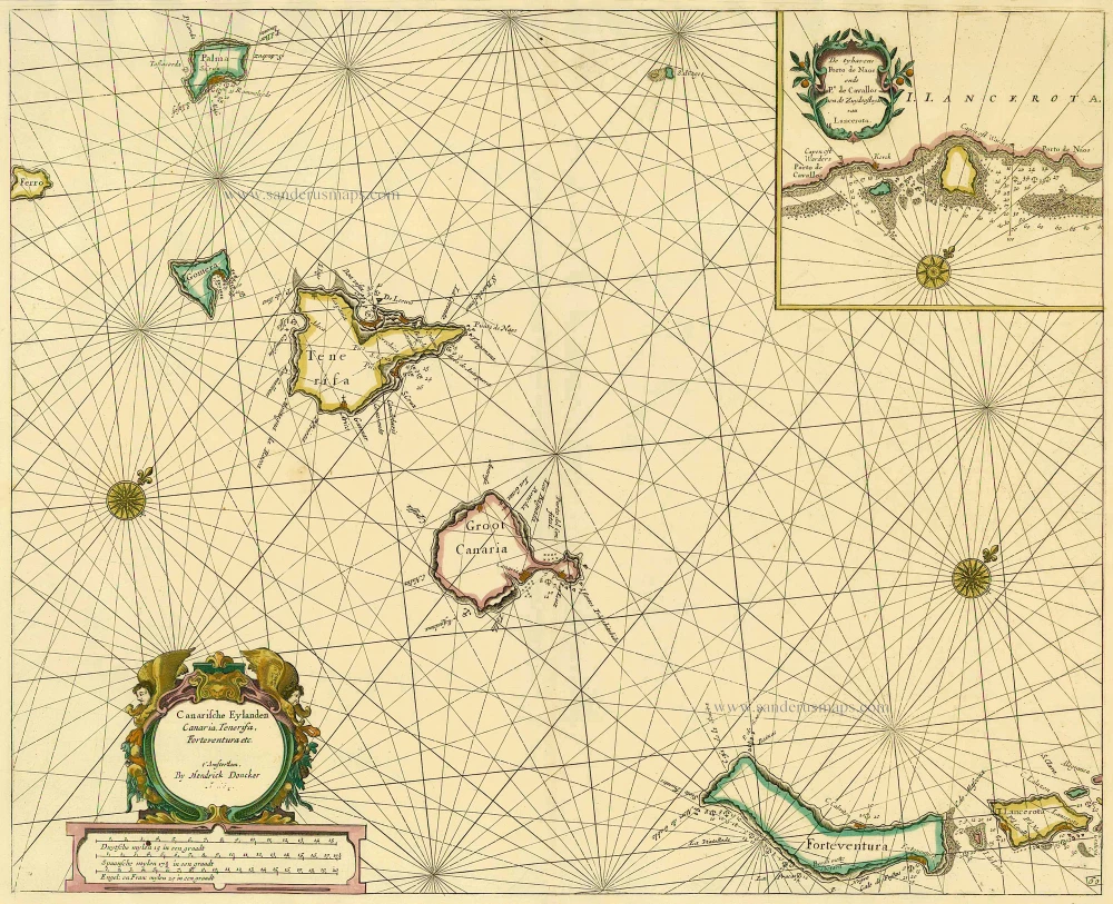
Canarische Eylanden Canaria Tenerifa, Forteventura etc. t' Amsterdam, 1686
Canary Islands, by Hendrick Doncker.
[Item number: 15419]

Paskaart van de Cust van Portugal, Barbaria, en Genehoa Beginnende van d'Barlengers tot aan C. Verde. 1680-1694
Sea chart of the northwest coast of Africa, with the Azores, Canary Islands and Cape Verde Islands, by Johannes Van Keulen.
[Item number: 26808]
Rare.
[No title] c. 1575
Atlantic Ocean - Europe, Africa & Eastern Canada by Giovanni Francesco Camocio
[Item number: 27086]
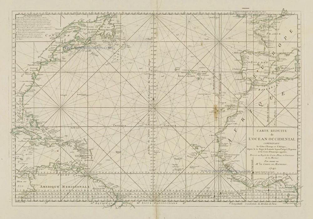
Carte Reduite de l'Ocean Occidental comprenant les Côtes d'Europe et d'Afrique, depuis le 52 Degré de Latitude Sept. jusqu'à l'Equateur et les Cotes d'Amerique opposées. 1756-1770
Atlantic Ocean, by J.N. Bellin.
[Item number: 28087]
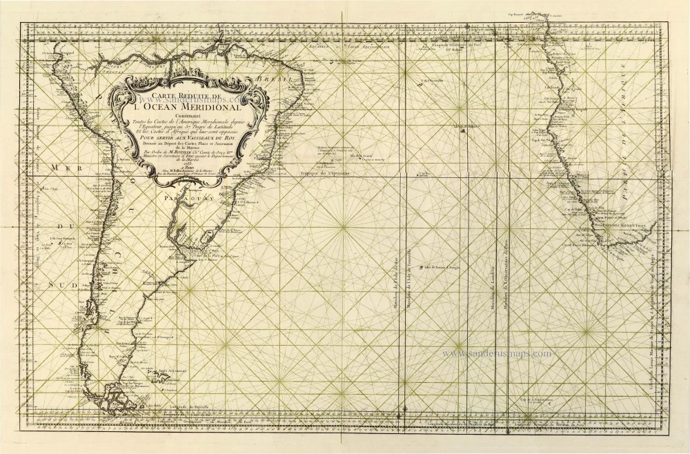
Carte Reduite de l'Ocean Meridionale Contenant Toutes les Costes de l'Amerique Meridionale depuis l'Equateur jusqu'au 57 Degré de Latitude et les Costes d'Afrique qui leurs sont opposées; 1756-1770
Southern Atlantic Ocean, by J.N. Bellin.
[Item number: 28089]
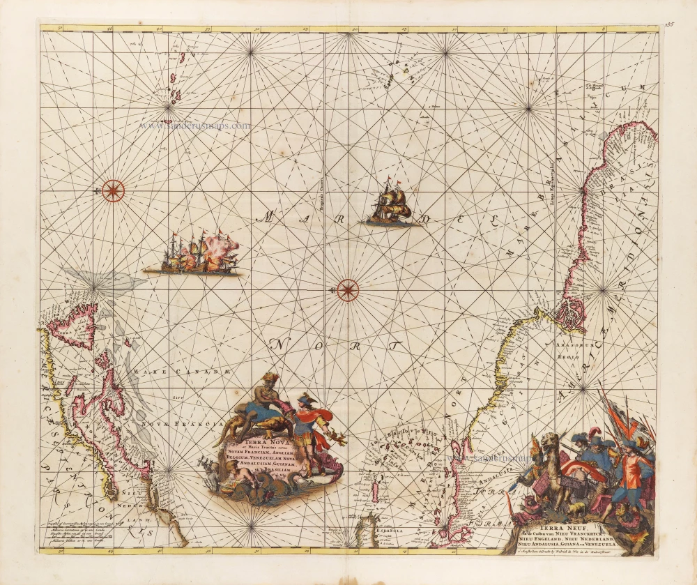
Terra Nova ac Maris Tractus circa Novam Franciam, Angliam, Belgium, Venezuelam Novam, Andalusiam, Guianam, et Brasiliam. - Terra Neuf, en de Custen van Nieu Vranckryck, Nieu Engeland, Nieu Nederland, Nieu Andalusia, Guiana en Venezuela. c. 1680
The Western Atlantic Ocean, by Frederick de Wit.
[Item number: 29175]