
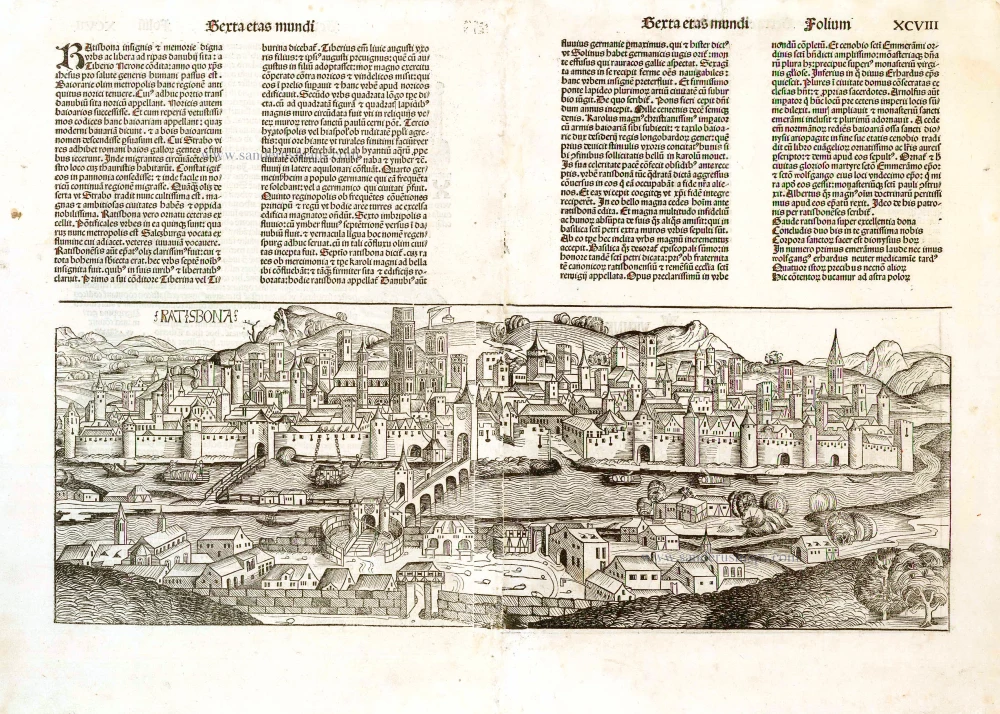
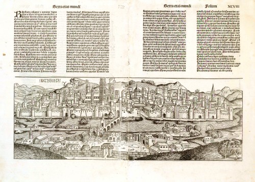
Regensburg, by H. Schedel. 1493
Hartmann Schedel (Nuremberg, 1440-1514) and the Nuremberg Chronicle.
Hartmann Schedel grew up in Nuremberg and first studied liberal art in Leipzig. He earned a doctorate in medicine in Padua in 1466, then settled in Nuremberg to practice medicine and collect books. According to an inventory done in 1498, Schedel's library contained 370 manuscripts and 670 printed books.
Schedel is best known for his writing the text for the Nuremberg Chronicle, an illustrated biblical paraphrase and world history that follows the story of human history related in the Bible; it includes the histories of many important Western cities. The Nuremberg Chronicle was one of the most remarkable books of its time. It was commissioned by Sebald Schreyer (1446–1520) and Sebastian Kammermeister (1446–1503) and published in 1493 in Nuremberg. Maps in the Chronicle were the first-ever illustrations of many cities and countries. Wolgemut and Pleydenwurff, the painters, were commissioned to provide the illustrations and to take care of the layout. The large workshop of Michael Wolgemut, then Nuremberg's leading artist in various media, provided the 1,809 woodcut illustrations (duplications included).
Albrecht Dürer was an apprentice with Wolgemut from 1486 to 1489, so he may well have participated in designing some of the illustrations.
The Liber Chronicarum was first published in Latin on 12 July 1493 in the city of Nuremberg, printed by Anton Koberger, the most successful publisher in Germany. A German translation followed on 23 December 1493. An estimated 1400 to 1500 Latin and 700 to 1000 German copies were published.
Due to the great success and prestige of the Chronicle, pirate editions soon appeared on the market. Johann Schönsperger (c. 1455-1521), a printer working out of Augsburg, published smaller editions of the Chronicle in 1496, 1497, and 1500 in German, and Latin.
Ratisbona.
Item Number: 26582 Authenticity Guarantee
Category: Antique maps > Europe > Germany - Cities
Old, antique map - View of Regensburg, by H. Schedel.
Date of the first edition: 1493
Date of this map: 1493
Woodcut, printed on a double sheet (joined).
Size: 19.5 x 52.5cm (7.6 x 20.5 inches)
Verso text: Latin
Condition: Centrefold restored.
Condition Rating: B
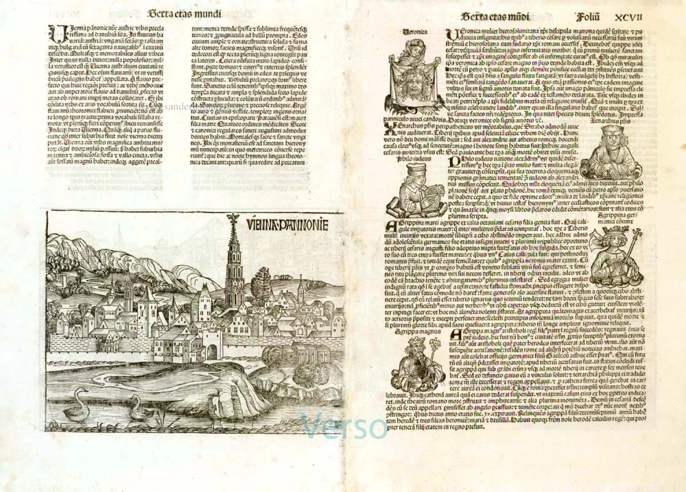
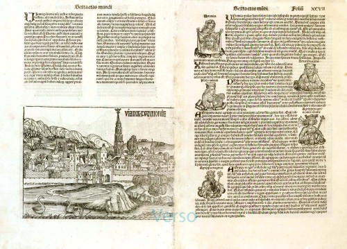
On verso: left half of the view of Wien (Vienna Pannonie).
Folio XCVII (97) and XCVIII (98) from: Liber Chronicarum. (= Nuremberg Chronicle). Nuremberg, Koberger, 1493.
This major work, by the Nuremberg doctor Hartmann Schedel, generally known as the Nuremberg Chronicle was printed by Anton Koberger, the foremost printer of the day. It is a history of the world from the Creation to contemporary times. The work is remarkable for its illustrations, design and its woodcuts and description of cities. The views are some of the earliest representations of towns and cities, with around 116 places being identified by name. The numerous woodcut views, illustrations and maps are made by Michael Wohlgemuth and Wilhem Pleydenwurff and their workshop including Albrecht Dürer.
Hartmann Schedel (Nuremberg, 1440-1514) and the Nuremberg Chronicle.
Hartmann Schedel grew up in Nuremberg and first studied liberal art in Leipzig. He earned a doctorate in medicine in Padua in 1466, then settled in Nuremberg to practice medicine and collect books. According to an inventory done in 1498, Schedel's library contained 370 manuscripts and 670 printed books.
Schedel is best known for his writing the text for the Nuremberg Chronicle, an illustrated biblical paraphrase and world history that follows the story of human history related in the Bible; it includes the histories of many important Western cities. The Nuremberg Chronicle was one of the most remarkable books of its time. It was commissioned by Sebald Schreyer (1446–1520) and Sebastian Kammermeister (1446–1503) and published in 1493 in Nuremberg. Maps in the Chronicle were the first-ever illustrations of many cities and countries. Wolgemut and Pleydenwurff, the painters, were commissioned to provide the illustrations and to take care of the layout. The large workshop of Michael Wolgemut, then Nuremberg's leading artist in various media, provided the 1,809 woodcut illustrations (duplications included).
Albrecht Dürer was an apprentice with Wolgemut from 1486 to 1489, so he may well have participated in designing some of the illustrations.
The Liber Chronicarum was first published in Latin on 12 July 1493 in the city of Nuremberg, printed by Anton Koberger, the most successful publisher in Germany. A German translation followed on 23 December 1493. An estimated 1400 to 1500 Latin and 700 to 1000 German copies were published.
Due to the great success and prestige of the Chronicle, pirate editions soon appeared on the market. Johann Schönsperger (c. 1455-1521), a printer working out of Augsburg, published smaller editions of the Chronicle in 1496, 1497, and 1500 in German, and Latin.
Related items
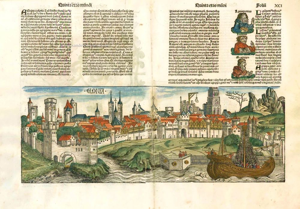
Colonia. 1493
Cologne (Köln), by Hartmann Schedel.
[Item number: 10231]
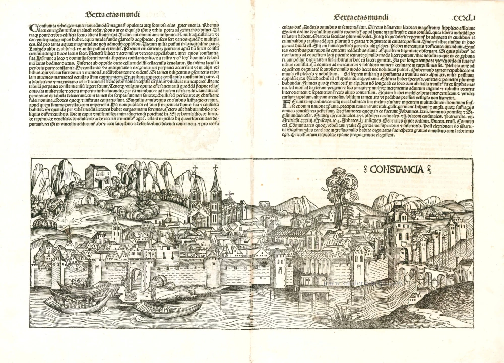
Constancia 1493
Konstanz by Hartmann Schedel.
[Item number: 24392]
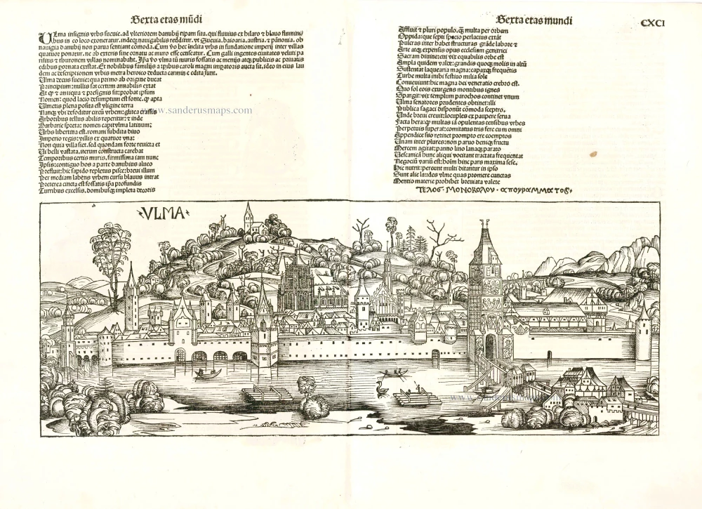
Ulma 1493
Ulm by Hartmann Schedel.
[Item number: 24393]

ULMA 1493
Ulm, by Hartmann Schedel.
[Item number: 10102]

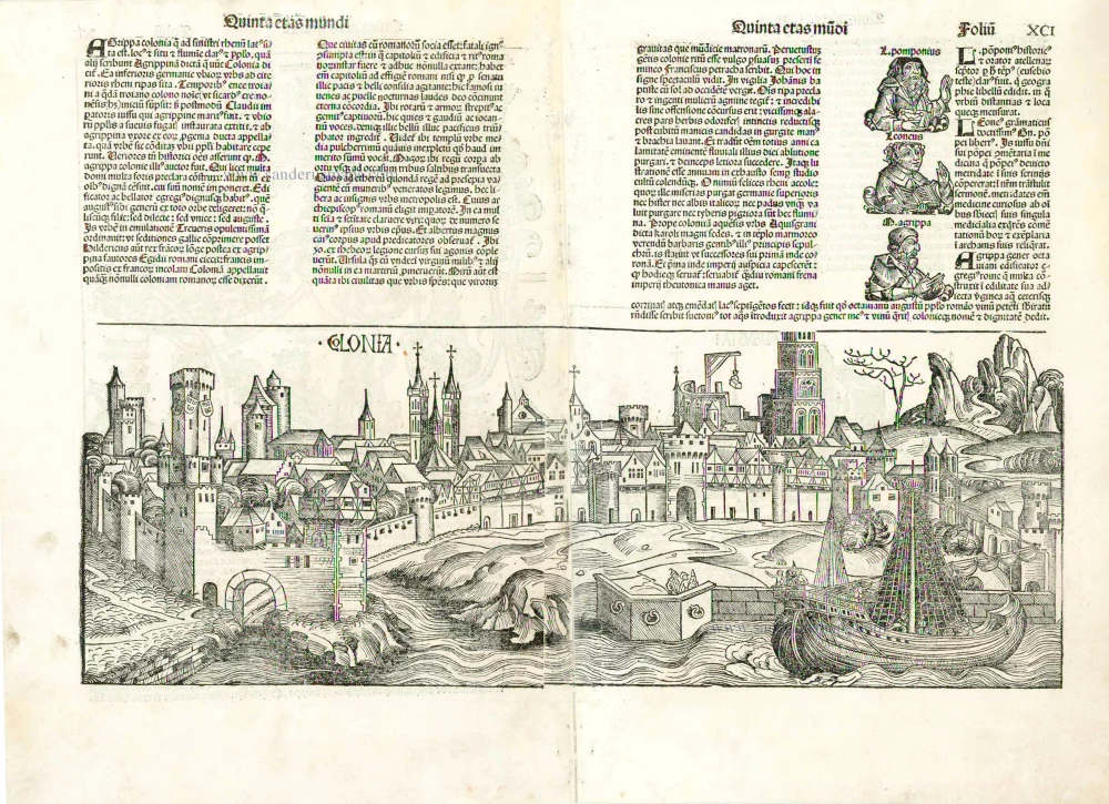
Colonia 1493
Old, antique map - Double page panoramic view of Cologne (Köln) by H. Schedel
[Item number: 5306]
Colonia [on verso:] Augusta 1493
Cologne and Augsburg (recto-verso), by Hartmann Schedel.
[Item number: 2964]
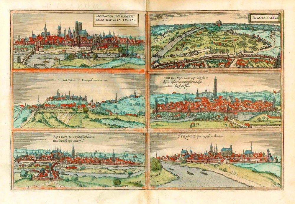
Monacum, nominatis sima Bavariae, Civitas [on sheet with] Ingolstadium [and] Frisingensis ... [and] Nordlinga ... [and] Ratispona ... [and] Straubinga ...
1577
München, Ingolstadt, Freissing, Nördlingen, Regensburg and Straubing, by Georg Braun and Frans Hogenberg.
[Item number: 26679]
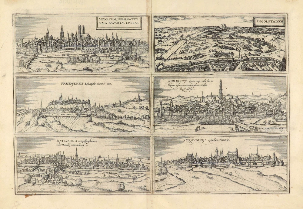
Monacum, nominatis sima Bavariae, Civitas. [on sheet with] Ingolstadium. [and] Frisingensis Episcopalis civitatis icon. [and] Nordlinga Civitas imperialis sita in Rhetia inferioris transdanubiana, vulgo Rieß dicta. [and] Ratispona antiquissima Bavariae urbs, Danubij ripis adiacet. [and] Straubinga oppidum Bavariae. 1574
München, Ingolstadt, Freising, Nördlingen, Regensburg and Straubing, by Georg Braun & Frans Hogenberg.
[Item number: 28041]
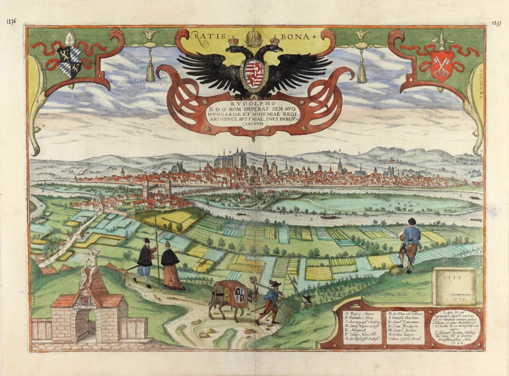
Ratisbona. c. 1610
Regensburg by Georg Braun & Frans Hogenberg.
[Item number: 29953]