
Amsterdam, by Georg Braun & Frans Hogenberg. 1582
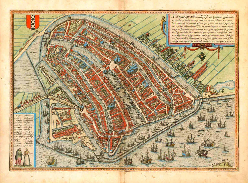


TRANSLATION OF CARTOUCHE TEXT: Amsterdam is a well-known city in Lower Germany that has recently arisen to accommodate merchants and is inhabited by people engaged in trade. It is almost impossible to think of a commercial activity not practised here. Hence profit-seeking business people are drawn to this city from faraway lands and transship various goods, first and foremost grain, to Brabant and other parts of the world. Vast riches result from the trade of this kind.
COMMENTARY BY BRAUN: "Holland is the most fertile part of the Netherlands. It is crossed by many waterways full of fish, which ensure that in the whole world, there is no other landscape in which so many cities lie within such a confined area ... Amongst these, Amsterdam is the noblest ... It lies on the River Amstel, from which many canals lead into the city. About twice a year, many ships arrive here from all over Europe, some 200 or 300 from the Netherlands, France, England, Spain, Portugal, Germany, Poland, Lithuania, Norway, Sweden and the other countries of the North. ... There are also very good and experienced ship-builders here. ... This city is supported on large and sturdy wooden stilts that have been driven into the bed of the water. When you see the air, the sea, the dams and the many sluices, you can easily compare the city with Venice and consider it just as fortunate."
The plan presents Amsterdam in a bird's-eye view from a northeasterly direction. On the left-hand side, we can see how the mouth of the River Amstel has been dammed, and its waters channelled into canals and made to pass through the city before flowing out into the Zuiderzee (today the IJsselmeer). The canals, used to transport imported goods to the counting houses located all over the city, are lined with private houses, commercial buildings and warehouses. In the centre of the plan, the old town hall (Stadhuis, 21) and the neighbouring Nieuwe Kerk (23) are also clearly recognizable. With its depiction of the heavy shipping traffic inside the harbour and on the Zuiderzee, the engraving conveys an impression of the contemporary scale of trade conducted in the continually expanding metropolis. In the 13th century, Amsterdam was a small fishing port built on marshy ground. In 1300 it was granted its municipal charter and, in 1369, became a member of the Hansa. Not until the beginning of the 1600s did the city finally establish itself as the leading trade centre and the constantly expanding hub of a global financial and commercial empire. This Golden Age brought an economic boom and a flowering of the sciences and arts, which lasted until the end of the 17th century: Between 1570 and 1640, Amsterdam's population grew from around 30,000 to almost 140,000; today, it numbers about 750,000. (Taschen)
Braun G. & Hogenberg F. and the Civitates Orbis Terrarum.
The Civitates Orbis Terrarum, or the "Braun & Hogenberg", is a six-volume town atlas and the most excellent book of town views and plans ever published: 363 engravings, sometimes beautifully coloured. It was one of the best-selling works in the last quarter of the 16th century. Georg Braun wrote the text accompanying the plans and views on the verso. Many plates were engraved after the original drawings of a professional artist, a professional artist, Joris Hoefnagel (1542-1600). The first volume was published in Latin in 1572, and the sixth in 1617. Frans Hogenberg created the tables for volumes I through IV, and Simon van den Neuwel made those for volumes V and VI. Other contributors were cartographers Daniel Freese and Heinrich Rantzau. Works by Jacob van Deventer, Sebastian Münster, and Johannes Stumpf were also used. Translations appeared in German and French.
Following the original publication of Volume 1 of the Civitates in 1572, seven further editions of 1575, 1577, 1582, 1588, 1593, 1599 and 1612 can be identified. Vol.2, first issued in 1575, was followed by further editions in 1597 and 1612. The subsequent volumes appeared in 1581, 1588, 1593, 1599 and 1606. The German translation of the first volume appeared from 1574 on, and the French edition from 1575 on.
Several printers were involved: Theodor Graminaeus, Heinrich von Aich, Gottfried von Kempen, Johannis Sinniger, Bertram Buchholtz and Peter von Brachel, who all worked in Cologne.
Georg Braun (1541-1622)
Georg Braun was born in Cologne in 1541. After his studies in Cologne, he entered the Jesuit Order as a novice. 1561, he obtained his bachelor's degree, and in 1562, he received his Magister Artium. Although he left the Jesuit Order, he studied theology, gaining a licentiate in theology.
Frans Hogenberg (1535-1590)
Frans Hogenberg was a Flemish and German painter, engraver, and mapmaker. He was born in Mechelen as the son of Nicolaas Hogenberg.
By the end of the 1560s, Frans Hogenberg was employed upon Abraham Ortelius's Theatrum Orbis Terrarum, published in 1570; he is named an engraver of numerous maps. In 1568, he was banned from Antwerp by the Duke of Alva and travelled to London, where he stayed a few years before emigrating to Cologne. He immediately embarked on his two most important works, the Civitates, published in 1572 and the Geschichtsblätter, which appeared in several series from 1569 until about 1587.
Thanks to large-scale projects like the Geschichtsblätter and the Civitates, Hogenberg's social circumstances improved with each passing year. He died as a wealthy man in Cologne in 1590.
Amstelredamum, Nobile Inferioris Germaniae Oppidum ...
Item Number: 26732 Authenticity Guarantee
Category: Antique maps > Europe > The Netherlands - Cities
Old, antique map - bird's-eye view plan of Amsterdam, by Georg Braun & Frans Hogenberg.
With key to locations.
Date of the first edition: 1572
Date of this map: 1582
Copper engraving
Size (not including margins): 34 x 49cm (13.3 x 19.1 inches)
Verso text: Latin
Condition: Original coloured, lower centrefold split reinforced, some browning along centrefold.
Condition Rating: B
From: Beschreibung und Contrafactur der vornembster Stät der Welt. [Part 1] Cologne, Gottfried von Kempen, 1582. (Van der Krogt 4, 41:2.1)
TRANSLATION OF CARTOUCHE TEXT: Amsterdam is a well-known city in Lower Germany that has recently arisen to accommodate merchants and is inhabited by people engaged in trade. It is almost impossible to think of a commercial activity not practised here. Hence profit-seeking business people are drawn to this city from faraway lands and transship various goods, first and foremost grain, to Brabant and other parts of the world. Vast riches result from the trade of this kind.
COMMENTARY BY BRAUN: "Holland is the most fertile part of the Netherlands. It is crossed by many waterways full of fish, which ensure that in the whole world, there is no other landscape in which so many cities lie within such a confined area ... Amongst these, Amsterdam is the noblest ... It lies on the River Amstel, from which many canals lead into the city. About twice a year, many ships arrive here from all over Europe, some 200 or 300 from the Netherlands, France, England, Spain, Portugal, Germany, Poland, Lithuania, Norway, Sweden and the other countries of the North. ... There are also very good and experienced ship-builders here. ... This city is supported on large and sturdy wooden stilts that have been driven into the bed of the water. When you see the air, the sea, the dams and the many sluices, you can easily compare the city with Venice and consider it just as fortunate."
The plan presents Amsterdam in a bird's-eye view from a northeasterly direction. On the left-hand side, we can see how the mouth of the River Amstel has been dammed, and its waters channelled into canals and made to pass through the city before flowing out into the Zuiderzee (today the IJsselmeer). The canals, used to transport imported goods to the counting houses located all over the city, are lined with private houses, commercial buildings and warehouses. In the centre of the plan, the old town hall (Stadhuis, 21) and the neighbouring Nieuwe Kerk (23) are also clearly recognizable. With its depiction of the heavy shipping traffic inside the harbour and on the Zuiderzee, the engraving conveys an impression of the contemporary scale of trade conducted in the continually expanding metropolis. In the 13th century, Amsterdam was a small fishing port built on marshy ground. In 1300 it was granted its municipal charter and, in 1369, became a member of the Hansa. Not until the beginning of the 1600s did the city finally establish itself as the leading trade centre and the constantly expanding hub of a global financial and commercial empire. This Golden Age brought an economic boom and a flowering of the sciences and arts, which lasted until the end of the 17th century: Between 1570 and 1640, Amsterdam's population grew from around 30,000 to almost 140,000; today, it numbers about 750,000. (Taschen)
Braun G. & Hogenberg F. and the Civitates Orbis Terrarum.
The Civitates Orbis Terrarum, or the "Braun & Hogenberg", is a six-volume town atlas and the most excellent book of town views and plans ever published: 363 engravings, sometimes beautifully coloured. It was one of the best-selling works in the last quarter of the 16th century. Georg Braun wrote the text accompanying the plans and views on the verso. Many plates were engraved after the original drawings of a professional artist, a professional artist, Joris Hoefnagel (1542-1600). The first volume was published in Latin in 1572, and the sixth in 1617. Frans Hogenberg created the tables for volumes I through IV, and Simon van den Neuwel made those for volumes V and VI. Other contributors were cartographers Daniel Freese and Heinrich Rantzau. Works by Jacob van Deventer, Sebastian Münster, and Johannes Stumpf were also used. Translations appeared in German and French.
Following the original publication of Volume 1 of the Civitates in 1572, seven further editions of 1575, 1577, 1582, 1588, 1593, 1599 and 1612 can be identified. Vol.2, first issued in 1575, was followed by further editions in 1597 and 1612. The subsequent volumes appeared in 1581, 1588, 1593, 1599 and 1606. The German translation of the first volume appeared from 1574 on, and the French edition from 1575 on.
Several printers were involved: Theodor Graminaeus, Heinrich von Aich, Gottfried von Kempen, Johannis Sinniger, Bertram Buchholtz and Peter von Brachel, who all worked in Cologne.
Georg Braun (1541-1622)
Georg Braun was born in Cologne in 1541. After his studies in Cologne, he entered the Jesuit Order as a novice. 1561, he obtained his bachelor's degree, and in 1562, he received his Magister Artium. Although he left the Jesuit Order, he studied theology, gaining a licentiate in theology.
Frans Hogenberg (1535-1590)
Frans Hogenberg was a Flemish and German painter, engraver, and mapmaker. He was born in Mechelen as the son of Nicolaas Hogenberg.
By the end of the 1560s, Frans Hogenberg was employed upon Abraham Ortelius's Theatrum Orbis Terrarum, published in 1570; he is named an engraver of numerous maps. In 1568, he was banned from Antwerp by the Duke of Alva and travelled to London, where he stayed a few years before emigrating to Cologne. He immediately embarked on his two most important works, the Civitates, published in 1572 and the Geschichtsblätter, which appeared in several series from 1569 until about 1587.
Thanks to large-scale projects like the Geschichtsblätter and the Civitates, Hogenberg's social circumstances improved with each passing year. He died as a wealthy man in Cologne in 1590.
Related items
Amsterdam. 1659
Amsterdam by Merian M.
[Item number: 25404]
Amsterdam. 1638
Amsterdam, by M. Merian.
[Item number: 25887]
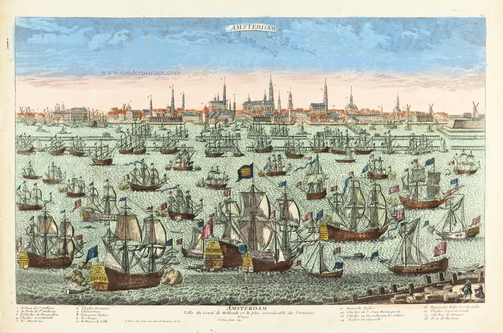
Amsterdam Ville du Comté de Hollande et la plus considerable des Provinces Unies. c. 1780
Amsterdam by Pierre Aveline, published in Paris by Jean.
[Item number: 28778]