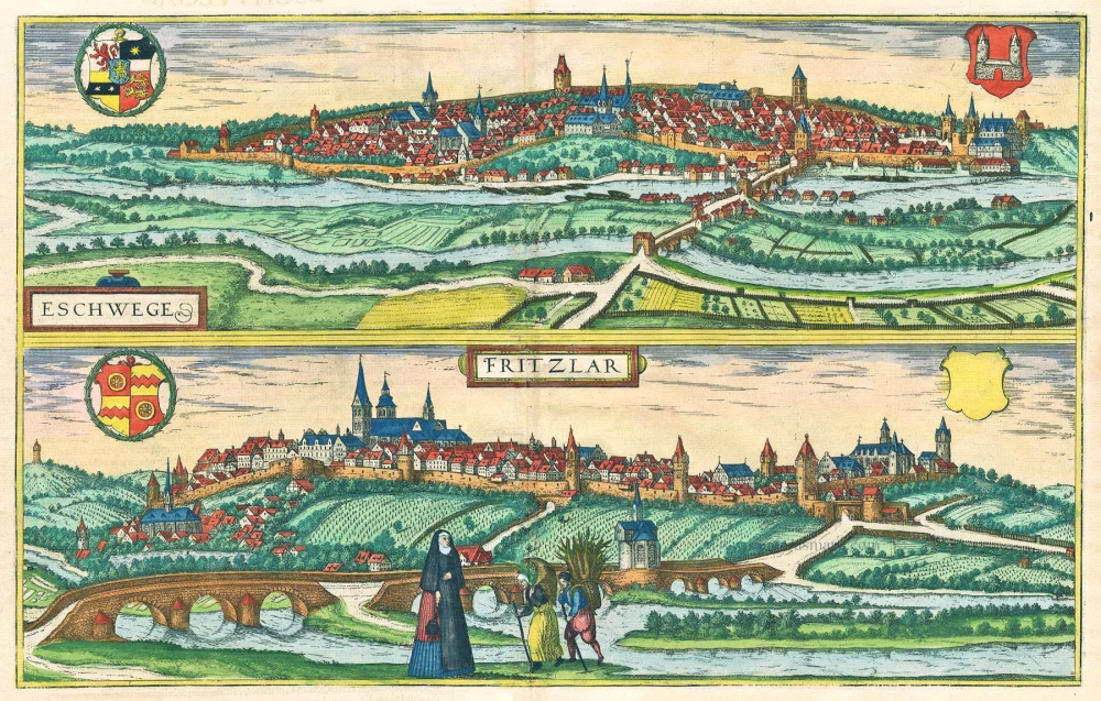
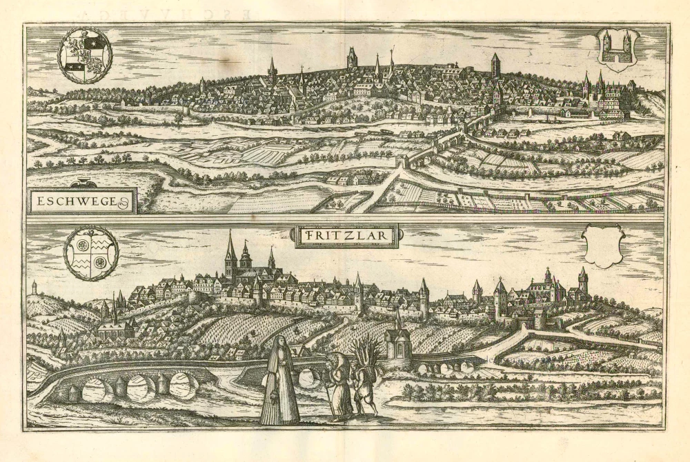
Eschwege and Fritzlar, by Georg Braun and Frans Hogenberg. 1581


Braun G. & Hogenberg F. and the Civitates Orbis Terrarum.
The Civitates Orbis Terrarum, or the "Braun & Hogenberg", is a six-volume town atlas and the most excellent book of town views and plans ever published: 363 engravings, sometimes beautifully coloured. It was one of the best-selling works in the last quarter of the 16th century. Georg Braun wrote the text accompanying the plans and views on the verso. Many plates were engraved after the original drawings of a professional artist, a professional artist, Joris Hoefnagel (1542-1600). The first volume was published in Latin in 1572, and the sixth in 1617. Frans Hogenberg created the tables for volumes I through IV, and Simon van den Neuwel made those for volumes V and VI. Other contributors were cartographers Daniel Freese and Heinrich Rantzau. Works by Jacob van Deventer, Sebastian Münster, and Johannes Stumpf were also used. Translations appeared in German and French.
Following the original publication of Volume 1 of the Civitates in 1572, seven further editions of 1575, 1577, 1582, 1588, 1593, 1599 and 1612 can be identified. Vol.2, first issued in 1575, was followed by further editions in 1597 and 1612. The subsequent volumes appeared in 1581, 1588, 1593, 1599 and 1606. The German translation of the first volume appeared from 1574 on, and the French edition from 1575 on.
Several printers were involved: Theodor Graminaeus, Heinrich von Aich, Gottfried von Kempen, Johannis Sinniger, Bertram Buchholtz and Peter von Brachel, who all worked in Cologne.
Georg Braun (1541-1622)
Georg Braun was born in Cologne in 1541. After his studies in Cologne, he entered the Jesuit Order as a novice. 1561, he obtained his bachelor's degree, and in 1562, he received his Magister Artium. Although he left the Jesuit Order, he studied theology, gaining a licentiate in theology.
Frans Hogenberg (1535-1590)
Frans Hogenberg was a Flemish and German painter, engraver, and mapmaker. He was born in Mechelen as the son of Nicolaas Hogenberg.
By the end of the 1560s, Frans Hogenberg was employed upon Abraham Ortelius's Theatrum Orbis Terrarum, published in 1570; he is named an engraver of numerous maps. In 1568, he was banned from Antwerp by the Duke of Alva and travelled to London, where he stayed a few years before emigrating to Cologne. He immediately embarked on his two most important works, the Civitates, published in 1572 and the Geschichtsblätter, which appeared in several series from 1569 until about 1587.
Thanks to large-scale projects like the Geschichtsblätter and the Civitates, Hogenberg's social circumstances improved with each passing year. He died as a wealthy man in Cologne in 1590.
Eschwege [on sheet with] Fritzlar.
Item Number: 26931 Authenticity Guarantee
Category: Antique maps > Europe > Germany - Cities
Old, antique map with two bird's-eye views by Georg Braun and Frans Hogenberg: Eschwege and Fritzlar.
Zwei antike Gesamtansichten von Georg Braun und Frans Hogenberg: Dresden und Leipzig.
ESCHWEGE
COMMENTARY BY BRAUN: "Eschwege is a town in Hesse, which lies on a hill, surrounded by fertile farmland and with the Werra flowing by. Here the woad plant, along with the blue dye that is made from it and which is found a plenty all over Thuringia, is loaded onto boats a mile higher up and transported along the Werra to Minden and then down the Weser, into which the Werra flows, towards Bremen."
Eschwege is seen in bird's-eye perspective looking accross the Werra. A stone bridge leads via the island in the river to the town rising on the opposite shore. The skyline is puntuated by the landgrave's castle (far right) and several church towers, inlcuding the market church of St Dionys and the late Gothic, three-aisled church of St Catherine. Eschwege was granted its charter in 1326 and from 1433 belonged to the Landgraviate of Hesse. The local cultivation of the dye-yielding woad plant meant that Eschwege developed into a trade town for cloth and woad.
FRITZLAR
COMMENTARY BY BRAUN: "Fritzlar possesses a ring wall with many towers and lies in a countryside of rolling hills. It nevertheless has very fertile farmland, on which cereals, fruit and legumes grow. Vines also flourish there, although the countryside is not known for its wine on the whole. And although Fritzlar lies in Hesse, it belongs to the archbishop of Mainz. It has consequently had to endure numerous military onslaughts and also the most base treatment from the Dukes of Hesse, as well as from the Saxons, who conquered the city and set fire to it."
Fritzlar is seen from the south in a view overlooking the Eder, which is crossed in the foreground by the stone bridge that helped fuel the town's development. Inside the ramparts on the left is the Romanesque and Gothic collegiate church of St Peter, erected on the site of the Benedictine monastery founded by St Boniface in AD 724; on the far right lies the Franciscan monastery, founded in the 13th/14th centuries, with its Minorite church. The former imperial residence was probably built under Charlemagne; over the following centuries it gained in political and economic importance and hosted a number of synods, diets and souvereign assemblies. In the 11th century Fritzlar passed into the possession of the archbishops of Mainz, which led to a multitude of conflicts with the princes of Hesse. (Taschen)
Date of the first edition: 1581
Date of this map: 1581
Copper engraving, printed on paper.
Size (not including margins): 30.5 x 48.5cm (11.9 x 18.9 inches)
Verso text: Latin
Condition: Original coloured, excellent.
Condition Rating: A
References: Van der Krogt 4, #1255; Fauser, #3745, #4306; Taschen, Br. Hog., p.238.
From: Civitates Orbis Terrarum. . Liber tertius. Cologne, Gottfried von Kempen, 1581. (Van der Krogt 4, 41:1.3)
Braun G. & Hogenberg F. and the Civitates Orbis Terrarum.
The Civitates Orbis Terrarum, or the "Braun & Hogenberg", is a six-volume town atlas and the most excellent book of town views and plans ever published: 363 engravings, sometimes beautifully coloured. It was one of the best-selling works in the last quarter of the 16th century. Georg Braun wrote the text accompanying the plans and views on the verso. Many plates were engraved after the original drawings of a professional artist, a professional artist, Joris Hoefnagel (1542-1600). The first volume was published in Latin in 1572, and the sixth in 1617. Frans Hogenberg created the tables for volumes I through IV, and Simon van den Neuwel made those for volumes V and VI. Other contributors were cartographers Daniel Freese and Heinrich Rantzau. Works by Jacob van Deventer, Sebastian Münster, and Johannes Stumpf were also used. Translations appeared in German and French.
Following the original publication of Volume 1 of the Civitates in 1572, seven further editions of 1575, 1577, 1582, 1588, 1593, 1599 and 1612 can be identified. Vol.2, first issued in 1575, was followed by further editions in 1597 and 1612. The subsequent volumes appeared in 1581, 1588, 1593, 1599 and 1606. The German translation of the first volume appeared from 1574 on, and the French edition from 1575 on.
Several printers were involved: Theodor Graminaeus, Heinrich von Aich, Gottfried von Kempen, Johannis Sinniger, Bertram Buchholtz and Peter von Brachel, who all worked in Cologne.
Georg Braun (1541-1622)
Georg Braun was born in Cologne in 1541. After his studies in Cologne, he entered the Jesuit Order as a novice. 1561, he obtained his bachelor's degree, and in 1562, he received his Magister Artium. Although he left the Jesuit Order, he studied theology, gaining a licentiate in theology.
Frans Hogenberg (1535-1590)
Frans Hogenberg was a Flemish and German painter, engraver, and mapmaker. He was born in Mechelen as the son of Nicolaas Hogenberg.
By the end of the 1560s, Frans Hogenberg was employed upon Abraham Ortelius's Theatrum Orbis Terrarum, published in 1570; he is named an engraver of numerous maps. In 1568, he was banned from Antwerp by the Duke of Alva and travelled to London, where he stayed a few years before emigrating to Cologne. He immediately embarked on his two most important works, the Civitates, published in 1572 and the Geschichtsblätter, which appeared in several series from 1569 until about 1587.
Thanks to large-scale projects like the Geschichtsblätter and the Civitates, Hogenberg's social circumstances improved with each passing year. He died as a wealthy man in Cologne in 1590.