
Very rare first state
Guyana by Theodor de Bry. 1599
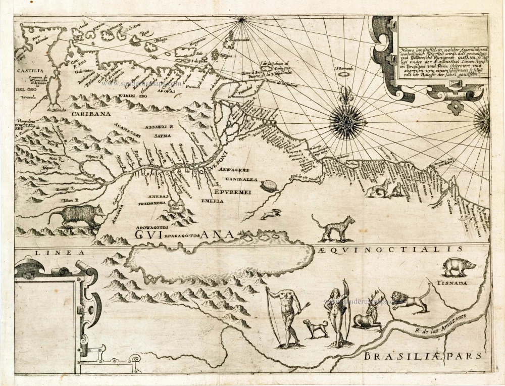
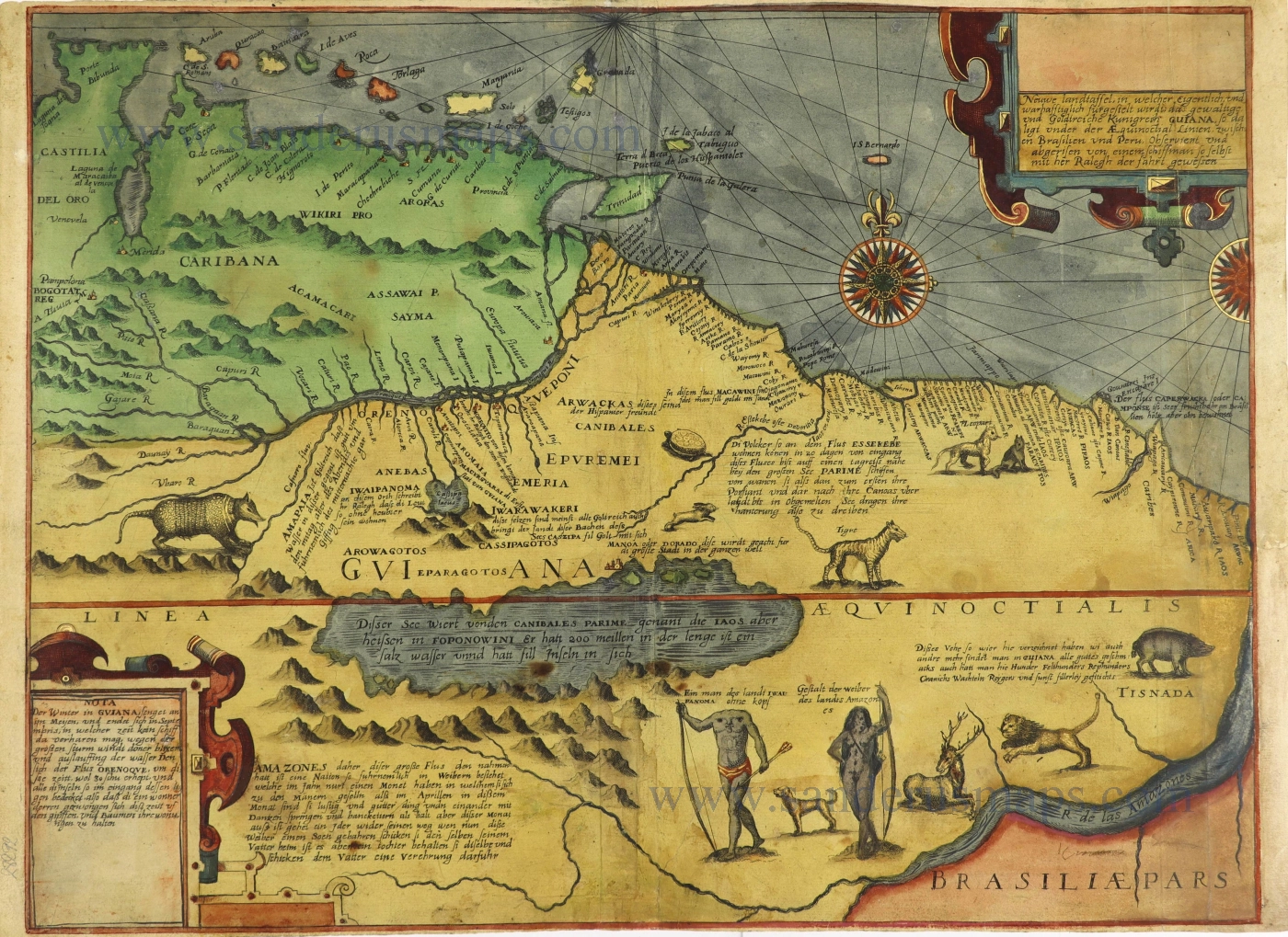
Lake Parime is a fictitious lake in Guiana, in northern South America, often shown prominently on the Equator. It appears in printed maps from about 1596 into the 1770s.
"The map of 'the powerful and gold-bearing kingdom of Guiana' is adapted from a slightly earlier map by Jodocus Hondius, although the title states that the map was 'surveyed and drawn by a sailor who accompanies Walter Raleigh on his voyage' (of 1595). Note the large body of water placed south of the River Orinoco called by the cannibals Parime. On the northern shore lies the city of 'Manoa or Dorado, the greatest city in the world.' Such features recall a map drawn by Raleigh in c. 1595 showing the region of El Dorado. The geography of the interior regions is derived from the accounts of Raleigh himself and of Laurent Keymis, who in 1596 reported 'a sea of saltwater, named Parime,' lying 'farre within' on the route to Manoa. Placed at the foot of the map are figures of an Amazon and a 'headless man of the land Ewaipanoma.' On the final state is a note that states that the Amazons live with men only during April." (Garratt)
Theodore de Bry (1528 – 1598) and his family.
Theodore de Bry was born in 1528 in the Prince-Bishopric of Liège, in the southern Netherlands (today Belgium). Trained as a goldsmith in his father's workshop, he left his home town around 1558 and moved to Strasbourg. Religious motives partly inspired his emigration, but commercial incentives were probably more important for de Bry since Strasbourg was more attractive. Here he gradually began to shift his focus to copper engraving. In the early 1560s, Theodore married Strasbourg-born Katharina Esslinger, and the couple went on to have four children together before Katharina died c. 1569. Johan Theodore (b. 1563) and Johan Israel (b. 1565) later followed in their father's footsteps and took up his trade. He remarried in 1570 to Katharina Rölinger.
In 1577, after the Pacification of Gent had quietened religious tensions in the Netherlands, Theodore and his family moved to Antwerp. There they lived close to the printing house of Christopher Plantin, and it was there that Theodore began making copper engravings. Copper engraving was a well-developed art in the Low Countries, and Antwerp artists were in great demand. In 1584, when Catholic troops besieged Antwerp, Theodore and his family moved to London, where he made copper engravings for an important English navigation manual, The Mariners Mirrour. It was also there that he found the inspiration to produce the collection to which his name would forever be attached.
He met the artist Jacques Le Moyne de Morgues, a draughtsman who had been to Florida in the 1560s as part of a French expedition. He returned to Europe with watercolours of the natural world he had seen and the indigenous peoples. After Le Moyne's death, thanks to the mediation of Richard Hakluyt, Theodore acquired these drawings.
Hakluyt and de Bry began collaborating on a series of books about America. In 1588, the de Bry family moved to Frankfurt, and there Theodore published the first volume of the America series. This first volume was the only one in the whole collection which appeared in four different languages: German, Latin, French and English. The following volumes appeared only in German and Latin. As a result, the relationship between de Bry and his English partners quickly soured.
Theodore continued publishing and produced a blend of richly illustrated prestigious volumes of the voyages collection, which was the family firm's flagship publication.
Theodore de Bry died on March 27th 1598. At this time, the highly successful and lucrative America series extended already to seven volumes, and there were going to be a total of fourteen. To these must be added the 'Elenchus', published in 1634 by Merian, which was a collective title and table of contents of these same volumes.
In 1597, the de Bry brothers published the first volume of the East India series. These were also published in folio but in a slightly smaller page size than the America volumes. In order to distinguish the East India series from his America series, the two parallel sets subsequently became known among bibliophiles as de Bry’s Petits Voyages and his Grands Voyages, respectively.
The Petits Voyages consist of thirteen volumes, published between 1597 and 1633.
After Theodore de Bry's death, the business was first run by his son, Johann Theodore and then by his grandson, Matthäus Merian and grandson-in-law, William Fitzer. Precisely what part de Bry's widow and his other son played in the business is unclear, but they certainly seemed to have retained some interest. After all, it must have become a very profitable venture for the whole family. Together, they continued to publish volumes of the Grands and Petits Voyages for another 46 years. The last volume, a third edition of Part IV of the America series, finally appeared in 1644.
Neuwe Landtaffel, in welcher eigentlich, und warhafftiglich furgestelt wird, das gewaltige und goldtreiche Kunigreich Guiana : so daligt under der aequinoctial Linien zwischer Brasilien und Peru / observiert und abgerisen von ein emschiffman so selbst mit her Ralegh der fahrt gewessen.
Item Number: 27037 Authenticity Guarantee
Category: Antique maps > America > South America
Old, antique map of the Oronoco Basin & Raleigh's "El Dorado". by Theodore de Bry.
A proof state of the map of Guiana derived from Raleigh. The two cartouches have blank spaces for inserting the Latin title (top right) and notes on Guiana and the Orinocco (bottom left). Notes relating to the Amazons and other tribes, the note on Parime and the labelling of Manoa or El dorado have also to be inserted.
Date of the first edition: 1599
Date of this map: 1599
Copper engraving, printed on paper.
Size (not including margins): 34 x 45cm (13.3 x 17.6 inches)
Verso: Blank
Condition: New left margin, excellent.
References: Garratt J., The Maps in De Bry, Map Collector, 1979, p.4-5.; Lake Parime, Map Forum, 2004.
From: [Voyages of Sir Francis Drake, Thomas Candish and Sir Walter Raleigh.] Americae pars VIII. Continens primo, descriptionem trium itinerum nobilissimi et fortissimi equitis Francisci Draken, qui peragrato primum universo terrarum orbe, postea cum nobilissimo equite Iohanne Hauckens, ad expug-nandum civitatem Panama, in Indiam navigavit, ubi vitam suam ambo finierunt. . . . Frankfurt am Main, 1599.
Lake Parime is a fictitious lake in Guiana, in northern South America, often shown prominently on the Equator. It appears in printed maps from about 1596 into the 1770s.
"The map of 'the powerful and gold-bearing kingdom of Guiana' is adapted from a slightly earlier map by Jodocus Hondius, although the title states that the map was 'surveyed and drawn by a sailor who accompanies Walter Raleigh on his voyage' (of 1595). Note the large body of water placed south of the River Orinoco called by the cannibals Parime. On the northern shore lies the city of 'Manoa or Dorado, the greatest city in the world.' Such features recall a map drawn by Raleigh in c. 1595 showing the region of El Dorado. The geography of the interior regions is derived from the accounts of Raleigh himself and of Laurent Keymis, who in 1596 reported 'a sea of saltwater, named Parime,' lying 'farre within' on the route to Manoa. Placed at the foot of the map are figures of an Amazon and a 'headless man of the land Ewaipanoma.' On the final state is a note that states that the Amazons live with men only during April." (Garratt)
Theodore de Bry (1528 – 1598) and his family.
Theodore de Bry was born in 1528 in the Prince-Bishopric of Liège, in the southern Netherlands (today Belgium). Trained as a goldsmith in his father's workshop, he left his home town around 1558 and moved to Strasbourg. Religious motives partly inspired his emigration, but commercial incentives were probably more important for de Bry since Strasbourg was more attractive. Here he gradually began to shift his focus to copper engraving. In the early 1560s, Theodore married Strasbourg-born Katharina Esslinger, and the couple went on to have four children together before Katharina died c. 1569. Johan Theodore (b. 1563) and Johan Israel (b. 1565) later followed in their father's footsteps and took up his trade. He remarried in 1570 to Katharina Rölinger.
In 1577, after the Pacification of Gent had quietened religious tensions in the Netherlands, Theodore and his family moved to Antwerp. There they lived close to the printing house of Christopher Plantin, and it was there that Theodore began making copper engravings. Copper engraving was a well-developed art in the Low Countries, and Antwerp artists were in great demand. In 1584, when Catholic troops besieged Antwerp, Theodore and his family moved to London, where he made copper engravings for an important English navigation manual, The Mariners Mirrour. It was also there that he found the inspiration to produce the collection to which his name would forever be attached.
He met the artist Jacques Le Moyne de Morgues, a draughtsman who had been to Florida in the 1560s as part of a French expedition. He returned to Europe with watercolours of the natural world he had seen and the indigenous peoples. After Le Moyne's death, thanks to the mediation of Richard Hakluyt, Theodore acquired these drawings.
Hakluyt and de Bry began collaborating on a series of books about America. In 1588, the de Bry family moved to Frankfurt, and there Theodore published the first volume of the America series. This first volume was the only one in the whole collection which appeared in four different languages: German, Latin, French and English. The following volumes appeared only in German and Latin. As a result, the relationship between de Bry and his English partners quickly soured.
Theodore continued publishing and produced a blend of richly illustrated prestigious volumes of the voyages collection, which was the family firm's flagship publication.
Theodore de Bry died on March 27th 1598. At this time, the highly successful and lucrative America series extended already to seven volumes, and there were going to be a total of fourteen. To these must be added the 'Elenchus', published in 1634 by Merian, which was a collective title and table of contents of these same volumes.
In 1597, the de Bry brothers published the first volume of the East India series. These were also published in folio but in a slightly smaller page size than the America volumes. In order to distinguish the East India series from his America series, the two parallel sets subsequently became known among bibliophiles as de Bry’s Petits Voyages and his Grands Voyages, respectively.
The Petits Voyages consist of thirteen volumes, published between 1597 and 1633.
After Theodore de Bry's death, the business was first run by his son, Johann Theodore and then by his grandson, Matthäus Merian and grandson-in-law, William Fitzer. Precisely what part de Bry's widow and his other son played in the business is unclear, but they certainly seemed to have retained some interest. After all, it must have become a very profitable venture for the whole family. Together, they continued to publish volumes of the Grands and Petits Voyages for another 46 years. The last volume, a third edition of Part IV of the America series, finally appeared in 1644.
Related items

Heightened in gold
1599
Drake set in superb old colouring.
[Item number: 28235]
Original coloured
Neuwe Landtaffel, in welcher eigentlich, und warhafftiglich furgestelt wird, das gewaltige und goldtreiche Kunigreich Guiana : so daligt under der aequinoctial Linien zwischer Brasilien und Peru / observiert und abgerisen von ein emschiffman so selbst mit her Ralegh der fahrt gewessen. 1599
Guyana - El Dorado by Theodore de Bry
[Item number: 28292]
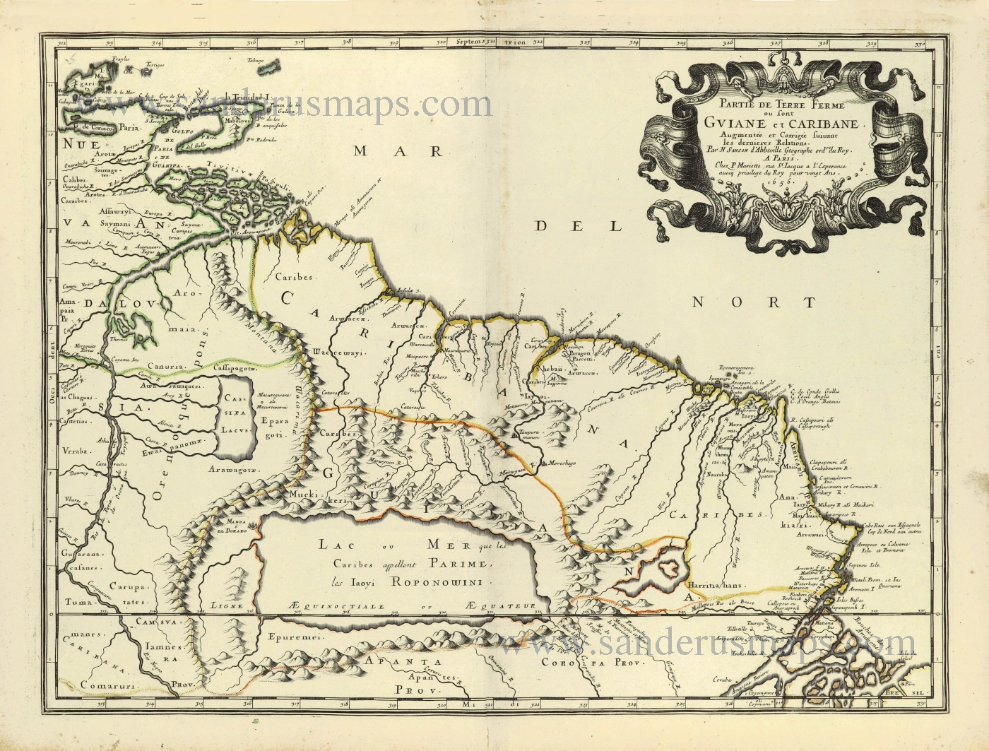
Partie de Terre Ferme ou sont Guiane et Caribane. 1658
Northeastern South America, by Nicolas Sanson.
[Item number: 28504]
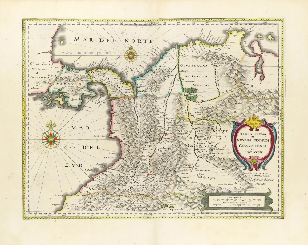
Terra Firma Et Novum Regnum Granatense Et Popayan. 1645
South America (Northwest) - Colombia by Willem Blaeu.
[Item number: 30181]