
Very rare second state, including the Tasman discoveries (Australia).
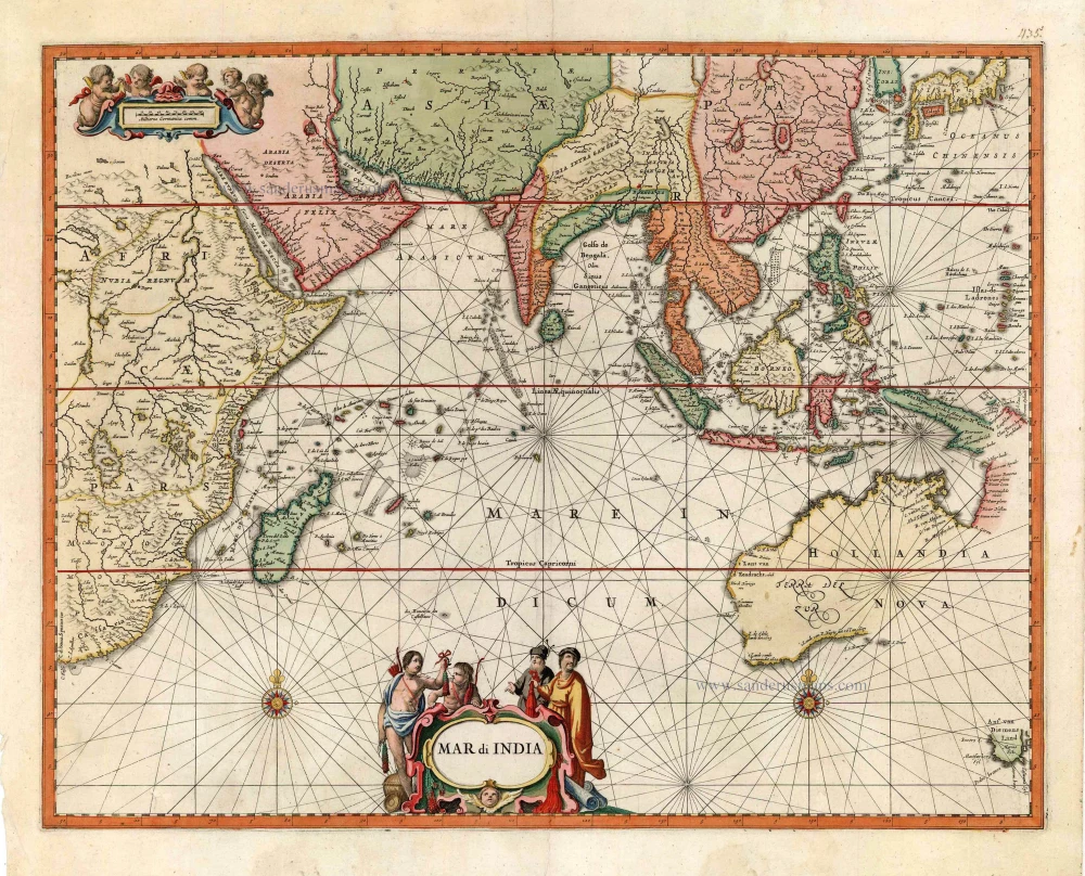
Indian Ocean, by Petrus Schenk c. 1700


Very rare: Unknown to Clancy (The Mapping of Terra Australis, 1995) and Schilder (Australia unveiled, 1976).
Revised edition, from about 1700, of a map which first appeared in 1650 and showed the Indian Ocean as it was known prior to Tasman's voyages. This edition includes Tasman's discoveries in North Australia and Tasmania.
The Schenk Family
Petrus Schenk (1660-1718), the founder of one of the best-known publishing firms of Amsterdam in the 18th century, was born in Elberfeld, Germany, in 1660. He went to Amsterdam where he became a pupil of the engraver Gerard Valck. On 19 Nov. 1686, a privilegio was granted to Petrus Schenk and Gerard Valk for the manufacturing and selling of their prints. Schenk’s contribution to cartography dates from c. 1695. In 1706 he moved to the Vijgendam in Amsterdam, ‘in Sanson’s Atlas’. After he died in 1718 his son, Leonardus Schenk, continued the art and print shop. The second son, Petrus II, settled in another famous house: ‘in Visscher’s Atlas’ where he continued the association with Gerard and Leonarus Valck.
The Schenk family produced general geographical atlases and special atlases. Apart from seventy original maps, several hundred are known with the name of Schenk, which were printed from plates obtained from Janssonius and Visscher. Schenk and Valck acquired all the plates of the Janssonius Heir’s Novus Atlas, Celestial atlas included. Many of Janssonius’ plates were reworked and amended.
The republishing of the maps from Janssonius’ Novus Atlas since c. 1680 was followed by the engraving of new maps, copied from Sanson’s better and more modern maps. Petrus Schenk published these maps in his Atlas Contractus sive mapparum geographicarum Sansoniarum auctarum et correctum Nova Congeries, also called Atlas Minor. After 1719, Petrus Schenk II continued the Atlas Contractus.
Petrus Schenk, the elder, enjoyed great fame as a print-seller and artist among art-and print-dealers in the whole of Europe. The great activity in map publishing, displayed by Petrus Schenk, the elder, was continued by his son and grandson. But the number of original atlas-maps is small. Like his father, who bought the copperplates of Janssonius’ atlas, Petrus Schenk II bought many of the plates formerly owned by Nicolaas Visscher.
Apart from the globes, maps and atlases, Petrus Schenk II published many books. He was older men of the booksellers guild in 1733.
The Janssonius Family
Joannes Janssonius (Arnhem, 1588-1664), son of the Arnhem publisher Jan Janssen, married Elisabeth Hondius, daughter of Jodocus Hondius, in Amsterdam in 1612. After his marriage, he settled down in this town as a bookseller and publisher of cartographic material. In 1618, he established himself in Amsterdam next door to Blaeu’s bookshop. He entered into serious competition with Willem Jansz. Blaeu when copying Blaeu’s Licht der Zeevaert after the expiration of the privilege in 1620. His activities concerned the publication of atlases, books, single maps, and an extensive book trade with branches in Frankfurt, Danzig, Stockholm, Copenhagen, Berlin, Koningsbergen, Geneva, and Lyon. In 1631, he began publishing atlases together with Henricus Hondius.
In the early 1640s, Henricus Hondius left the atlas publishing business to Janssonius. Competition with Joan Blaeu, Willem’s son and successor, in atlas production, prompted Janssonius to enlarge his Atlas Novus finally into a work of six volumes, into which a sea atlas and an atlas of the Old World were inserted. Other atlases published by Janssonius are Mercator’s Atlas Minor, Hornius’s historical atlas (1652), the townbooks in eight volumes (1657), Cellarius’s Atlas Coelestis and several sea atlases and pilot guides.
After the death of Joannes Janssonius, the shop and publishing firm were continued by the heirs under the direction of Johannes van Waesbergen (c. 1616-1681), son-in-law of Joannes Janssonius. Van Waesbergen added Janssonius's name to his own.
In 1676, Joannes Janssonius’s heirs sold by auction “all the remaining Atlases in Latin, French, High and Low German, as well as the Stedeboecken in Latin, in 8 volumes, bound and unbound, maps, plates belonging to the Atlas and Stedeboecken.” The copperplates from Janssonius’s atlases were afterwards sold to Schenk and Valck.
Mar di India.
Item Number: 27775 Authenticity Guarantee
Category: Antique maps > Asia > Southeast Asia
Very rare: Unknown to Clancy (The Mapping of Terra Australis, 1995) and Schilder (Australia unveiled, 1976).
Revised edition, from about 1700, of a map which first appeared in 1650 and showed the Indian Ocean as it was known prior to Tasman's voyages. This edition includes Tasman's discoveries in North Australia and Tasmania.
The Schenk Family
Petrus Schenk (1660-1718), the founder of one of the best-known publishing firms of Amsterdam in the 18th century, was born in Elberfeld, Germany, in 1660. He went to Amsterdam where he became a pupil of the engraver Gerard Valck. On 19 Nov. 1686, a privilegio was granted to Petrus Schenk and Gerard Valk for the manufacturing and selling of their prints. Schenk’s contribution to cartography dates from c. 1695. In 1706 he moved to the Vijgendam in Amsterdam, ‘in Sanson’s Atlas’. After he died in 1718 his son, Leonardus Schenk, continued the art and print shop. The second son, Petrus II, settled in another famous house: ‘in Visscher’s Atlas’ where he continued the association with Gerard and Leonarus Valck.
The Schenk family produced general geographical atlases and special atlases. Apart from seventy original maps, several hundred are known with the name of Schenk, which were printed from plates obtained from Janssonius and Visscher. Schenk and Valck acquired all the plates of the Janssonius Heir’s Novus Atlas, Celestial atlas included. Many of Janssonius’ plates were reworked and amended.
The republishing of the maps from Janssonius’ Novus Atlas since c. 1680 was followed by the engraving of new maps, copied from Sanson’s better and more modern maps. Petrus Schenk published these maps in his Atlas Contractus sive mapparum geographicarum Sansoniarum auctarum et correctum Nova Congeries, also called Atlas Minor. After 1719, Petrus Schenk II continued the Atlas Contractus.
Petrus Schenk, the elder, enjoyed great fame as a print-seller and artist among art-and print-dealers in the whole of Europe. The great activity in map publishing, displayed by Petrus Schenk, the elder, was continued by his son and grandson. But the number of original atlas-maps is small. Like his father, who bought the copperplates of Janssonius’ atlas, Petrus Schenk II bought many of the plates formerly owned by Nicolaas Visscher.
Apart from the globes, maps and atlases, Petrus Schenk II published many books. He was older men of the booksellers guild in 1733.
The Janssonius Family
Joannes Janssonius (Arnhem, 1588-1664), son of the Arnhem publisher Jan Janssen, married Elisabeth Hondius, daughter of Jodocus Hondius, in Amsterdam in 1612. After his marriage, he settled down in this town as a bookseller and publisher of cartographic material. In 1618, he established himself in Amsterdam next door to Blaeu’s bookshop. He entered into serious competition with Willem Jansz. Blaeu when copying Blaeu’s Licht der Zeevaert after the expiration of the privilege in 1620. His activities concerned the publication of atlases, books, single maps, and an extensive book trade with branches in Frankfurt, Danzig, Stockholm, Copenhagen, Berlin, Koningsbergen, Geneva, and Lyon. In 1631, he began publishing atlases together with Henricus Hondius.
In the early 1640s, Henricus Hondius left the atlas publishing business to Janssonius. Competition with Joan Blaeu, Willem’s son and successor, in atlas production, prompted Janssonius to enlarge his Atlas Novus finally into a work of six volumes, into which a sea atlas and an atlas of the Old World were inserted. Other atlases published by Janssonius are Mercator’s Atlas Minor, Hornius’s historical atlas (1652), the townbooks in eight volumes (1657), Cellarius’s Atlas Coelestis and several sea atlases and pilot guides.
After the death of Joannes Janssonius, the shop and publishing firm were continued by the heirs under the direction of Johannes van Waesbergen (c. 1616-1681), son-in-law of Joannes Janssonius. Van Waesbergen added Janssonius's name to his own.
In 1676, Joannes Janssonius’s heirs sold by auction “all the remaining Atlases in Latin, French, High and Low German, as well as the Stedeboecken in Latin, in 8 volumes, bound and unbound, maps, plates belonging to the Atlas and Stedeboecken.” The copperplates from Janssonius’s atlases were afterwards sold to Schenk and Valck.
Related items
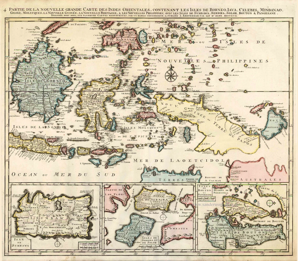
Partie de la Nouvelle Grande Carte des Indes Orientales, Contenant les Isles de Borneo, Iava, Celebes, Mindanao ... 1792
Indonesia - New Guinea - Australia by J.B. Elwe.
[Item number: 2293]
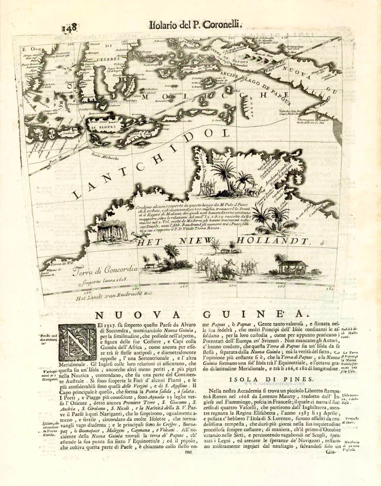
Nuova Guinea. 1696
Globe gore with Northern Australia and the East Indies, by V.M. Coronelli.
[Item number: 26448]
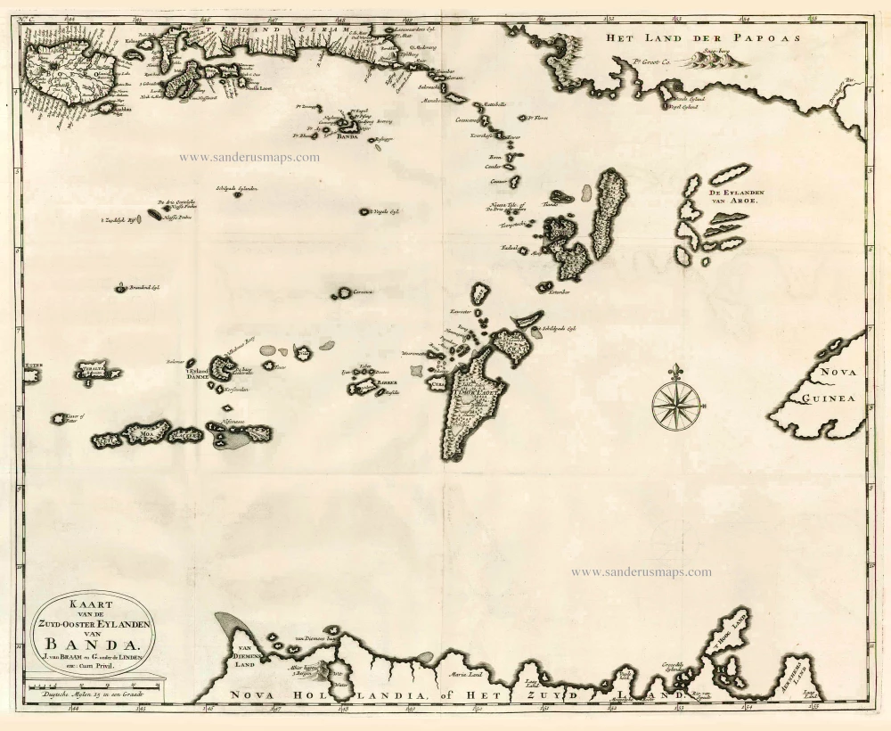
Kaart van de Zuyd-Ooster Eylanden van Banda. 1724-26
The Banda Islands (Southeast) & Northern Australia, by Fr. Valentyn.
[Item number: 26608]
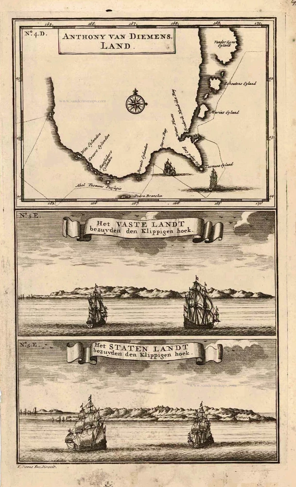
Anthony van Diemens Land | Het vaste Landt bezuyden den Klippigen hoek. | Het Staten Landt bezuyden den Klippigen hoek. 1726
Map and views of Tasmania, by François Valentyn.
[Item number: 27921]
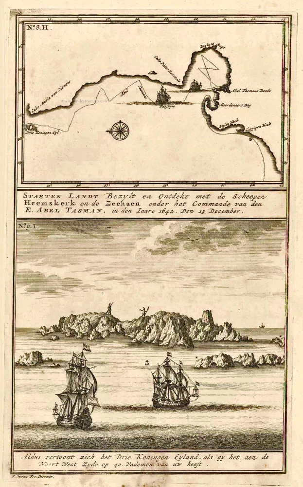
Staeten Landt Bezylt en Ontdekt met de Scheepen Heemskerk en de Zeehaen onder het Commande van den E. Abel Tasman. In den Iaare 1642. Den 13 December.. 1726
New Zealand, by François Valentyn.
[Item number: 27922]

Fries 1525 edition of the first modern map of Southeast Asia
Tab. Moderna Indiae. 1525
South Asia by Lorenz Fries.
[Item number: 27929]
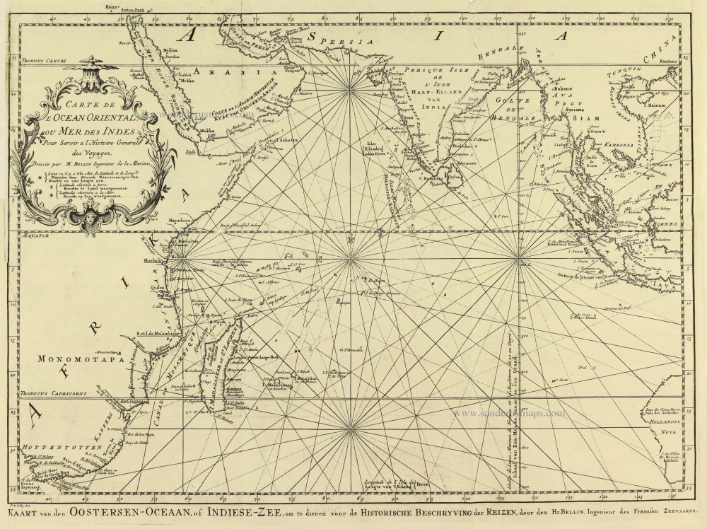
Carte de L'Ocean Oriental ou Mer des Indes. 1747
Indian Ocean by Jacques Nicolas Bellin.
[Item number: 28190]
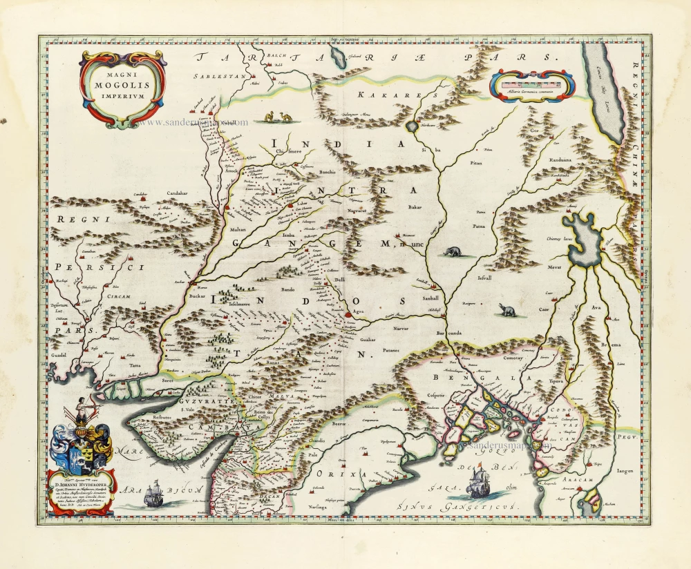
Magni Mogolis Imperium. 1640
India, by Joan Blaeu.
[Item number: 30140]