
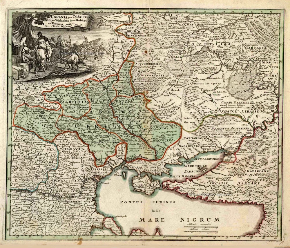
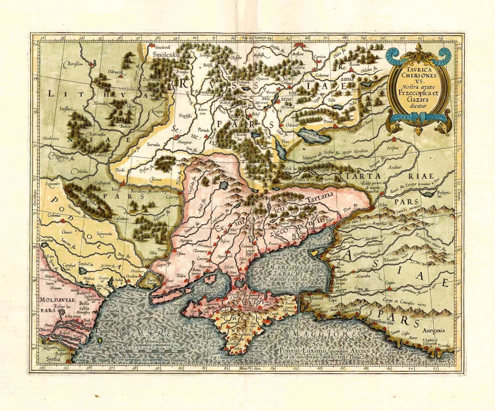
Ukraine by Christoph Weigel. 1718
Christoph Weigel the Elder (1654 -1725)
Christoph Weigel the Elder was a German engraver and publisher who learned the art of copperplate engraving in Augsburg. After various positions, including in Vienna and Frankfurt am Main, he acquired Nuremberg citizenship in 1698.
In Nuremberg, he worked very closely with the imperial geographer and cartographer Johann Baptist Homann to create his maps. He published 70 books and some series of engravings during his lifetime, including in 1718, the Atlas Scholasticus, followed in 1720 by Descriptio Orbis Antiquus; he also published a Reise Atlas in 1724 and an Atlas Manualis in the same year.
His younger brother Johann Christoph Weigel ran an art dealership in Nuremberg around the same time and was also very successful.
His widow continued Weigel's publishing house after 1725, who still published some of her deceased husband's works.
Ukrania seu Cosacorum Regio Walachia item Moldavia et Tartaria minor.
Item Number: 27908 Authenticity Guarantee
Category: Antique maps > Europe > Eastern Europe
Old, antique map of Ukraine with the Black Sea and the Crimea, by Christoph Weigel.
Title: Ukrania seu Cosacorum Regio Walachia item Moldavia et Tartaria minor.
exc: Christ: Weigelio Norib:
Cartographer: J.D. Kohler.
Engraver: Michael Kauffer.
Date of the first edition: 1718.
Date of this map: 1718.
Copper engraving, printed on paper.
Size (not including margins): 330 x 390mm (12.99 x 15.35 inches).
Verso: Blank.
Condition: Original coloured, excellent.
Condition Rating: A+.
References: Shirley (Brit.Lib), T.WEIG-1a (66)
From: Weigel Christoph. Atlas Scholasticus et Itinerarius. Nürnberg, J.E. Adelbulnern, 1718.
Second title: Johann David Köhlers ... Bequemer Schül-und Reisen-Atlas Aller Zu Erlernung der Alten, Mittlern und Neuen Geographie dienlichen Universal-und Particular-Charten ... ausgefertiger von Christoph Weigeln Kunsthändlern in Nürnberg ... Gedruckt bey Johann Ernst Adelbulnern. 1718.
Christoph Weigel the Elder (1654 -1725)
Christoph Weigel the Elder was a German engraver and publisher who learned the art of copperplate engraving in Augsburg. After various positions, including in Vienna and Frankfurt am Main, he acquired Nuremberg citizenship in 1698.
In Nuremberg, he worked very closely with the imperial geographer and cartographer Johann Baptist Homann to create his maps. He published 70 books and some series of engravings during his lifetime, including in 1718, the Atlas Scholasticus, followed in 1720 by Descriptio Orbis Antiquus; he also published a Reise Atlas in 1724 and an Atlas Manualis in the same year.
His younger brother Johann Christoph Weigel ran an art dealership in Nuremberg around the same time and was also very successful.
His widow continued Weigel's publishing house after 1725, who still published some of her deceased husband's works.
Related items
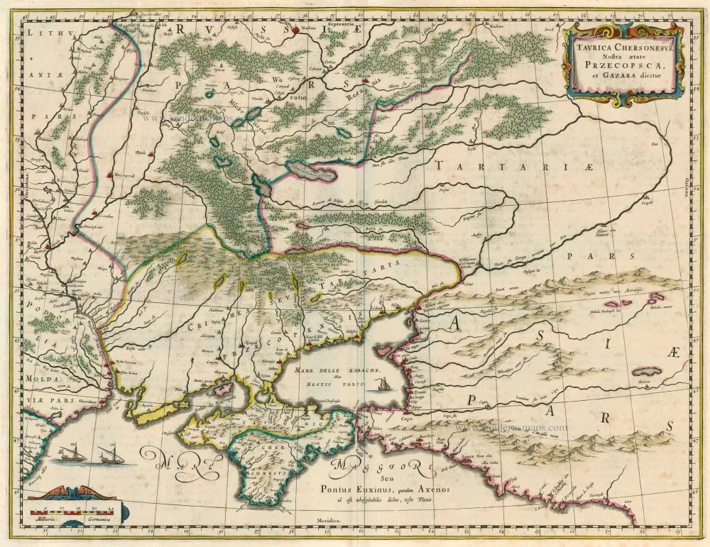
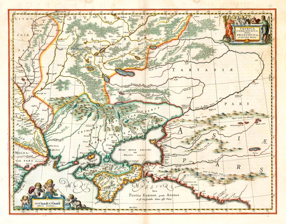
Taurica Chersonesus, Nostra aetate Przecopsca, et Gazara dicitur. 1662
Crimea, by Joan Blaeu.
[Item number: 23147]
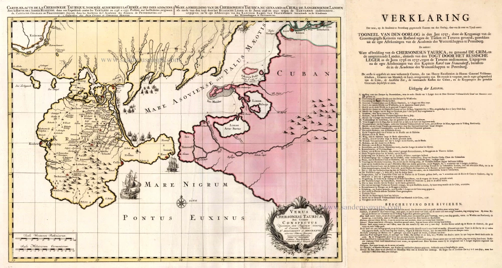
Carte Exacte de la Chersonese Taurique ... avec la Route de l'Armee Russienne ... 1736 & 1737 1721-41
Crimea, by Covens & Mortier.
[Item number: 23582]
Taurica Chersonesus VS. nostra Aetate Przecopsca et Gazara Dicitur. 1641
Ukraine - Crimea by Henricus Hondius.
[Item number: 26264]
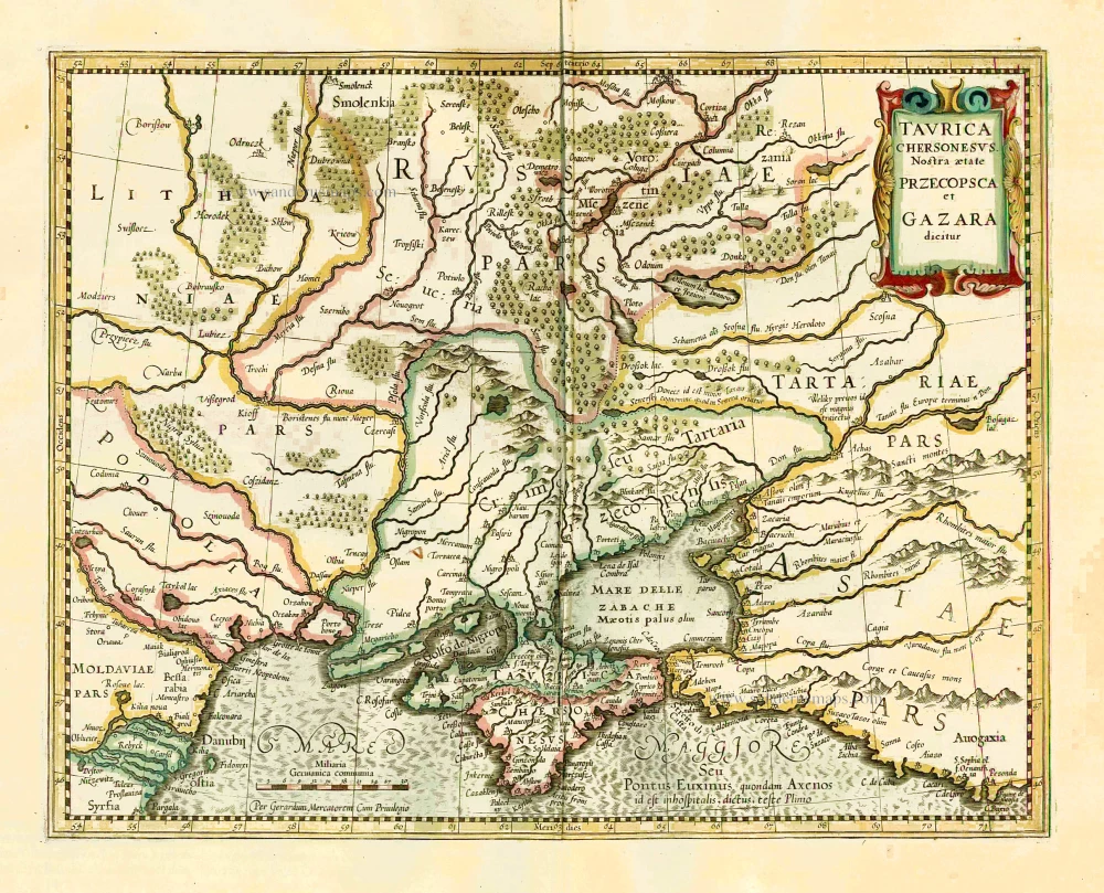
Taurica Chersonesus, Hodie Przecosca, et Gazara dicitur. 1647-56
Crimea, by Johannes Janssonius.
[Item number: 26743]

Carte de la Lithuanie Russienne qui Comprend les Palatinats de Livonie, de Witepsk, de Miscislaw, et une Partie de ceux de Polock et de Minsk Cédés par la Pologne a la Russie. 1776-79
Bellarus and parts of Lithuania and Ukraine, by Francesco Santini.
[Item number: 26969]
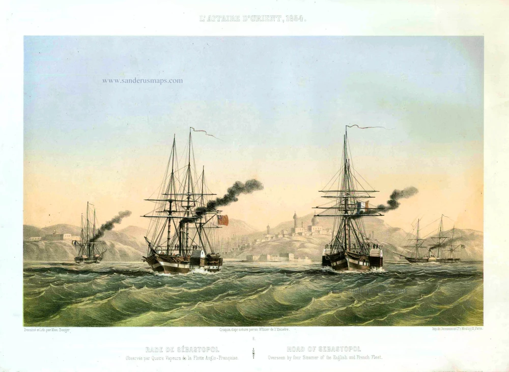
Rade de Sébastopol. Observée par quatre Vapeurs de la Flotte Anglo-Française. / Road of Sebastopol. Overseen by four Steamer of the English and French Fleet. 1854
Sebastopol (Ukraine), by Max Beeger.
[Item number: 27436]
Taurica Chersonesus VS. nostra Aetate Przecopsca et Gazara Dicitur. 1633
Crimea by Gerard Mercator.
[Item number: 27745]

Cimmeria quae Postea Scythia Europaea Seu Parua Scythia. 1665
Ukraine, by Nicolas Sanson.
[Item number: 27919]
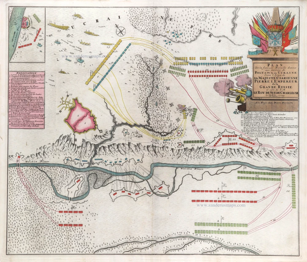
Plan de la fameuse Bataille donnee aux environs de Poltawa en Ucraine Entre l'Armee de sa Majesté Csarienne Pierre I. Empereur de la Grande Russie et celle de S.M. le Roy de Suede Charles XII. me 27 Juin -8 Jullet 1709. c. 1709
Map of the Battle of Poltawa (Ukraine) in 1709, by Pierre Husson.
[Item number: 29587]