Asia, by Caius Julius Solinus. 1543
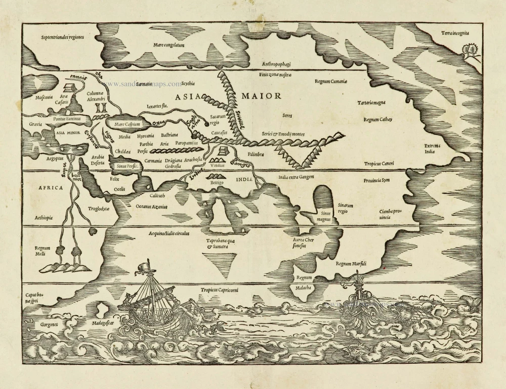
The top right corner of this Asia map depicts a northwest-orientated coastline labelled Terra incognita. This is the earliest representation of the northwest coast of America on a printed map, showing only a few trees, hills and a small bay. Its existence has caused much debate; not even the cartographer is known for sure, although it is most often thought to be the work of Sebastian Münster, who compiled the book's text. The text opposite the map, on page 150, refers to this coast, 'In our days it has been explored by men'; however, no such voyage is known today. Wagner suggests that it might represent Japan; if so, this would be five years before the earliest recorded visit by a European. It also shows one of the first delineations of a strait between Asia and America some 200 years before Vitus Bering's voyage to this area. There was a debate about a possible land mass connection to the American continent. (Burden)
Gaius Julius Solinus was a Latin grammarian, geographer, and compiler who probably flourished in the early 3rd century AD.
Solinus was the author of De mirabilibus mundi ("The wonders of the world") which circulated both under the title Collectanea rerum memorabilium ("Collection of Curiosities"), and Polyhistor.
Asia Maior.
Item Number: 28081 Authenticity Guarantee
Category: Antique maps > America > North America
Old, antique map of Asia, by Caius Julius Solinus.
Title: Asia Maior.
Cartographer: Sebastian Münster.
Date of the first edition: 1538.
Date of this map: 1543.
Woodcut, printed on paper.
Map size: 245 x 330mm (9.65 x 12.99 inches).
Sheet size: 300 x 370mm (11.81 x 14.57 inches).
Verso: Blank.
Condition: Excellent.
Condition Rating: A+.
From: SOLINUS, Caius Julius. Polyhistor rerum toto orbe memorabilium thesaurus locupletissimus. Basel, Heinrich Petri, 1543.
The top right corner of this Asia map depicts a northwest-orientated coastline labelled Terra incognita. This is the earliest representation of the northwest coast of America on a printed map, showing only a few trees, hills and a small bay. Its existence has caused much debate; not even the cartographer is known for sure, although it is most often thought to be the work of Sebastian Münster, who compiled the book's text. The text opposite the map, on page 150, refers to this coast, 'In our days it has been explored by men'; however, no such voyage is known today. Wagner suggests that it might represent Japan; if so, this would be five years before the earliest recorded visit by a European. It also shows one of the first delineations of a strait between Asia and America some 200 years before Vitus Bering's voyage to this area. There was a debate about a possible land mass connection to the American continent. (Burden)
Gaius Julius Solinus was a Latin grammarian, geographer, and compiler who probably flourished in the early 3rd century AD.
Solinus was the author of De mirabilibus mundi ("The wonders of the world") which circulated both under the title Collectanea rerum memorabilium ("Collection of Curiosities"), and Polyhistor.