
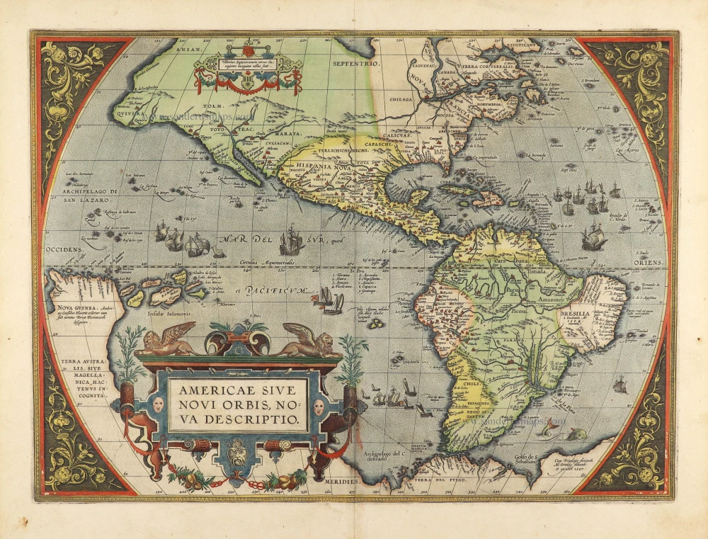
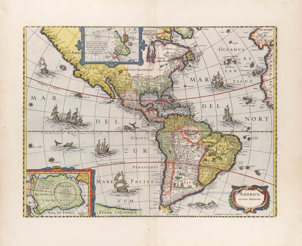
America by Jodocus Hondius. 1613
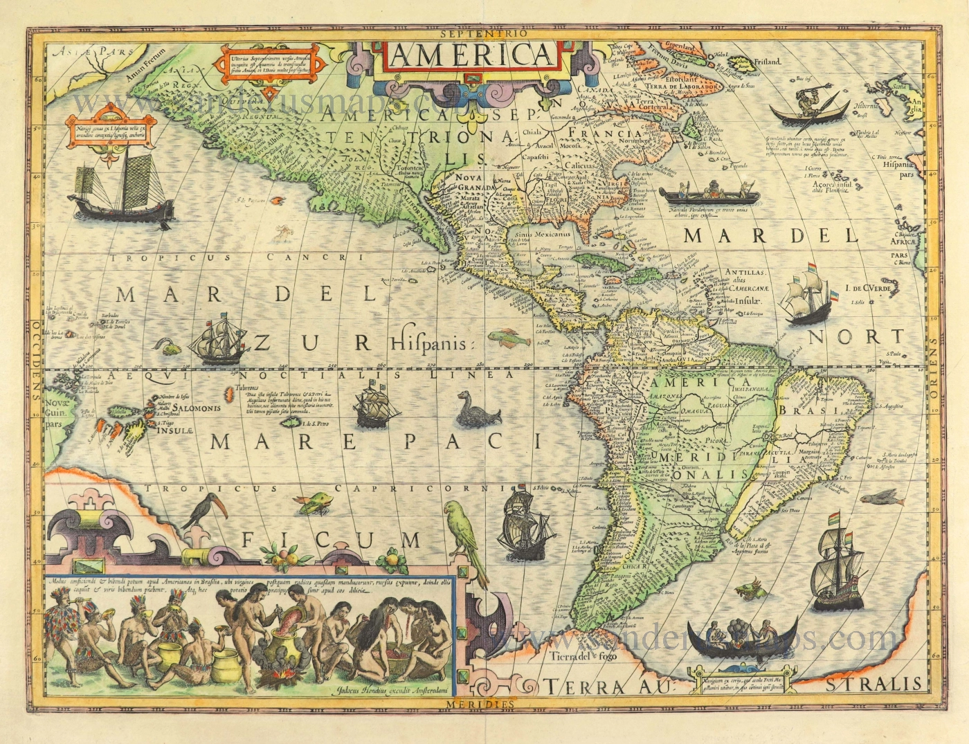
"Jodocus Hondius engraved this map for his first edition of Gerard Mercator's atlas. It was intended to be a grand comprehensive work, with the first part appearing in 1585. However, by Mercator's death in 1594, only two parts had been published. Continued by his family, it was still incomplete for the 1602 edition, lacking, most notably, a section on the Iberian peninsula. During this time, it was also competing with the remarkably successful atlas of Abraham Ortelius, which averaged almost one edition per year. By 1604 Jodocus Hondius was flourishing and acquired all of the plates from Mercator's descendants. He immediately set about engraving many new maps to augment and complete the work, amongst which was a set of the four continents. He also had the original text expanded by Petrus Montanus. In the following year, he brought out Mercator's Ptolemy, and in 1606 his first edition of the general atlas proved instantly popular, selling out within a year.
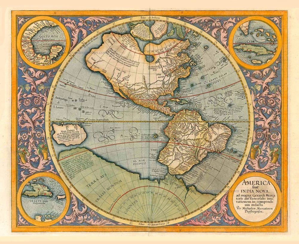
Until 1630, this attractive map was issued alongside the AMERICA sive INDIA NOVA by Michael Mercator 1595. Since the Mercator always used the text describing America, this one is always lacking. Produced on a stereographic projection like more and more maps of the time, it is an amalgam of various sources. It incorporates a correct west coast of South America. It narrows the longitudinal width of New Spain at the Tropic of Cancer, making it just 10°, much closer to reality. However, like all cartography, it retains an enlarged North American continent. A Plancius-type depiction of Newfoundland occurs alongside a typical period representation of the east coast, with a more protruding Virginia than usual. Various scenes from the earlier volumes of de Bry's Grand Voyages adorn the whole. Particularly notable is the native Brazilian scene illustrating making a local beverage, derived from Hans Staden's voyage as recorded by de Bry. There are various ships, kayaks and Indian canoes, along with a pair of birds perched on the inset." (Burden)
Gerard Mercator (1512 – 1594)
Gerard Mercator was born Gerard de Cremere in Rupelmonde (near Antwerp) on 5 March 1512.
Young Gerard learned what Latin he could in Rupelmonde, and when he was about fifteen, his uncle sent him to s'Hertogenbosch to study at a school run by the Brothers of the Common Life. One of Mercator’s teachers was the celebrated humanist Macropedius. After three and a half years with the brothers, Gerard went to Louvain, where he enrolled in the university in 1530 as one of the poor students at Castle College.
By this time, he had Latinized his name to Mercator. He studied philosophy and took his master’s degree in 1532. The problems of the creation of the Universe and the Earth interested him in particular; this is reflected by his works written in later years.
After spending a few years in Antwerp, he returned to Louvain in c. 1535, where he took courses in mathematics under Gemma Frisius. Soon, he was recognised as an expert on the construction of mathematical instruments, as a land surveyor and, after 1537, as a cartographer. He drew his income from these activities after his marriage on August 3, 1536. He also qualified himself as a copper engraver, the first to introduce italic handwriting to this trade. The first maps, drawn and engraved by Gerard Mercator, are Palestine, 1537; the World in double heart-shaped projection, 1538; and Flanders, 1540.
In 1544, Mercator came into great danger: he was arrested on the accusation of heresy and put into jail. Thanks to the intervention of the University of Louvain, he was released after four months. In 1552, he moved with his family to Duisburg (Germany). In 1560, Mercator became a cosmographer in service of the Duke of Jülich-Cleve-Berge, and in 1563, he became a lecturer at the Grammar School of the new University in Duisburg. During this period, he made wall maps of Europe, 1554; of Loraine, 1564; the British Isles, 1564; and the famous world map with increasing latitudes, 1569. About this time, Mercator was also working on the project for a complete description of the creation, the Heavens, Earth, Sea and world history. This resulted in his Atlas, sive cosmographicae meditationes de fabrica mundi et fabricati figura. He also worked on an edition of Ptolemy’s Geographia, which appeared in 1578. The first part of his book with modern maps (France, Germany and the Netherlands) appeared in 1585.
Shortly after the publication of the second part of his map book (not yet called Atlas) with the maps of Italy (1589), he had a stroke that ended his highly significant productivity. The great man passed away on 2 December 1594, leaving the responsibility of finishing the map book to his son Rumold. The final part of it appeared in 1595. Its title is Pars Altera, and it constitutes an essential part of what was then called Mercator’s Atlas.
The map of Europe and the world map in the Atlas are by Rumold Mercator. After Rumold died in 1599, the Atlas was reissued in 1602.
The plates of the maps, both of the Ptolemy edition and the Atlas, were sold in 1604 to Jodocus Hondius of Amsterdam. The following year, Hondius managed to bring out Ptolemy’s Geographia. In 1606, the first Amsterdam edition of the Mercator Atlas appeared in the next year. From then to 1638, the Atlas saw many enlarged editions in various languages.
America.
Item Number: 28530 Authenticity Guarantee
Category: Antique maps > America > The Americas
Old, antique map of America, by Jodocus Hondius.
With an inset showing a scene of Indians preparing the fermented brew.
Title: America.
Jodocus Hondius excudit Amsterodami.
Date of the first edition: 1606.
Date of this map: 1613.
Copper engraving, printed on paper.
Map size: 375 x 505mm (14.76 x 19.88 inches).
Sheet size: 440 x 540mm (17.32 x 21.26 inches).
Verso: Latin text.
Condition: Original coloured, a few small verdigris cracks skillfully repaired.
Condition Rating: A
References: Van der Krogt 1, 9000:1B; Burden, #150; Wagner, #245; Portinaro & Knirsch, LXXIII.
From: Gerardi Mercatoris - Atlas sive Cosmographicae Meditationes de Fabrica Mundi et Fabricati Figura. Editio Quarta. Amsterdam, J. Hondius, 1613. (Van der Krogt 1:104)
"Jodocus Hondius engraved this map for his first edition of Gerard Mercator's atlas. It was intended to be a grand comprehensive work, with the first part appearing in 1585. However, by Mercator's death in 1594, only two parts had been published. Continued by his family, it was still incomplete for the 1602 edition, lacking, most notably, a section on the Iberian peninsula. During this time, it was also competing with the remarkably successful atlas of Abraham Ortelius, which averaged almost one edition per year. By 1604 Jodocus Hondius was flourishing and acquired all of the plates from Mercator's descendants. He immediately set about engraving many new maps to augment and complete the work, amongst which was a set of the four continents. He also had the original text expanded by Petrus Montanus. In the following year, he brought out Mercator's Ptolemy, and in 1606 his first edition of the general atlas proved instantly popular, selling out within a year.
Until 1630, this attractive map was issued alongside the AMERICA sive INDIA NOVA by Michael Mercator 1595. Since the Mercator always used the text describing America, this one is always lacking. Produced on a stereographic projection like more and more maps of the time, it is an amalgam of various sources. It incorporates a correct west coast of South America. It narrows the longitudinal width of New Spain at the Tropic of Cancer, making it just 10°, much closer to reality. However, like all cartography, it retains an enlarged North American continent. A Plancius-type depiction of Newfoundland occurs alongside a typical period representation of the east coast, with a more protruding Virginia than usual. Various scenes from the earlier volumes of de Bry's Grand Voyages adorn the whole. Particularly notable is the native Brazilian scene illustrating making a local beverage, derived from Hans Staden's voyage as recorded by de Bry. There are various ships, kayaks and Indian canoes, along with a pair of birds perched on the inset." (Burden)
Gerard Mercator (1512 – 1594)
Gerard Mercator was born Gerard de Cremere in Rupelmonde (near Antwerp) on 5 March 1512.
Young Gerard learned what Latin he could in Rupelmonde, and when he was about fifteen, his uncle sent him to s'Hertogenbosch to study at a school run by the Brothers of the Common Life. One of Mercator’s teachers was the celebrated humanist Macropedius. After three and a half years with the brothers, Gerard went to Louvain, where he enrolled in the university in 1530 as one of the poor students at Castle College.
By this time, he had Latinized his name to Mercator. He studied philosophy and took his master’s degree in 1532. The problems of the creation of the Universe and the Earth interested him in particular; this is reflected by his works written in later years.
After spending a few years in Antwerp, he returned to Louvain in c. 1535, where he took courses in mathematics under Gemma Frisius. Soon, he was recognised as an expert on the construction of mathematical instruments, as a land surveyor and, after 1537, as a cartographer. He drew his income from these activities after his marriage on August 3, 1536. He also qualified himself as a copper engraver, the first to introduce italic handwriting to this trade. The first maps, drawn and engraved by Gerard Mercator, are Palestine, 1537; the World in double heart-shaped projection, 1538; and Flanders, 1540.
In 1544, Mercator came into great danger: he was arrested on the accusation of heresy and put into jail. Thanks to the intervention of the University of Louvain, he was released after four months. In 1552, he moved with his family to Duisburg (Germany). In 1560, Mercator became a cosmographer in service of the Duke of Jülich-Cleve-Berge, and in 1563, he became a lecturer at the Grammar School of the new University in Duisburg. During this period, he made wall maps of Europe, 1554; of Loraine, 1564; the British Isles, 1564; and the famous world map with increasing latitudes, 1569. About this time, Mercator was also working on the project for a complete description of the creation, the Heavens, Earth, Sea and world history. This resulted in his Atlas, sive cosmographicae meditationes de fabrica mundi et fabricati figura. He also worked on an edition of Ptolemy’s Geographia, which appeared in 1578. The first part of his book with modern maps (France, Germany and the Netherlands) appeared in 1585.
Shortly after the publication of the second part of his map book (not yet called Atlas) with the maps of Italy (1589), he had a stroke that ended his highly significant productivity. The great man passed away on 2 December 1594, leaving the responsibility of finishing the map book to his son Rumold. The final part of it appeared in 1595. Its title is Pars Altera, and it constitutes an essential part of what was then called Mercator’s Atlas.
The map of Europe and the world map in the Atlas are by Rumold Mercator. After Rumold died in 1599, the Atlas was reissued in 1602.
The plates of the maps, both of the Ptolemy edition and the Atlas, were sold in 1604 to Jodocus Hondius of Amsterdam. The following year, Hondius managed to bring out Ptolemy’s Geographia. In 1606, the first Amsterdam edition of the Mercator Atlas appeared in the next year. From then to 1638, the Atlas saw many enlarged editions in various languages.
Related items
Americae nova Tabula. 1647-49
America, by Willem Blaeu.
[Item number: 6717]

America 1602
America by Langenes, published by Bertius P.
[Item number: 12494]
America Sive Novus Orbis Respectu Europaeorum Inferior Globi Terrestri Pars. 1596. 1596
The Americas by Theodore de Bry.
[Item number: 12546]
California as an island
La Division de l'Ocean du Nouveau Monde 1648
America, by Briet Ph.
[Item number: 17771]
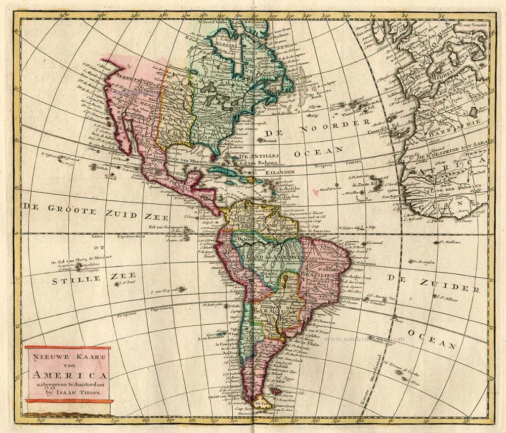
Nieuwe Kaart van America c. 1770
Antique map of America by Tirion I.
[Item number: 19194]

America. 1597
AMERICA by Giovanni Magini
[Item number: 22492]
Americae Sive Novi Orbis, Nova Descriptio. 1598
America, by Abraham Ortelius.
[Item number: 25618]
Americae tam Septentrionalis quam Meridionalis in Mappa Geographica Delineatio. c. 1700
America by A.F. Zürner, published by Petrus Schenk.
[Item number: 25715]
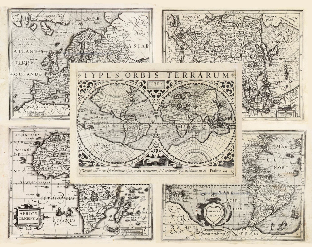
Typus Orbis Terrarum, [in set with:] Europa, [and] Asia, [and] Americae Descrip., [and] Africae Descriptio. 1607
World + Continents, by Jodocus Hondius.
[Item number: 27088]
Americae Sive Novi Orbis, Nova Descriptio. 1603
America by Abraham Ortelius.
[Item number: 27538]
America sive India Nova. 1623
America, by Gerard Mercator.
[Item number: 27752]
Original Halma edition.
L'Amerique selon les Nouvelles Observations de Messrs. de l'Academie des Sciences, etc. Before 1713
America, by François Halma.
[Item number: 28017]
Novissima et Accuratissima Septentrionalis ac Meridionalis Americae. c. 1715
America by Frederick de Wit, published by Covens & Mortier.
[Item number: 28295]
California as an island
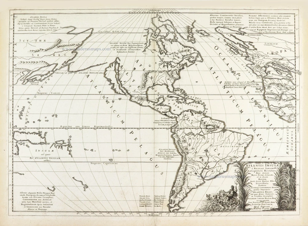
Atlantis Insula. 1692
The Americas by Guillaume Sanson.
[Item number: 28376]
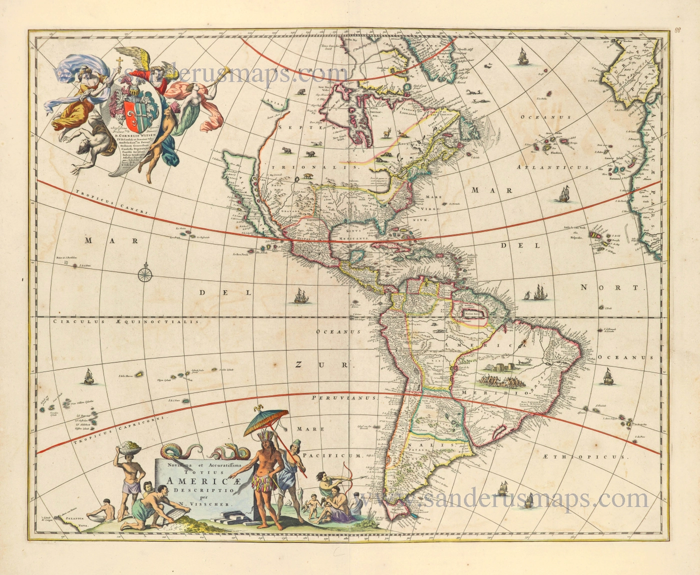
Novissima et Accuratissima Totius Americae Descriptio. 1656-77
America by Nicolaes Visscher I.
[Item number: 28554]
First plate
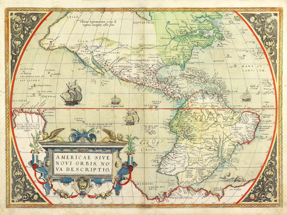
Americae Sive Novi Orbis, Nova Descriptio. 1572
America by Abraham Ortelius.
[Item number: 29237]
One of the most elaborately engraved maps ever published.
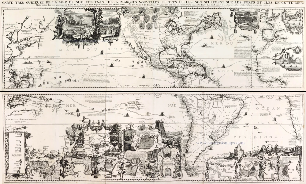
Carte tres Curieuse de la Mer du Sud, Contenant des Remarques Nouvelles et tres Utiles non Seulement sur les Ports et Iles de cette Mer, 1719
Pacific by Zacharias Châtelain after Nicolas de Fer.
[Item number: 29466]
Luxury colour.
America noviter delineata. 1666
America by Jodocus Hondius Jr, published by Joannes Janssonius.
[Item number: 29790]
First state
Atlantis Insula. 1667-69
The Americas and the Pacific and Atlantic Ocean by Guillaume Sanson.
[Item number: 29999]
Le table des neufues lesquelles on appelle isles d'Occident & d'Indie pour divers regard. 1555
America by Sebastian Münster.
[Item number: 30379]
new
Le table des neufues lesquelles on appelle isles d'Occident & d'Indie pour divers regard. 1568
America by Sebastian Münster.
[Item number: 30518]