
World by Nicolaas Visscher, double hemisphere. c. 1678

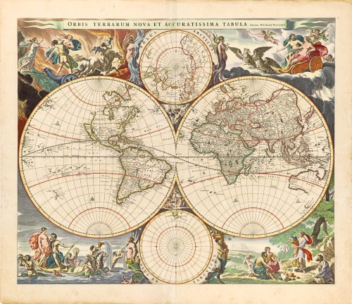
Nicolaas Visscher's new world map in two hemispheres can be regarded as the master forerunner of several highly decorative Dutch world maps produced throughout the remainder of the century. ... The distinctive attractiveness of many of the later seventeenth-century Dutch world maps is to be found in their border decorations, and Visscher's is no exception. His artist Nicolaes Berchem has introduced dramatic classical scenes representing the rape of Persephone, Zeus being carried across the heavens in an eagle-drawn chariot, Poseidon commanding his entourage, and Demeter receiving the fruits of the Earth. At the top and bottom are smaller spheres with projections based on the north and south poles; on the latter, only the tip of South America can be seen. (Shirley)
The Visscher Family
For nearly a century, the members of the Visscher family were essential art dealers and map publishers in Amsterdam.
Claes Jansz. Visscher, or N.J. Piscator (1587-1652)
Claes Jansz. Vischer bought a house in Amsterdam, 'de gulden Bors', on the crucial Kalverstraat and changed the name into "In de Visscher"; under this title, the shop was to flourish for many years.
He was famous for his engravings and etchings of Dutch landscapes and 'historical scenes', such as sieges, battles, etc. These 'historical scenes' were considered contemporary illustrated news items, especially e.g. that of 'the Eighty Years' War'.
For the publication of his first atlas, he bought copperplates of the atlas Germania Inferior by Pieter van den Keere (1623).
In 1649, he published an atlas entitled Tabularum Geographicarum Contractarum, containing the same maps as Langenes' Caert Thresoor, for which Visscher had only new title pages engraved.
Claes Jansz. Visscher died in 1652. His wife, Neeltjen Florisdr., had already died in 1640. They had seven children, four of whom were still alive at Claes Jansz.'s death. One was Nicolaes Visscher I, who was to continue his father's business.
Nicolaes Visscher I (1618-1679)
Nicolaes Visscher I partnered with his father, continued the business, and stayed on the Kalverstraat 'in de Visscher' till his death.
In about 1657, the first edition of his Atlas Contractus Orbis Terrarum appeared.
Between 1664 and 1677, several editions of his Atlas Contractus appeared without a printed index, for these atlases had no fixed contents but were composed according to the buyer's financial leaping pole.
In May 1664, Nicolaes Visscher was admitted as a member of the Booksellers' Guild of his town. In July 1677, he was granted a patent of the States of Holland and West-Friesland for printing and publishing maps and atlases for 15 years.
After this, he again published an Atlas Contractus with a printed index. At about the same time, he also brought out an Atlas Minor.
Nicolaes Visscher II (1649-1702)
Nicolaes Visscher II inherited the 'shop' from his father. To obtain a new privilege, he applied to the States of Holland and West-Friesland in 1682 for a patent for printing and publishing maps. This patent was granted to him the same year. He moved the firm to the Dam, but it kept the same signboard: "In de Visscher".
Around 1683, he published his first Atlas Minor with a printed index of 91 maps. In 1684, an atlas Germania Inferior appeared. Till 1697, he published another number of atlases. He used his grandfather's (Claes Jansz.) maps less often now and relied more and more on his own.
The wars waged at this time initiated the compilation of maps of the countries where the armies operated. Many war maps were included in the various editions of his Atlas Minor.
After Nicolaes's death, his wife, Elizabeth Verseyl, published all the war maps as an atlas under the title De Stoel des Oorlogs in de Wereld (The seat of war in the world).
The widow of Nicolaes Visscher II (?-1726)
His widow continued the business energetically, and by her hand, under the name of her deceased husband, numerous atlases appeared, e.g., several editions of the Atlas Minor, an Atlas Maior and De Stoel des Oorlogs. The shop enjoyed a high reputation due to the assortment's incredible variety. Not only 'Visscher' maps but also maps of other publishers were obtainable. With the death of Elizabeth Verseyl in 1726, the last descendant died of a great map- and atlas-publishing firm in Amsterdam.
Orbis Terrarum Nova et Accuratissima Tabula.
Item Number: 28628 Authenticity Guarantee
Category: Antique maps > World and Polar
Antique world map - double-hemisphere by N. Visscher, with smaller polar projections at top and bottom and allegorical surrounds.
Title: Orbis Terrarum Nova et Accuratissima Tabula.
Auctore Nicolao Visscher.
N.P. Berchem invent.
Designer: Nicolaes Pieterszoon Berchem.
Date of the first edition: 1658.
Date of this map: c. 1678.
Copper engraving, printed on paper.
Map size: 470 x 560mm (18.5 x 22.05 inches).
Sheet size: 540 x 615mm (21.26 x 24.21 inches).
Verso: Blank.
Condition: Original coloured, lower centrefold split reinforced.
Condition Rating: A.
References: Shirley (World), #406
From: Atlas Contractus Orbis Terrarum Praecipuas ac Novissimas Complectens Tabulas. Amsterdam, N. Visccher, 1656-77. (Koeman III, Vis5-8)
Nicolaas Visscher's new world map in two hemispheres can be regarded as the master forerunner of several highly decorative Dutch world maps produced throughout the remainder of the century. ... The distinctive attractiveness of many of the later seventeenth-century Dutch world maps is to be found in their border decorations, and Visscher's is no exception. His artist Nicolaes Berchem has introduced dramatic classical scenes representing the rape of Persephone, Zeus being carried across the heavens in an eagle-drawn chariot, Poseidon commanding his entourage, and Demeter receiving the fruits of the Earth. At the top and bottom are smaller spheres with projections based on the north and south poles; on the latter, only the tip of South America can be seen. (Shirley)
The Visscher Family
For nearly a century, the members of the Visscher family were essential art dealers and map publishers in Amsterdam.
Claes Jansz. Visscher, or N.J. Piscator (1587-1652)
Claes Jansz. Vischer bought a house in Amsterdam, 'de gulden Bors', on the crucial Kalverstraat and changed the name into "In de Visscher"; under this title, the shop was to flourish for many years.
He was famous for his engravings and etchings of Dutch landscapes and 'historical scenes', such as sieges, battles, etc. These 'historical scenes' were considered contemporary illustrated news items, especially e.g. that of 'the Eighty Years' War'.
For the publication of his first atlas, he bought copperplates of the atlas Germania Inferior by Pieter van den Keere (1623).
In 1649, he published an atlas entitled Tabularum Geographicarum Contractarum, containing the same maps as Langenes' Caert Thresoor, for which Visscher had only new title pages engraved.
Claes Jansz. Visscher died in 1652. His wife, Neeltjen Florisdr., had already died in 1640. They had seven children, four of whom were still alive at Claes Jansz.'s death. One was Nicolaes Visscher I, who was to continue his father's business.
Nicolaes Visscher I (1618-1679)
Nicolaes Visscher I partnered with his father, continued the business, and stayed on the Kalverstraat 'in de Visscher' till his death.
In about 1657, the first edition of his Atlas Contractus Orbis Terrarum appeared.
Between 1664 and 1677, several editions of his Atlas Contractus appeared without a printed index, for these atlases had no fixed contents but were composed according to the buyer's financial leaping pole.
In May 1664, Nicolaes Visscher was admitted as a member of the Booksellers' Guild of his town. In July 1677, he was granted a patent of the States of Holland and West-Friesland for printing and publishing maps and atlases for 15 years.
After this, he again published an Atlas Contractus with a printed index. At about the same time, he also brought out an Atlas Minor.
Nicolaes Visscher II (1649-1702)
Nicolaes Visscher II inherited the 'shop' from his father. To obtain a new privilege, he applied to the States of Holland and West-Friesland in 1682 for a patent for printing and publishing maps. This patent was granted to him the same year. He moved the firm to the Dam, but it kept the same signboard: "In de Visscher".
Around 1683, he published his first Atlas Minor with a printed index of 91 maps. In 1684, an atlas Germania Inferior appeared. Till 1697, he published another number of atlases. He used his grandfather's (Claes Jansz.) maps less often now and relied more and more on his own.
The wars waged at this time initiated the compilation of maps of the countries where the armies operated. Many war maps were included in the various editions of his Atlas Minor.
After Nicolaes's death, his wife, Elizabeth Verseyl, published all the war maps as an atlas under the title De Stoel des Oorlogs in de Wereld (The seat of war in the world).
The widow of Nicolaes Visscher II (?-1726)
His widow continued the business energetically, and by her hand, under the name of her deceased husband, numerous atlases appeared, e.g., several editions of the Atlas Minor, an Atlas Maior and De Stoel des Oorlogs. The shop enjoyed a high reputation due to the assortment's incredible variety. Not only 'Visscher' maps but also maps of other publishers were obtainable. With the death of Elizabeth Verseyl in 1726, the last descendant died of a great map- and atlas-publishing firm in Amsterdam.
Related items

A fine ornate example of the decorative cartography of the time.
Nova Totius Terrarum Orbis Geographica ac Hydrographica Tabula. Auct: Henr: Hondio. 1641
Double-hemisphere world map by Henricus Hondius.
[Item number: 28768]
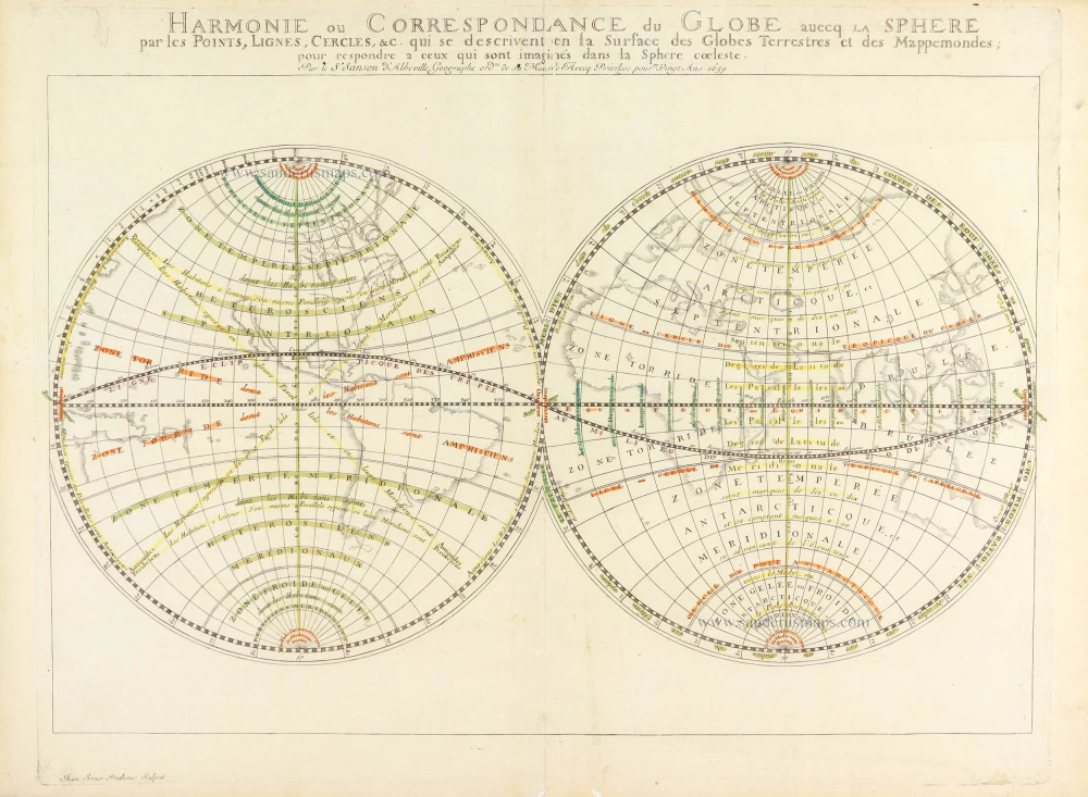
Harmonie ou Correspondance du globe avecq la sphere par les points, lignes, cercles, etc. qui se descrivent en la surface du globe terrestres et des mappemondes; pour respondre a ceux qui sont imaginés dans la sphere coeleste. 1659
World in two hemispheres, by Nicolas Sanson.
[Item number: 28886]

Luxury colouring.
Orbis Terrarum Nova et Accuratissima Tabula. c. 1678
Double-hemisphere world map, by Nicolaas Visscher I.
[Item number: 28934]
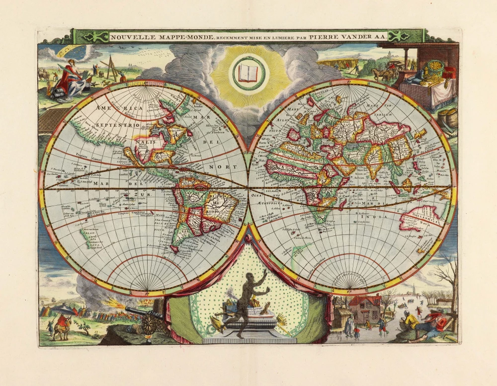
Nouvelle Mappe-Monde, 1710
World by Pieter Van der Aa, double hemisphere.
[Item number: 29136]
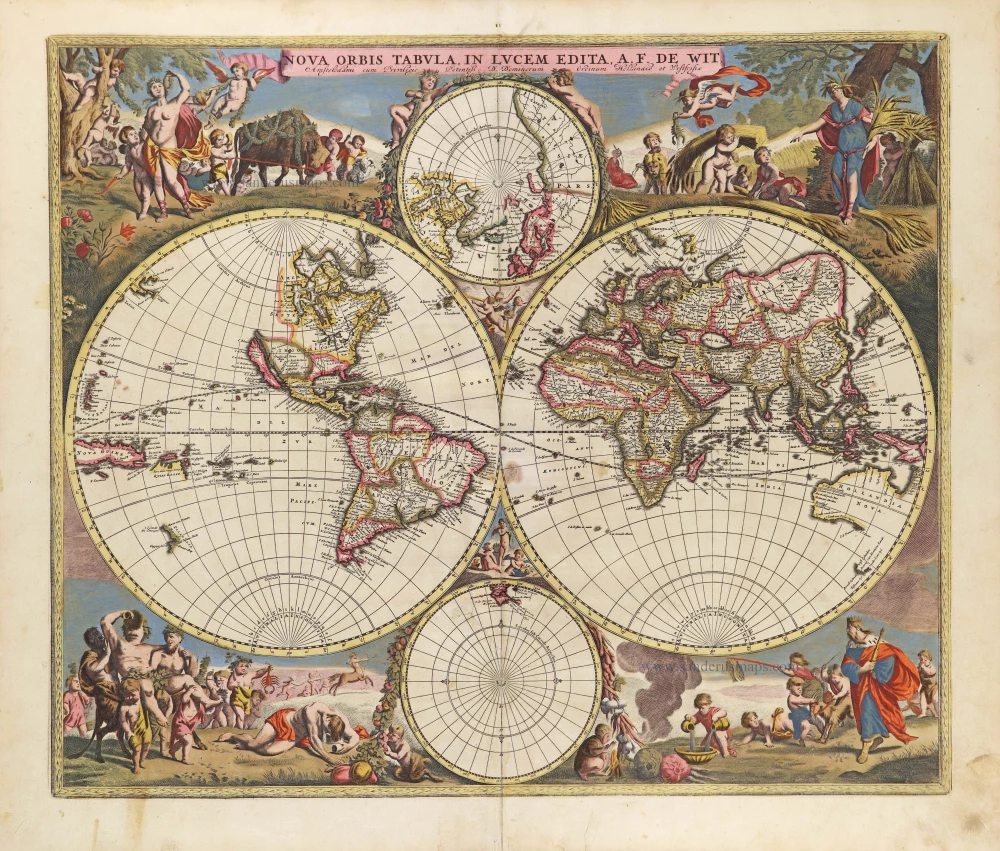
Nova Orbis Tabula in Lucem Edita, A. F. De Wit. c. 1690
World by Frederik De Wit, double hemisphere.
[Item number: 29231]
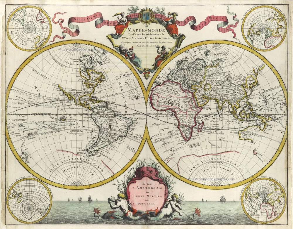
Mappe-Monde Dreßé sur les Observations de Mrs. de l'Academie Royale des Sciences et quelques autres et sur les memoires les plus recens. 1705-1711
World in two hemispheres by Pieter Mortier.
[Item number: 29509]

Mapmonde ou description generale du Globe Terrestre. 1713
World map by Zacharias Châtelain.
[Item number: 29555]
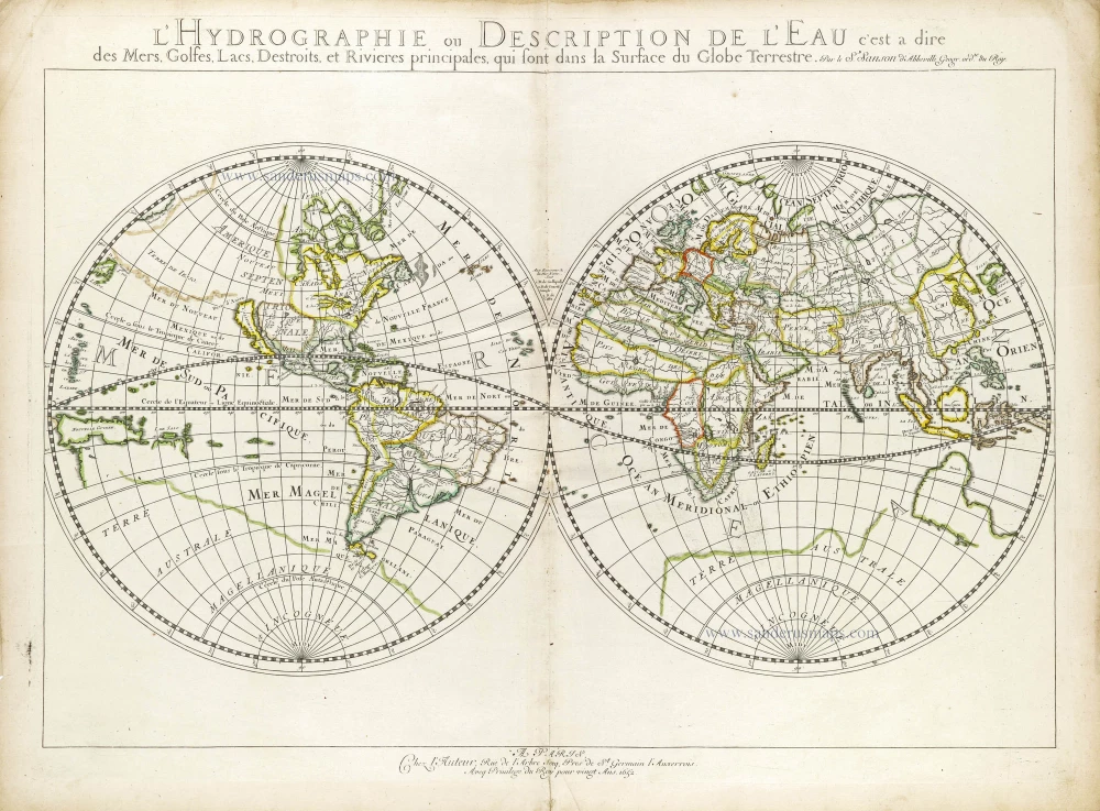
L'Hydrographie ou Description de l'Eau c'est a Dire des Mers, Golfes, Lacs, Destroits et Rivieres Principales qui sont dans la Surface du Globe Terrestre. 1652
World map, double-hemisphere by Nicolas Sanson.
[Item number: 29606]
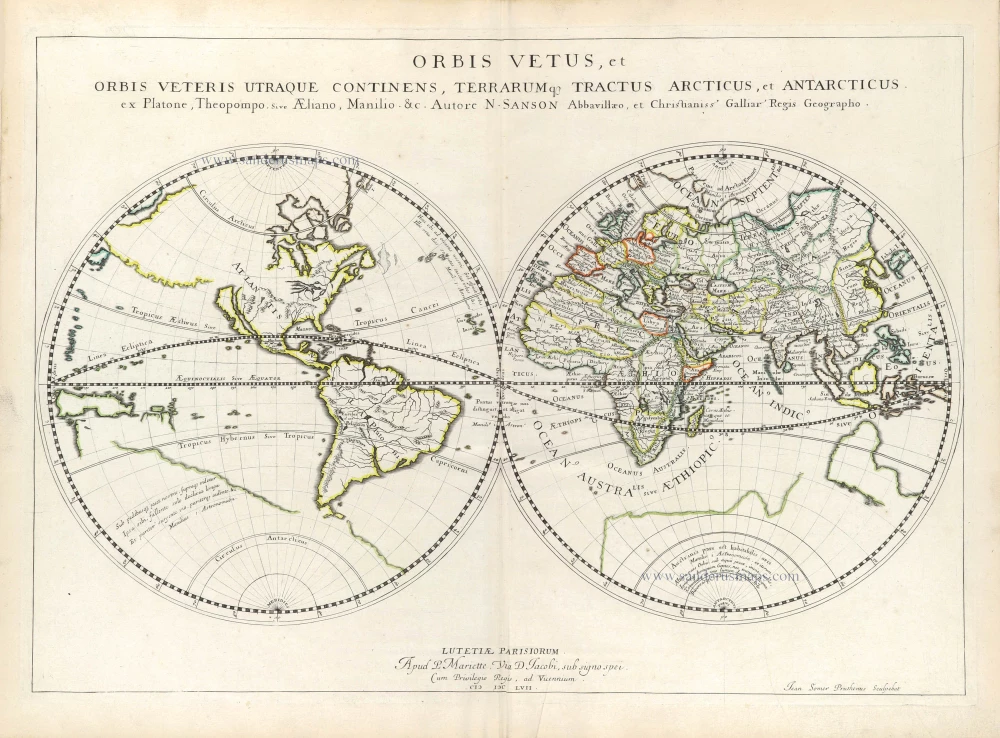
Orbis Vetus, et Orbis Veteris Ultraque continens, Terrarumq. Tractus Arcticus, et Antarcticus ex Platone, Theopompo, sive Aeliano, Manilio &c. 1658
Double hemisphere map of the Ancient World by Nicolas Sanson.
[Item number: 29609]

Mappe-Monde, ou Carte Generale du Monde, 1652
Double hemisphere world map by Nicolas Sanson.
[Item number: 29612]
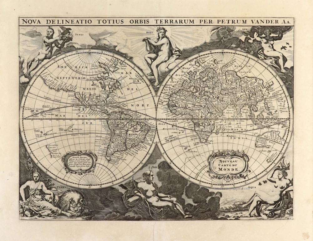
Nova Delineatio Totius Orbis Terrarum per Petrum Van der Aa. - Nouveau Carte du Monde. 1702
World by Pieter Van der Aa - double hemisphere.
[Item number: 30150]

'One of the supreme examples of map maker's art' (Shirley)
Nova Totius Terrarum Orbis Geographica ac Hydrographica. 1643
World in Mercator projection, by Willem Blaeu.
[Item number: 30271]
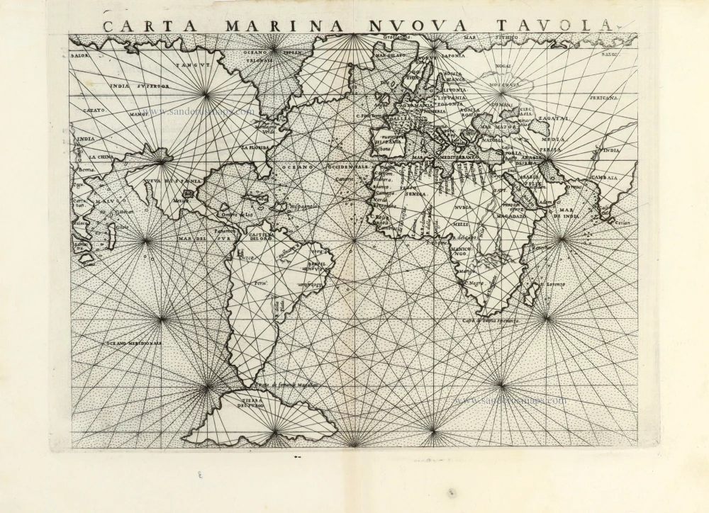
Carta Marina Nuova Tavola. 1561
World chart by Girolamo Ruscelli.
[Item number: 30380]
new