
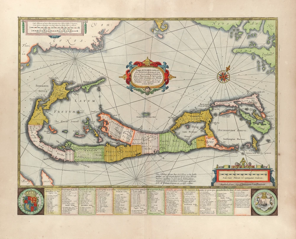
Bermuda by Henricus Hondius.
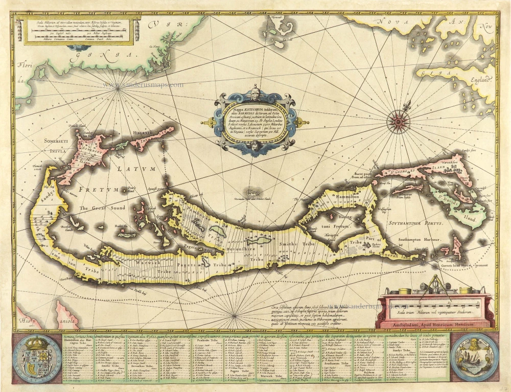
"The most striking and technically brilliant map of Bermuda in the 17th century" (Palmer)
Bermuda is believed to have been discovered by accident in 1505 by a Spaniard, Juan de Bermudez. However, because it was so small, the group of islands remained uninhabited until an English expedition of 1609. In 1615 the Bermuda Company was founded to invest and profit from the new colony, and Richard Norwood was sent to survey the islands, using a canoe to travel around. In 1617 he divided Bermuda into firstly large parishes and then 25-acre (10-hectare) strips of shares, to be sold to settlers, as depicted on the map.
His map of the island was published in 1622, but no surviving example is known today. However, a derivative appeared in Speed's world atlas, the Prospect of the Most Famous Parts of the World, and this is believed to be the source for several continental copies.
One of the most amusing cartographic mistakes developed from Norwood's map. To show the position of Bermuda concerning the mainland, the outline of North America is shown, with New England on the right and Florida on the left, with a small depiction of Bermuda just under the cartouche. Later cartographers, including Herman Moll, George Louis Le Rouge and Antonio Zatta copied the main map, leaving out the outline of North America but retaining the miniature version of Bermuda as different islands. The mistake could be explained by using two names for the islands, the 'Summer Islands' or 'Bermuda'. (Baynton-Williams)
The Hondius Family
Jodocus Hondius the Elder (1563-1612)
Joost d’Hondt was born at Wakken (Flanders) in 1563. Two years later, his family settled in Ghent, where young Joost displayed an excellent gift for drawing and calligraphy. Through study and lessons, he developed his talents and became an engraver with a good reputation.
Due to the circumstances of the war, he moved to London in 1584, where he settled down as an engraver, instrument-maker, and map-maker. In 1587, he married Coletta van den Keere, sister of the well-known engraver Pieter van den Keere (Petrus Kaerius); some years earlier, his sister, Jacomina, had married Pieter van den Berghe (Petrus Montanus). Joost, who had Latinized his name to Jodocus Hondius, closely co-operated with his two brothers-in-law.
The political situation in the Northern Netherlands in 1593 was such that Jodocus seemed justified in establishing himself in Amsterdam, where many Antwerp printers, publishers, and engravers had gone. In this new centre of cartography, Jodocus Hondius set up his business “In de Wackere Hondt” (in the vigilant dog), this name being an allusion to his birthplace and name. He engraved many maps and published atlases and many other works, such as his continuation of Gerard Mercator’s Atlas.
He suddenly passed away in February 1612. The publishing firm of Jodocus Hondius was continued by his widow, later on, by his two sons, Jodocus Jr. and Henricus, and by his son-in-law, J. Janssonius.
Jodocus Hondius II (1594-1629) & Henricus Hondius (1597-1651)
After the father’s death, the widow and her seven children continued publishing the atlases under the name of Jodocus Hondius till 1620. The firm was reinforced by the very welcome help of Joannes Janssonius (1588-1664), who married 24-year-old Elisabeth Hondius in 1612. After 1619, Mercator’s Atlas was published under the name of Henricus Hondius.
One of the most dramatic events in the early history of commercial cartography in Amsterdam was the sale of Jodocus Hondius Jr.’s copper plates to Willem Jansz. Blaeu in 1629, the year of his death. At least 34 plates, from which Jodocus II had printed single-sheet maps for his benefit, passed into the hands of his great competitor. Immediately after that, his brother, Henricus, and Joannes Janssonius ordered the engraving of identical plates.
Henricus devoted all his energy to publishing the Atlas for an extended period. He saw its growth up to and including the fourth part in 1646; after that, his name no longer figures on the title pages. After 1638, the title of the Atlas was changed to Atlas Novus; Joannes Janssonius mainly carried it on.
The competition with the Blaeu's dates from 1630. In 1630, Willem Janszoon (=Blaeu) first attacked with his Atlantis Appendix. In 1635, Blaeu completed his Theatrum Orbis Terrarum in two volumes with French, Latin, Dutch, and German texts, prompting Henricus Hondius to speed up the enlargement of his Atlas.
Mappa Aestivarum Insularum alias Barmudas dictarum, ...
Item Number: 28831 Authenticity Guarantee
Category: Antique maps > America > North America
Old, antique map of Bermuda by Henricus Hondius.
Title: Mappa Aestivarum Insularum alias Barmudas dictarum, ...
Amstelodami, Apud Henricum Hondium.
Oriented to the northwest.
Date: 1633-1641
Copper engraving, printed on paper.
Map size: 395 x 515mm (15.55 x 20.28 inches).
Sheet size: 415 x 535mm (16.34 x 21.06 inches).
Verso: Blank.
Condition: Original coloured, new margins, reinforcements at the back.
Condition Rating: C.
Rare edition without text on the back.
"The most striking and technically brilliant map of Bermuda in the 17th century" (Palmer)
Bermuda is believed to have been discovered by accident in 1505 by a Spaniard, Juan de Bermudez. However, because it was so small, the group of islands remained uninhabited until an English expedition of 1609. In 1615 the Bermuda Company was founded to invest and profit from the new colony, and Richard Norwood was sent to survey the islands, using a canoe to travel around. In 1617 he divided Bermuda into firstly large parishes and then 25-acre (10-hectare) strips of shares, to be sold to settlers, as depicted on the map.
His map of the island was published in 1622, but no surviving example is known today. However, a derivative appeared in Speed's world atlas, the Prospect of the Most Famous Parts of the World, and this is believed to be the source for several continental copies.
One of the most amusing cartographic mistakes developed from Norwood's map. To show the position of Bermuda concerning the mainland, the outline of North America is shown, with New England on the right and Florida on the left, with a small depiction of Bermuda just under the cartouche. Later cartographers, including Herman Moll, George Louis Le Rouge and Antonio Zatta copied the main map, leaving out the outline of North America but retaining the miniature version of Bermuda as different islands. The mistake could be explained by using two names for the islands, the 'Summer Islands' or 'Bermuda'. (Baynton-Williams)
The Hondius Family
Jodocus Hondius the Elder (1563-1612)
Joost d’Hondt was born at Wakken (Flanders) in 1563. Two years later, his family settled in Ghent, where young Joost displayed an excellent gift for drawing and calligraphy. Through study and lessons, he developed his talents and became an engraver with a good reputation.
Due to the circumstances of the war, he moved to London in 1584, where he settled down as an engraver, instrument-maker, and map-maker. In 1587, he married Coletta van den Keere, sister of the well-known engraver Pieter van den Keere (Petrus Kaerius); some years earlier, his sister, Jacomina, had married Pieter van den Berghe (Petrus Montanus). Joost, who had Latinized his name to Jodocus Hondius, closely co-operated with his two brothers-in-law.
The political situation in the Northern Netherlands in 1593 was such that Jodocus seemed justified in establishing himself in Amsterdam, where many Antwerp printers, publishers, and engravers had gone. In this new centre of cartography, Jodocus Hondius set up his business “In de Wackere Hondt” (in the vigilant dog), this name being an allusion to his birthplace and name. He engraved many maps and published atlases and many other works, such as his continuation of Gerard Mercator’s Atlas.
He suddenly passed away in February 1612. The publishing firm of Jodocus Hondius was continued by his widow, later on, by his two sons, Jodocus Jr. and Henricus, and by his son-in-law, J. Janssonius.
Jodocus Hondius II (1594-1629) & Henricus Hondius (1597-1651)
After the father’s death, the widow and her seven children continued publishing the atlases under the name of Jodocus Hondius till 1620. The firm was reinforced by the very welcome help of Joannes Janssonius (1588-1664), who married 24-year-old Elisabeth Hondius in 1612. After 1619, Mercator’s Atlas was published under the name of Henricus Hondius.
One of the most dramatic events in the early history of commercial cartography in Amsterdam was the sale of Jodocus Hondius Jr.’s copper plates to Willem Jansz. Blaeu in 1629, the year of his death. At least 34 plates, from which Jodocus II had printed single-sheet maps for his benefit, passed into the hands of his great competitor. Immediately after that, his brother, Henricus, and Joannes Janssonius ordered the engraving of identical plates.
Henricus devoted all his energy to publishing the Atlas for an extended period. He saw its growth up to and including the fourth part in 1646; after that, his name no longer figures on the title pages. After 1638, the title of the Atlas was changed to Atlas Novus; Joannes Janssonius mainly carried it on.
The competition with the Blaeu's dates from 1630. In 1630, Willem Janszoon (=Blaeu) first attacked with his Atlantis Appendix. In 1635, Blaeu completed his Theatrum Orbis Terrarum in two volumes with French, Latin, Dutch, and German texts, prompting Henricus Hondius to speed up the enlargement of his Atlas.
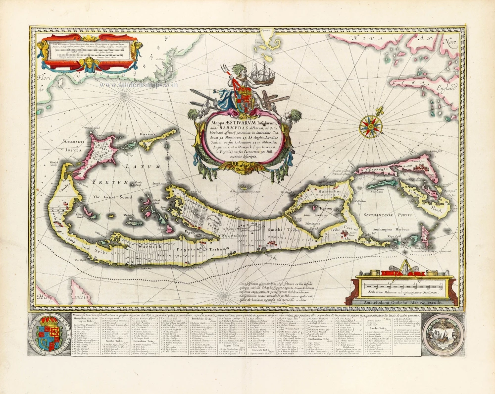
Related items
Mappa Aestivarum Insularum alias Barmudas dictarum, ... 1641
Bermuda, by Johannes Janssonius.
[Item number: 26460]
Mappa Aestivarum Insularum, alias Barmudas Dictarum ... Accurate Descripta. 1670
Bermuda, by John Ogilby.
[Item number: 27398]
Mappa Aestivarum Insularum alias Bermudas ... 1734
Bermuda, by Nicolas Sanson.
[Item number: 27841]
Mappa Aestivarum Insularum alias Barmudas dictarum, ... 1666
Bermuda by Joannes Janssonius.
[Item number: 29951]
The most striking and technically brilliant map of Bermuda in the 17th century
Mappa Aestivarum Insularum alias Barmudas dictarum, ad Ostia Mexicani aestuarij jacentium in Latitudine Graduum 32 Minutorum 25. ... accurate descripta. 1643
Bermuda by Willem Blaeu.
[Item number: 30007]