
Pápa in Hungary, by Georg Braun and Frans Hogenberg, after Georg Hoefnagel. 1618

Key to 10 locations.
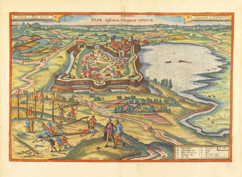
CAPTION: Pápa. Town in Lower Hungary.
CARTOUCHES: Received from Philipp Fernandus by Georg Hoefnagel, who passed it on.
COMMENTARY BY BRAUN (on verso): "This fortress was conquered by Emin Pasha in 1592, together with Sisak, Vesprém and Palota, through Christian treachery. Some garrisons defected to the Turks and showed them the fortress's weak points. Thus, the garrison could not hold the fortress well, and they gave it up without good cause. If they had been more courageous, they would have been able to hold out much longer. But they got their deserts. Although they had been promised they would be able to leave without any harm to person or property, they were surrounded by Turkish horsemen in the open countryside, and almost all were killed."
This plate portrays human cruelty in a manner that is rare in work by Braun and Hogenberg: in the left foreground is a depiction of the impaling of Christians by the Deli, a particular cavalry unit of the Ottomans, identifiable by their feather headdresses. In the background are the town and castle (A), seen from the south, surrounded on three sides by a moat and entirely enclosed by a rampart and palisade. The castle, visible in the middle at the top, stands on a hill and is protected by its rampart and moat on the town side. Mentioned for the first time in the 11th century, Pápa developed only slowly into a market town. In the 16th century, it was an important centre of the Protestant Reformation in western Hungary.
Braun G. & Hogenberg F. and the Civitates Orbis Terrarum.
The Civitates Orbis Terrarum, or the "Braun & Hogenberg", is a six-volume town atlas and the most excellent book of town views and plans ever published: 363 engravings, sometimes beautifully coloured. It was one of the best-selling works in the last quarter of the 16th century. Georg Braun wrote the text accompanying the plans and views on the verso. Many plates were engraved after the original drawings of a professional artist, a professional artist, Joris Hoefnagel (1542-1600). The first volume was published in Latin in 1572, and the sixth in 1617. Frans Hogenberg created the tables for volumes I through IV, and Simon van den Neuwel made those for volumes V and VI. Other contributors were cartographers Daniel Freese and Heinrich Rantzau. Works by Jacob van Deventer, Sebastian Münster, and Johannes Stumpf were also used. Translations appeared in German and French.
Following the original publication of Volume 1 of the Civitates in 1572, seven further editions of 1575, 1577, 1582, 1588, 1593, 1599 and 1612 can be identified. Vol.2, first issued in 1575, was followed by further editions in 1597 and 1612. The subsequent volumes appeared in 1581, 1588, 1593, 1599 and 1606. The German translation of the first volume appeared from 1574 on, and the French edition from 1575 on.
Several printers were involved: Theodor Graminaeus, Heinrich von Aich, Gottfried von Kempen, Johannis Sinniger, Bertram Buchholtz and Peter von Brachel, who all worked in Cologne.
Georg Braun (1541-1622)
Georg Braun was born in Cologne in 1541. After his studies in Cologne, he entered the Jesuit Order as a novice. 1561, he obtained his bachelor's degree, and in 1562, he received his Magister Artium. Although he left the Jesuit Order, he studied theology, gaining a licentiate in theology.
Frans Hogenberg (1535-1590)
Frans Hogenberg was a Flemish and German painter, engraver, and mapmaker. He was born in Mechelen as the son of Nicolaas Hogenberg.
By the end of the 1560s, Frans Hogenberg was employed upon Abraham Ortelius's Theatrum Orbis Terrarum, published in 1570; he is named an engraver of numerous maps. In 1568, he was banned from Antwerp by the Duke of Alva and travelled to London, where he stayed a few years before emigrating to Cologne. He immediately embarked on his two most important works, the Civitates, published in 1572 and the Geschichtsblätter, which appeared in several series from 1569 until about 1587.
Thanks to large-scale projects like the Geschichtsblätter and the Civitates, Hogenberg's social circumstances improved with each passing year. He died as a wealthy man in Cologne in 1590.
Papa, Inferioris Hungariae Oppidum.
Item Number: 28917 Authenticity Guarantee
Category: Antique maps > Europe > Central Europe
Old, antique bird’s-eye view plan of Pápa in Hungary, by Georg Braun and Frans Hogenberg, after Georg Hoefnagel.
Title: Papa, Inferioris Hungariae Oppidum.
Acceptum a Philippo Fernandeo:
Communicavit G. Houfnaglius.
A° 1617
Designer: Georg Hoefnagel.
Date of the first edition: 1617.
Date of this map: 1618.
Date on map: 1617
Copper engraving, printed on paper.
Map size: 335 x 490mm (13.19 x 19.29 inches).
Sheet size: 415 x 535mm (16.34 x 21.06 inches).
Verso: Latin text.
Condition: Hand coloured, excellent.
Condition Rating: A+.
From: Theatri praecipuarum Totius Mundi Urbium Liber Sextus Anno MDCXVIII. (Van der Krogt 4, 41:1.6)
Key to 10 locations.
CAPTION: Pápa. Town in Lower Hungary.
CARTOUCHES: Received from Philipp Fernandus by Georg Hoefnagel, who passed it on.
COMMENTARY BY BRAUN (on verso): "This fortress was conquered by Emin Pasha in 1592, together with Sisak, Vesprém and Palota, through Christian treachery. Some garrisons defected to the Turks and showed them the fortress's weak points. Thus, the garrison could not hold the fortress well, and they gave it up without good cause. If they had been more courageous, they would have been able to hold out much longer. But they got their deserts. Although they had been promised they would be able to leave without any harm to person or property, they were surrounded by Turkish horsemen in the open countryside, and almost all were killed."
This plate portrays human cruelty in a manner that is rare in work by Braun and Hogenberg: in the left foreground is a depiction of the impaling of Christians by the Deli, a particular cavalry unit of the Ottomans, identifiable by their feather headdresses. In the background are the town and castle (A), seen from the south, surrounded on three sides by a moat and entirely enclosed by a rampart and palisade. The castle, visible in the middle at the top, stands on a hill and is protected by its rampart and moat on the town side. Mentioned for the first time in the 11th century, Pápa developed only slowly into a market town. In the 16th century, it was an important centre of the Protestant Reformation in western Hungary.
Braun G. & Hogenberg F. and the Civitates Orbis Terrarum.
The Civitates Orbis Terrarum, or the "Braun & Hogenberg", is a six-volume town atlas and the most excellent book of town views and plans ever published: 363 engravings, sometimes beautifully coloured. It was one of the best-selling works in the last quarter of the 16th century. Georg Braun wrote the text accompanying the plans and views on the verso. Many plates were engraved after the original drawings of a professional artist, a professional artist, Joris Hoefnagel (1542-1600). The first volume was published in Latin in 1572, and the sixth in 1617. Frans Hogenberg created the tables for volumes I through IV, and Simon van den Neuwel made those for volumes V and VI. Other contributors were cartographers Daniel Freese and Heinrich Rantzau. Works by Jacob van Deventer, Sebastian Münster, and Johannes Stumpf were also used. Translations appeared in German and French.
Following the original publication of Volume 1 of the Civitates in 1572, seven further editions of 1575, 1577, 1582, 1588, 1593, 1599 and 1612 can be identified. Vol.2, first issued in 1575, was followed by further editions in 1597 and 1612. The subsequent volumes appeared in 1581, 1588, 1593, 1599 and 1606. The German translation of the first volume appeared from 1574 on, and the French edition from 1575 on.
Several printers were involved: Theodor Graminaeus, Heinrich von Aich, Gottfried von Kempen, Johannis Sinniger, Bertram Buchholtz and Peter von Brachel, who all worked in Cologne.
Georg Braun (1541-1622)
Georg Braun was born in Cologne in 1541. After his studies in Cologne, he entered the Jesuit Order as a novice. 1561, he obtained his bachelor's degree, and in 1562, he received his Magister Artium. Although he left the Jesuit Order, he studied theology, gaining a licentiate in theology.
Frans Hogenberg (1535-1590)
Frans Hogenberg was a Flemish and German painter, engraver, and mapmaker. He was born in Mechelen as the son of Nicolaas Hogenberg.
By the end of the 1560s, Frans Hogenberg was employed upon Abraham Ortelius's Theatrum Orbis Terrarum, published in 1570; he is named an engraver of numerous maps. In 1568, he was banned from Antwerp by the Duke of Alva and travelled to London, where he stayed a few years before emigrating to Cologne. He immediately embarked on his two most important works, the Civitates, published in 1572 and the Geschichtsblätter, which appeared in several series from 1569 until about 1587.
Thanks to large-scale projects like the Geschichtsblätter and the Civitates, Hogenberg's social circumstances improved with each passing year. He died as a wealthy man in Cologne in 1590.
Related items
Cassovia superioris Hungariae civitas primaria. c. 1625
Kosice (Hungary) by Georg Braun & Frans Hogenberg.
[Item number: 16448]

Very rare
Hungaria Regnum. 16th cent.
Hungary by an unknown mapmaker.
[Item number: 24501]
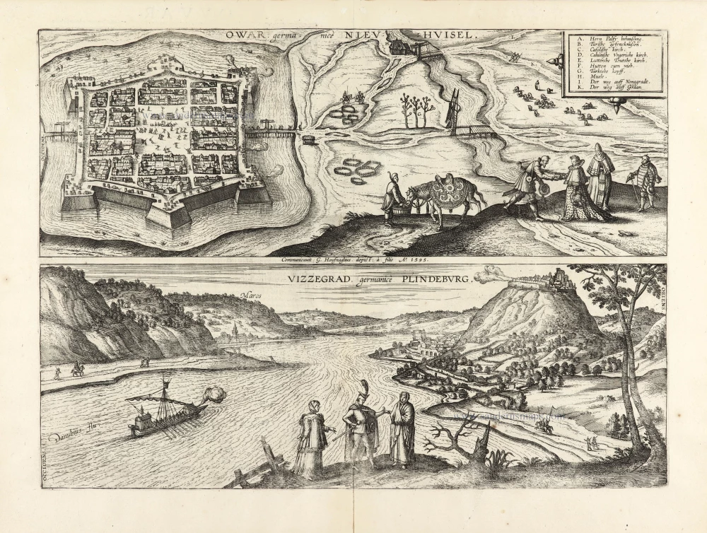
Owar Germanice Nieuhuisel [on sheet with] Vizzegrad, Germanice Plindeburg. 1617
Nové Zámky - Visegrád, by Georg Braun and Frans Hogenberg.
[Item number: 30112]