
Bratislava by Georg Braun & Frans Hogenberg. 1588
The item displayed on this page has been sold. However, we have a similar map in stock:
Bratislava by Georg Braun & Frans Hogenberg. 1612
Pressburg - Posonium vel Pisonium vt Lazius ...
[Item number: 29801]

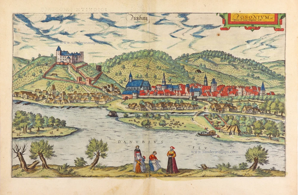


CARTOUCHE: Posonium, also called Pressburg, Hungarian city.
COMMENTARY BY BRAUN (on verso): "This is an old and beautiful city far superior to any other city in Austria, not only in its fortunate situation but also because of the way of life there and the bracing climate. The city is surrounded by hills covered with vineyards and many forests. That is why the sun does not allow the wine here to become too sweet. Near the outskirts, there is a castle on a high hill, which defends the city from its enemies and ensures that it continues in due obeisance to and venerates its lawful rulers. Below it flows the famous River Danube, through verdant meadows, gardens and paddock, in which flocks of sheep, chamois, deer and other game are seen to disport themselves."
This is a view from a highly raised vantage point looking from the south across to the city on the north bank of the Danube, with the Little Carpathians rising in the background. On the left is the castle on a hill with the city fringing its foot. St Martin's cathedral, its tower represented on a disproportionately small scale, is on the western fringes of the moderately fortified city. Bratislava (German Pressburg) almost continuously belonged to the Kingdom of Hungary from the early 10th century until 1918. A market town grew below an old castle and numerous German colonists settled here in 1241. After much of Hungary's territory and capital, Buda (Ofen), fell to the Ottoman Empire in 1526, Bratislava was used as the capital into the 18th century. The Hungarian Habsburgs were crowned in St Martin's between 1563 and 1830. In 1918 Bratislava was ceded to the new Republic of Czechoslovakia; since 1993, it has been the capital of Slovakia. (Taschen)
Braun G. & Hogenberg F. and the Civitates Orbis Terrarum.
The Civitates Orbis Terrarum, or the "Braun & Hogenberg", is a six-volume town atlas and the most excellent book of town views and plans ever published: 363 engravings, sometimes beautifully coloured. It was one of the best-selling works in the last quarter of the 16th century. Georg Braun wrote the text accompanying the plans and views on the verso. Many plates were engraved after the original drawings of a professional artist, a professional artist, Joris Hoefnagel (1542-1600). The first volume was published in Latin in 1572, and the sixth in 1617. Frans Hogenberg created the tables for volumes I through IV, and Simon van den Neuwel made those for volumes V and VI. Other contributors were cartographers Daniel Freese and Heinrich Rantzau. Works by Jacob van Deventer, Sebastian Münster, and Johannes Stumpf were also used. Translations appeared in German and French.
Following the original publication of Volume 1 of the Civitates in 1572, seven further editions of 1575, 1577, 1582, 1588, 1593, 1599 and 1612 can be identified. Vol.2, first issued in 1575, was followed by further editions in 1597 and 1612. The subsequent volumes appeared in 1581, 1588, 1593, 1599 and 1606. The German translation of the first volume appeared from 1574 on, and the French edition from 1575 on.
Several printers were involved: Theodor Graminaeus, Heinrich von Aich, Gottfried von Kempen, Johannis Sinniger, Bertram Buchholtz and Peter von Brachel, who all worked in Cologne.
Georg Braun (1541-1622)
Georg Braun was born in Cologne in 1541. After his studies in Cologne, he entered the Jesuit Order as a novice. 1561, he obtained his bachelor's degree, and in 1562, he received his Magister Artium. Although he left the Jesuit Order, he studied theology, gaining a licentiate in theology.
Frans Hogenberg (1535-1590)
Frans Hogenberg was a Flemish and German painter, engraver, and mapmaker. He was born in Mechelen as the son of Nicolaas Hogenberg.
By the end of the 1560s, Frans Hogenberg was employed upon Abraham Ortelius's Theatrum Orbis Terrarum, published in 1570; he is named an engraver of numerous maps. In 1568, he was banned from Antwerp by the Duke of Alva and travelled to London, where he stayed a few years before emigrating to Cologne. He immediately embarked on his two most important works, the Civitates, published in 1572 and the Geschichtsblätter, which appeared in several series from 1569 until about 1587.
Thanks to large-scale projects like the Geschichtsblätter and the Civitates, Hogenberg's social circumstances improved with each passing year. He died as a wealthy man in Cologne in 1590.
Pressburg - Posonium vel Pisonium vt Lazius Hungariae urbs.
Item Number: 28960 Authenticity Guarantee
Category: Antique maps > Europe > Central Europe
Antique map - Bird's-eye view of Bratislava (Presburg - Pozsony) by Georg Braun & Frans Hogenberg.
Title: Pressburg - Posonium vel Pisonium vt Lazius Hungariae urbs.
Date of the first edition: 1588.
Date of this map: 1588.
Copper engraving, printed on paper.
Map size: 290 x 490mm (11.42 x 19.29 inches).
Sheet size: 395 x 535mm (15.55 x 21.06 inches).
Verso: Latin text.
Condition: Original coloured, excellent.
Condition Rating: A+.
From: Liber Quartus Urbium Praecipuarum Totius Mundi. Cologne, 1588. (Koeman, B&H4, Van der Krogt 4, 41:1.4)
CARTOUCHE: Posonium, also called Pressburg, Hungarian city.
COMMENTARY BY BRAUN (on verso): "This is an old and beautiful city far superior to any other city in Austria, not only in its fortunate situation but also because of the way of life there and the bracing climate. The city is surrounded by hills covered with vineyards and many forests. That is why the sun does not allow the wine here to become too sweet. Near the outskirts, there is a castle on a high hill, which defends the city from its enemies and ensures that it continues in due obeisance to and venerates its lawful rulers. Below it flows the famous River Danube, through verdant meadows, gardens and paddock, in which flocks of sheep, chamois, deer and other game are seen to disport themselves."
This is a view from a highly raised vantage point looking from the south across to the city on the north bank of the Danube, with the Little Carpathians rising in the background. On the left is the castle on a hill with the city fringing its foot. St Martin's cathedral, its tower represented on a disproportionately small scale, is on the western fringes of the moderately fortified city. Bratislava (German Pressburg) almost continuously belonged to the Kingdom of Hungary from the early 10th century until 1918. A market town grew below an old castle and numerous German colonists settled here in 1241. After much of Hungary's territory and capital, Buda (Ofen), fell to the Ottoman Empire in 1526, Bratislava was used as the capital into the 18th century. The Hungarian Habsburgs were crowned in St Martin's between 1563 and 1830. In 1918 Bratislava was ceded to the new Republic of Czechoslovakia; since 1993, it has been the capital of Slovakia. (Taschen)
Braun G. & Hogenberg F. and the Civitates Orbis Terrarum.
The Civitates Orbis Terrarum, or the "Braun & Hogenberg", is a six-volume town atlas and the most excellent book of town views and plans ever published: 363 engravings, sometimes beautifully coloured. It was one of the best-selling works in the last quarter of the 16th century. Georg Braun wrote the text accompanying the plans and views on the verso. Many plates were engraved after the original drawings of a professional artist, a professional artist, Joris Hoefnagel (1542-1600). The first volume was published in Latin in 1572, and the sixth in 1617. Frans Hogenberg created the tables for volumes I through IV, and Simon van den Neuwel made those for volumes V and VI. Other contributors were cartographers Daniel Freese and Heinrich Rantzau. Works by Jacob van Deventer, Sebastian Münster, and Johannes Stumpf were also used. Translations appeared in German and French.
Following the original publication of Volume 1 of the Civitates in 1572, seven further editions of 1575, 1577, 1582, 1588, 1593, 1599 and 1612 can be identified. Vol.2, first issued in 1575, was followed by further editions in 1597 and 1612. The subsequent volumes appeared in 1581, 1588, 1593, 1599 and 1606. The German translation of the first volume appeared from 1574 on, and the French edition from 1575 on.
Several printers were involved: Theodor Graminaeus, Heinrich von Aich, Gottfried von Kempen, Johannis Sinniger, Bertram Buchholtz and Peter von Brachel, who all worked in Cologne.
Georg Braun (1541-1622)
Georg Braun was born in Cologne in 1541. After his studies in Cologne, he entered the Jesuit Order as a novice. 1561, he obtained his bachelor's degree, and in 1562, he received his Magister Artium. Although he left the Jesuit Order, he studied theology, gaining a licentiate in theology.
Frans Hogenberg (1535-1590)
Frans Hogenberg was a Flemish and German painter, engraver, and mapmaker. He was born in Mechelen as the son of Nicolaas Hogenberg.
By the end of the 1560s, Frans Hogenberg was employed upon Abraham Ortelius's Theatrum Orbis Terrarum, published in 1570; he is named an engraver of numerous maps. In 1568, he was banned from Antwerp by the Duke of Alva and travelled to London, where he stayed a few years before emigrating to Cologne. He immediately embarked on his two most important works, the Civitates, published in 1572 and the Geschichtsblätter, which appeared in several series from 1569 until about 1587.
Thanks to large-scale projects like the Geschichtsblätter and the Civitates, Hogenberg's social circumstances improved with each passing year. He died as a wealthy man in Cologne in 1590.