Sea chart of Europe, by Frederick de Wit. c. 1705
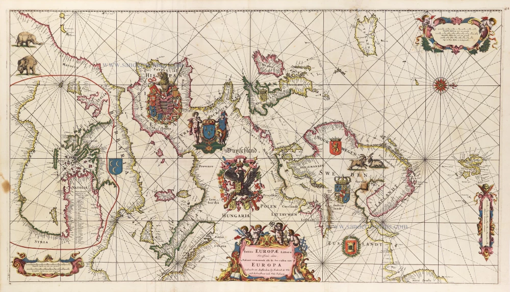


"The most striking and decorative map in de Wit's Orbis Maritimus." (Ginsberg). Aside from its multitude of decorative elements, de Wit has charted the eastern half of the Mediterranean in the area otherwise occupied by North Africa.
Frederick de Wit (1630-1706)
The engraver and map-seller, Frederick de Wit, was born in Gouda (Netherlands) in 1630 as a son of Hendrick Fredericksz de Wit. Through his marriage with Maria van der Waag of Amsterdam in 1661, he obtained citizenship of the city where he had been working since 1648 and where he became one of the most famous engravers of maps of the second half of the 17th century. Although De Wit was a Catholic, which meant that he was not favoured at the time by the city council, he was awarded the honour of being listed as one of the "excellent citizens" on the roll of the city council in the years 1694-1704. However, his name was not written in the Guild of St. Luke book before 1664. At that time, he lived on the Kalverstraat "in de Witte Pascaert", where he stayed until his death in 1706. His earliest dates on maps engraved are 1659 (Regni Daniae) and 1660 (World map).
Frederick de Wit published several world atlases, a sea atlas, and an atlas of the Netherlands.
The dating of the maps is difficult. However, as a privilege was granted in 1689, the annotation 'cum privilegio' marks an edition after 1688.
Around 1700, Frederick de Wit entered the market with a town atlas. He produced two volumes with a total of 260 plans and views. Most were printed from plates used for Janssonius and Blaeu town atlases.
After he died in 1706, his widow continued the shop until 1709. The plates and stock of De Wit's atlas were sold to Covens & Mortier in 1710, who sold the atlas for an extended period.
Totius Europae Littora Novissime Edita. Pascaert Vertoonende Alle de See-Custen van Europa.
Item Number: 29154 Authenticity Guarantee
Category: Antique maps > Europe > Europe Continent
Old, antique sea chart of Europe, by Frederick de Wit.
Title: Totius Europae Littora Novissime Edita. Pascaert Vertoonende Alle de See-Custen van Europa.
Gedruckt tot Amsterdam by Frederick de Wit inde Kalverstraet inde Witte Pascaert.
Oriented to the west.
Second State.
Date of the first edition: 1675.
Date of the first edition of the second state: ca. 1689-90.
Date of this map: ca. 1705.
Copper engraving, printed on paper from two plates, joined.
Map size: 490 x 880mm (19.29 x 34.65 inches).
Sheet size: 535 x 920mm (21.06 x 36.22 inches).
Verso: Blank.
Condition: Original coloured, reinforcements at the back.
Condition Rating: B+
From: Atlas. Amsterdam, Frederick de Wit, after 1705. (Koeman, III p. 202, Wit16; Carhart p. 159 A157)
Large coats of arms of Spain, France, and the German Empire. Inset map of the eastern part of the Mediterranean Sea, drawn in northern Africa.
"The most striking and decorative map in de Wit's Orbis Maritimus." (Ginsberg). Aside from its multitude of decorative elements, de Wit has charted the eastern half of the Mediterranean in the area otherwise occupied by North Africa.
Frederick de Wit (1630-1706)
The engraver and map-seller, Frederick de Wit, was born in Gouda (Netherlands) in 1630 as a son of Hendrick Fredericksz de Wit. Through his marriage with Maria van der Waag of Amsterdam in 1661, he obtained citizenship of the city where he had been working since 1648 and where he became one of the most famous engravers of maps of the second half of the 17th century. Although De Wit was a Catholic, which meant that he was not favoured at the time by the city council, he was awarded the honour of being listed as one of the "excellent citizens" on the roll of the city council in the years 1694-1704. However, his name was not written in the Guild of St. Luke book before 1664. At that time, he lived on the Kalverstraat "in de Witte Pascaert", where he stayed until his death in 1706. His earliest dates on maps engraved are 1659 (Regni Daniae) and 1660 (World map).
Frederick de Wit published several world atlases, a sea atlas, and an atlas of the Netherlands.
The dating of the maps is difficult. However, as a privilege was granted in 1689, the annotation 'cum privilegio' marks an edition after 1688.
Around 1700, Frederick de Wit entered the market with a town atlas. He produced two volumes with a total of 260 plans and views. Most were printed from plates used for Janssonius and Blaeu town atlases.
After he died in 1706, his widow continued the shop until 1709. The plates and stock of De Wit's atlas were sold to Covens & Mortier in 1710, who sold the atlas for an extended period.