
Cambridge, by Georg Braun and Frans Hogenberg. 1582
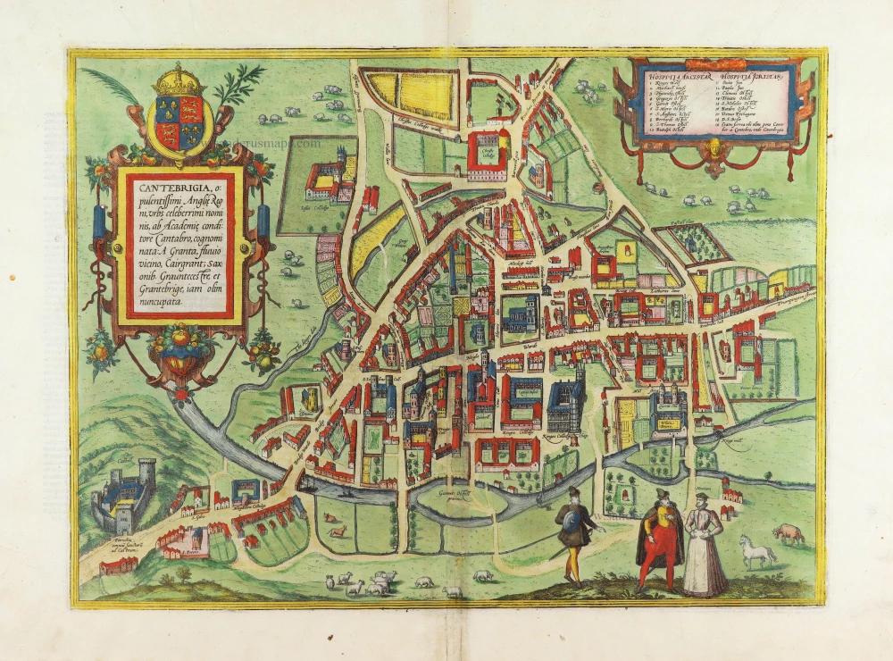


In the Latin text in the cartouche, Cambridge is confused with Canterbury.
COMMENTARY BY BRAUN (on verso): "Up to the present day, Cambridge has 19 student houses, in addition to which 14 colleges have been built with such grandeur and magnificence that you might think they were royal palaces and not accommodation for students. In short, although I have travelled in many countries and seen many cities, I must admit that I have hardly ever seen anything comparable to this town and these schools, for everything is in such perfect order that nothing better could be imagined."
The engraving shows Cambridge from a birds-eye perspective. In 1209 professors and students from Oxford founded the University of Cambridge. In 1284 Hugh de Balsham, bishop of Ely, founded the first College, Peterhouse, visible on the far right of the engraving. Near the River Cam is one of the best-known colleges in the city. King Henry VI founded King's College in 1441. King's College Chapel, completed in 1515, is an important example of Gothic architecture and one of the city's chief landmarks. The castle is seen from a low perspective in the lower lefthand corner. The Normans built it in 1068, two years after the coronation of William I as king of England. It was demolished in the 19th century to provide building materials for new colleges. (Taschen)
Braun G. & Hogenberg F. and the Civitates Orbis Terrarum.
The Civitates Orbis Terrarum, or the "Braun & Hogenberg", is a six-volume town atlas and the most excellent book of town views and plans ever published: 363 engravings, sometimes beautifully coloured. It was one of the best-selling works in the last quarter of the 16th century. Georg Braun wrote the text accompanying the plans and views on the verso. Many plates were engraved after the original drawings of a professional artist, a professional artist, Joris Hoefnagel (1542-1600). The first volume was published in Latin in 1572, and the sixth in 1617. Frans Hogenberg created the tables for volumes I through IV, and Simon van den Neuwel made those for volumes V and VI. Other contributors were cartographers Daniel Freese and Heinrich Rantzau. Works by Jacob van Deventer, Sebastian Münster, and Johannes Stumpf were also used. Translations appeared in German and French.
Following the original publication of Volume 1 of the Civitates in 1572, seven further editions of 1575, 1577, 1582, 1588, 1593, 1599 and 1612 can be identified. Vol.2, first issued in 1575, was followed by further editions in 1597 and 1612. The subsequent volumes appeared in 1581, 1588, 1593, 1599 and 1606. The German translation of the first volume appeared from 1574 on, and the French edition from 1575 on.
Several printers were involved: Theodor Graminaeus, Heinrich von Aich, Gottfried von Kempen, Johannis Sinniger, Bertram Buchholtz and Peter von Brachel, who all worked in Cologne.
Georg Braun (1541-1622)
Georg Braun was born in Cologne in 1541. After his studies in Cologne, he entered the Jesuit Order as a novice. 1561, he obtained his bachelor's degree, and in 1562, he received his Magister Artium. Although he left the Jesuit Order, he studied theology, gaining a licentiate in theology.
Frans Hogenberg (1535-1590)
Frans Hogenberg was a Flemish and German painter, engraver, and mapmaker. He was born in Mechelen as the son of Nicolaas Hogenberg.
By the end of the 1560s, Frans Hogenberg was employed upon Abraham Ortelius's Theatrum Orbis Terrarum, published in 1570; he is named an engraver of numerous maps. In 1568, he was banned from Antwerp by the Duke of Alva and travelled to London, where he stayed a few years before emigrating to Cologne. He immediately embarked on his two most important works, the Civitates, published in 1572 and the Geschichtsblätter, which appeared in several series from 1569 until about 1587.
Thanks to large-scale projects like the Geschichtsblätter and the Civitates, Hogenberg's social circumstances improved with each passing year. He died as a wealthy man in Cologne in 1590.
Cantebrigia, Opulentissimi Angliae Regni, urbs celeberrimi nominis, ...
Item Number: 29173 Authenticity Guarantee
Category: Antique maps > Europe > British Isles - Cities
Old, antique bird’s-eye view plan of Cambridge, by Georg Braun and Frans Hogenberg.
Title: Cantebrigia, Opulentissimi Angliae Regni, urbs celeberrimi nominis, ...
Engraved by Richard Lyne after a drawing by William Smith.
Date of this map: 1582.
Copper engraving, printed on paper.
Map size: 330 x 445mm (12.99 x 17.52 inches).
Sheet size: 395 x 530mm (15.55 x 20.87 inches).
Verso: Latin text.
Condition: Original coloured, excellent.
Condition Rating: A+.
From: Civitates Orbis Terrarum, Liber Secundus. Köln, Gottfried von Kempen, 1582. (Van der Krogt 4, 41:1.2)
In the Latin text in the cartouche, Cambridge is confused with Canterbury.
COMMENTARY BY BRAUN (on verso): "Up to the present day, Cambridge has 19 student houses, in addition to which 14 colleges have been built with such grandeur and magnificence that you might think they were royal palaces and not accommodation for students. In short, although I have travelled in many countries and seen many cities, I must admit that I have hardly ever seen anything comparable to this town and these schools, for everything is in such perfect order that nothing better could be imagined."
The engraving shows Cambridge from a birds-eye perspective. In 1209 professors and students from Oxford founded the University of Cambridge. In 1284 Hugh de Balsham, bishop of Ely, founded the first College, Peterhouse, visible on the far right of the engraving. Near the River Cam is one of the best-known colleges in the city. King Henry VI founded King's College in 1441. King's College Chapel, completed in 1515, is an important example of Gothic architecture and one of the city's chief landmarks. The castle is seen from a low perspective in the lower lefthand corner. The Normans built it in 1068, two years after the coronation of William I as king of England. It was demolished in the 19th century to provide building materials for new colleges. (Taschen)
Braun G. & Hogenberg F. and the Civitates Orbis Terrarum.
The Civitates Orbis Terrarum, or the "Braun & Hogenberg", is a six-volume town atlas and the most excellent book of town views and plans ever published: 363 engravings, sometimes beautifully coloured. It was one of the best-selling works in the last quarter of the 16th century. Georg Braun wrote the text accompanying the plans and views on the verso. Many plates were engraved after the original drawings of a professional artist, a professional artist, Joris Hoefnagel (1542-1600). The first volume was published in Latin in 1572, and the sixth in 1617. Frans Hogenberg created the tables for volumes I through IV, and Simon van den Neuwel made those for volumes V and VI. Other contributors were cartographers Daniel Freese and Heinrich Rantzau. Works by Jacob van Deventer, Sebastian Münster, and Johannes Stumpf were also used. Translations appeared in German and French.
Following the original publication of Volume 1 of the Civitates in 1572, seven further editions of 1575, 1577, 1582, 1588, 1593, 1599 and 1612 can be identified. Vol.2, first issued in 1575, was followed by further editions in 1597 and 1612. The subsequent volumes appeared in 1581, 1588, 1593, 1599 and 1606. The German translation of the first volume appeared from 1574 on, and the French edition from 1575 on.
Several printers were involved: Theodor Graminaeus, Heinrich von Aich, Gottfried von Kempen, Johannis Sinniger, Bertram Buchholtz and Peter von Brachel, who all worked in Cologne.
Georg Braun (1541-1622)
Georg Braun was born in Cologne in 1541. After his studies in Cologne, he entered the Jesuit Order as a novice. 1561, he obtained his bachelor's degree, and in 1562, he received his Magister Artium. Although he left the Jesuit Order, he studied theology, gaining a licentiate in theology.
Frans Hogenberg (1535-1590)
Frans Hogenberg was a Flemish and German painter, engraver, and mapmaker. He was born in Mechelen as the son of Nicolaas Hogenberg.
By the end of the 1560s, Frans Hogenberg was employed upon Abraham Ortelius's Theatrum Orbis Terrarum, published in 1570; he is named an engraver of numerous maps. In 1568, he was banned from Antwerp by the Duke of Alva and travelled to London, where he stayed a few years before emigrating to Cologne. He immediately embarked on his two most important works, the Civitates, published in 1572 and the Geschichtsblätter, which appeared in several series from 1569 until about 1587.
Thanks to large-scale projects like the Geschichtsblätter and the Civitates, Hogenberg's social circumstances improved with each passing year. He died as a wealthy man in Cologne in 1590.