
Sea chart of Western Africa, by Johannes Van Keulen. 1681
The item displayed on this page has been sold. However, we have a similar map in stock:
The coasts of Senegal - Gambia by Johannes Van Keulen. 1697-1709
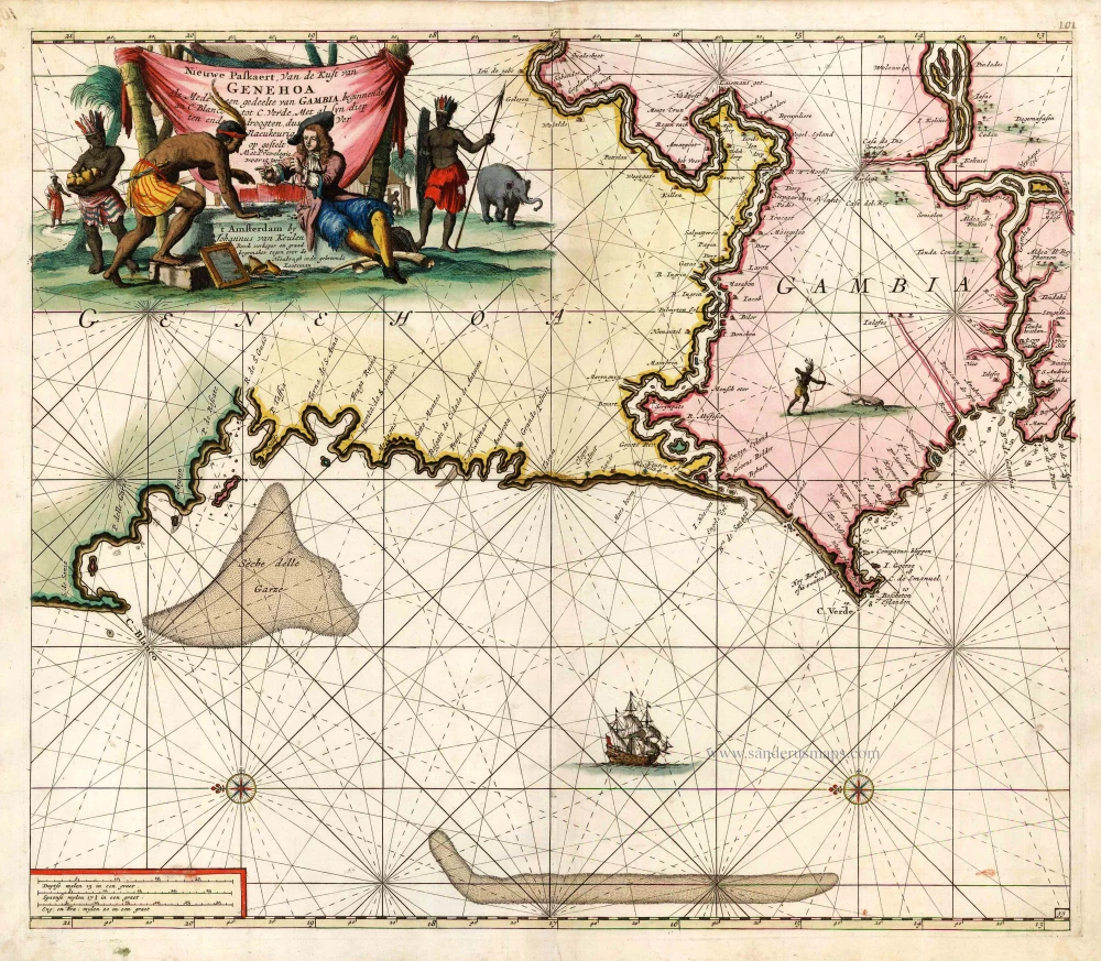
Nieuwe Paskaert, van de Kust van Genehoa als mede ...
[Item number: 2016]


The House of Van Keulen
For more than two centuries, the chart makers firm of Van Keulen was established in the house with the name of “De Gekroonde Lootsman” (The Crowned Pilot). In 1678, the founder of the firm, Johannes I Van Keulen (1634-1689), registered with the Amsterdam booksellers’ guild. He had enlisted the aid of the well-known Mathematical Practitioner Claas Janz Vooght in the preparation of his nautical publications. In 1680 he published the first edition of the Zee-Atlas with 40 charts, all issued for the first time. In the short period of four years, they produced the five volumes of the Nieuwe Groote Ligtende Zee-Fakkel (1681-85). His acquisition of the stock of the bookseller Hendrik Doncker was an essential factor in the development of the firm.
In 1678 a son, Gerard Van Keulen (1678-1726), was born out of Johannes’s first marriage. This son was endowed with talent. He was a skilful engraver and proficient in mathematics and navigational science. Gerard was responsible for establishing the scientific basis of the firm of Van Keulen. In 1714 he was appointed to the office of hydrographer to the Dutch East India Company. The Van Keulens remained chart makers to the East India Company until the Company’s liquidation.
With the introductions to the Zee-Fakkel and Zee-Atlas, Gerard van Keulen gave a new impetus to the firm. Unfortunately, he did not live long, dying when he was 49. The business was carried on by his widow Ludwina Konst. Shortly before Gerard’s death, his son Johannes II had entered the bookseller’s guild, and in 1726 he assumed the management of the firm, though his mother retained her financial interests in the business.
Johannes II Van Keulen (1704-1755) is known in particular for his publication in 1753 of a sixth volume of the Zee-Fakkel, the volume containing the charts of the route to the East Indies.
Johannes II had two sons; they joined the firm as partners in 1757. A considerable number of books appeared in the period 1778-1801. New issues of the Zee-Fakkel again saw the light. The firm flourished under different names until 1885.
Nieuwe Paskaert, van de Kust van Genehoa als mede een Gedeelte van Gambia, beginnende an C. Blanco tot C. Verde, Met al syn diep ten end droogten, dus Ver Naeukeurig op gestelt.
Item Number: 6636 Authenticity Guarantee
Category: Antique maps > Africa
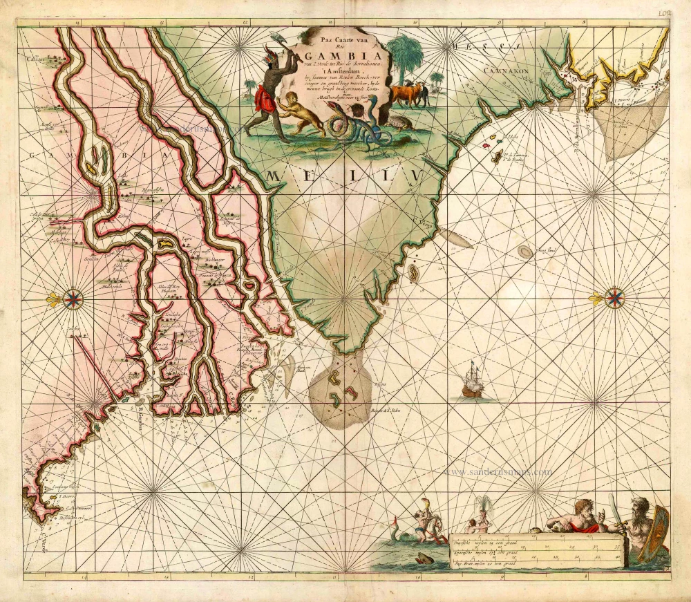
Old antique sea chart showing the coast of Western Africa, from Cabo Blanco till Cabo Verde (Dakar) and Gambia River, by J. Van Keulen.
Title: Nieuwe Paskaert, van de Kust van Genehoa als mede een Gedeelte van Gambia, beginnende an C. Blanco tot C. Verde, Met al syn diep ten end droogten, dus Ver Naeukeurig op gestelt.
Oriented to the east.
Date of the first edition: 1681.
Date of this map: 1681.
Copper engraving, printed on paper.
Size (not including margins): 500 x 570mm (19.69 x 22.44 inches).
Verso: Blank.
Condition: Original coloured, excellent.
Condition Rating: A+.
From: De Nieuwe Groote Lichtende Zee-Fackel, 't Tweede Deel. ... door Jan van Loon, en Claes Jansz. Vooght, ... Amsterdam, J. Van Keulen, 1681. (Koeman IV, Keu 57A).
The House of Van Keulen
For more than two centuries, the chart makers firm of Van Keulen was established in the house with the name of “De Gekroonde Lootsman” (The Crowned Pilot). In 1678, the founder of the firm, Johannes I Van Keulen (1634-1689), registered with the Amsterdam booksellers’ guild. He had enlisted the aid of the well-known Mathematical Practitioner Claas Janz Vooght in the preparation of his nautical publications. In 1680 he published the first edition of the Zee-Atlas with 40 charts, all issued for the first time. In the short period of four years, they produced the five volumes of the Nieuwe Groote Ligtende Zee-Fakkel (1681-85). His acquisition of the stock of the bookseller Hendrik Doncker was an essential factor in the development of the firm.
In 1678 a son, Gerard Van Keulen (1678-1726), was born out of Johannes’s first marriage. This son was endowed with talent. He was a skilful engraver and proficient in mathematics and navigational science. Gerard was responsible for establishing the scientific basis of the firm of Van Keulen. In 1714 he was appointed to the office of hydrographer to the Dutch East India Company. The Van Keulens remained chart makers to the East India Company until the Company’s liquidation.
With the introductions to the Zee-Fakkel and Zee-Atlas, Gerard van Keulen gave a new impetus to the firm. Unfortunately, he did not live long, dying when he was 49. The business was carried on by his widow Ludwina Konst. Shortly before Gerard’s death, his son Johannes II had entered the bookseller’s guild, and in 1726 he assumed the management of the firm, though his mother retained her financial interests in the business.
Johannes II Van Keulen (1704-1755) is known in particular for his publication in 1753 of a sixth volume of the Zee-Fakkel, the volume containing the charts of the route to the East Indies.
Johannes II had two sons; they joined the firm as partners in 1757. A considerable number of books appeared in the period 1778-1801. New issues of the Zee-Fakkel again saw the light. The firm flourished under different names until 1885.
Related items
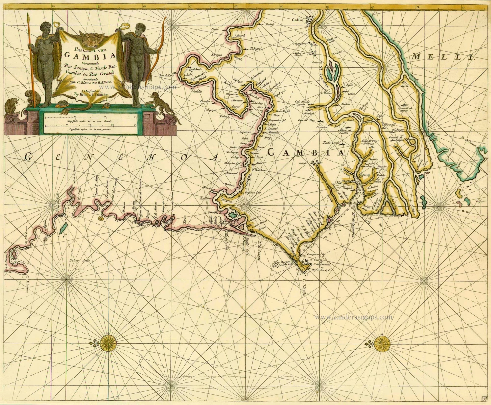
Pas Caart van GAMBIA Vertoonende Rio Senega, C. Verde, Rio Gambia en Rio Grande. Streckende van C. Blanco tot R. d'Nuna. 1686
Sea chart of the coasts of Senegal - Gambia, by Doncker H.
[Item number: 13653]
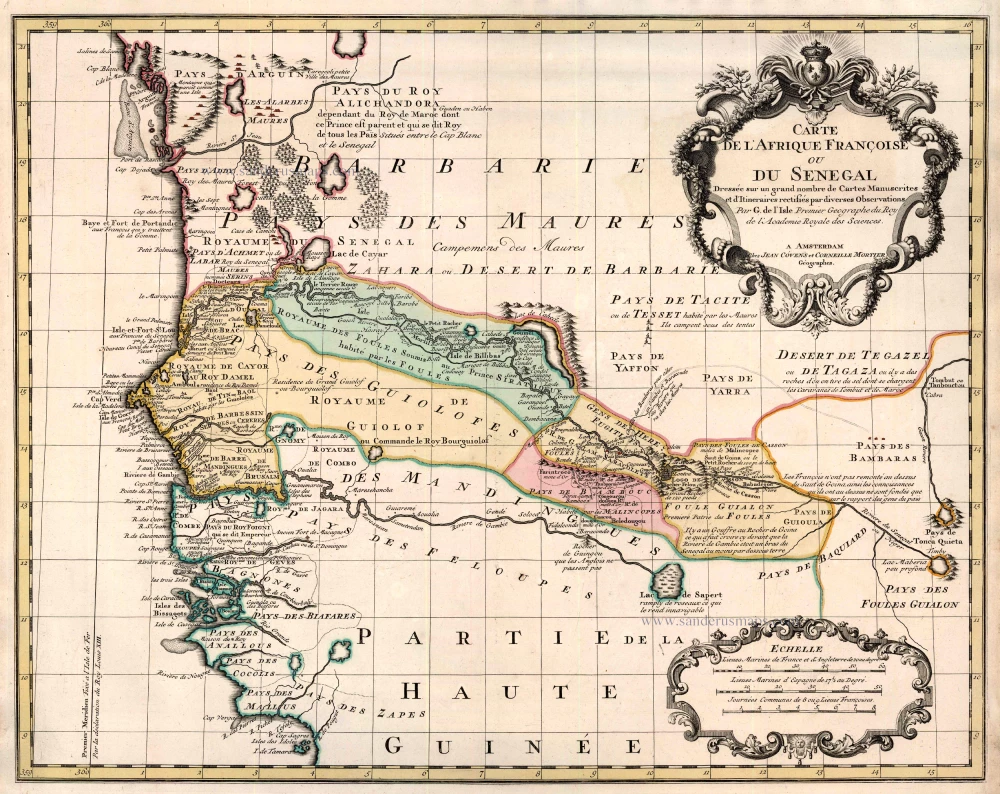
Carte de l'Afrique Françoise ou du Senegal ... 1721-41
Senegal by Guillaume Delisle, published by Covens & Mortier.
[Item number: 23614]
Pas Caarte van Rio Gambia van C. Verde tot Rio de Serraliones. 1683
Sea chart of Western Africa (The Gambia), by J. Van Keulen.
[Item number: 12768]