
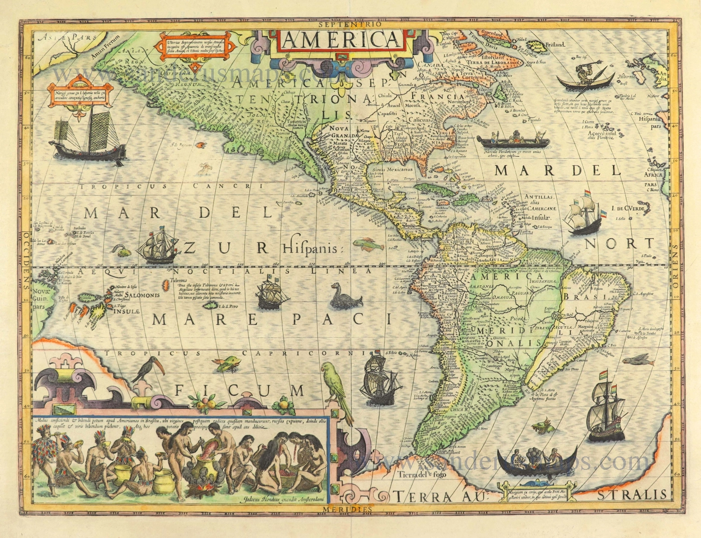
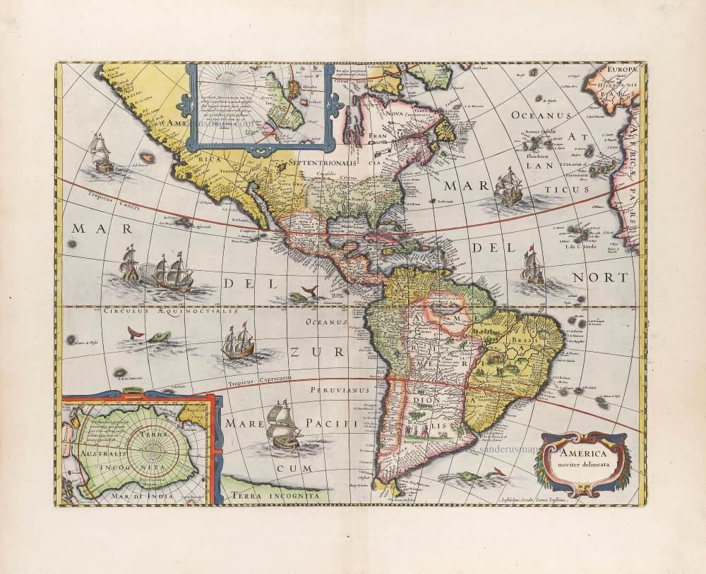
America, by Willem Blaeu. 1647-49
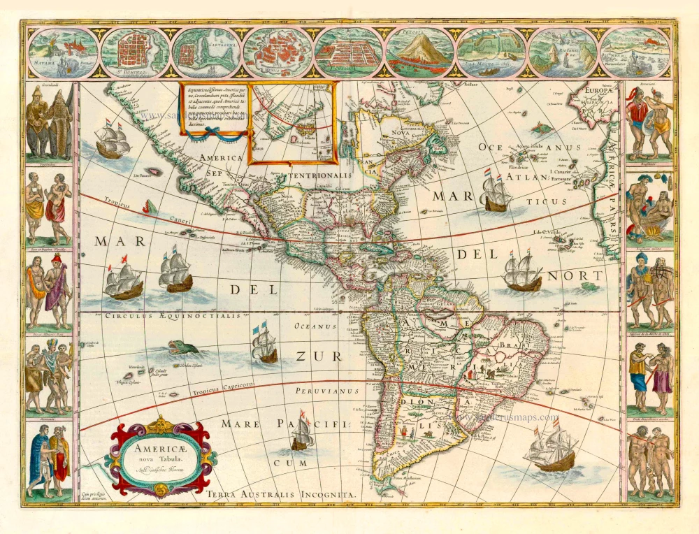
The inclusion of three decorative borders greatly enhances this map's visual appeal. The one above contains nine plans or views of towns. The side panels each have five portraits of figures. These are drawn from various sources, including Theodore de Bry.
"In the same year, the results of Jacob le Maire and Willem Cornelisz Schouten's voyage around Cape Horn became known. They showed that Tierra del Fuego was an island and not connected to the unknown southern continent. Due to lawsuits filed between the Australian Company and the Dutch East India Company, Blaeu was legally barred from incorporating this new information on his maps and globes in July 1617. This restriction was not lifted until August of the following year. Blaeu immediately updated this work to include *Fretum le Maire and State landt*. He also removed the coastline of *TERRA AUSTRALIS INCOGNITA* east of the title cartouche, mysteriously leaving the name behind. Therefore state 1 of the plate, having a life of at most about eighteen months, is extremely rare. Indeed, as late as 1955, only one example was known.
A third state was revised, changing the name to Blaeu in 1621. Keuning wrote in detail about this period and the various forms in which we find his name. The change resulted from Jan Jansz's competition and the apparent similarities of their names. This state was to appear through to 1630 without text on the reverse. It also appeared in this form in the *Atlantis Appendix.* This was Blaeu's first attempt at a world atlas, primarily instigated by his purchase in 1629 of several Jodocus Hondius' plates. In the following years, he would experiment with various formats." (Burden)
The Blaeus: Willem Janszoon, Cornelis & Joan
Willem Jansz. Blaeu and his son Joan Blaeu are the seventeenth century's most widely known cartographic publishers.
Willem Jansz. (also written Guilielmus Janssonius) = Willem Janszoon Blaeu was born in Uitgeest (Netherlands), near Alkmaar, in 1571. He studied mathematics under Tycho Brahe and learned the theory and practice of astronomical observations and the art of instrument- and globe-making.
In 1596, he came to Amsterdam, where he settled down as a globe-, instrument- and map-maker. He published his first cartographic work (a globe) in 1599 and probably published his first printed map (a map of the Netherlands) in 1604. He specialised in maritime cartography, published the first edition of the pilot guide Het Licht der Zeevaert in 1608, and was appointed Hydrographer of the V.O.C. (United East India Company) in 1633. After publishing books, wall maps, globes, charts and pilot guides for thirty years, he brought out his first atlas, Atlas Appendix (1630). This was the beginning of the great tradition of atlas-making by the Blaeus.
In 1618, another mapmaker, bookseller and publisher, Johannes Janssonius, established himself in Amsterdam next door to Blaeu's shop. No wonder these two neighbours began accusing each other of copying and stealing their information and became fierce competitors who did not have a good word to say about each other. In about 1621 Willem Jansz. decided to end the confusion between his name and his competitor's and assumed his grandfather's nickname, 'blauwe Willem' ('blue Willem'), as the family name; after that, he called himself Willem Jansz. Blaeu.
Willem Janszoon Blaeu died in 1638, leaving his prospering business to his sons, Cornelis and Joan. We only know that Cornelis's name occurs in the prefaces of books and atlases until c. 1645.
Joan Blaeu, born in Amsterdam in 1596, became a partner in his father’s book trade and printing business. 1638, he was appointed his father’s successor in the Hydrographic Office of the V.O.C. His efforts culminated in the magnificent Atlas Major and the town books of the Netherlands and Italy – works unsurpassed in history and modern times, giving eternal fame to the name of the Blaeu's.
On February 23, 1672, a fire ruined the business. One year later, Dr Joan Blaeu died. The fire of 1672 and the passing away of the director gave rise to a complete sale of the stock of the Blaeu House. Five public auctions dispersed the remaining books, atlases, copperplates, globes, etc., among many other map dealers and publishers in Amsterdam. The majority was acquired by several booksellers acting in partnership.
In the succeeding years, the remaining printing department was left in the hands of the Blaeu family until 1695, when the printing house's inventory was sold at a public auction. That meant the end of the Blaeu's as a printing house of world renown.
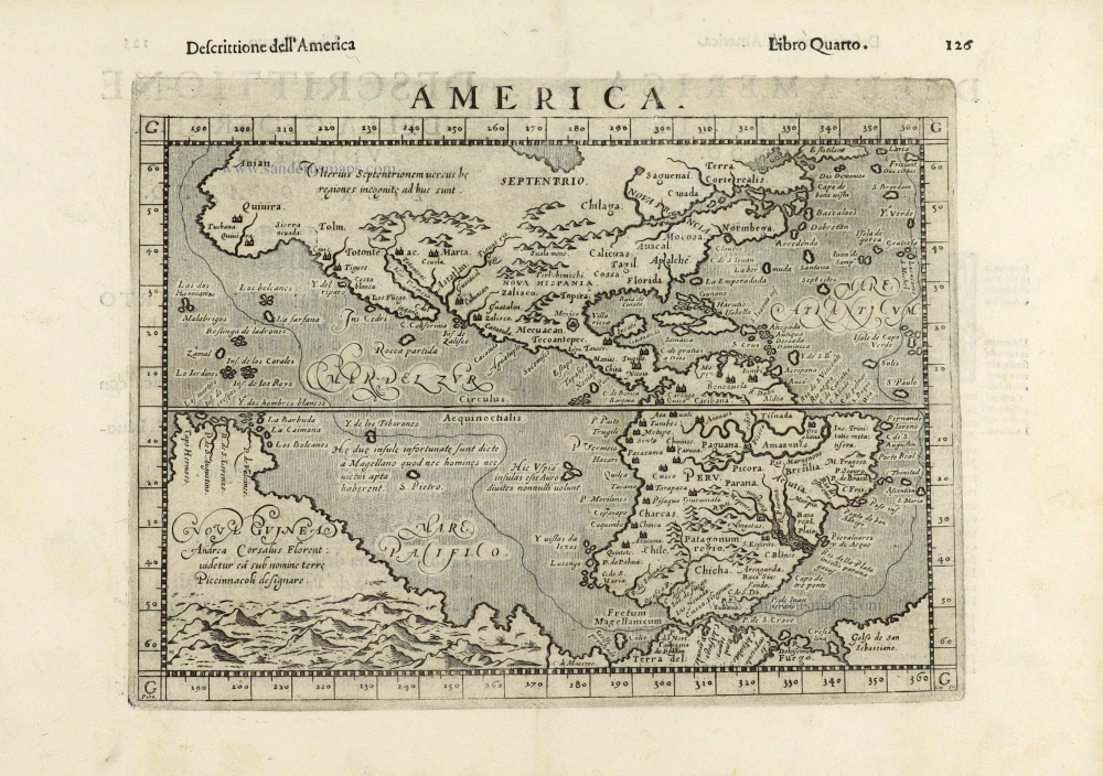
Americae nova Tabula.
Item Number: 6717 Authenticity Guarantee
Category: Antique maps > America > The Americas
Old antique map of America by W. Blaeu.
Title: Americae nova Tabula.
Date of the first edition: 1617.
Date of this map: 1647-49.
Copper engraving, printed on paper.
Size (not including margins): 410 x 555mm (16.14 x 21.85 inches).
Verso: German text.
Condition: Original coloured, excellent.
Condition Rating: A+.
From: Novus Atlas, Das ist, Weltbeschreibung, ... Amsterdam, 1647-49. (Van der Krogt 2, 232)
The inclusion of three decorative borders greatly enhances this map's visual appeal. The one above contains nine plans or views of towns. The side panels each have five portraits of figures. These are drawn from various sources, including Theodore de Bry.
"In the same year, the results of Jacob le Maire and Willem Cornelisz Schouten's voyage around Cape Horn became known. They showed that Tierra del Fuego was an island and not connected to the unknown southern continent. Due to lawsuits filed between the Australian Company and the Dutch East India Company, Blaeu was legally barred from incorporating this new information on his maps and globes in July 1617. This restriction was not lifted until August of the following year. Blaeu immediately updated this work to include *Fretum le Maire and State landt*. He also removed the coastline of *TERRA AUSTRALIS INCOGNITA* east of the title cartouche, mysteriously leaving the name behind. Therefore state 1 of the plate, having a life of at most about eighteen months, is extremely rare. Indeed, as late as 1955, only one example was known.
A third state was revised, changing the name to Blaeu in 1621. Keuning wrote in detail about this period and the various forms in which we find his name. The change resulted from Jan Jansz's competition and the apparent similarities of their names. This state was to appear through to 1630 without text on the reverse. It also appeared in this form in the *Atlantis Appendix.* This was Blaeu's first attempt at a world atlas, primarily instigated by his purchase in 1629 of several Jodocus Hondius' plates. In the following years, he would experiment with various formats." (Burden)
The Blaeus: Willem Janszoon, Cornelis & Joan
Willem Jansz. Blaeu and his son Joan Blaeu are the seventeenth century's most widely known cartographic publishers.
Willem Jansz. (also written Guilielmus Janssonius) = Willem Janszoon Blaeu was born in Uitgeest (Netherlands), near Alkmaar, in 1571. He studied mathematics under Tycho Brahe and learned the theory and practice of astronomical observations and the art of instrument- and globe-making.
In 1596, he came to Amsterdam, where he settled down as a globe-, instrument- and map-maker. He published his first cartographic work (a globe) in 1599 and probably published his first printed map (a map of the Netherlands) in 1604. He specialised in maritime cartography, published the first edition of the pilot guide Het Licht der Zeevaert in 1608, and was appointed Hydrographer of the V.O.C. (United East India Company) in 1633. After publishing books, wall maps, globes, charts and pilot guides for thirty years, he brought out his first atlas, Atlas Appendix (1630). This was the beginning of the great tradition of atlas-making by the Blaeus.
In 1618, another mapmaker, bookseller and publisher, Johannes Janssonius, established himself in Amsterdam next door to Blaeu's shop. No wonder these two neighbours began accusing each other of copying and stealing their information and became fierce competitors who did not have a good word to say about each other. In about 1621 Willem Jansz. decided to end the confusion between his name and his competitor's and assumed his grandfather's nickname, 'blauwe Willem' ('blue Willem'), as the family name; after that, he called himself Willem Jansz. Blaeu.
Willem Janszoon Blaeu died in 1638, leaving his prospering business to his sons, Cornelis and Joan. We only know that Cornelis's name occurs in the prefaces of books and atlases until c. 1645.
Joan Blaeu, born in Amsterdam in 1596, became a partner in his father’s book trade and printing business. 1638, he was appointed his father’s successor in the Hydrographic Office of the V.O.C. His efforts culminated in the magnificent Atlas Major and the town books of the Netherlands and Italy – works unsurpassed in history and modern times, giving eternal fame to the name of the Blaeu's.
On February 23, 1672, a fire ruined the business. One year later, Dr Joan Blaeu died. The fire of 1672 and the passing away of the director gave rise to a complete sale of the stock of the Blaeu House. Five public auctions dispersed the remaining books, atlases, copperplates, globes, etc., among many other map dealers and publishers in Amsterdam. The majority was acquired by several booksellers acting in partnership.
In the succeeding years, the remaining printing department was left in the hands of the Blaeu family until 1695, when the printing house's inventory was sold at a public auction. That meant the end of the Blaeu's as a printing house of world renown.
Related items
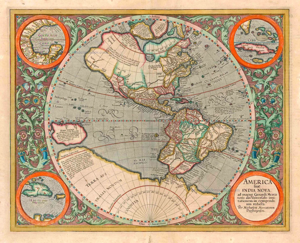
America sive India Nova ad magnae Gerardi Mercatoris avi Universalis imitationem in compendium redacta. 1623
America, by Gerard Mercator
[Item number: 131]

America 1602
America by Langenes, published by Bertius P.
[Item number: 12494]
California as an island
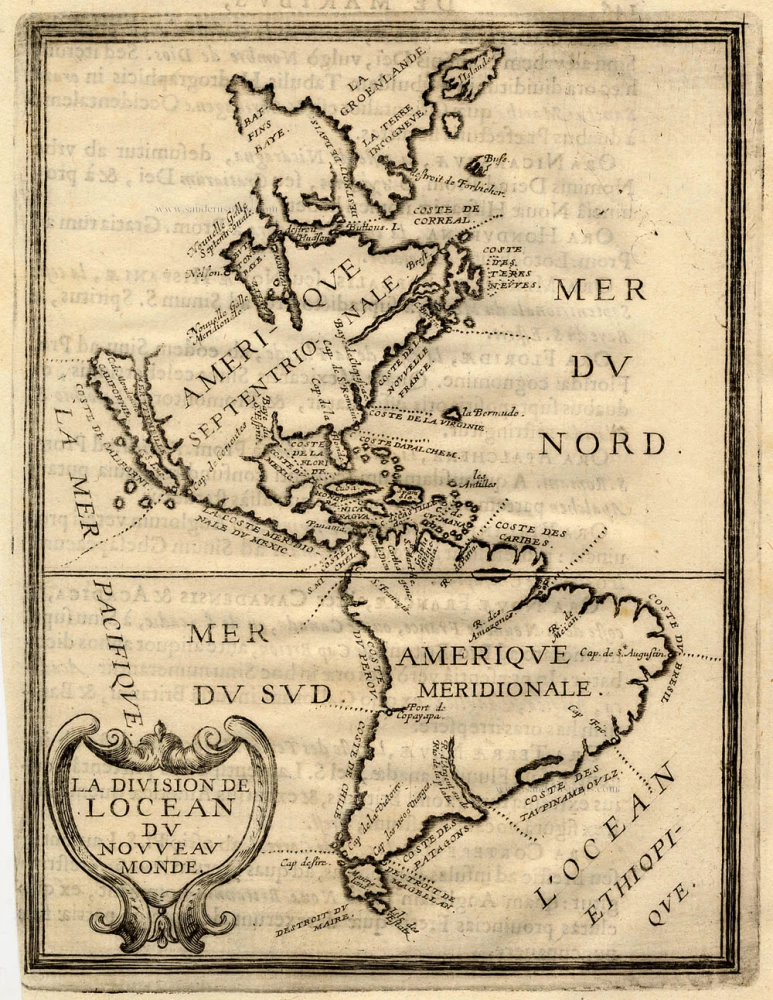
La Division de l'Ocean du Nouveau Monde 1648
America, by Briet Ph.
[Item number: 17771]
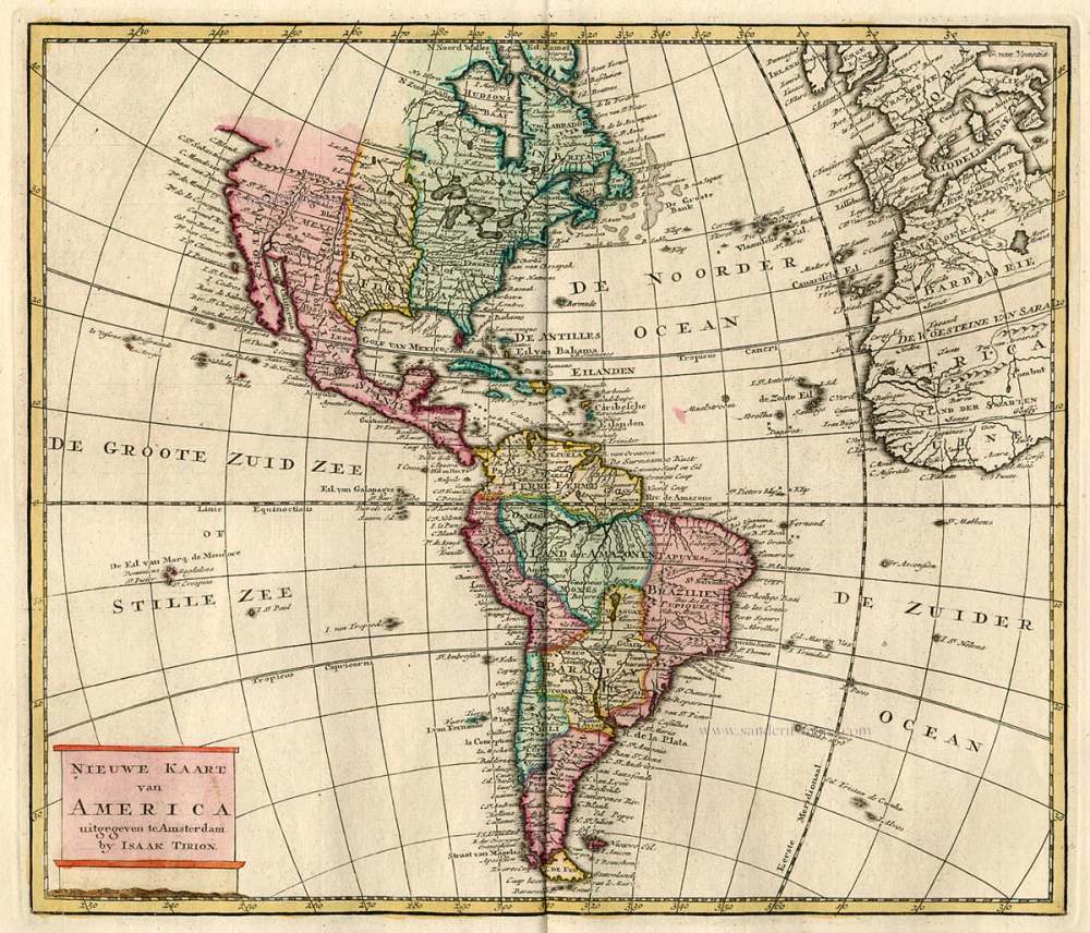
Nieuwe Kaart van America c. 1770
Antique map of America by Tirion I.
[Item number: 19194]

America. 1597
AMERICA by Giovanni Magini
[Item number: 22492]
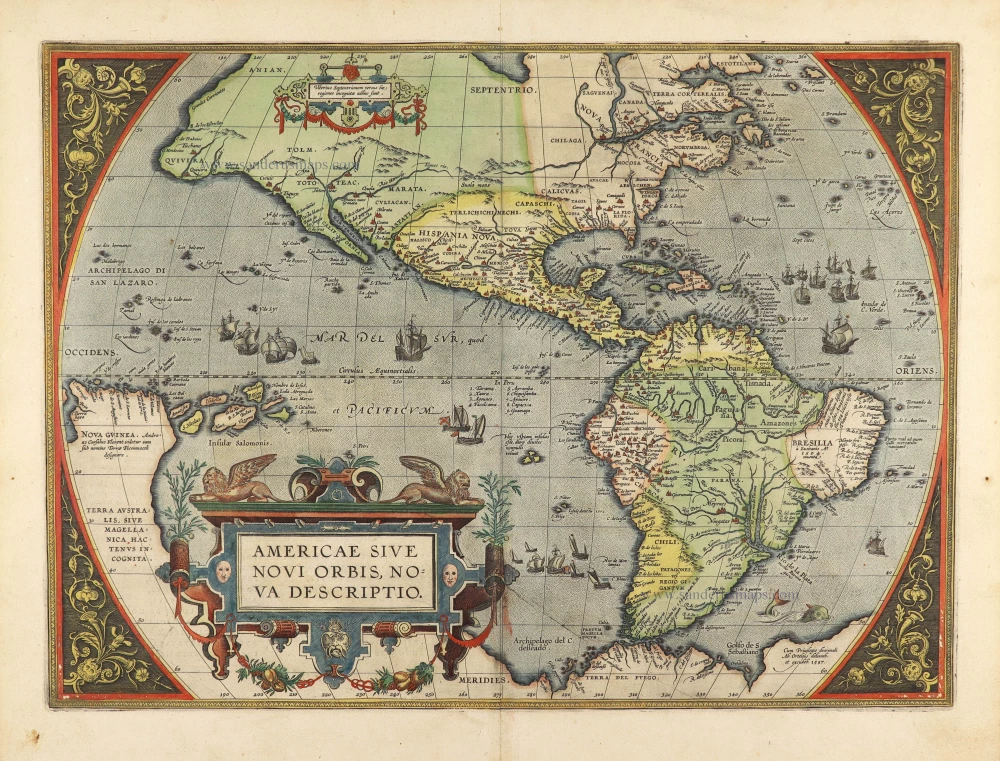
Americae Sive Novi Orbis, Nova Descriptio. 1603
America by Abraham Ortelius.
[Item number: 27538]
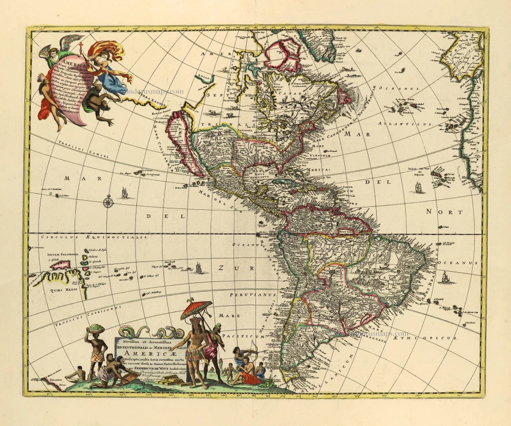
Novissima et Accuratissima Septentrionalis ac Meridionalis Americae. c. 1715
America by Frederick de Wit, published by Covens & Mortier.
[Item number: 28295]
California as an island
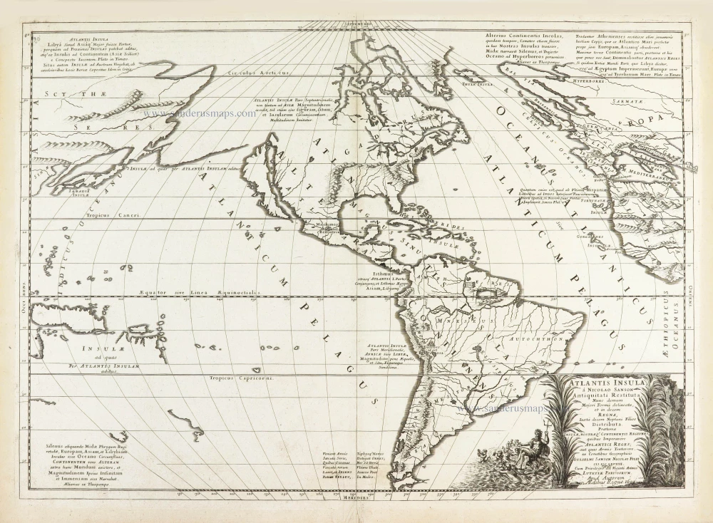
Atlantis Insula. 1692
The Americas by Guillaume Sanson.
[Item number: 28376]
America. 1598
America, by Giovanni Lorenzo d'Anania, published by Girolamo Ruscelli.
[Item number: 28432]
America. 1613
America by Jodocus Hondius.
[Item number: 28530]
Novissima et Accuratissima Totius Americae Descriptio. 1656-77
America by Nicolaes Visscher I.
[Item number: 28554]
First plate
Americae Sive Novi Orbis, Nova Descriptio. 1572
America by Abraham Ortelius.
[Item number: 29237]
One of the most elaborately engraved maps ever published.
Carte tres Curieuse de la Mer du Sud, Contenant des Remarques Nouvelles et tres Utiles non Seulement sur les Ports et Iles de cette Mer, 1719
Pacific by Zacharias Châtelain after Nicolas de Fer.
[Item number: 29466]
Luxury colour.
America noviter delineata. 1666
America by Jodocus Hondius Jr, published by Joannes Janssonius.
[Item number: 29790]
First state
Atlantis Insula. 1667-69
The Americas and the Pacific and Atlantic Ocean by Guillaume Sanson.
[Item number: 29999]
Le table des neufues lesquelles on appelle isles d'Occident & d'Indie pour divers regard. 1555
America by Sebastian Münster.
[Item number: 30379]
new
Le table des neufues lesquelles on appelle isles d'Occident & d'Indie pour divers regard. 1568
America by Sebastian Münster.
[Item number: 30518]