
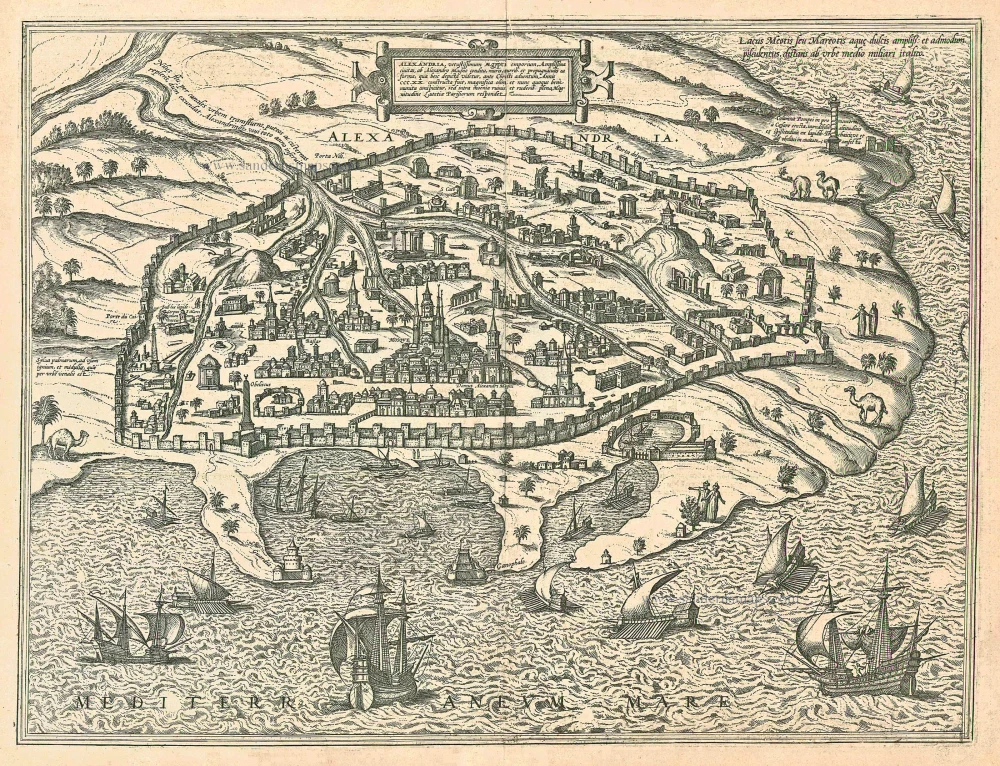
Egypt - Alexandria by Georg Braun & Frans Hogenberg 1623
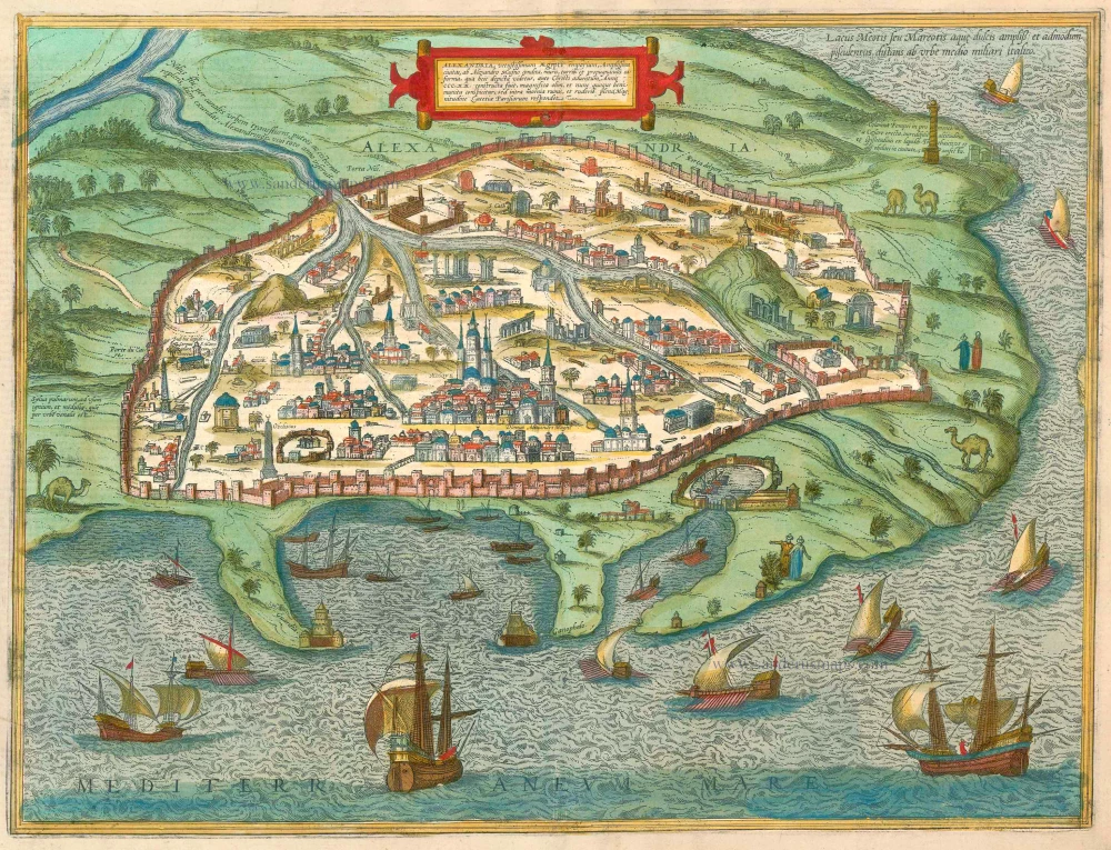
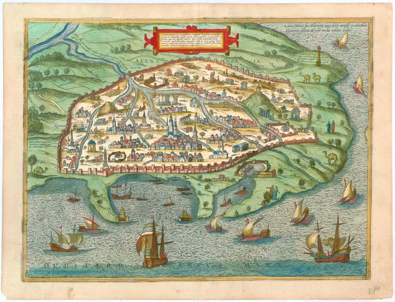


TRANSLATION OF CARTOUCHE TEXT: Alexandria , ancient Egyptian centre of trade, a huge town, founded by Alexander the Great; it was built in 320 BC with walls, towers and fortifications; once magnificent and even today well fortified, but inside its walls full of ruins and rubble, it is comparable in size to Paris.
COMMENTARY BY BRAUN (on verso): "Alexandria is rectangular in shape and has four gates. The first leads toward the Nile, the next to the south toward the lake, the third to the west toward the desert, the fourth toward the Mediterranean; where the harbour is located. Toll keepers and common servants search travellers there down to their skin since duty must be paid not only on their wares but also on every last cent they carry."
Alexandria is depicted as a sprawling, formidably fortified town, crisscrossed by multiple arms of the river and where few buildings, but many ruins, stand. Alexandria was founded by Alexander the Great on the Nile Delta and, under the Ptolemaic Empire, was extended to become the capital of Egypt. In the 16th century Alexandria was still used as a commercial port, but it lost its political and economic importance after its capture by the Arabs in AD 642. During its heyday the city was renowned in particular for both its culture and science: the library of Alexandria was the largest in the ancient world, and was affiliated with the Musaeum, a celebrated school of philology. The lighthouse at Alexandria, the Pharos, one of the Seven Wonders of the Ancient World, is also identifiable on a peninsula to the left. Today, with 3.87 milion residents, Alexandria is once again a major international commercial port due to its location on the Suez Canal. (Taschen)
Braun G. & Hogenberg F. and the Civitates Orbis Terrarum.
The Civitates Orbis Terrarum, or the "Braun & Hogenberg", is a six-volume town atlas and the most excellent book of town views and plans ever published: 363 engravings, sometimes beautifully coloured. It was one of the best-selling works in the last quarter of the 16th century. Georg Braun wrote the text accompanying the plans and views on the verso. Many plates were engraved after the original drawings of a professional artist, a professional artist, Joris Hoefnagel (1542-1600). The first volume was published in Latin in 1572, and the sixth in 1617. Frans Hogenberg created the tables for volumes I through IV, and Simon van den Neuwel made those for volumes V and VI. Other contributors were cartographers Daniel Freese and Heinrich Rantzau. Works by Jacob van Deventer, Sebastian Münster, and Johannes Stumpf were also used. Translations appeared in German and French.
Following the original publication of Volume 1 of the Civitates in 1572, seven further editions of 1575, 1577, 1582, 1588, 1593, 1599 and 1612 can be identified. Vol.2, first issued in 1575, was followed by further editions in 1597 and 1612. The subsequent volumes appeared in 1581, 1588, 1593, 1599 and 1606. The German translation of the first volume appeared from 1574 on, and the French edition from 1575 on.
Several printers were involved: Theodor Graminaeus, Heinrich von Aich, Gottfried von Kempen, Johannis Sinniger, Bertram Buchholtz and Peter von Brachel, who all worked in Cologne.
Georg Braun (1541-1622)
Georg Braun was born in Cologne in 1541. After his studies in Cologne, he entered the Jesuit Order as a novice. 1561, he obtained his bachelor's degree, and in 1562, he received his Magister Artium. Although he left the Jesuit Order, he studied theology, gaining a licentiate in theology.
Frans Hogenberg (1535-1590)
Frans Hogenberg was a Flemish and German painter, engraver, and mapmaker. He was born in Mechelen as the son of Nicolaas Hogenberg.
By the end of the 1560s, Frans Hogenberg was employed upon Abraham Ortelius's Theatrum Orbis Terrarum, published in 1570; he is named an engraver of numerous maps. In 1568, he was banned from Antwerp by the Duke of Alva and travelled to London, where he stayed a few years before emigrating to Cologne. He immediately embarked on his two most important works, the Civitates, published in 1572 and the Geschichtsblätter, which appeared in several series from 1569 until about 1587.
Thanks to large-scale projects like the Geschichtsblätter and the Civitates, Hogenberg's social circumstances improved with each passing year. He died as a wealthy man in Cologne in 1590.
Alexandria, Vetustissimum Aegypti Emporium, Amplissima Civitas .Penon de Veles
Item Number: 23291 Authenticity Guarantee
Category: Antique maps > Africa
Old, antique bird's-eye view plan of Alexandria (Egypt), by Georg Braun and Frans Hogenberg.
Date of the first edition: 1575
Date of this map: 1623
Copper engraving, printed on paper.
Size (not including margins): 36.5 x 48cm (14.2 x 18.7 inches)
Verso text: Latin
Condition: Excellent, superb old colour.
Condition Rating: A
References: Van der Krogt 4, #66; Fauser, #175; Taschen, Br. Hog., p.187.
From: Civitates Orbis Terrarum, ... Part 2: De Praecipuis, Totius Universi Urbibus, Liber Secundus. Köln, Petrus von Brachel, 1623. (Van der Krogt 4, 41:1.2)
TRANSLATION OF CARTOUCHE TEXT: Alexandria , ancient Egyptian centre of trade, a huge town, founded by Alexander the Great; it was built in 320 BC with walls, towers and fortifications; once magnificent and even today well fortified, but inside its walls full of ruins and rubble, it is comparable in size to Paris.
COMMENTARY BY BRAUN (on verso): "Alexandria is rectangular in shape and has four gates. The first leads toward the Nile, the next to the south toward the lake, the third to the west toward the desert, the fourth toward the Mediterranean; where the harbour is located. Toll keepers and common servants search travellers there down to their skin since duty must be paid not only on their wares but also on every last cent they carry."
Alexandria is depicted as a sprawling, formidably fortified town, crisscrossed by multiple arms of the river and where few buildings, but many ruins, stand. Alexandria was founded by Alexander the Great on the Nile Delta and, under the Ptolemaic Empire, was extended to become the capital of Egypt. In the 16th century Alexandria was still used as a commercial port, but it lost its political and economic importance after its capture by the Arabs in AD 642. During its heyday the city was renowned in particular for both its culture and science: the library of Alexandria was the largest in the ancient world, and was affiliated with the Musaeum, a celebrated school of philology. The lighthouse at Alexandria, the Pharos, one of the Seven Wonders of the Ancient World, is also identifiable on a peninsula to the left. Today, with 3.87 milion residents, Alexandria is once again a major international commercial port due to its location on the Suez Canal. (Taschen)
Braun G. & Hogenberg F. and the Civitates Orbis Terrarum.
The Civitates Orbis Terrarum, or the "Braun & Hogenberg", is a six-volume town atlas and the most excellent book of town views and plans ever published: 363 engravings, sometimes beautifully coloured. It was one of the best-selling works in the last quarter of the 16th century. Georg Braun wrote the text accompanying the plans and views on the verso. Many plates were engraved after the original drawings of a professional artist, a professional artist, Joris Hoefnagel (1542-1600). The first volume was published in Latin in 1572, and the sixth in 1617. Frans Hogenberg created the tables for volumes I through IV, and Simon van den Neuwel made those for volumes V and VI. Other contributors were cartographers Daniel Freese and Heinrich Rantzau. Works by Jacob van Deventer, Sebastian Münster, and Johannes Stumpf were also used. Translations appeared in German and French.
Following the original publication of Volume 1 of the Civitates in 1572, seven further editions of 1575, 1577, 1582, 1588, 1593, 1599 and 1612 can be identified. Vol.2, first issued in 1575, was followed by further editions in 1597 and 1612. The subsequent volumes appeared in 1581, 1588, 1593, 1599 and 1606. The German translation of the first volume appeared from 1574 on, and the French edition from 1575 on.
Several printers were involved: Theodor Graminaeus, Heinrich von Aich, Gottfried von Kempen, Johannis Sinniger, Bertram Buchholtz and Peter von Brachel, who all worked in Cologne.
Georg Braun (1541-1622)
Georg Braun was born in Cologne in 1541. After his studies in Cologne, he entered the Jesuit Order as a novice. 1561, he obtained his bachelor's degree, and in 1562, he received his Magister Artium. Although he left the Jesuit Order, he studied theology, gaining a licentiate in theology.
Frans Hogenberg (1535-1590)
Frans Hogenberg was a Flemish and German painter, engraver, and mapmaker. He was born in Mechelen as the son of Nicolaas Hogenberg.
By the end of the 1560s, Frans Hogenberg was employed upon Abraham Ortelius's Theatrum Orbis Terrarum, published in 1570; he is named an engraver of numerous maps. In 1568, he was banned from Antwerp by the Duke of Alva and travelled to London, where he stayed a few years before emigrating to Cologne. He immediately embarked on his two most important works, the Civitates, published in 1572 and the Geschichtsblätter, which appeared in several series from 1569 until about 1587.
Thanks to large-scale projects like the Geschichtsblätter and the Civitates, Hogenberg's social circumstances improved with each passing year. He died as a wealthy man in Cologne in 1590.
Related items
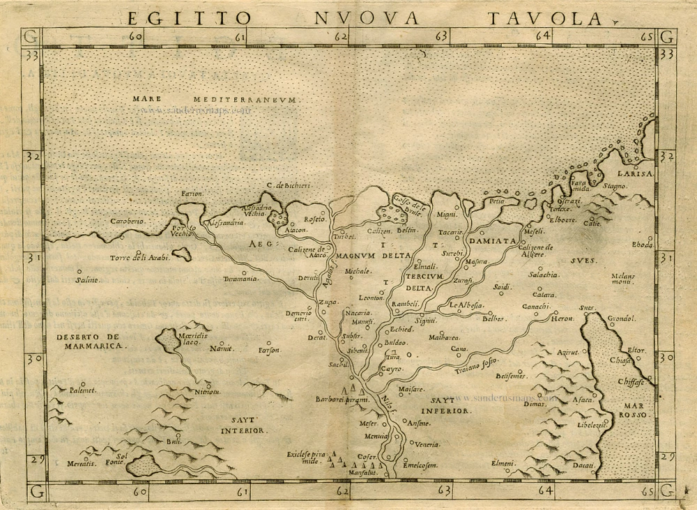
Egitto Nuva Tavola. 1562
Egypt by Ruscelli G.
[Item number: 6470]
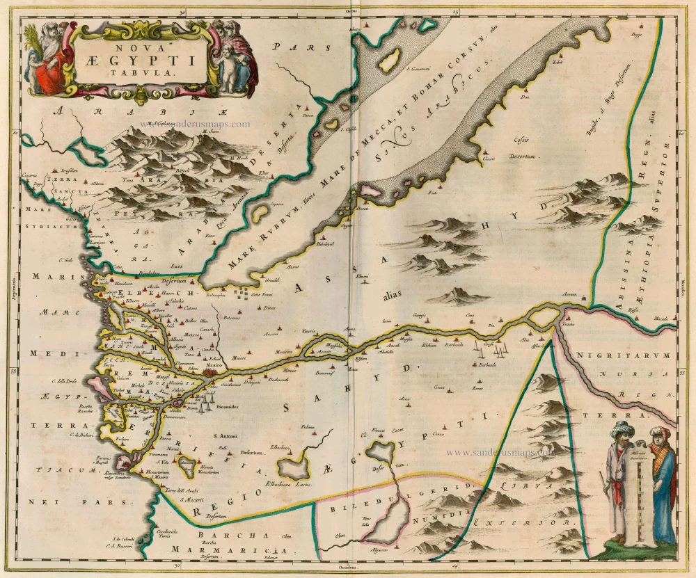
Nova Aegypti Tabula 1662
Egypt, by Joan Blaeu.
[Item number: 22818]
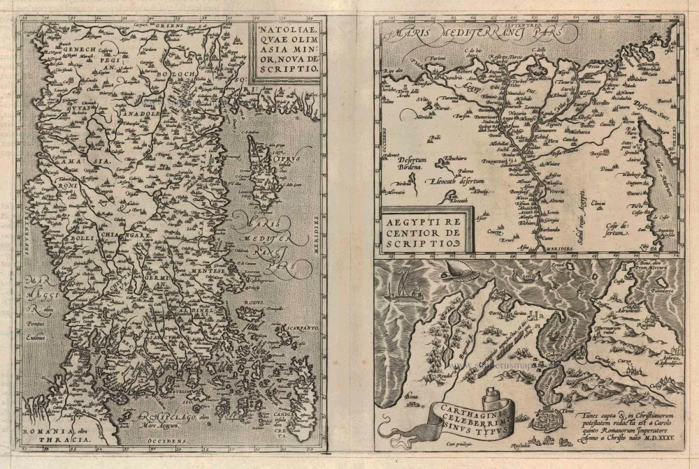
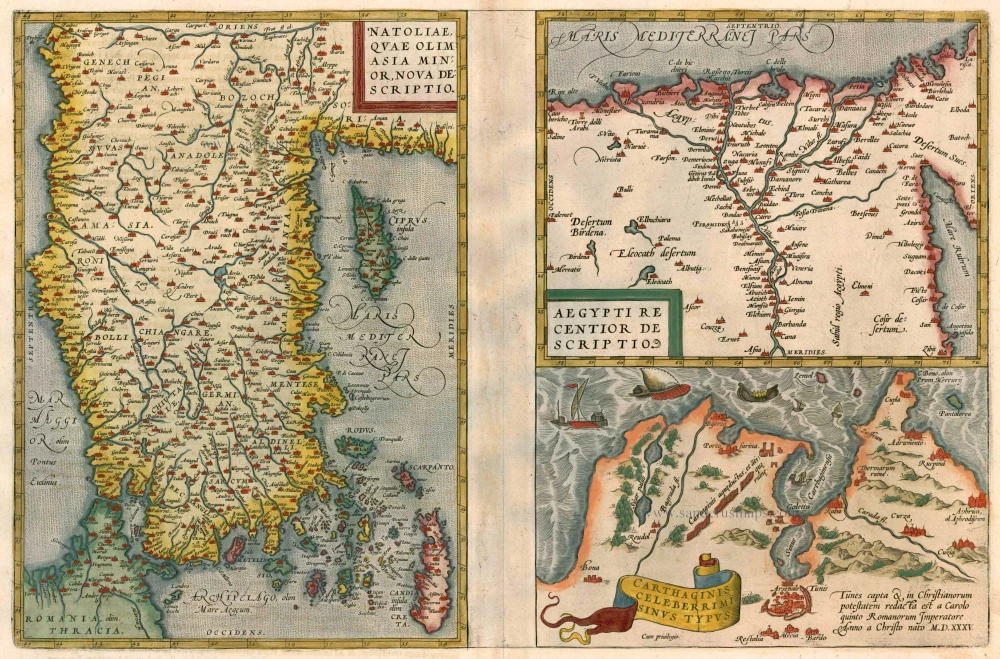
Natoliae quae olim Asia Minor [on sheet with] Argypti Recentioe Descriptio [and] Carthaginis Celeberrimi Sinus Typus 1598
Turkey - Egypt - Cartago, by A. Ortelius.
[Item number: 22865]
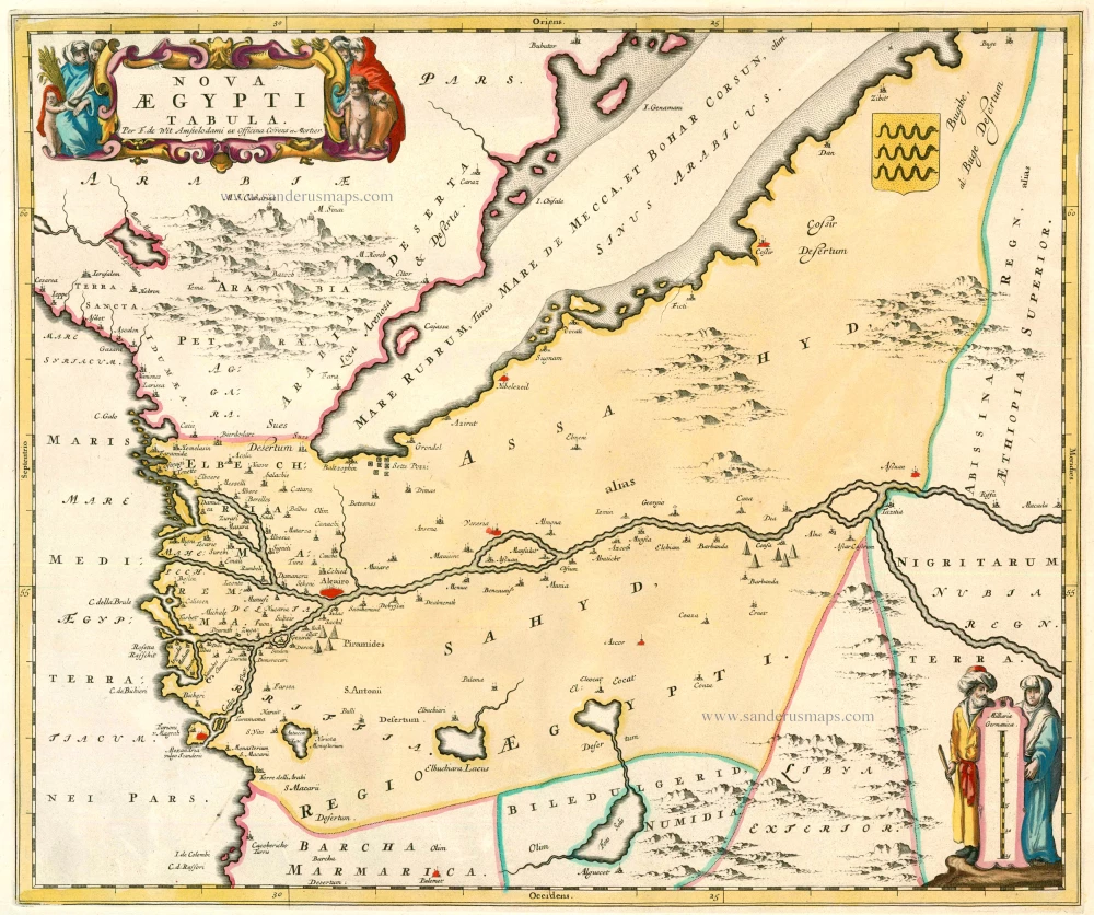
Nova Aegypti Tabula 1721-41
Egypt, by F. De Wit after Blaeu.
[Item number: 23616]
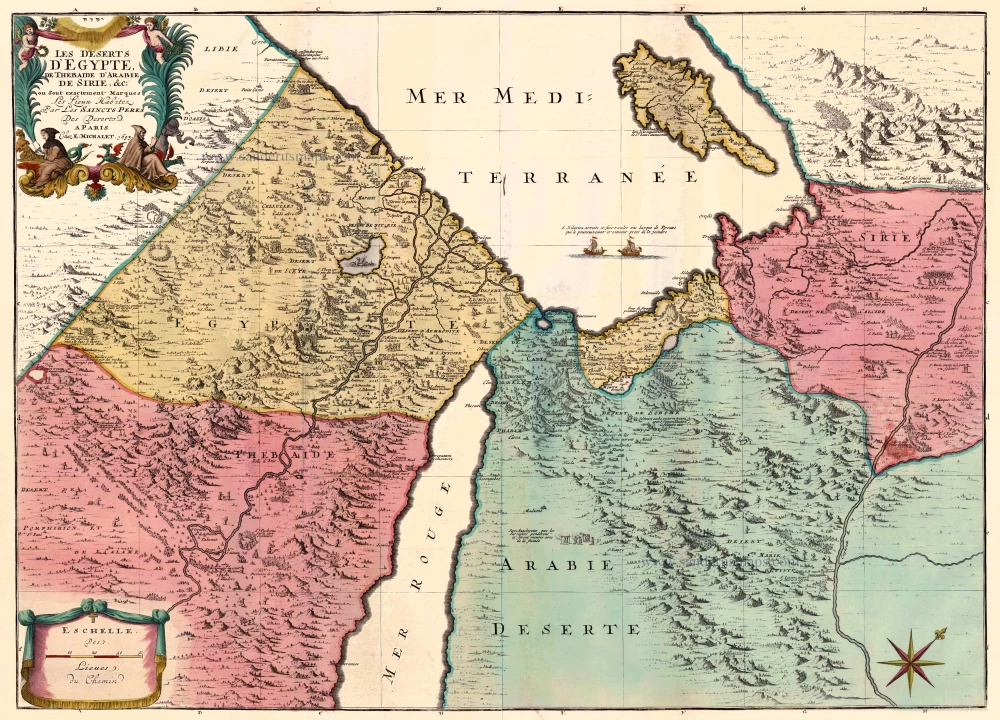
Les Deserts d'Egypte, de Thebaide d'Arabie, de Sirie, &c., ou sont Exactement Marques les Lieux Habitez par les Saincts Peres des Deserts 1710
Egypt and the Middle East by Jaillot - Covens & Mortier.
[Item number: 23617]
Alexandria, Vetustissimum Aegypti Emporium, Amplissima Civitas .Penon de Veles. 1597
Egypt - Alexandria by Georg Braun & Frans Hogenberg
[Item number: 24010]
Nova Aegypti Tabula. c. 1680
Egypt, by Joan Blaeu, published by Frederick de Wit.
[Item number: 10610]
Natoliae quae olim Asia Minor [on sheet with] Argypti Recentioe Descriptio [and] Carthaginis Celeberrimi Sinus Typus 1612
Turkey - Egypt - Cartago by Ortelius A.
[Item number: 22800]

Aegyptus Hodierna. 1716-37
Egypt, by Johann Baptist Homann.
[Item number: 20813]
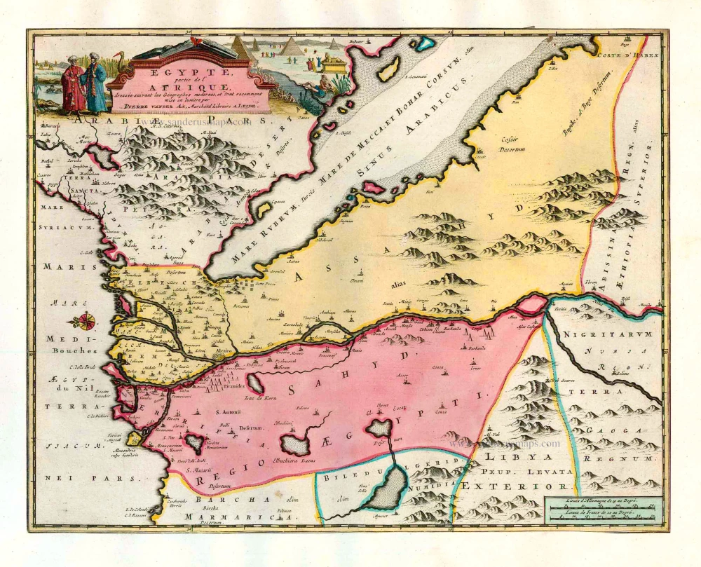
Egypte, partie de l'Afrique. 1713
Egypt, by Pieter van der Aa.
[Item number: 26133]