
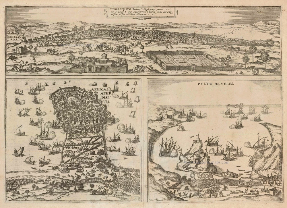
Tunis, Mahdia and Penon de Veles, by Georg Braun and Frans Hogenberg. 1575
Braun G. & Hogenberg F. and the Civitates Orbis Terrarum.
The Civitates Orbis Terrarum, or the "Braun & Hogenberg", is a six-volume town atlas and the most excellent book of town views and plans ever published: 363 engravings, sometimes beautifully coloured. It was one of the best-selling works in the last quarter of the 16th century. Georg Braun wrote the text accompanying the plans and views on the verso. Many plates were engraved after the original drawings of a professional artist, a professional artist, Joris Hoefnagel (1542-1600). The first volume was published in Latin in 1572, and the sixth in 1617. Frans Hogenberg created the tables for volumes I through IV, and Simon van den Neuwel made those for volumes V and VI. Other contributors were cartographers Daniel Freese and Heinrich Rantzau. Works by Jacob van Deventer, Sebastian Münster, and Johannes Stumpf were also used. Translations appeared in German and French.
Following the original publication of Volume 1 of the Civitates in 1572, seven further editions of 1575, 1577, 1582, 1588, 1593, 1599 and 1612 can be identified. Vol.2, first issued in 1575, was followed by further editions in 1597 and 1612. The subsequent volumes appeared in 1581, 1588, 1593, 1599 and 1606. The German translation of the first volume appeared from 1574 on, and the French edition from 1575 on.
Several printers were involved: Theodor Graminaeus, Heinrich von Aich, Gottfried von Kempen, Johannis Sinniger, Bertram Buchholtz and Peter von Brachel, who all worked in Cologne.
Georg Braun (1541-1622)
Georg Braun was born in Cologne in 1541. After his studies in Cologne, he entered the Jesuit Order as a novice. 1561, he obtained his bachelor's degree, and in 1562, he received his Magister Artium. Although he left the Jesuit Order, he studied theology, gaining a licentiate in theology.
Frans Hogenberg (1535-1590)
Frans Hogenberg was a Flemish and German painter, engraver, and mapmaker. He was born in Mechelen as the son of Nicolaas Hogenberg.
By the end of the 1560s, Frans Hogenberg was employed upon Abraham Ortelius's Theatrum Orbis Terrarum, published in 1570; he is named an engraver of numerous maps. In 1568, he was banned from Antwerp by the Duke of Alva and travelled to London, where he stayed a few years before emigrating to Cologne. He immediately embarked on his two most important works, the Civitates, published in 1572 and the Geschichtsblätter, which appeared in several series from 1569 until about 1587.
Thanks to large-scale projects like the Geschichtsblätter and the Civitates, Hogenberg's social circumstances improved with each passing year. He died as a wealthy man in Cologne in 1590.
Tunes Oppidum Barbarie & Regina fedes 1535 ... [on sheet with] Africa olim Aphrodisum [and] Penon de Veles
Item Number: 22314 Authenticity Guarantee
Category: Antique maps > Africa
Old, antique map with three bird's-eye views by Braun and Hogenberg: Tunis, Mahdia and Penon de Veles.
TUNIS
TRANSLATION OF CARTOUCHE TEXT: Tunis, town of the Berbers and royal seat, drawn true to life in 1535 by Johannes Maius, His Majesty's court painter, following its capture by Emperor Charles V.
COMMENTARY BY BRAUN: "There are many clothe weavers in this town, for the women normally do nothing else but spin very fine and delicate thread, the cloth made from this is traded all over Africa and fetches high prices. ... There is no river, no spring or sea; thus the inhabitants make use of rainwater, which they collect in cisterns. Only on the outskirts of town is there a saltwater spring, out of which numerous carriers bring the water into town to sell. Otherwise there is also a freshwater lake, but this is reserved for the princes and courtiers."
MAHDIA (AL-MAHDIYA)
CAPTION: Africa, once called Aphrodisium.
COMMENTARY BY BRAUN: "Aphrodisium, which is now commonly called Africa, but by the Moors Mahdia, lies in the sea ... The acces from land is so formidably fortified with immense towers, labyrinthine walls and outfitted with tower galleries and hideouts that it stretches the powers of the imagination. Hence the Moors considered it unassailable.'
The bird's-eye view depicts the Peninsula of Mahdia, Aphrodisium or Africa in the throes of deadly battle on the water and on land. In 1546 the pirate Turgut Reis, following the death of Admiral Khair ad-Din, called Barbarossa, became the new commander-in-chief of the Ottoman naval forces. He besieged and plundered such places as Sicily and Calabria and attacked the Spanish bases in North Africa. In 1549 he captured the town of Mahdia, supremely protected by defensive labyrinthine walls. The plate depicts the massive recapture at sea and on land by the Spanish Admiral Andrea Doria and the Maltese Claude de la Sengle in September 1550. Mahdia, or the Horn of Africa, is located on an ancient site, which in the 16th century was thought to be Ptolemy's Aphrodisium.
PEÑON DE VÉLEZ DE LA GOMERA
COMMENTARY BY BRAUN: "Peñon de Vélez is a very old town on the shore of the Mediterranean; it was called Velles de Gumenera or Pennon de Velles by the Spaniards and more than 600 families reside there. It is located between two high mountains. Fresh water is a rare commodity for them since they must all use a watering hole located on the outskirts of town. The citizens are divided into two groups: many of them are fishermen, the others are pirates, who brings the Christians great misfortune."
The plate depicts a small rocky island under siege cannon fire from the land as well as from the sea. Fortifications with towers, walls and planted flags can be identified on the sheer cliffs of the island. The Spanish, battling the resident pirates there, initially captured the island in 1508. Afterwards it fell under Moroccan rule for 42 years until the Spanish won it back 1564. Because the island was occupied constantly and difficult to hold, it was allegedly blown up in 1871. (Taschen)
The view is made after an engraving by Giovanni Francesco Camocio, c 1570.
Date of the first edition: 1575
Date of this map: 1575
Copper engraving
Size: 33 x 47cm (12.9 x 18.3 inches)
Verso text: Blank
Condition: Uncoloured, excellent.
Condition Rating: A
References: Van der Krogt 4, 4516; Taschen, Braun and Hogenberg, p.198.
From: Civitates Orbis Terrarum, ... Part 2: De Praecipuis, Totius Universi Urbibus, Liber Secundus. Köln, Gottfried von Kempen, 1575. (Van der Krogt 4, 41:1.2)
Braun G. & Hogenberg F. and the Civitates Orbis Terrarum.
The Civitates Orbis Terrarum, or the "Braun & Hogenberg", is a six-volume town atlas and the most excellent book of town views and plans ever published: 363 engravings, sometimes beautifully coloured. It was one of the best-selling works in the last quarter of the 16th century. Georg Braun wrote the text accompanying the plans and views on the verso. Many plates were engraved after the original drawings of a professional artist, a professional artist, Joris Hoefnagel (1542-1600). The first volume was published in Latin in 1572, and the sixth in 1617. Frans Hogenberg created the tables for volumes I through IV, and Simon van den Neuwel made those for volumes V and VI. Other contributors were cartographers Daniel Freese and Heinrich Rantzau. Works by Jacob van Deventer, Sebastian Münster, and Johannes Stumpf were also used. Translations appeared in German and French.
Following the original publication of Volume 1 of the Civitates in 1572, seven further editions of 1575, 1577, 1582, 1588, 1593, 1599 and 1612 can be identified. Vol.2, first issued in 1575, was followed by further editions in 1597 and 1612. The subsequent volumes appeared in 1581, 1588, 1593, 1599 and 1606. The German translation of the first volume appeared from 1574 on, and the French edition from 1575 on.
Several printers were involved: Theodor Graminaeus, Heinrich von Aich, Gottfried von Kempen, Johannis Sinniger, Bertram Buchholtz and Peter von Brachel, who all worked in Cologne.
Georg Braun (1541-1622)
Georg Braun was born in Cologne in 1541. After his studies in Cologne, he entered the Jesuit Order as a novice. 1561, he obtained his bachelor's degree, and in 1562, he received his Magister Artium. Although he left the Jesuit Order, he studied theology, gaining a licentiate in theology.
Frans Hogenberg (1535-1590)
Frans Hogenberg was a Flemish and German painter, engraver, and mapmaker. He was born in Mechelen as the son of Nicolaas Hogenberg.
By the end of the 1560s, Frans Hogenberg was employed upon Abraham Ortelius's Theatrum Orbis Terrarum, published in 1570; he is named an engraver of numerous maps. In 1568, he was banned from Antwerp by the Duke of Alva and travelled to London, where he stayed a few years before emigrating to Cologne. He immediately embarked on his two most important works, the Civitates, published in 1572 and the Geschichtsblätter, which appeared in several series from 1569 until about 1587.
Thanks to large-scale projects like the Geschichtsblätter and the Civitates, Hogenberg's social circumstances improved with each passing year. He died as a wealthy man in Cologne in 1590.
Related items
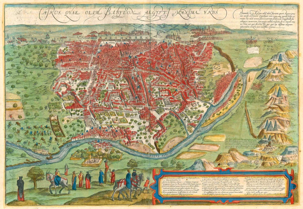
Cairus, quae olim Babylon; Aegypti Maxima Urbs. 1599
Cairo, by Georg Braun and Frans Hogenberg.
[Item number: 23244]
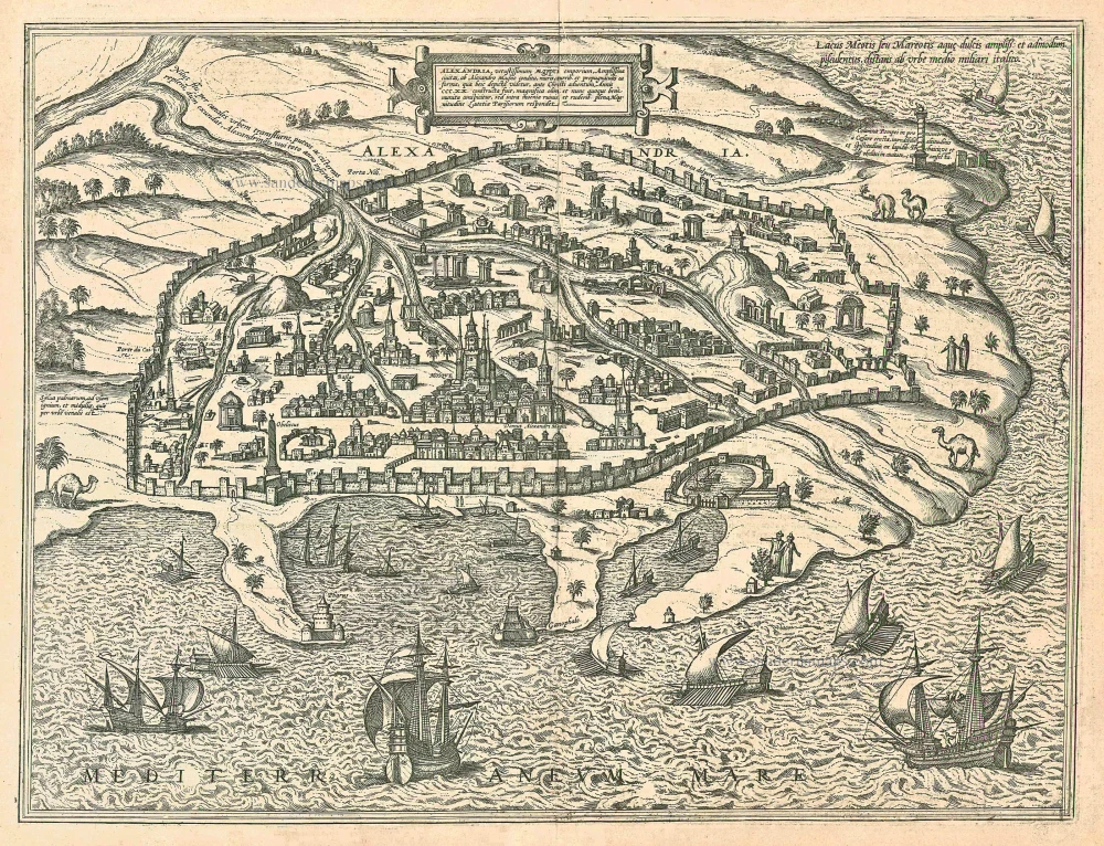
Alexandria, Vetustissimum Aegypti Emporium, Amplissima Civitas .Penon de Veles. 1597
Egypt - Alexandria by Georg Braun & Frans Hogenberg
[Item number: 24010]
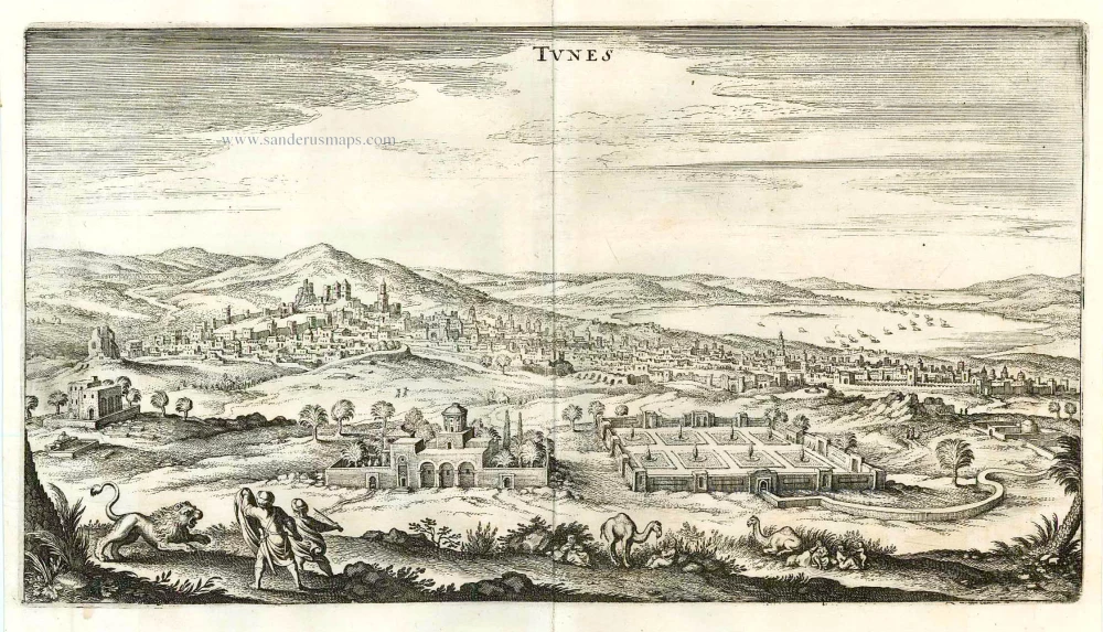
Tunes. 1638
Tunis by M. Merian.
[Item number: 25950]
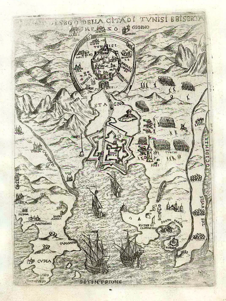
Il vero disego della cita di Tunisi e Biserta. c. 1575
Bizerte by Giovanni Francesco Camocio
[Item number: 27630]
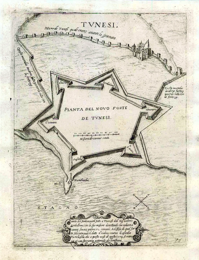
Tunesi. Pianta del novo forte de Tunesi. c. 1575
Tunisia by Giovanni Francesco Camocio
[Item number: 27631]