
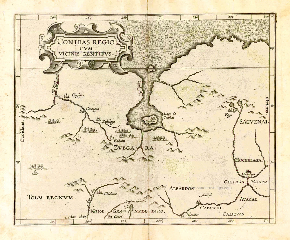
Central Canada by Cornelis van Wytfliet 1607
In 1597 Cornelis van Wytfliet published his Augmentum to Ptolemy's Geography. This is true as much as it covers all the Americas, a part of the world unknown to the latter; however, no other connection exists. Dedicated to Philip III of Spain, it is a history of the New World, recording its discovery, natural history etc. For the book, Wytfliet had engraved nineteen maps, by whom we do not know, one of the world and eighteen regional maps of the Americas. This book can be indeed called the first atlas of America. It was an immediate success and ran to several editions.
Despite the fact that this map covers territory virtually unknown to the Europeans, it owes its existence to the fact that Wytfliet showed every part of the continent however little knowledge there was of it. This is, however, the first printed map of present-day central Canada. The basic cartography derives from Gerard Mercator's world map of 1569, which first depicted a large body of water inland in the extreme north. There has been much speculation as to what this might refer to; it has been suggested that it could be a record of a voyage unknown to us that visited Hudson Bay, it could even be remnants of the Verrazzano sea theory. At the top of the map, we find the North-West Passage. On a number of maps at this time various rivers are shown flowing north into these waters; no possible explanation can be given for this other than the assumption that in such a vast expanse of land there would be some. Some sense of the extent of the map can be seen by the incorporation of the Septem civitates of the south-west, and Hochelega, or Montreal, in the east.
There exist three states of the map, all of which appeared in one of the three different issues in 1597. Because of the speed of change, it is likely that one cannot assign specific states to particular editions." (Burden)
The copy here is the one with the name of the islands erased and the name Higuater above the 280° meridian.
Cornelius Wytfliet (? – 1597)
Cornelius Wytfliet was a geographer from Leuven. After graduating with a Licentiate in Laws from the University of Leuven, Wytfliet moved to Brussels and became secretary to the Council of Brabant.
In 1597, he published the first atlas of America: the Descriptionis Ptolemaicae Augmentum (Augmentation to Ptolemy’s description). He named his work an augmentation of Ptolemy’s Geography because it covers the Americas, a part of the world unknown to Ptolemy. However, there is no other connection between the works of Ptolemy and Van Wytfliet. Dedicated to Philip III of Spain, it is a history of the New World to date, recording its discovery, natural history, etc. It provides a history of exploration and the voyages of Christopher Columbus (1492-1502), John Cabot (1497-98), Sebastian Cabot (1526-28), Francisco Pizarro (1527-35), Giovanni de Verazzano (1524), Jacques Cartier (1540-42), and Martin Frobisher (1576-78). Most of Van Wytfliet’s maps are the first or among the earliest of specific regions of North and South America.
For the book, Wytfliet had engraved nineteen maps, one of the world and eighteen regional maps of the Americas. The book was an immediate success and ran to several editions.
Two editions of the Descriptionis Ptolemaicae were published at Leuven in 1597 and 1598, and in 1603, the first Douai edition appeared, with later editions with French text. The last edition was published in Arnhem in 1615.
Conibas Regio cum Vicinis Gentibus.
Item Number: 26506 Authenticity Guarantee
Category: Antique maps > America > North America
Old, antique map of Central Canada, by C. van Wytfliet.
Date of the first edition: 1597
Date of this map: 1607
Copper engraving, printed on paper.
Size (not including margins): 22 x 27cm (8.6 x 10.5 inches)
Verso: Blank
Condition: Excellent.
Condition Rating: A+
References: Van der Krogt 3, 9120:371 Variant C; Burden 100; Kershaw, #39 pl.23.
From: Histoire Universelle des Indes Occidentales. Douai, Françoes Fabri, 1607. (Van der Krogt 3, 371:12)
In 1597 Cornelis van Wytfliet published his Augmentum to Ptolemy's Geography. This is true as much as it covers all the Americas, a part of the world unknown to the latter; however, no other connection exists. Dedicated to Philip III of Spain, it is a history of the New World, recording its discovery, natural history etc. For the book, Wytfliet had engraved nineteen maps, by whom we do not know, one of the world and eighteen regional maps of the Americas. This book can be indeed called the first atlas of America. It was an immediate success and ran to several editions.
Despite the fact that this map covers territory virtually unknown to the Europeans, it owes its existence to the fact that Wytfliet showed every part of the continent however little knowledge there was of it. This is, however, the first printed map of present-day central Canada. The basic cartography derives from Gerard Mercator's world map of 1569, which first depicted a large body of water inland in the extreme north. There has been much speculation as to what this might refer to; it has been suggested that it could be a record of a voyage unknown to us that visited Hudson Bay, it could even be remnants of the Verrazzano sea theory. At the top of the map, we find the North-West Passage. On a number of maps at this time various rivers are shown flowing north into these waters; no possible explanation can be given for this other than the assumption that in such a vast expanse of land there would be some. Some sense of the extent of the map can be seen by the incorporation of the Septem civitates of the south-west, and Hochelega, or Montreal, in the east.
There exist three states of the map, all of which appeared in one of the three different issues in 1597. Because of the speed of change, it is likely that one cannot assign specific states to particular editions." (Burden)
The copy here is the one with the name of the islands erased and the name Higuater above the 280° meridian.
Cornelius Wytfliet (? – 1597)
Cornelius Wytfliet was a geographer from Leuven. After graduating with a Licentiate in Laws from the University of Leuven, Wytfliet moved to Brussels and became secretary to the Council of Brabant.
In 1597, he published the first atlas of America: the Descriptionis Ptolemaicae Augmentum (Augmentation to Ptolemy’s description). He named his work an augmentation of Ptolemy’s Geography because it covers the Americas, a part of the world unknown to Ptolemy. However, there is no other connection between the works of Ptolemy and Van Wytfliet. Dedicated to Philip III of Spain, it is a history of the New World to date, recording its discovery, natural history, etc. It provides a history of exploration and the voyages of Christopher Columbus (1492-1502), John Cabot (1497-98), Sebastian Cabot (1526-28), Francisco Pizarro (1527-35), Giovanni de Verazzano (1524), Jacques Cartier (1540-42), and Martin Frobisher (1576-78). Most of Van Wytfliet’s maps are the first or among the earliest of specific regions of North and South America.
For the book, Wytfliet had engraved nineteen maps, one of the world and eighteen regional maps of the Americas. The book was an immediate success and ran to several editions.
Two editions of the Descriptionis Ptolemaicae were published at Leuven in 1597 and 1598, and in 1603, the first Douai edition appeared, with later editions with French text. The last edition was published in Arnhem in 1615.
Related items
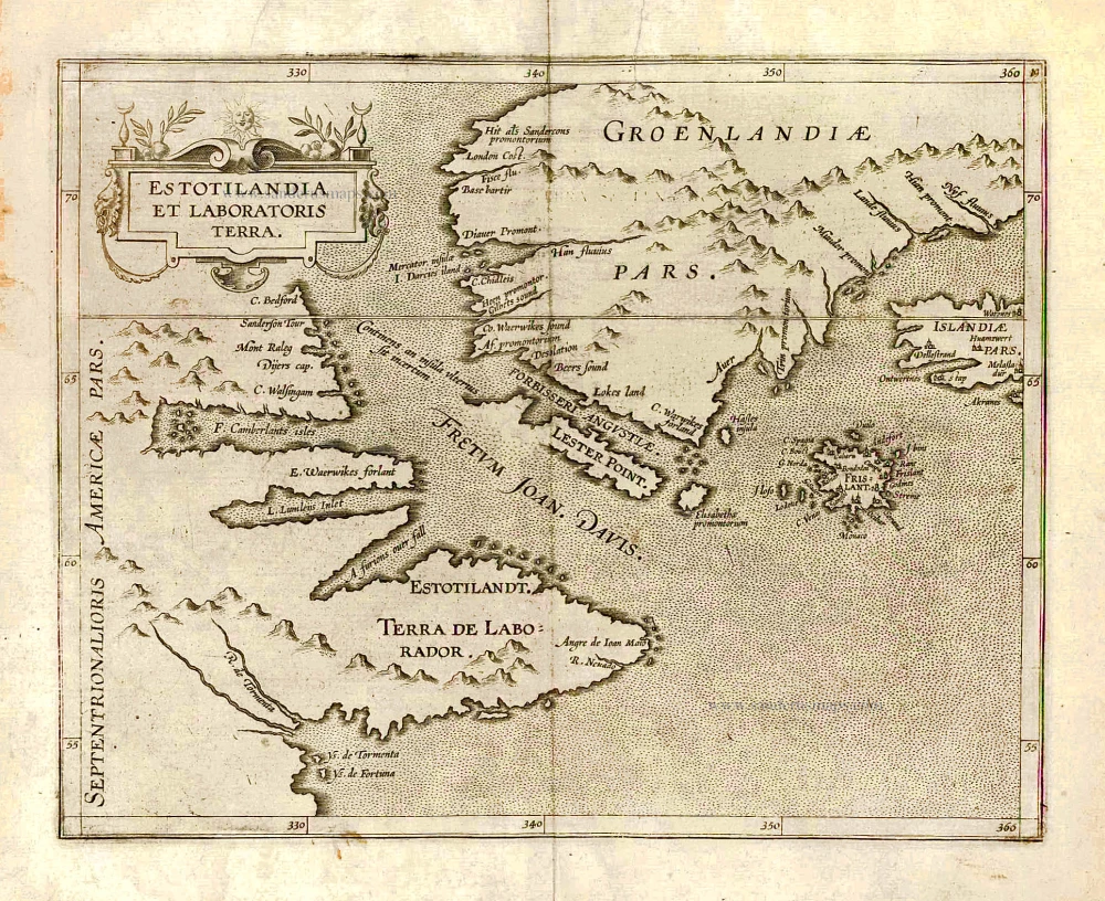
Estotilandia et Laboratoris Terra. 1607
Greenland and Northeast Canada, by C. van Wytfliet.
[Item number: 26499]
Important map
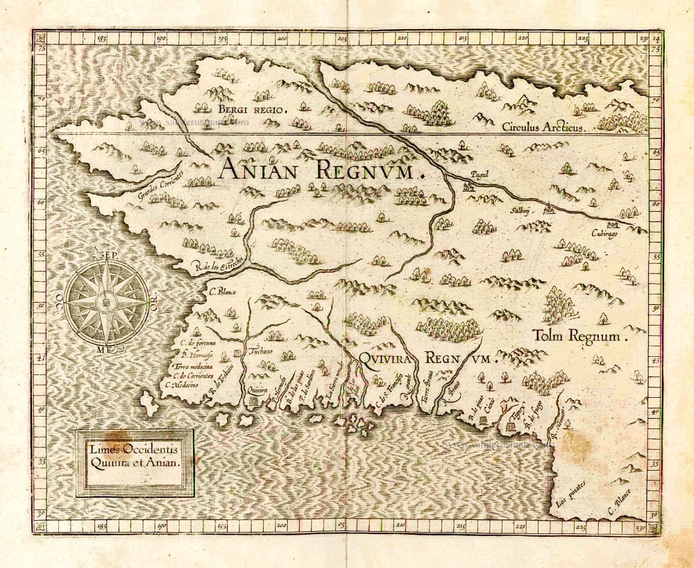
Limes Occidentis Quivira et Anian. 1607
West coast by Wytfliet, Cornelis van
[Item number: 26513]
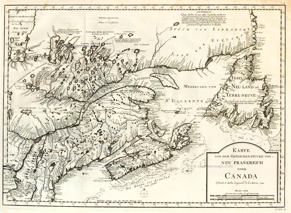
Karte von dem Ostlichen-Stucke von Neu Frankreich oder Canada. 1747-74
Eastern Canada, by Jacques Nicolas Bellin.
[Item number: 26796]
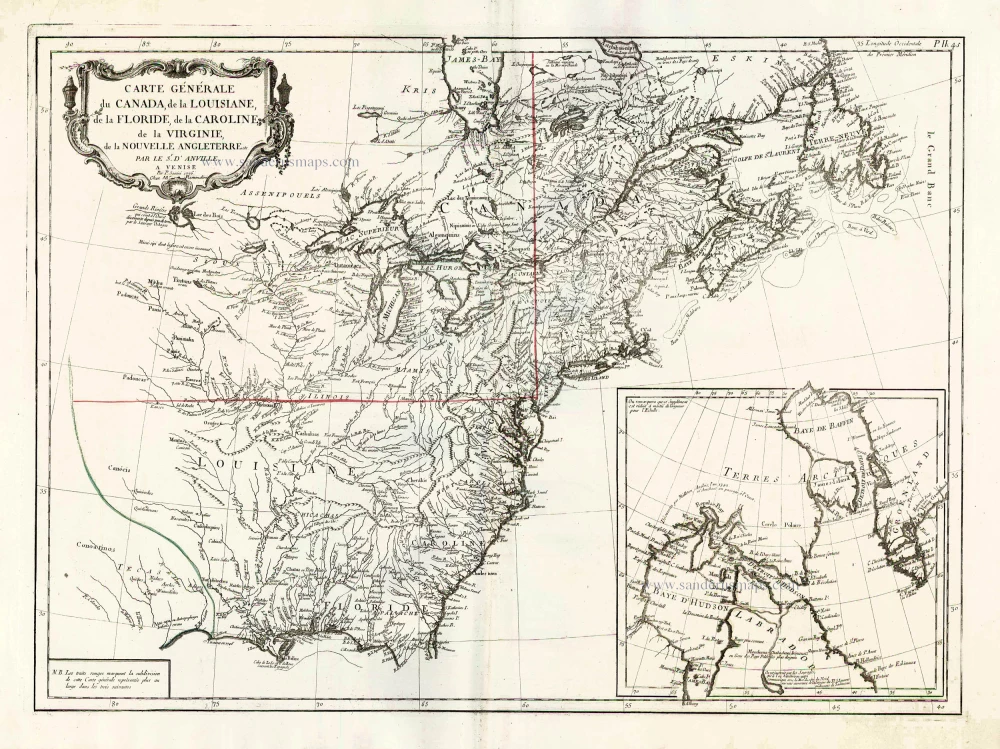
Carte Générale du Canada, de la Louisiane, de la Floride, de la Caroline, de la Virginie, de la Nouvelle Angleterre etc. 1776-79
North America (East), by Paolo Santini.
[Item number: 26980]
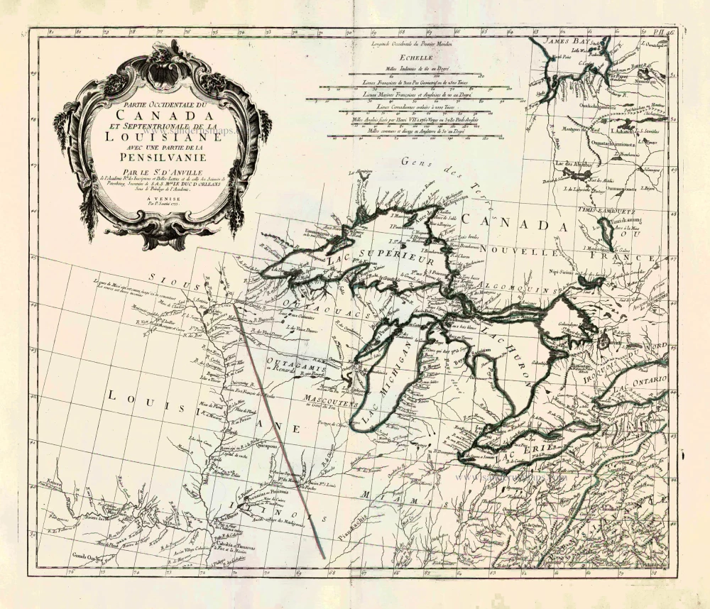
Partie Occidentale du Canada et Septentrionale de la Louisiane avec une Partie de la Pensilvani. 1776-79
Great Lakes, by Paolo Santini.
[Item number: 26981]
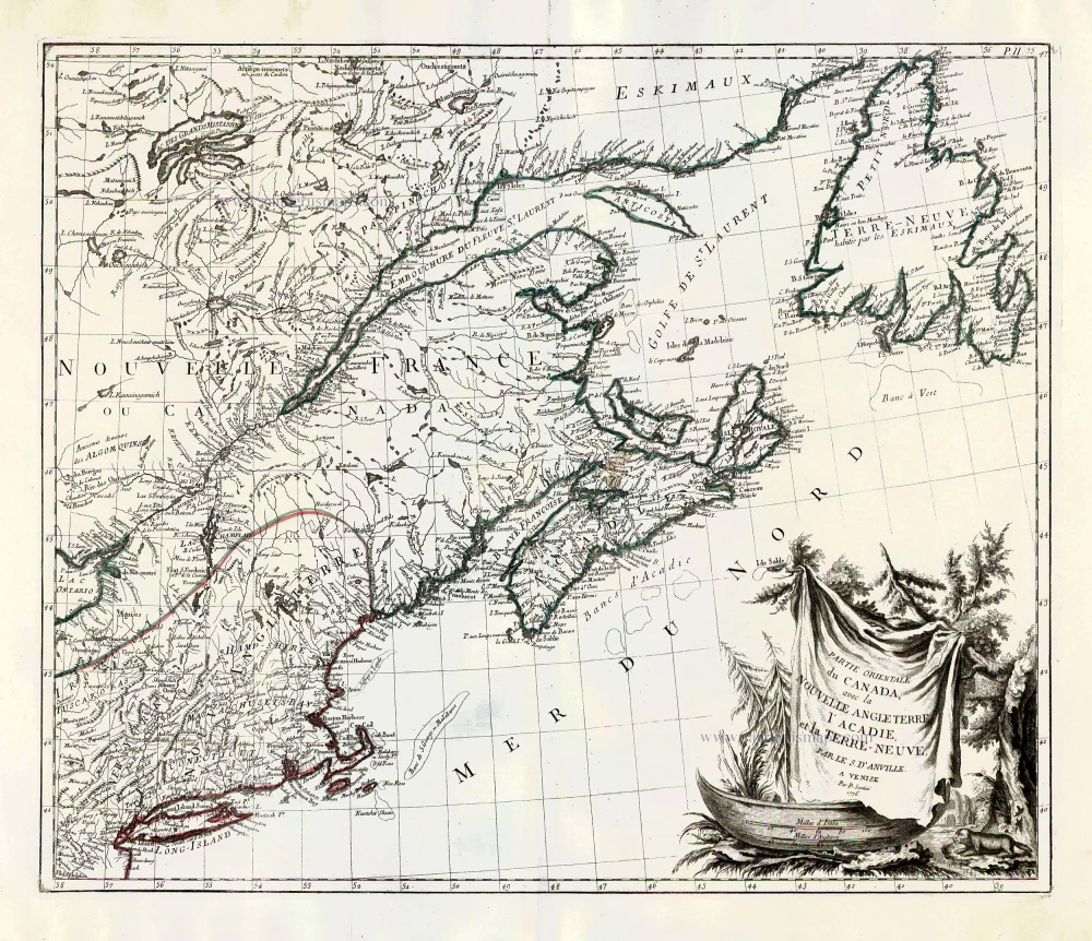
Partie Orientale du Canada, avec la Nouvelle Angleterre, l'Acadie, et la Terre-Neuve. 1776-79
New England and Northeastern Canada, by Paolo Santini.
[Item number: 26982]