
Pacific Ocean, by J. Van Keulen. 1680-1694
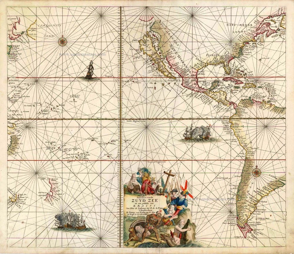
"The entire east coast of the Americas is shown. NIEU NEDERLANDT is still written large, holding on to the idea of a Dutch presence in North America which had ended in 1674, although recognition of the English possession is, in fact, given as Nieuw Yorck is identified without mention of the Dutch name New Amsterdam. Verginia is given greater prominence. California is altered to reflect the more recent belief of a double bay northern coastline first depicted by Luke Foxe in 1635. Here van Keulen draws upon the Pieter Goos form of 1663 with a mainland peninsula labelled Agubela de Cato, and a Straet Anian immediately to the north of it.
The extent of the map into Asia is not as far as the Janssonius, although in this region it draws upon the cartography of the Pieter Goos version, 1663. It records the discovery by Abel Tasman of New Zealand and Tasmania. The Gulf of Carpentaria, Australia, is featured as the mistaken COMPAGNIES LAND which was, in fact, one of the Kurile Islands." (Burden)
The House of Van Keulen
For more than two centuries, the chart makers firm of Van Keulen was established in the house with the name of “De Gekroonde Lootsman” (The Crowned Pilot). In 1678, the founder of the firm, Johannes I Van Keulen (1634-1689), registered with the Amsterdam booksellers’ guild. He had enlisted the aid of the well-known Mathematical Practitioner Claas Janz Vooght in the preparation of his nautical publications. In 1680 he published the first edition of the Zee-Atlas with 40 charts, all issued for the first time. In the short period of four years, they produced the five volumes of the Nieuwe Groote Ligtende Zee-Fakkel (1681-85). His acquisition of the stock of the bookseller Hendrik Doncker was an essential factor in the development of the firm.
In 1678 a son, Gerard Van Keulen (1678-1726), was born out of Johannes’s first marriage. This son was endowed with talent. He was a skilful engraver and proficient in mathematics and navigational science. Gerard was responsible for establishing the scientific basis of the firm of Van Keulen. In 1714 he was appointed to the office of hydrographer to the Dutch East India Company. The Van Keulens remained chart makers to the East India Company until the Company’s liquidation.
With the introductions to the Zee-Fakkel and Zee-Atlas, Gerard van Keulen gave a new impetus to the firm. Unfortunately, he did not live long, dying when he was 49. The business was carried on by his widow Ludwina Konst. Shortly before Gerard’s death, his son Johannes II had entered the bookseller’s guild, and in 1726 he assumed the management of the firm, though his mother retained her financial interests in the business.
Johannes II Van Keulen (1704-1755) is known in particular for his publication in 1753 of a sixth volume of the Zee-Fakkel, the volume containing the charts of the route to the East Indies.
Johannes II had two sons; they joined the firm as partners in 1757. A considerable number of books appeared in the period 1778-1801. New issues of the Zee-Fakkel again saw the light. The firm flourished under different names until 1885.
Pascaert vande Zuyd Zee en een Gedeelte van Brasil van Ilhas de Ladrones tot R. de la Plata ...
Item Number: 1849 Authenticity Guarantee
Category: Antique maps > Australia
Old, antique sea chart of the Pacific Ocean, by J. Van Keulen.
Insular California.
Date of the first edition: 1680
Date of this map: 1680-1690
Copper engraving
Size (not including margins): 52 x 59cm (20.3 x 23 inches)
Verso: Blank
Condition: Original coloured, with some reinforcements in the centre.
Condition Rating: A
References: Burden, #518 State 1; McLaughlin, #76; Tooley (America), #45; Tooley (Australia), #795; Wagner, #443; Clancy, p.110 Map 7.4.
From: De Groote Nieuwe Vermeerderde Zee-Atlas ofte Water-Werelt. ... Amsterdam, J. Van Keulen, 1680-1690. (Koeman, Keu2-19).
"The entire east coast of the Americas is shown. NIEU NEDERLANDT is still written large, holding on to the idea of a Dutch presence in North America which had ended in 1674, although recognition of the English possession is, in fact, given as Nieuw Yorck is identified without mention of the Dutch name New Amsterdam. Verginia is given greater prominence. California is altered to reflect the more recent belief of a double bay northern coastline first depicted by Luke Foxe in 1635. Here van Keulen draws upon the Pieter Goos form of 1663 with a mainland peninsula labelled Agubela de Cato, and a Straet Anian immediately to the north of it.
The extent of the map into Asia is not as far as the Janssonius, although in this region it draws upon the cartography of the Pieter Goos version, 1663. It records the discovery by Abel Tasman of New Zealand and Tasmania. The Gulf of Carpentaria, Australia, is featured as the mistaken COMPAGNIES LAND which was, in fact, one of the Kurile Islands." (Burden)
The House of Van Keulen
For more than two centuries, the chart makers firm of Van Keulen was established in the house with the name of “De Gekroonde Lootsman” (The Crowned Pilot). In 1678, the founder of the firm, Johannes I Van Keulen (1634-1689), registered with the Amsterdam booksellers’ guild. He had enlisted the aid of the well-known Mathematical Practitioner Claas Janz Vooght in the preparation of his nautical publications. In 1680 he published the first edition of the Zee-Atlas with 40 charts, all issued for the first time. In the short period of four years, they produced the five volumes of the Nieuwe Groote Ligtende Zee-Fakkel (1681-85). His acquisition of the stock of the bookseller Hendrik Doncker was an essential factor in the development of the firm.
In 1678 a son, Gerard Van Keulen (1678-1726), was born out of Johannes’s first marriage. This son was endowed with talent. He was a skilful engraver and proficient in mathematics and navigational science. Gerard was responsible for establishing the scientific basis of the firm of Van Keulen. In 1714 he was appointed to the office of hydrographer to the Dutch East India Company. The Van Keulens remained chart makers to the East India Company until the Company’s liquidation.
With the introductions to the Zee-Fakkel and Zee-Atlas, Gerard van Keulen gave a new impetus to the firm. Unfortunately, he did not live long, dying when he was 49. The business was carried on by his widow Ludwina Konst. Shortly before Gerard’s death, his son Johannes II had entered the bookseller’s guild, and in 1726 he assumed the management of the firm, though his mother retained her financial interests in the business.
Johannes II Van Keulen (1704-1755) is known in particular for his publication in 1753 of a sixth volume of the Zee-Fakkel, the volume containing the charts of the route to the East Indies.
Johannes II had two sons; they joined the firm as partners in 1757. A considerable number of books appeared in the period 1778-1801. New issues of the Zee-Fakkel again saw the light. The firm flourished under different names until 1885.
Related items
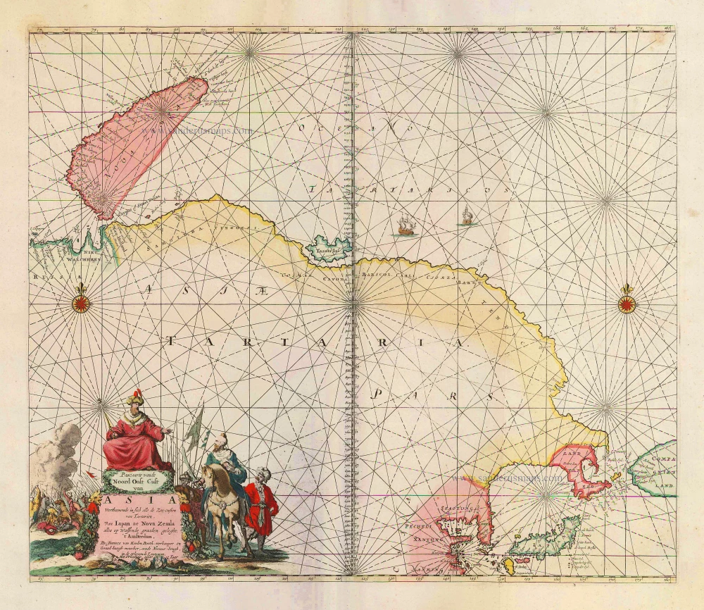
Pascaarte vande Noord Oost Cust van Asia Verthoonende in sich alle de Zee-custen van Tartarien, Van Iapan tot Nova Zemla, ... 1683
Sea chart of Northeast Asia, by J. Van Keulen.
[Item number: 2443]
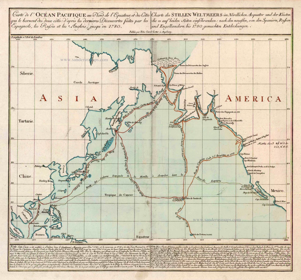
Carte de l'Ocean Pacifique au Nord de l'Equateur, et des Cotes qui le Bornent des Deux Cotes: D'Apres les Dernieres Decouvertes Faites par les Espagnols, les Russes et les Anglois, jusqu'en 1780. 1780
The Northern Pacific Ocean, by T.C. Lotter.
[Item number: 11984]

Caerte van de zeylage van Jacob le Maire over de Zuydzee, vertonende de Eylanden ende Landen aldaer by hem ghesien ende aenghedaen. / Tabula, ductum navigationis, quem in Mari Australi tenuit Iacobus Le Maire ... 1622
Rare chart showing the route taken by Schouten and le Maire from South America to New Guinea, by Michiel Colijn.
[Item number: 25104]
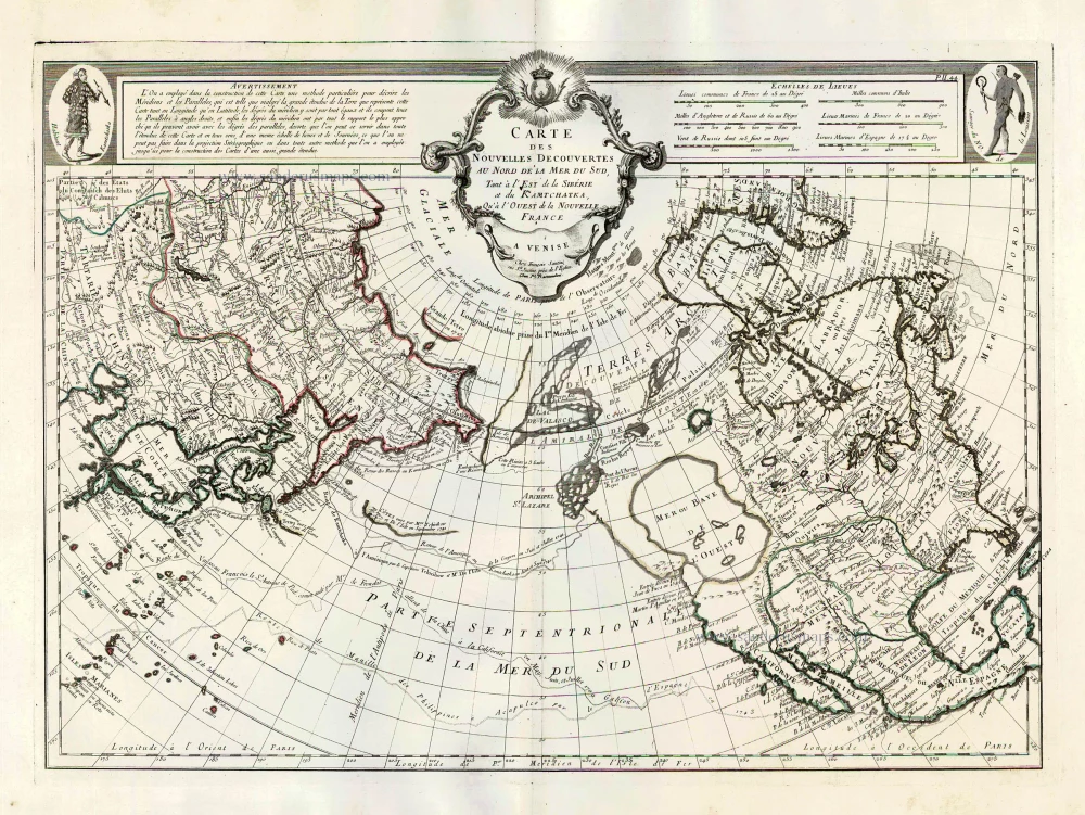
Carte des Nouvelles Decouvertes au Nord de la Mer du Sud, tant à l'Est de la Sibérie et du Kamtchatka, qu'à l'Ouest de la Nouvelle France. 1776-79
Pacific Ocean (North) by Francesco & Paolo Santini
[Item number: 26979]