Antique map of Sankt Polten by Braun & Hogenberg 1618
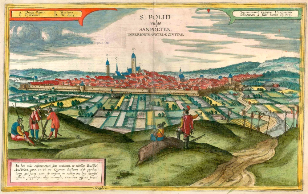


CAPTION: S. Polid, known in German as St Pölten, city in Lower Austria.
CARTOUCHE TOP RICHT: Procured by Georg Hoefnagel, drawn by his son Jakob in 1617.
CARTOUCHE BOTTOM LEFT: The conspiratorial and rebellious Austrian peasants met on this hill in '97 and '98. The leaders and instigators of this act of high treason were therefore martyred to death in various manners at this very place and, as a warning to others, crucified.
COMMENTARY BY BRAUN: "This city recently became known in an inglorious manner when the rabble and the peasants rose up against the authorities here in 1597. For after many of then had complained in secret about the heavy burden of taxes and compulsory labour, and noticed that many others felt the same way, they took up their weapons. [...] Then the Count of Thurn came with some horsemen and attacked the peasants at night, giving them such a fright that they scattered in all directions."
This view from a hill shows the well-fortified city dominated by the towers of the abbey belonging to the monastery of Augustinian Canons and of the town hall. On the foreground on the left are armed peasants and in the middle two nobles, one of whome is looking at the peasants while pointing to the bodies of the executed rebels hanging on gallows on the right. The Roman town of Aelium Cetium that once existed on the site of this historic city was granted city privileges in the 2nd century AD. A Benedictine monastery dedicated to St Hippolytus was erected here in the 8th century and converted into the above-mentioned monastery of Augustinian Canons around 1050. In 1159 St Pölten received a municipal charter. The city wall was built in the 13th century and provided protection from the Turks in 1529 and in 1683. (Taschen)
Braun G. & Hogenberg F. and the Civitates Orbis Terrarum.
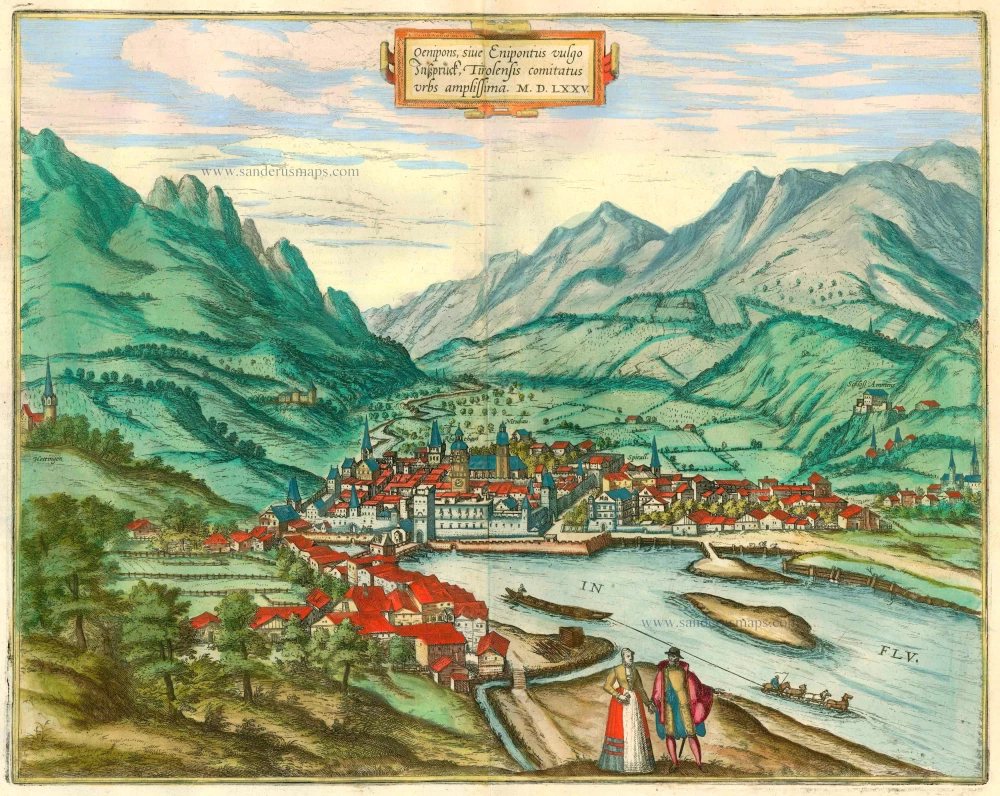
The Civitates Orbis Terrarum, or the "Braun & Hogenberg", is a six-volume town atlas and the most excellent book of town views and plans ever published: 363 engravings, sometimes beautifully coloured. It was one of the best-selling works in the last quarter of the 16th century. Georg Braun wrote the text accompanying the plans and views on the verso. Many plates were engraved after the original drawings of a professional artist, a professional artist, Joris Hoefnagel (1542-1600). The first volume was published in Latin in 1572, and the sixth in 1617. Frans Hogenberg created the tables for volumes I through IV, and Simon van den Neuwel made those for volumes V and VI. Other contributors were cartographers Daniel Freese and Heinrich Rantzau. Works by Jacob van Deventer, Sebastian Münster, and Johannes Stumpf were also used. Translations appeared in German and French.
Following the original publication of Volume 1 of the Civitates in 1572, seven further editions of 1575, 1577, 1582, 1588, 1593, 1599 and 1612 can be identified. Vol.2, first issued in 1575, was followed by further editions in 1597 and 1612. The subsequent volumes appeared in 1581, 1588, 1593, 1599 and 1606. The German translation of the first volume appeared from 1574 on, and the French edition from 1575 on.
Several printers were involved: Theodor Graminaeus, Heinrich von Aich, Gottfried von Kempen, Johannis Sinniger, Bertram Buchholtz and Peter von Brachel, who all worked in Cologne.
Georg Braun (1541-1622)
Georg Braun was born in Cologne in 1541. After his studies in Cologne, he entered the Jesuit Order as a novice. 1561, he obtained his bachelor's degree, and in 1562, he received his Magister Artium. Although he left the Jesuit Order, he studied theology, gaining a licentiate in theology.
Frans Hogenberg (1535-1590)
Frans Hogenberg was a Flemish and German painter, engraver, and mapmaker. He was born in Mechelen as the son of Nicolaas Hogenberg.
By the end of the 1560s, Frans Hogenberg was employed upon Abraham Ortelius's Theatrum Orbis Terrarum, published in 1570; he is named an engraver of numerous maps. In 1568, he was banned from Antwerp by the Duke of Alva and travelled to London, where he stayed a few years before emigrating to Cologne. He immediately embarked on his two most important works, the Civitates, published in 1572 and the Geschichtsblätter, which appeared in several series from 1569 until about 1587.
Thanks to large-scale projects like the Geschichtsblätter and the Civitates, Hogenberg's social circumstances improved with each passing year. He died as a wealthy man in Cologne in 1590.
S. Polid vulgo Sanpolten. Inferioris Austriae Civitas
Item Number: 23429 Authenticity Guarantee
Category: Antique maps > Europe > Austria
Antique map - bird's-eye view of Sankt Pölten by Braun and Hogenberg after G. Hoefnagel and son, 1617.
Key to four locations.
CAPTION: S. Polid, known in German as St Pölten, city in Lower Austria.
CARTOUCHE TOP RICHT: Procured by Georg Hoefnagel, drawn by his son Jakob in 1617.
CARTOUCHE BOTTOM LEFT: The conspiratorial and rebellious Austrian peasants met on this hill in '97 and '98. The leaders and instigators of this act of high treason were therefore martyred to death in various manners at this very place and, as a warning to others, crucified.
COMMENTARY BY BRAUN: "This city recently became known in an inglorious manner when the rabble and the peasants rose up against the authorities here in 1597. For after many of then had complained in secret about the heavy burden of taxes and compulsory labour, and noticed that many others felt the same way, they took up their weapons. [...] Then the Count of Thurn came with some horsemen and attacked the peasants at night, giving them such a fright that they scattered in all directions."
This view from a hill shows the well-fortified city dominated by the towers of the abbey belonging to the monastery of Augustinian Canons and of the town hall. On the foreground on the left are armed peasants and in the middle two nobles, one of whome is looking at the peasants while pointing to the bodies of the executed rebels hanging on gallows on the right. The Roman town of Aelium Cetium that once existed on the site of this historic city was granted city privileges in the 2nd century AD. A Benedictine monastery dedicated to St Hippolytus was erected here in the 8th century and converted into the above-mentioned monastery of Augustinian Canons around 1050. In 1159 St Pölten received a municipal charter. The city wall was built in the 13th century and provided protection from the Turks in 1529 and in 1683. (Taschen)
Date of the first edition: 1617
Date of this map: 1618
Copper engraving, printed on paper.
Size (not including margins): 30 x 48cm (11.7 x 18.6 inches)
Verso text: Latin
Condition: Excellent, superb old colour.
Condition Rating: A+
References: Van der Krogt 4, #4162; Fauser, #12502; Taschen, Br. Hog., p.459.
From: Theatri praecipuarum Totius Mundi Urbium Liber Sextus Anno MDCXVIII. (Van der Krogt 4, 41:1.6)
CAPTION: S. Polid, known in German as St Pölten, city in Lower Austria.
CARTOUCHE TOP RICHT: Procured by Georg Hoefnagel, drawn by his son Jakob in 1617.
CARTOUCHE BOTTOM LEFT: The conspiratorial and rebellious Austrian peasants met on this hill in '97 and '98. The leaders and instigators of this act of high treason were therefore martyred to death in various manners at this very place and, as a warning to others, crucified.
COMMENTARY BY BRAUN: "This city recently became known in an inglorious manner when the rabble and the peasants rose up against the authorities here in 1597. For after many of then had complained in secret about the heavy burden of taxes and compulsory labour, and noticed that many others felt the same way, they took up their weapons. [...] Then the Count of Thurn came with some horsemen and attacked the peasants at night, giving them such a fright that they scattered in all directions."
This view from a hill shows the well-fortified city dominated by the towers of the abbey belonging to the monastery of Augustinian Canons and of the town hall. On the foreground on the left are armed peasants and in the middle two nobles, one of whome is looking at the peasants while pointing to the bodies of the executed rebels hanging on gallows on the right. The Roman town of Aelium Cetium that once existed on the site of this historic city was granted city privileges in the 2nd century AD. A Benedictine monastery dedicated to St Hippolytus was erected here in the 8th century and converted into the above-mentioned monastery of Augustinian Canons around 1050. In 1159 St Pölten received a municipal charter. The city wall was built in the 13th century and provided protection from the Turks in 1529 and in 1683. (Taschen)
Braun G. & Hogenberg F. and the Civitates Orbis Terrarum.
The Civitates Orbis Terrarum, or the "Braun & Hogenberg", is a six-volume town atlas and the most excellent book of town views and plans ever published: 363 engravings, sometimes beautifully coloured. It was one of the best-selling works in the last quarter of the 16th century. Georg Braun wrote the text accompanying the plans and views on the verso. Many plates were engraved after the original drawings of a professional artist, a professional artist, Joris Hoefnagel (1542-1600). The first volume was published in Latin in 1572, and the sixth in 1617. Frans Hogenberg created the tables for volumes I through IV, and Simon van den Neuwel made those for volumes V and VI. Other contributors were cartographers Daniel Freese and Heinrich Rantzau. Works by Jacob van Deventer, Sebastian Münster, and Johannes Stumpf were also used. Translations appeared in German and French.
Following the original publication of Volume 1 of the Civitates in 1572, seven further editions of 1575, 1577, 1582, 1588, 1593, 1599 and 1612 can be identified. Vol.2, first issued in 1575, was followed by further editions in 1597 and 1612. The subsequent volumes appeared in 1581, 1588, 1593, 1599 and 1606. The German translation of the first volume appeared from 1574 on, and the French edition from 1575 on.
Several printers were involved: Theodor Graminaeus, Heinrich von Aich, Gottfried von Kempen, Johannis Sinniger, Bertram Buchholtz and Peter von Brachel, who all worked in Cologne.
Georg Braun (1541-1622)
Georg Braun was born in Cologne in 1541. After his studies in Cologne, he entered the Jesuit Order as a novice. 1561, he obtained his bachelor's degree, and in 1562, he received his Magister Artium. Although he left the Jesuit Order, he studied theology, gaining a licentiate in theology.
Frans Hogenberg (1535-1590)
Frans Hogenberg was a Flemish and German painter, engraver, and mapmaker. He was born in Mechelen as the son of Nicolaas Hogenberg.
By the end of the 1560s, Frans Hogenberg was employed upon Abraham Ortelius's Theatrum Orbis Terrarum, published in 1570; he is named an engraver of numerous maps. In 1568, he was banned from Antwerp by the Duke of Alva and travelled to London, where he stayed a few years before emigrating to Cologne. He immediately embarked on his two most important works, the Civitates, published in 1572 and the Geschichtsblätter, which appeared in several series from 1569 until about 1587.
Thanks to large-scale projects like the Geschichtsblätter and the Civitates, Hogenberg's social circumstances improved with each passing year. He died as a wealthy man in Cologne in 1590.