
Wien - Budapest, by Georg Braun & Frans Hogenberg. 1574
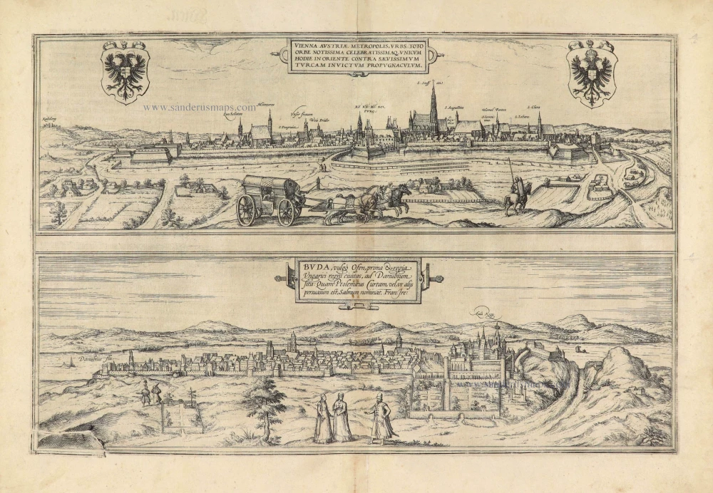
Old, antique bird’s-eye view of Wien and Budapest, by Georg Braun & Frans Hogenberg.
From later issues of the 1572 edition cracks are visible at te bottom left. To mask the crack, extra hatchuring was added in 1574. In 1577 the corner is repaired with a new piece of copper, in the border nails are visible, the new piece shows shrubs. Around 1600 this piece is gone.
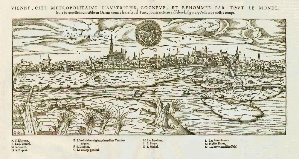
WIEN (Vienna)
TRANSLATION OF CARTOUCHE TEXT: Vienna, Austria's capital, city known and famed the whole world over, the only bulwark in the east unconquered by the ferocious Turks.
COMMENTARY BY BRAUN: "Vienna is an important city with impregnable walls that are so secure that Vienna can be called the protector of Christianity against the blood-thirsty Turks. Vienna's suburbs are large and magnificent. The churches constructed to the glory of God and the saints are very finely decorated and appear almost transparent, even though they are made of hard-hewn stone; noblest amongst them is St Stephen's. Vienna also has a very praiseworthy university, implanted here from Rome and Paris around 1337 by Emperor Frederick II."
Vienna is shown in a profile view from the west, with the Kahlenberg Hill on the far left. In the second half of the 12th century Vienna developed into the residence of the Duchy of Austria and a city wall was built around it at the beginning of the 13th century. In 1221 Vienna was granted a municipal charter, the university was founded in 1365 and the city became an episcopal see in 1469. In the 15th century trade declined, but the city's position as residence of the Holy Roman Empire was able to compensate the commercial losses. After the Siege of Vienna by the Ottoman army in 1529, the city's fortifications were rebuilt. The new fortifications, highly praised by Braun, resisted another Turkish siege before the Battle of Vienna in 1683. (Taschen)
BUDAPEST
TRANSLATION OF CARTOUCHE TEXT: Buda, commonly known as Ofen, capital and royal city of Hungary, on the Danube. According to Ptolemy it was called Curta, or as others believe, Salmum (F. Ireneus).
COMMENTARY BY BRAUN: " King Sigismund had magnificent houses built in Budapest, and within the citadel a palace in the ancient Roman style. [...] He also constructed a huge high palace in the town of Pest on the other side of the Danube, and he wanted to link both palaces with a bridge over the Danube. But envious Death prevented such an ambitious undertaking. [...] The city now lies in the hands of the Turks, who captured it in 1529, and much to the ruin and misery of the Christians who lived there." (Taschen)
Braun G. & Hogenberg F. and the Civitates Orbis Terrarum.
The Civitates Orbis Terrarum, or the "Braun & Hogenberg", is a six-volume town atlas and the most excellent book of town views and plans ever published: 363 engravings, sometimes beautifully coloured. It was one of the best-selling works in the last quarter of the 16th century. Georg Braun wrote the text accompanying the plans and views on the verso. Many plates were engraved after the original drawings of a professional artist, a professional artist, Joris Hoefnagel (1542-1600). The first volume was published in Latin in 1572, and the sixth in 1617. Frans Hogenberg created the tables for volumes I through IV, and Simon van den Neuwel made those for volumes V and VI. Other contributors were cartographers Daniel Freese and Heinrich Rantzau. Works by Jacob van Deventer, Sebastian Münster, and Johannes Stumpf were also used. Translations appeared in German and French.
Following the original publication of Volume 1 of the Civitates in 1572, seven further editions of 1575, 1577, 1582, 1588, 1593, 1599 and 1612 can be identified. Vol.2, first issued in 1575, was followed by further editions in 1597 and 1612. The subsequent volumes appeared in 1581, 1588, 1593, 1599 and 1606. The German translation of the first volume appeared from 1574 on, and the French edition from 1575 on.
Several printers were involved: Theodor Graminaeus, Heinrich von Aich, Gottfried von Kempen, Johannis Sinniger, Bertram Buchholtz and Peter von Brachel, who all worked in Cologne.
Georg Braun (1541-1622)
Georg Braun was born in Cologne in 1541. After his studies in Cologne, he entered the Jesuit Order as a novice. 1561, he obtained his bachelor's degree, and in 1562, he received his Magister Artium. Although he left the Jesuit Order, he studied theology, gaining a licentiate in theology.
Frans Hogenberg (1535-1590)
Frans Hogenberg was a Flemish and German painter, engraver, and mapmaker. He was born in Mechelen as the son of Nicolaas Hogenberg.
By the end of the 1560s, Frans Hogenberg was employed upon Abraham Ortelius's Theatrum Orbis Terrarum, published in 1570; he is named an engraver of numerous maps. In 1568, he was banned from Antwerp by the Duke of Alva and travelled to London, where he stayed a few years before emigrating to Cologne. He immediately embarked on his two most important works, the Civitates, published in 1572 and the Geschichtsblätter, which appeared in several series from 1569 until about 1587.
Thanks to large-scale projects like the Geschichtsblätter and the Civitates, Hogenberg's social circumstances improved with each passing year. He died as a wealthy man in Cologne in 1590.
Vienna Austriae Metropolis, Urbs Toto Orbe Notissima Celebratissimaq, Unicum Hodie in Oriente contra Saevissimum Turcam Invictum Propugnacvium [in set with:] Buda, vulgo Ofen, prima & regia Ungarici regni civitas, ...
Item Number: 28042 Authenticity Guarantee
Category: Antique maps > Europe > Austria
Title: Vienna Austriae Metropolis, Urbs Toto Orbe Notissima Celebratissimaq, Unicum Hodie in Oriente contra Saevissimum Turcam Invictum Propugnacvium [in set with:] Buda, vulgo Ofen, prima & regia Ungarici regni civitas, ...
Cum Privilegio.
Date of the first edition: 1572.
Date of this map: 1574.
Copper engraving, printed on paper.
Size (not including margins): 315 x 470mm (12.4 x 18.5 inches).
Verso: German text.
Condition: Some browning along centrefold, else very good.
Condition Rating: A.
References: References: Van der Krogt 4, 4835, State 1 (with cracks at the lower left cornerf) ; Taschen, Br. Hog. p.98; Fauser, #15355 & #2086
From: Beschreibung und Contrafactur der Vornembster Stät der Welt. Köln, Heinrich von Ach, 1574. (Van der Krogt 4, 41:2.1)
Old, antique bird’s-eye view of Wien and Budapest, by Georg Braun & Frans Hogenberg.
From later issues of the 1572 edition cracks are visible at te bottom left. To mask the crack, extra hatchuring was added in 1574. In 1577 the corner is repaired with a new piece of copper, in the border nails are visible, the new piece shows shrubs. Around 1600 this piece is gone.
WIEN (Vienna)
TRANSLATION OF CARTOUCHE TEXT: Vienna, Austria's capital, city known and famed the whole world over, the only bulwark in the east unconquered by the ferocious Turks.
COMMENTARY BY BRAUN: "Vienna is an important city with impregnable walls that are so secure that Vienna can be called the protector of Christianity against the blood-thirsty Turks. Vienna's suburbs are large and magnificent. The churches constructed to the glory of God and the saints are very finely decorated and appear almost transparent, even though they are made of hard-hewn stone; noblest amongst them is St Stephen's. Vienna also has a very praiseworthy university, implanted here from Rome and Paris around 1337 by Emperor Frederick II."
Vienna is shown in a profile view from the west, with the Kahlenberg Hill on the far left. In the second half of the 12th century Vienna developed into the residence of the Duchy of Austria and a city wall was built around it at the beginning of the 13th century. In 1221 Vienna was granted a municipal charter, the university was founded in 1365 and the city became an episcopal see in 1469. In the 15th century trade declined, but the city's position as residence of the Holy Roman Empire was able to compensate the commercial losses. After the Siege of Vienna by the Ottoman army in 1529, the city's fortifications were rebuilt. The new fortifications, highly praised by Braun, resisted another Turkish siege before the Battle of Vienna in 1683. (Taschen)
BUDAPEST
TRANSLATION OF CARTOUCHE TEXT: Buda, commonly known as Ofen, capital and royal city of Hungary, on the Danube. According to Ptolemy it was called Curta, or as others believe, Salmum (F. Ireneus).
COMMENTARY BY BRAUN: " King Sigismund had magnificent houses built in Budapest, and within the citadel a palace in the ancient Roman style. [...] He also constructed a huge high palace in the town of Pest on the other side of the Danube, and he wanted to link both palaces with a bridge over the Danube. But envious Death prevented such an ambitious undertaking. [...] The city now lies in the hands of the Turks, who captured it in 1529, and much to the ruin and misery of the Christians who lived there." (Taschen)
Braun G. & Hogenberg F. and the Civitates Orbis Terrarum.
The Civitates Orbis Terrarum, or the "Braun & Hogenberg", is a six-volume town atlas and the most excellent book of town views and plans ever published: 363 engravings, sometimes beautifully coloured. It was one of the best-selling works in the last quarter of the 16th century. Georg Braun wrote the text accompanying the plans and views on the verso. Many plates were engraved after the original drawings of a professional artist, a professional artist, Joris Hoefnagel (1542-1600). The first volume was published in Latin in 1572, and the sixth in 1617. Frans Hogenberg created the tables for volumes I through IV, and Simon van den Neuwel made those for volumes V and VI. Other contributors were cartographers Daniel Freese and Heinrich Rantzau. Works by Jacob van Deventer, Sebastian Münster, and Johannes Stumpf were also used. Translations appeared in German and French.
Following the original publication of Volume 1 of the Civitates in 1572, seven further editions of 1575, 1577, 1582, 1588, 1593, 1599 and 1612 can be identified. Vol.2, first issued in 1575, was followed by further editions in 1597 and 1612. The subsequent volumes appeared in 1581, 1588, 1593, 1599 and 1606. The German translation of the first volume appeared from 1574 on, and the French edition from 1575 on.
Several printers were involved: Theodor Graminaeus, Heinrich von Aich, Gottfried von Kempen, Johannis Sinniger, Bertram Buchholtz and Peter von Brachel, who all worked in Cologne.
Georg Braun (1541-1622)
Georg Braun was born in Cologne in 1541. After his studies in Cologne, he entered the Jesuit Order as a novice. 1561, he obtained his bachelor's degree, and in 1562, he received his Magister Artium. Although he left the Jesuit Order, he studied theology, gaining a licentiate in theology.
Frans Hogenberg (1535-1590)
Frans Hogenberg was a Flemish and German painter, engraver, and mapmaker. He was born in Mechelen as the son of Nicolaas Hogenberg.
By the end of the 1560s, Frans Hogenberg was employed upon Abraham Ortelius's Theatrum Orbis Terrarum, published in 1570; he is named an engraver of numerous maps. In 1568, he was banned from Antwerp by the Duke of Alva and travelled to London, where he stayed a few years before emigrating to Cologne. He immediately embarked on his two most important works, the Civitates, published in 1572 and the Geschichtsblätter, which appeared in several series from 1569 until about 1587.
Thanks to large-scale projects like the Geschichtsblätter and the Civitates, Hogenberg's social circumstances improved with each passing year. He died as a wealthy man in Cologne in 1590.
Related items
Vienna Austria. c. 1660
Wien, by D. Danckerts.
[Item number: 7049]
Prospect der kayserl. Resinetz Statt WIEN ... c.1716
Wien, by Bodenehr G.
[Item number: 13359]
Vienne, Capitale de l'Autriche. 1729
Wien ,by Vander Aa P.
[Item number: 19498]

Vienna Austriae Metropolis, Urbs Toto Orbe Notissima Celebratissimaq, Unicum Hodie in Oriente contra Saevissimum Turcam Invictum Propugnacvium 1572
Wien, by Georg Braun and Frans Hogenberg.
[Item number: 21881]
Vienne, cité metropolitaine d'Austriche, cogneue et renommée par tout le monde, seule forteresse invicible en Orient contre le très cruel Turc, poutraicte au vif selon la figure, qu'elle a de nostre temps. 1575
Vienna (Wien), by François de Belleforest.
[Item number: 27393]