
Ireland by Petrus Bertius 1618

Petrus Bertius (1565-1629)
Petrus Bertius, born at Beveren, Flanders in 1565, was related with Pieter van den Keere (Kaerius) and Jodocus Hondius. Both famous cartographers were brothers-in-law of Petrus Bertius. As a refugee, he settled in Amsterdam and, after finishing his studies, he became professor of mathematics and librarian at the University of Leiden. In 1618 he also became cosmographer and historiographer to Louis XIII of France and lived in Paris, where he died in 1629.
His enormous working power resulted in many geographical and theological works. He also contributed geographic materials to the works of Clüver and Herrera.
His fame among geographers was established by his text in the pocket atlas Tabularum Geographicarum and by his edition of Ptolemy’s Geographia.
The origin of the Tabularum Geographicum lies in the well-know miniature atlas Caert thresoor, published by Barent Langenes in 1598 in Middelburg. Bertius engraved 169 maps for this small but attractive atlas which was also sold for the first time in 1599 by Cornelis Claesz in Amsterdam. In 1600, Claesz published the pocket atlas with a Latin text composed by Petrus Bertius. From then on, new editions, often enlarged with new maps, regularly appeared, subsequently published by Cornellis Claesz, Jodocus Hondius, Johannes Janssonius and ultimately, in 1649, by Claes Jansz. Visscher.
Koeman divides this series of pocketbooks into two atlases: The Caert-thresoor, published by Langenes and Claesz., with five editions between 1598 and 1609; and the Tabularum Geographicarum Contractarum by Petrus Bertius with ten editions between 1600 and 1650.
Hibernia Septentr. in qua Ultonia Connatia. (in set with] Hibernia Austral. in qua Momonia Lagenia.
Item Number: 18205 Authenticity Guarantee
Category: Antique maps > Europe > British Isles
Two antique maps of Ireland (North & South), by Petrus Bertius.
Date of the first edition: 1618
Date of this map: 1618
Copper engraving, printed on paper.
Size (not including margins): 9.5 x 13.5cm (3.7 x 5.3 inches)
Verso text: French
Condition: Excellent.
Condition Rating: A+
References: Van der Krogt 3, 5901+5902:342.
From: La Geographie Recourcie de Pierre Bertius. Amsterdam, J. Hondius, 1618.
Petrus Bertius (1565-1629)
Petrus Bertius, born at Beveren, Flanders in 1565, was related with Pieter van den Keere (Kaerius) and Jodocus Hondius. Both famous cartographers were brothers-in-law of Petrus Bertius. As a refugee, he settled in Amsterdam and, after finishing his studies, he became professor of mathematics and librarian at the University of Leiden. In 1618 he also became cosmographer and historiographer to Louis XIII of France and lived in Paris, where he died in 1629.
His enormous working power resulted in many geographical and theological works. He also contributed geographic materials to the works of Clüver and Herrera.
His fame among geographers was established by his text in the pocket atlas Tabularum Geographicarum and by his edition of Ptolemy’s Geographia.
The origin of the Tabularum Geographicum lies in the well-know miniature atlas Caert thresoor, published by Barent Langenes in 1598 in Middelburg. Bertius engraved 169 maps for this small but attractive atlas which was also sold for the first time in 1599 by Cornelis Claesz in Amsterdam. In 1600, Claesz published the pocket atlas with a Latin text composed by Petrus Bertius. From then on, new editions, often enlarged with new maps, regularly appeared, subsequently published by Cornellis Claesz, Jodocus Hondius, Johannes Janssonius and ultimately, in 1649, by Claes Jansz. Visscher.
Koeman divides this series of pocketbooks into two atlases: The Caert-thresoor, published by Langenes and Claesz., with five editions between 1598 and 1609; and the Tabularum Geographicarum Contractarum by Petrus Bertius with ten editions between 1600 and 1650.
Related items
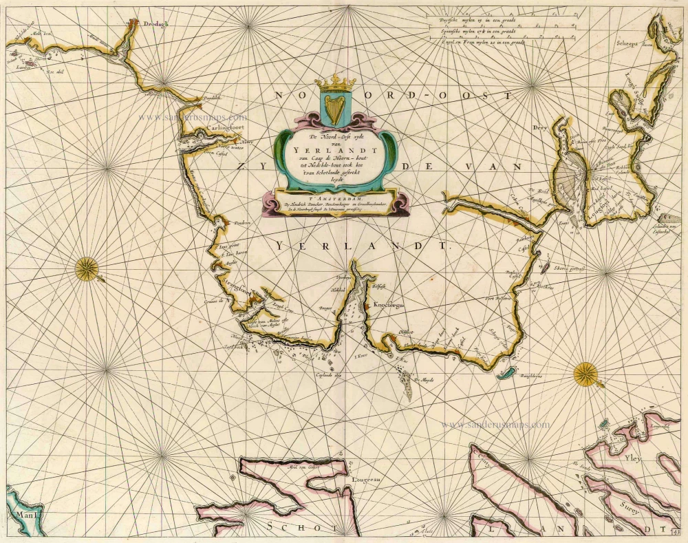
De Noord-Oost zyde van Yerlandt van Caap de Hoorn-hout tot Hedehde-hout oock hoe 't van Schotlandt gestrekt leydt 1686
Ireland, by Doncker H.
[Item number: 13644]
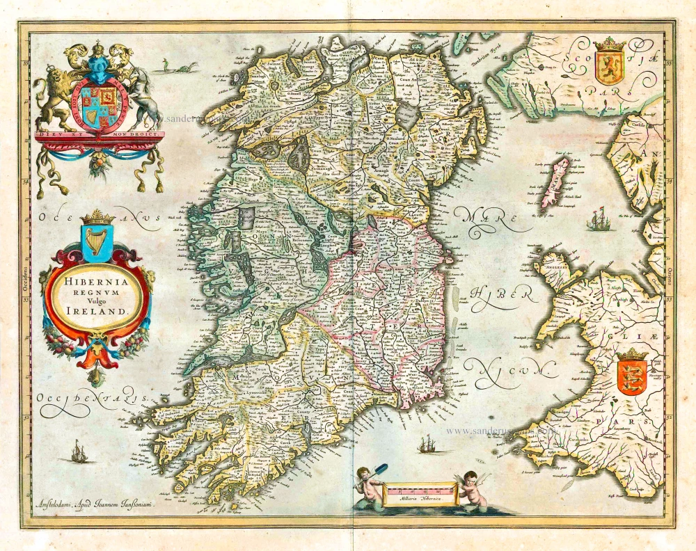
Hibernia Regnum Vulgo Ireland. 1641
Ireland by Joannes Janssonius
[Item number: 26258]
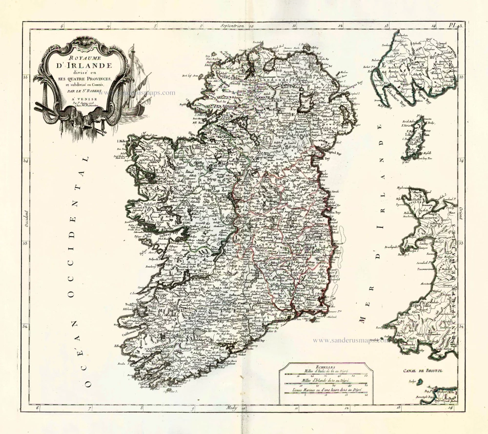
Royaume d'Irlande divisé en ses quatre provences, et subdivisé en Comtés. 1776-79
Ireland by Francesco & Paolo Santini
[Item number: 26962]