
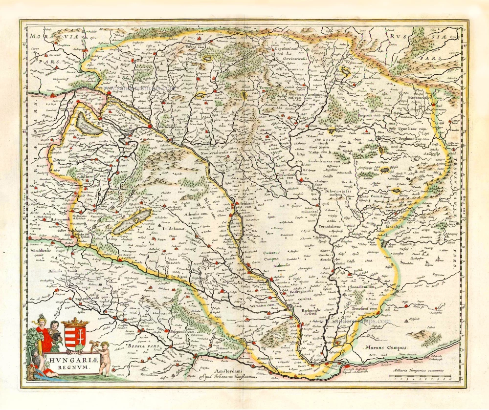
Hungary by Cornelis Claesz, published by Claes Jansz. Visscher. 1624
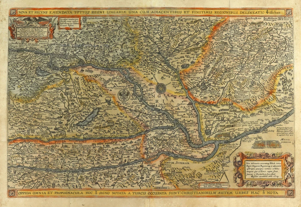
Scattered over the map are illustrations with captions related to historical events between Turks and Christians during 1409-1566.
The first state of this map was published in 1596 by Cornelis Claesz., the second state in 1619 by David de Meyne in 1619, the third state in 1620 by Pieter van den Keere. Thus, Van den Keere was the owner of Van Doetecum's copperplate for just a few years. In 1623, Claes Jansz Visscher had already purchased the copperplate from Van den Keere.
The Visscher Family
For nearly a century, the members of the Visscher family were essential art dealers and map publishers in Amsterdam.
Claes Jansz. Visscher, or N.J. Piscator (1587-1652)
Claes Jansz. Vischer bought a house in Amsterdam, 'de gulden Bors', on the crucial Kalverstraat and changed the name into "In de Visscher"; under this title, the shop was to flourish for many years.
He was famous for his engravings and etchings of Dutch landscapes and 'historical scenes', such as sieges, battles, etc. These 'historical scenes' were considered contemporary illustrated news items, especially e.g. that of 'the Eighty Years' War'.
For the publication of his first atlas, he bought copperplates of the atlas Germania Inferior by Pieter van den Keere (1623).
In 1649, he published an atlas entitled Tabularum Geographicarum Contractarum, containing the same maps as Langenes' Caert Thresoor, for which Visscher had only new title pages engraved.
Claes Jansz. Visscher died in 1652. His wife, Neeltjen Florisdr., had already died in 1640. They had seven children, four of whom were still alive at Claes Jansz.'s death. One was Nicolaes Visscher I, who was to continue his father's business.
Nicolaes Visscher I (1618-1679)
Nicolaes Visscher I partnered with his father, continued the business, and stayed on the Kalverstraat 'in de Visscher' till his death.
In about 1657, the first edition of his Atlas Contractus Orbis Terrarum appeared.
Between 1664 and 1677, several editions of his Atlas Contractus appeared without a printed index, for these atlases had no fixed contents but were composed according to the buyer's financial leaping pole.
In May 1664, Nicolaes Visscher was admitted as a member of the Booksellers' Guild of his town. In July 1677, he was granted a patent of the States of Holland and West-Friesland for printing and publishing maps and atlases for 15 years.
After this, he again published an Atlas Contractus with a printed index. At about the same time, he also brought out an Atlas Minor.
Nicolaes Visscher II (1649-1702)
Nicolaes Visscher II inherited the 'shop' from his father. To obtain a new privilege, he applied to the States of Holland and West-Friesland in 1682 for a patent for printing and publishing maps. This patent was granted to him the same year. He moved the firm to the Dam, but it kept the same signboard: "In de Visscher".
Around 1683, he published his first Atlas Minor with a printed index of 91 maps. In 1684, an atlas Germania Inferior appeared. Till 1697, he published another number of atlases. He used his grandfather's (Claes Jansz.) maps less often now and relied more and more on his own.
The wars waged at this time initiated the compilation of maps of the countries where the armies operated. Many war maps were included in the various editions of his Atlas Minor.
After Nicolaes's death, his wife, Elizabeth Verseyl, published all the war maps as an atlas under the title De Stoel des Oorlogs in de Wereld (The seat of war in the world).
The widow of Nicolaes Visscher II (?-1726)
His widow continued the business energetically, and by her hand, under the name of her deceased husband, numerous atlases appeared, e.g., several editions of the Atlas Minor, an Atlas Maior and De Stoel des Oorlogs. The shop enjoyed a high reputation due to the assortment's incredible variety. Not only 'Visscher' maps but also maps of other publishers were obtainable. With the death of Elizabeth Verseyl in 1726, the last descendant died of a great map- and atlas-publishing firm in Amsterdam.
Cornelis Claesz.
Printer and bookseller in Amsterdam, 1580-1609. He is famous for publishing maps, pilot guides, and atlases in the beginning period of the development of cartography in the northern Netherlands. He is noted for his co-operation with the cartographer Petrus Plancius and his editions of voyages. After 1590, the works of Lucas Jansz. He published Waghenaer, and in 1599, he acquired the publication rights of Barent Langenes’ Caert-thresoor.
Nova et Recens Emendata Totius Regni Ungariae una cum Adiacentibus et Finitimis Regionibus Delineatio.
Item Number: 28383 Authenticity Guarantee
Category: Antique maps > Europe > Central Europe
Old, antique map of Hungary, by Claes Jansz. Visscher.
Title: Nova et Recens Emendata Totius Regni Ungariae una cum Adiacentibus et Finitimis Regionibus Delineatio.
CJVisscher.
Vera delineatio accuratq[ue] Tabula totius Regni Un garici Regionumq[ue] ei adjacentiu aßcriptis prcipui nominis urbibus tempore quo à Turcis capta sunt Joannes à Duetechum Juni fecit.
CJVisscher excudebat anno 1624.
Cartographer: Cornelis Claesz..
Engraver: Joannes van Doetecum.
Date of the first edition: 1596 (state 1).
Date of this map: c. 1624.
Date on map: 1624.
Copper engraving, printed on paper.
Map size: 350 x 530mm (13.78 x 20.87 inches).
Sheet size: 415 x 555mm (16.34 x 21.85 inches).
Verso: Blank.
Condition: Original coloured, three vertical folds (as published) reinforced.
Condition Rating: A.
References: Szantai (Hungary), p. 152 Deutechum1d; Schilder 7, p. 403-408 15.7 state 4; Schilder 8, p. 552-553 #43; TNH Doet4, p. 186 #966 state IV
From: Composite Atlas, c. 1625.
Scattered over the map are illustrations with captions related to historical events between Turks and Christians during 1409-1566.
The first state of this map was published in 1596 by Cornelis Claesz., the second state in 1619 by David de Meyne in 1619, the third state in 1620 by Pieter van den Keere. Thus, Van den Keere was the owner of Van Doetecum's copperplate for just a few years. In 1623, Claes Jansz Visscher had already purchased the copperplate from Van den Keere.
The Visscher Family
For nearly a century, the members of the Visscher family were essential art dealers and map publishers in Amsterdam.
Claes Jansz. Visscher, or N.J. Piscator (1587-1652)
Claes Jansz. Vischer bought a house in Amsterdam, 'de gulden Bors', on the crucial Kalverstraat and changed the name into "In de Visscher"; under this title, the shop was to flourish for many years.
He was famous for his engravings and etchings of Dutch landscapes and 'historical scenes', such as sieges, battles, etc. These 'historical scenes' were considered contemporary illustrated news items, especially e.g. that of 'the Eighty Years' War'.
For the publication of his first atlas, he bought copperplates of the atlas Germania Inferior by Pieter van den Keere (1623).
In 1649, he published an atlas entitled Tabularum Geographicarum Contractarum, containing the same maps as Langenes' Caert Thresoor, for which Visscher had only new title pages engraved.
Claes Jansz. Visscher died in 1652. His wife, Neeltjen Florisdr., had already died in 1640. They had seven children, four of whom were still alive at Claes Jansz.'s death. One was Nicolaes Visscher I, who was to continue his father's business.
Nicolaes Visscher I (1618-1679)
Nicolaes Visscher I partnered with his father, continued the business, and stayed on the Kalverstraat 'in de Visscher' till his death.
In about 1657, the first edition of his Atlas Contractus Orbis Terrarum appeared.
Between 1664 and 1677, several editions of his Atlas Contractus appeared without a printed index, for these atlases had no fixed contents but were composed according to the buyer's financial leaping pole.
In May 1664, Nicolaes Visscher was admitted as a member of the Booksellers' Guild of his town. In July 1677, he was granted a patent of the States of Holland and West-Friesland for printing and publishing maps and atlases for 15 years.
After this, he again published an Atlas Contractus with a printed index. At about the same time, he also brought out an Atlas Minor.
Nicolaes Visscher II (1649-1702)
Nicolaes Visscher II inherited the 'shop' from his father. To obtain a new privilege, he applied to the States of Holland and West-Friesland in 1682 for a patent for printing and publishing maps. This patent was granted to him the same year. He moved the firm to the Dam, but it kept the same signboard: "In de Visscher".
Around 1683, he published his first Atlas Minor with a printed index of 91 maps. In 1684, an atlas Germania Inferior appeared. Till 1697, he published another number of atlases. He used his grandfather's (Claes Jansz.) maps less often now and relied more and more on his own.
The wars waged at this time initiated the compilation of maps of the countries where the armies operated. Many war maps were included in the various editions of his Atlas Minor.
After Nicolaes's death, his wife, Elizabeth Verseyl, published all the war maps as an atlas under the title De Stoel des Oorlogs in de Wereld (The seat of war in the world).
The widow of Nicolaes Visscher II (?-1726)
His widow continued the business energetically, and by her hand, under the name of her deceased husband, numerous atlases appeared, e.g., several editions of the Atlas Minor, an Atlas Maior and De Stoel des Oorlogs. The shop enjoyed a high reputation due to the assortment's incredible variety. Not only 'Visscher' maps but also maps of other publishers were obtainable. With the death of Elizabeth Verseyl in 1726, the last descendant died of a great map- and atlas-publishing firm in Amsterdam.
Cornelis Claesz.
Printer and bookseller in Amsterdam, 1580-1609. He is famous for publishing maps, pilot guides, and atlases in the beginning period of the development of cartography in the northern Netherlands. He is noted for his co-operation with the cartographer Petrus Plancius and his editions of voyages. After 1590, the works of Lucas Jansz. He published Waghenaer, and in 1599, he acquired the publication rights of Barent Langenes’ Caert-thresoor.
Related items

Very rare
Hungaria Regnum. 16th cent.
Hungary by an unknown mapmaker.
[Item number: 24501]
Hungaria 1623
Hungary, by Gerard Mercator.
[Item number: 24948]
Poloniae et Ungariae Nova Descriptio. 1552
Poland and Hungary, by S. Münster.
[Item number: 25905]

Le Royaume de Hongrie et des Pays qui en dependoient autrefois. 1730
Balkans by Guillaume Delisle - Covens & Mortier
[Item number: 25910]
La Hongrie, Suivant les Nouvelles Observations de Mess.rs de l'Academie Royale des Sciences, 1713
Hungary, by Pieter van der Aa.
[Item number: 26043]
Hungariae Regnum. 1666
Hungary, by Johannes Janssonius.
[Item number: 27028]
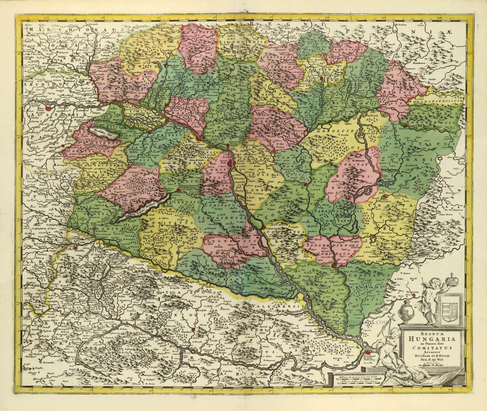
Regnum Hungariae in Omnes suos Comitatus Accurate Divisum et Editum. 1710-21
Hungary by Frederik de Wit, published by Covens & Mortier.
[Item number: 28326]