
Marseille, by Georg Braun and Frans Hogenberg. 1575
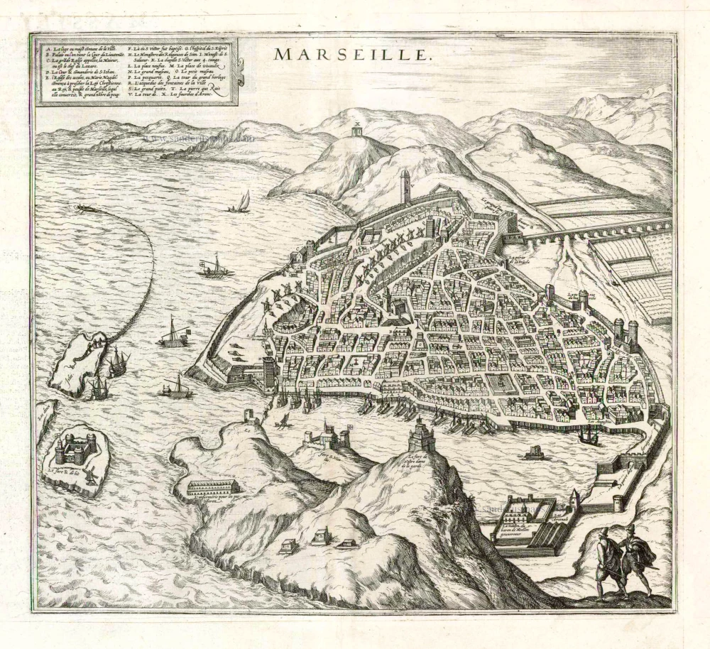
COMMENTARY BY BRAUN (on verso): "Marseilles, called Massalia in Greek, Massilia in Latin, is a rich city in Provence in France. It was built by the Greeks, which is why the inhabitants are endowed with good manners and admire and practise the liberal arts. The city allied itself with the Romans, who, however, corrupted and plundered it as a result of their pride and insatiable greed. [...] Although Marseilles can be highly praised for a variety of reasons, [...] Marseilles deserves eternal praise because it was one of the first cities to accept the redeeming faith directly after the birth of Christ."
The engraving shows Marseilles from the southeast, with a part of the Frioul Archipelago on the far left, the two main islands of Pomègues and Ratonneau, and the small island of If. The fortress on If owes its fame mainly to the novel The Count of Monte Cristo by Alexandre Dumas. The fortress of Notre-Dame de la Garde, built in 1525, is perched on a high limestone bluff in the foreground. This was replaced 300 years later by a neo-Byzantine church of the same name, which is the landmark of present-day Marseilles. To the left of it are the facing fortresses of Saint-Nicolas and Saint-Jean. After its founding by the Greeks around 600 BC. Marseilles became one of the most important Greek colonies due to its favourable location. In 125 BC the city asked the Roman Empire for help in defending itself against Gallic tribes, which led to its annexation by the Romans. Catacombs and writings by martryrs document the importance of Christianity in Marseilles as early as the 1st century AD; the Diocese of Marseilles also goes back to this time. (Taschen)
Braun G. & Hogenberg F. and the Civitates Orbis Terrarum.
The Civitates Orbis Terrarum, or the "Braun & Hogenberg", is a six-volume town atlas and the most excellent book of town views and plans ever published: 363 engravings, sometimes beautifully coloured. It was one of the best-selling works in the last quarter of the 16th century. Georg Braun wrote the text accompanying the plans and views on the verso. Many plates were engraved after the original drawings of a professional artist, a professional artist, Joris Hoefnagel (1542-1600). The first volume was published in Latin in 1572, and the sixth in 1617. Frans Hogenberg created the tables for volumes I through IV, and Simon van den Neuwel made those for volumes V and VI. Other contributors were cartographers Daniel Freese and Heinrich Rantzau. Works by Jacob van Deventer, Sebastian Münster, and Johannes Stumpf were also used. Translations appeared in German and French.
Following the original publication of Volume 1 of the Civitates in 1572, seven further editions of 1575, 1577, 1582, 1588, 1593, 1599 and 1612 can be identified. Vol.2, first issued in 1575, was followed by further editions in 1597 and 1612. The subsequent volumes appeared in 1581, 1588, 1593, 1599 and 1606. The German translation of the first volume appeared from 1574 on, and the French edition from 1575 on.
Several printers were involved: Theodor Graminaeus, Heinrich von Aich, Gottfried von Kempen, Johannis Sinniger, Bertram Buchholtz and Peter von Brachel, who all worked in Cologne.
Georg Braun (1541-1622)
Georg Braun was born in Cologne in 1541. After his studies in Cologne, he entered the Jesuit Order as a novice. 1561, he obtained his bachelor's degree, and in 1562, he received his Magister Artium. Although he left the Jesuit Order, he studied theology, gaining a licentiate in theology.
Frans Hogenberg (1535-1590)
Frans Hogenberg was a Flemish and German painter, engraver, and mapmaker. He was born in Mechelen as the son of Nicolaas Hogenberg.
By the end of the 1560s, Frans Hogenberg was employed upon Abraham Ortelius's Theatrum Orbis Terrarum, published in 1570; he is named an engraver of numerous maps. In 1568, he was banned from Antwerp by the Duke of Alva and travelled to London, where he stayed a few years before emigrating to Cologne. He immediately embarked on his two most important works, the Civitates, published in 1572 and the Geschichtsblätter, which appeared in several series from 1569 until about 1587.
Thanks to large-scale projects like the Geschichtsblätter and the Civitates, Hogenberg's social circumstances improved with each passing year. He died as a wealthy man in Cologne in 1590.
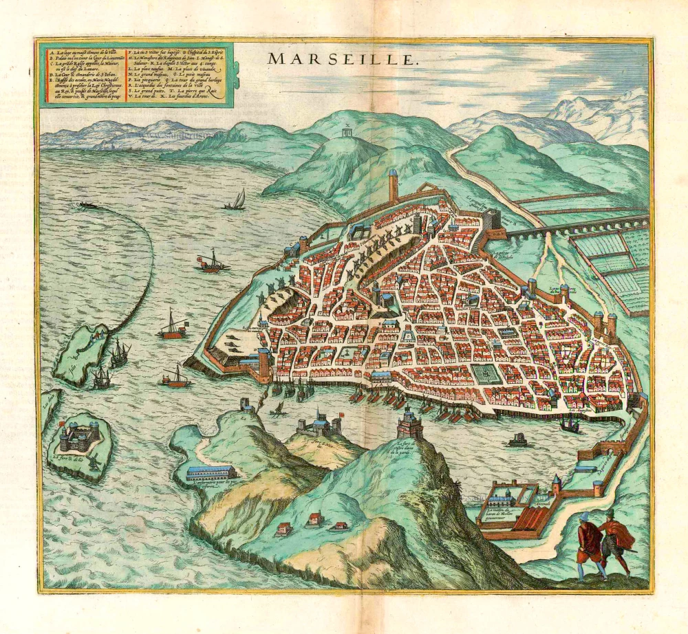
Marseille.
Item Number: 6936 Authenticity Guarantee
Category: Antique maps > Europe > France
Old, antique bird’s-eye view plan of Marseille, by Georg Braun & Frans Hogenberg.
Title: Marseille.
Date of the first edition: 1575.
Date of this map: 1575.
Copper engraving, printed on paper.
Size (not including margins): 320 x 360mm (12.6 x 14.17 inches).
Verso: Latin text.
Condition: Uncoloured, excellent.
Condition Rating: A+
References: Van der Krogt 4 - #2634; Taschen, Br. Hog. - p. 145
From: Civitates Orbis Terrarum, ... Part 2: De Praecipuis, Totius Universi Urbibus, Liber Secundus. Köln, Gottfried von Kempen, 1575. (Van der Krogt 4, 41:1.2)
COMMENTARY BY BRAUN (on verso): "Marseilles, called Massalia in Greek, Massilia in Latin, is a rich city in Provence in France. It was built by the Greeks, which is why the inhabitants are endowed with good manners and admire and practise the liberal arts. The city allied itself with the Romans, who, however, corrupted and plundered it as a result of their pride and insatiable greed. [...] Although Marseilles can be highly praised for a variety of reasons, [...] Marseilles deserves eternal praise because it was one of the first cities to accept the redeeming faith directly after the birth of Christ."
The engraving shows Marseilles from the southeast, with a part of the Frioul Archipelago on the far left, the two main islands of Pomègues and Ratonneau, and the small island of If. The fortress on If owes its fame mainly to the novel The Count of Monte Cristo by Alexandre Dumas. The fortress of Notre-Dame de la Garde, built in 1525, is perched on a high limestone bluff in the foreground. This was replaced 300 years later by a neo-Byzantine church of the same name, which is the landmark of present-day Marseilles. To the left of it are the facing fortresses of Saint-Nicolas and Saint-Jean. After its founding by the Greeks around 600 BC. Marseilles became one of the most important Greek colonies due to its favourable location. In 125 BC the city asked the Roman Empire for help in defending itself against Gallic tribes, which led to its annexation by the Romans. Catacombs and writings by martryrs document the importance of Christianity in Marseilles as early as the 1st century AD; the Diocese of Marseilles also goes back to this time. (Taschen)
Braun G. & Hogenberg F. and the Civitates Orbis Terrarum.
The Civitates Orbis Terrarum, or the "Braun & Hogenberg", is a six-volume town atlas and the most excellent book of town views and plans ever published: 363 engravings, sometimes beautifully coloured. It was one of the best-selling works in the last quarter of the 16th century. Georg Braun wrote the text accompanying the plans and views on the verso. Many plates were engraved after the original drawings of a professional artist, a professional artist, Joris Hoefnagel (1542-1600). The first volume was published in Latin in 1572, and the sixth in 1617. Frans Hogenberg created the tables for volumes I through IV, and Simon van den Neuwel made those for volumes V and VI. Other contributors were cartographers Daniel Freese and Heinrich Rantzau. Works by Jacob van Deventer, Sebastian Münster, and Johannes Stumpf were also used. Translations appeared in German and French.
Following the original publication of Volume 1 of the Civitates in 1572, seven further editions of 1575, 1577, 1582, 1588, 1593, 1599 and 1612 can be identified. Vol.2, first issued in 1575, was followed by further editions in 1597 and 1612. The subsequent volumes appeared in 1581, 1588, 1593, 1599 and 1606. The German translation of the first volume appeared from 1574 on, and the French edition from 1575 on.
Several printers were involved: Theodor Graminaeus, Heinrich von Aich, Gottfried von Kempen, Johannis Sinniger, Bertram Buchholtz and Peter von Brachel, who all worked in Cologne.
Georg Braun (1541-1622)
Georg Braun was born in Cologne in 1541. After his studies in Cologne, he entered the Jesuit Order as a novice. 1561, he obtained his bachelor's degree, and in 1562, he received his Magister Artium. Although he left the Jesuit Order, he studied theology, gaining a licentiate in theology.
Frans Hogenberg (1535-1590)
Frans Hogenberg was a Flemish and German painter, engraver, and mapmaker. He was born in Mechelen as the son of Nicolaas Hogenberg.
By the end of the 1560s, Frans Hogenberg was employed upon Abraham Ortelius's Theatrum Orbis Terrarum, published in 1570; he is named an engraver of numerous maps. In 1568, he was banned from Antwerp by the Duke of Alva and travelled to London, where he stayed a few years before emigrating to Cologne. He immediately embarked on his two most important works, the Civitates, published in 1572 and the Geschichtsblätter, which appeared in several series from 1569 until about 1587.
Thanks to large-scale projects like the Geschichtsblätter and the Civitates, Hogenberg's social circumstances improved with each passing year. He died as a wealthy man in Cologne in 1590.
Related items
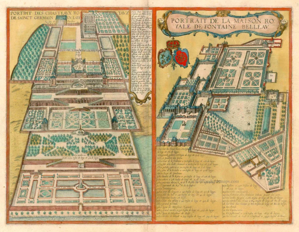
Portrait des Chasteaux Royaux de Sainct Germain en Laye [on sheet with] Portrait de la Maison Royale de Fontaine Belleau. c. 1625
Saint-Germain-en-Laye and Fontainebleau, by Georg Braun and Frans Hogenberg.
[Item number: 16387]
Marseille. 1576
Marseille, by Georg Braun and Frans Hogenberg.
[Item number: 25583]
Rare
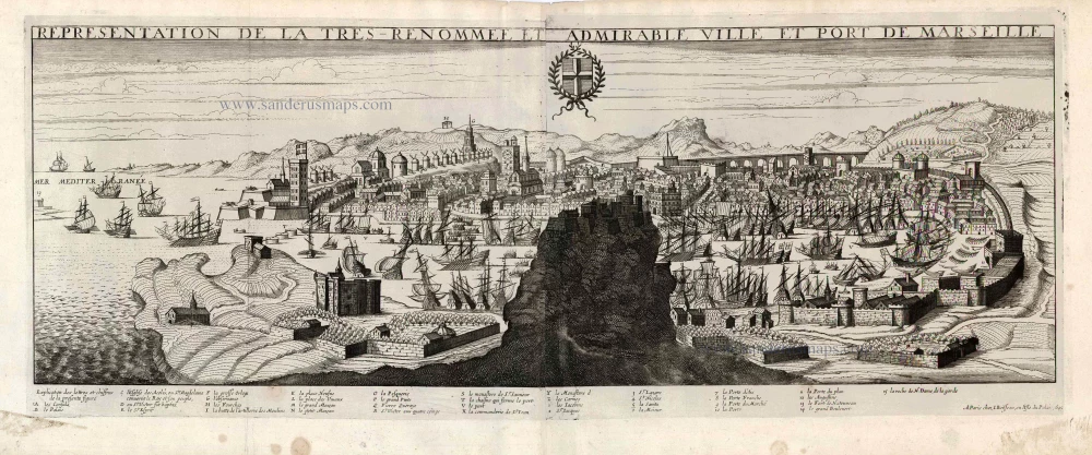
Representation de la Tres Renommee et Admirable Ville et Port de Marseille. 1648
Marseille, by J. Boisseau.
[Item number: 25601]