
Eutin - Tønder by Georg Braun & Frans Hogenberg 1596
The item displayed on this page has been sold. However, we have a similar map in stock:
Eutin - Tønder by Braun & Hogenberg c. 1610
Oitinense oppidulum et arx Episcopi Lubecensis ...
[Item number: 24595]
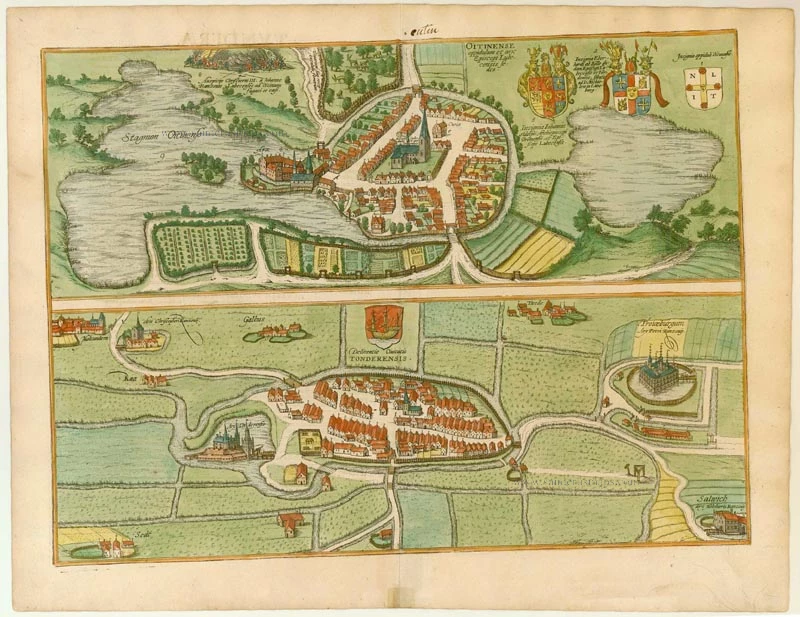
![Oitinense oppidulum et arx Episcopi Lubecensis sedes [on sheet with] Delineatio Civitatis Tonderensis](https://sanderusmaps.com/assets/RESIZED/thumb_m24595.jpg)
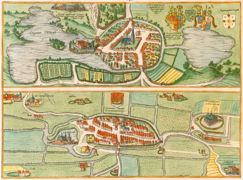


EUTIN
CAPTION: Eutin, a small town with a castle, seat of the bishop of Lübeck.
COMMENTARY BY BRAUN (on verso): "The little town with the castle, in which the bishops of Lübeck now normally hold court, was built by Adolph II, Count of Holstein, Wagrien and Schauenburg, by whom the town was also granted its coat of arms and its charter. At the wish of Henry the Lion, around the year 1159 Adolph II made a gift of the castle together with 300 morgens of land to the bishopric of Oldenburg."
The bird's-eye view from the north illustrates how Eutin, which had no ring wall, drew it protection solely from the two lakes surrounding it, namely the Greater and the Lesser Lake Eutin. At the centre of the town, which is here depicted stereotypically, stands the church of St Michaell. In 1156 Eutin passed to the diocese of Oldenburg and in 1300 became the episcopal see of the prince-bishops of Lübeck. The bishop's palace lies on a spit of land on the northeast side of the town (4). An episode from the battle over this palace is shown above: after the death of Frederick I of Denmark on 10 April 1533, the Lübeck bishops occupied Holstein; one year later, however, they were driven back by the troops of Christian III under his commander-in-chief Johann Rantzau, the father of Heinrich Rantzau, who was, in turn, one of Georg Braun's sources. From 1586 the Dukes of Schleswig-Holstein-Gottorp supplied the prince-bishops of Lübeck and came into possession of Eutin. As a result, frequent alterations were carried out on the palace, which had to be completely rebuilt after a devastating fire in 1689.
TØNDER
COMMENTARY BY BRAUN (on verso): "Tønder is a delightful little town in the Duchy of Schleswig in a fertile location with both arable land and pastures. Its convenience for shipping is adequately demonstrated by the coat of arms bearing a boat. But, unfortunately, in 1532, a storm caused the water to rise three and a half feet right up to the main church, in memory of which people have now carved crosses everywhere into the walls."
The plate shows a bird's-eye view of Tønder from the east, with the Vida River flowing around it. Documented as a port since 1017, the small town is surrounded by moated castles. On the left lies Tønder castle (Arx Tonderensis), and in the top left-hand corner the Møgeltøndernhus, documented since 1233, which lies 7 km west of Tønder near the settlement of Møgeltønder and was inhabited by Christoffer Rantzau. North of Tønder lies the magnificent moated castle of Troyburg, the residence of Peter Rantzau, beneath which is Sollwig castle, home to the Danish governor of Holstein-Gottorp, Melchior Rantzau. After the foundation of Dominican and Franciscan monasteries, the town grew and was granted a municipal charter in 1243. As one of the few ports on the west coast of Schleswig, it profited economically from its geographical position, even if this also contained disadvantages: the town was visited frequently by floods. Tønder, which lies 4 km from the border with Germany, formed part of the German Empire until 1920 when it passed to Denmark.
Braun G. & Hogenberg F. and the Civitates Orbis Terrarum.
The Civitates Orbis Terrarum, or the "Braun & Hogenberg", is a six-volume town atlas and the most excellent book of town views and plans ever published: 363 engravings, sometimes beautifully coloured. It was one of the best-selling works in the last quarter of the 16th century. Georg Braun wrote the text accompanying the plans and views on the verso. Many plates were engraved after the original drawings of a professional artist, a professional artist, Joris Hoefnagel (1542-1600). The first volume was published in Latin in 1572, and the sixth in 1617. Frans Hogenberg created the tables for volumes I through IV, and Simon van den Neuwel made those for volumes V and VI. Other contributors were cartographers Daniel Freese and Heinrich Rantzau. Works by Jacob van Deventer, Sebastian Münster, and Johannes Stumpf were also used. Translations appeared in German and French.
Following the original publication of Volume 1 of the Civitates in 1572, seven further editions of 1575, 1577, 1582, 1588, 1593, 1599 and 1612 can be identified. Vol.2, first issued in 1575, was followed by further editions in 1597 and 1612. The subsequent volumes appeared in 1581, 1588, 1593, 1599 and 1606. The German translation of the first volume appeared from 1574 on, and the French edition from 1575 on.
Several printers were involved: Theodor Graminaeus, Heinrich von Aich, Gottfried von Kempen, Johannis Sinniger, Bertram Buchholtz and Peter von Brachel, who all worked in Cologne.
Georg Braun (1541-1622)
Georg Braun was born in Cologne in 1541. After his studies in Cologne, he entered the Jesuit Order as a novice. 1561, he obtained his bachelor's degree, and in 1562, he received his Magister Artium. Although he left the Jesuit Order, he studied theology, gaining a licentiate in theology.
Frans Hogenberg (1535-1590)
Frans Hogenberg was a Flemish and German painter, engraver, and mapmaker. He was born in Mechelen as the son of Nicolaas Hogenberg.
By the end of the 1560s, Frans Hogenberg was employed upon Abraham Ortelius's Theatrum Orbis Terrarum, published in 1570; he is named an engraver of numerous maps. In 1568, he was banned from Antwerp by the Duke of Alva and travelled to London, where he stayed a few years before emigrating to Cologne. He immediately embarked on his two most important works, the Civitates, published in 1572 and the Geschichtsblätter, which appeared in several series from 1569 until about 1587.
Thanks to large-scale projects like the Geschichtsblätter and the Civitates, Hogenberg's social circumstances improved with each passing year. He died as a wealthy man in Cologne in 1590.
Oitinense oppidulum et arx Episcopi Lubecensis sedes [on sheet with] Delineatio Civitatis Tonderensis.
Item Number: 22086 Authenticity Guarantee
Category: Antique maps > Europe > Germany - Cities
Antique map with two bird's-eye plans by Braun and Hogenberg: Tønder (Denmark) and Eutin (Germany).
Title: Oitinense oppidulum et arx Episcopi Lubecensis sedes [on sheet with] Delineatio Civitatis Tonderensis.
Date of the first edition: 1596.
Date of this map: 1596.
Copper engraving, printed on paper.
Size (not including margins): 325 x 475mm (12.8 x 18.7 inches).
Verso: Latin text.
Condition: Original coloured, excellent.
Condition Rating: A+.
References: Van der Krogt 4, 1286; Taschen, Braun and Hogenberg, p.385
From: Civitates Orbis Terrarum, ... Part 5. Köln, 1596-1640.
EUTIN
CAPTION: Eutin, a small town with a castle, seat of the bishop of Lübeck.
COMMENTARY BY BRAUN (on verso): "The little town with the castle, in which the bishops of Lübeck now normally hold court, was built by Adolph II, Count of Holstein, Wagrien and Schauenburg, by whom the town was also granted its coat of arms and its charter. At the wish of Henry the Lion, around the year 1159 Adolph II made a gift of the castle together with 300 morgens of land to the bishopric of Oldenburg."
The bird's-eye view from the north illustrates how Eutin, which had no ring wall, drew it protection solely from the two lakes surrounding it, namely the Greater and the Lesser Lake Eutin. At the centre of the town, which is here depicted stereotypically, stands the church of St Michaell. In 1156 Eutin passed to the diocese of Oldenburg and in 1300 became the episcopal see of the prince-bishops of Lübeck. The bishop's palace lies on a spit of land on the northeast side of the town (4). An episode from the battle over this palace is shown above: after the death of Frederick I of Denmark on 10 April 1533, the Lübeck bishops occupied Holstein; one year later, however, they were driven back by the troops of Christian III under his commander-in-chief Johann Rantzau, the father of Heinrich Rantzau, who was, in turn, one of Georg Braun's sources. From 1586 the Dukes of Schleswig-Holstein-Gottorp supplied the prince-bishops of Lübeck and came into possession of Eutin. As a result, frequent alterations were carried out on the palace, which had to be completely rebuilt after a devastating fire in 1689.
TØNDER
COMMENTARY BY BRAUN (on verso): "Tønder is a delightful little town in the Duchy of Schleswig in a fertile location with both arable land and pastures. Its convenience for shipping is adequately demonstrated by the coat of arms bearing a boat. But, unfortunately, in 1532, a storm caused the water to rise three and a half feet right up to the main church, in memory of which people have now carved crosses everywhere into the walls."
The plate shows a bird's-eye view of Tønder from the east, with the Vida River flowing around it. Documented as a port since 1017, the small town is surrounded by moated castles. On the left lies Tønder castle (Arx Tonderensis), and in the top left-hand corner the Møgeltøndernhus, documented since 1233, which lies 7 km west of Tønder near the settlement of Møgeltønder and was inhabited by Christoffer Rantzau. North of Tønder lies the magnificent moated castle of Troyburg, the residence of Peter Rantzau, beneath which is Sollwig castle, home to the Danish governor of Holstein-Gottorp, Melchior Rantzau. After the foundation of Dominican and Franciscan monasteries, the town grew and was granted a municipal charter in 1243. As one of the few ports on the west coast of Schleswig, it profited economically from its geographical position, even if this also contained disadvantages: the town was visited frequently by floods. Tønder, which lies 4 km from the border with Germany, formed part of the German Empire until 1920 when it passed to Denmark.
Braun G. & Hogenberg F. and the Civitates Orbis Terrarum.
The Civitates Orbis Terrarum, or the "Braun & Hogenberg", is a six-volume town atlas and the most excellent book of town views and plans ever published: 363 engravings, sometimes beautifully coloured. It was one of the best-selling works in the last quarter of the 16th century. Georg Braun wrote the text accompanying the plans and views on the verso. Many plates were engraved after the original drawings of a professional artist, a professional artist, Joris Hoefnagel (1542-1600). The first volume was published in Latin in 1572, and the sixth in 1617. Frans Hogenberg created the tables for volumes I through IV, and Simon van den Neuwel made those for volumes V and VI. Other contributors were cartographers Daniel Freese and Heinrich Rantzau. Works by Jacob van Deventer, Sebastian Münster, and Johannes Stumpf were also used. Translations appeared in German and French.
Following the original publication of Volume 1 of the Civitates in 1572, seven further editions of 1575, 1577, 1582, 1588, 1593, 1599 and 1612 can be identified. Vol.2, first issued in 1575, was followed by further editions in 1597 and 1612. The subsequent volumes appeared in 1581, 1588, 1593, 1599 and 1606. The German translation of the first volume appeared from 1574 on, and the French edition from 1575 on.
Several printers were involved: Theodor Graminaeus, Heinrich von Aich, Gottfried von Kempen, Johannis Sinniger, Bertram Buchholtz and Peter von Brachel, who all worked in Cologne.
Georg Braun (1541-1622)
Georg Braun was born in Cologne in 1541. After his studies in Cologne, he entered the Jesuit Order as a novice. 1561, he obtained his bachelor's degree, and in 1562, he received his Magister Artium. Although he left the Jesuit Order, he studied theology, gaining a licentiate in theology.
Frans Hogenberg (1535-1590)
Frans Hogenberg was a Flemish and German painter, engraver, and mapmaker. He was born in Mechelen as the son of Nicolaas Hogenberg.
By the end of the 1560s, Frans Hogenberg was employed upon Abraham Ortelius's Theatrum Orbis Terrarum, published in 1570; he is named an engraver of numerous maps. In 1568, he was banned from Antwerp by the Duke of Alva and travelled to London, where he stayed a few years before emigrating to Cologne. He immediately embarked on his two most important works, the Civitates, published in 1572 and the Geschichtsblätter, which appeared in several series from 1569 until about 1587.
Thanks to large-scale projects like the Geschichtsblätter and the Civitates, Hogenberg's social circumstances improved with each passing year. He died as a wealthy man in Cologne in 1590.
Related items
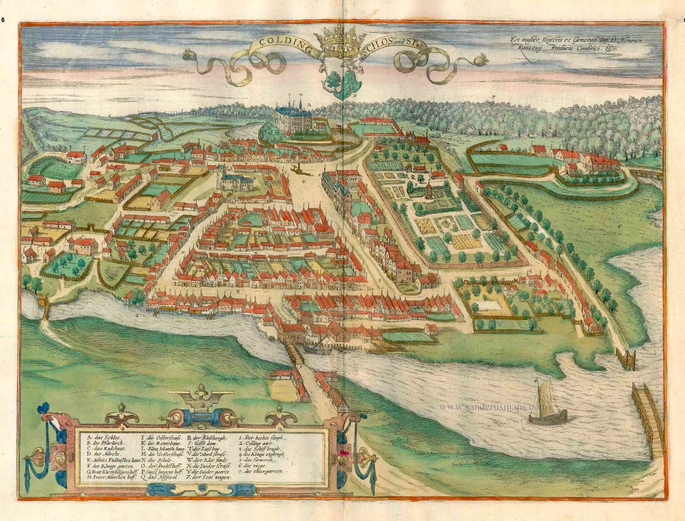
Colding Schloss und Stat c. 1610
Kolding, by Georg Braun and Frans Hogenberg.
[Item number: 16693]
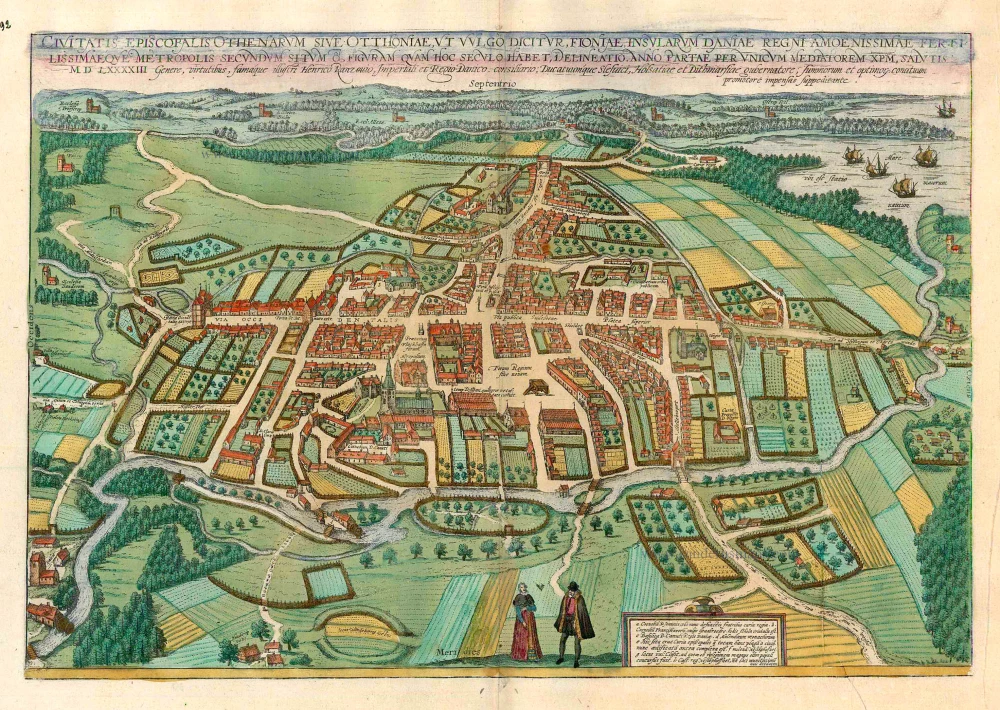
Civitates Episcopalis Othenarum sive Otthoniae, ut vulgo Dicitur, Fioniae ... c. 1610
Odense, by Georg Braun and Frans Hogenberg.
[Item number: 16703]

Carte de l'Etat du Royaume de Dannemarck et diverses observations pour conduire à l'Intelligence de l'Histoire et du Gouvernement de ce Royaume. 1714
Denmark - Copenhagen, by Zacharias Châtelain.
[Item number: 21339]
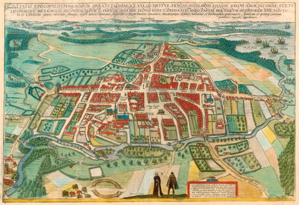
Civitates Episcopalis Othenarum sive Otthoniae, ut vulgo Dicitur, Fioniae ... 1596-1640
Odense, by Georg Braun and Frans Hogenberg.
[Item number: 23372]
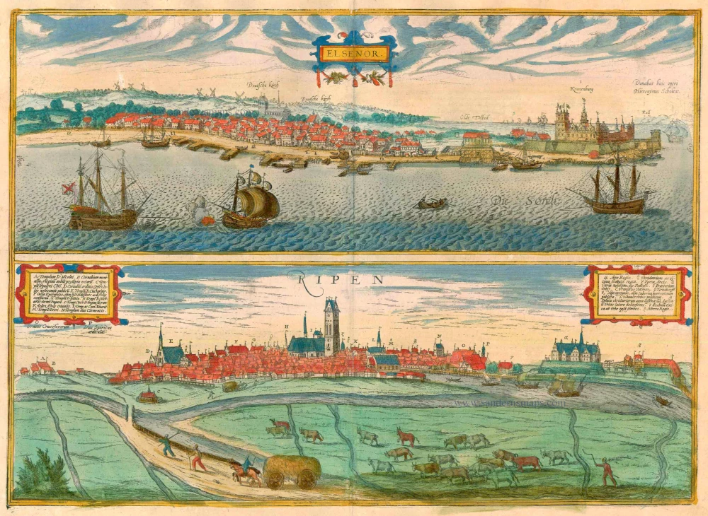
Elsenor [on sheet with] Ripen 1596-1640
Helsingør (Sjaelland) & Ribe (Jutland), by Georg Braun and Frans Hogenberg.
[Item number: 23375]
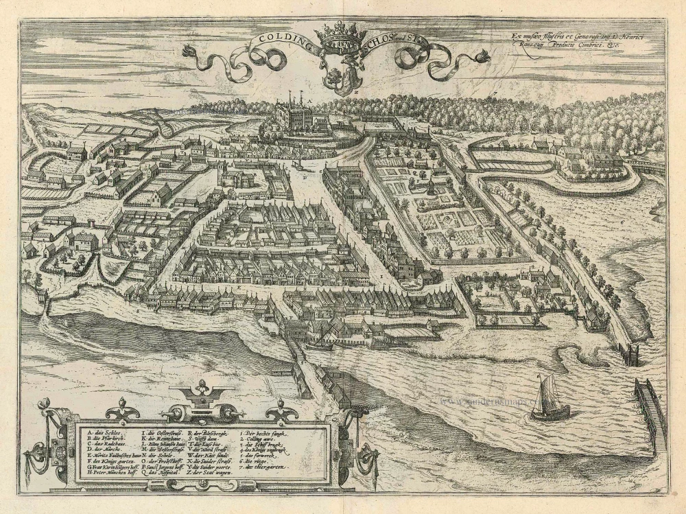
Colding Schloss und Stat 1596
Kolding by Braun and Hogenberg
[Item number: 24163]