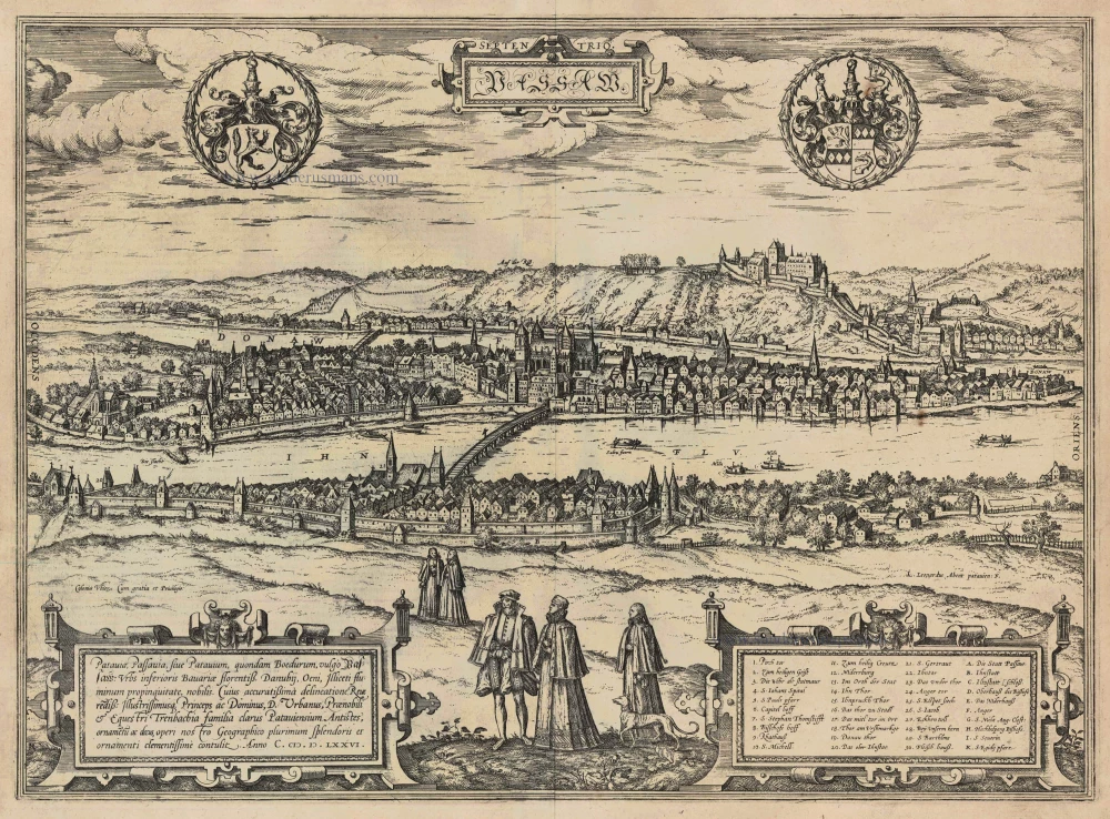
Passau, by Georg Braun and Frans Hogenberg. 1616
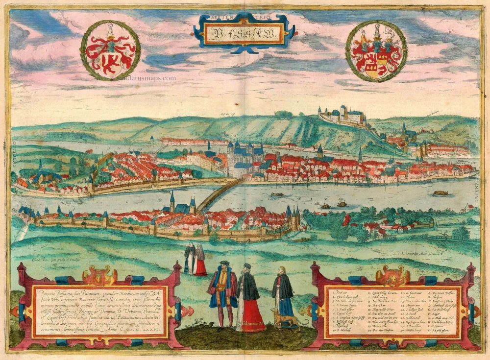
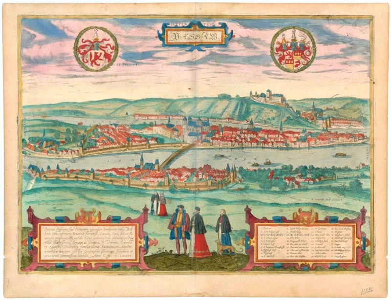


TRANSLATION OF CARTOUCHE TEXT: Patavia, Passavia or Patavium, formerly Boedurum, in German Passau, a flourishing city in Lower Bavaria; known for the confluence of the Danube, Inn and Ilz. With his most accurate drawing, the most reverend and illustrious Lord D. Urbanus of Passau, of the noblest and chivalrous Trenbach family, has contributed most graciously to the decoration, splendour and beauty of our geographical work. In the year 1576.
COMMENTARY BY BRAUN: "Passau lies on the eastern edge of Lower Bavaria, on the border with Austria, at the point where the Danube and the Inn flow together, almost as if on an island in an exceedingly pleasant and beautiful location. It has become very powerful and wealthy due to its bishopric but also due to its merchants, who trade in various wares. For thanks to its fortunate location on the rivers, it is very conveniently situated, and like Lyons in France and Ghent in Flanders has a favourable position for trade and lives in great prosperity."
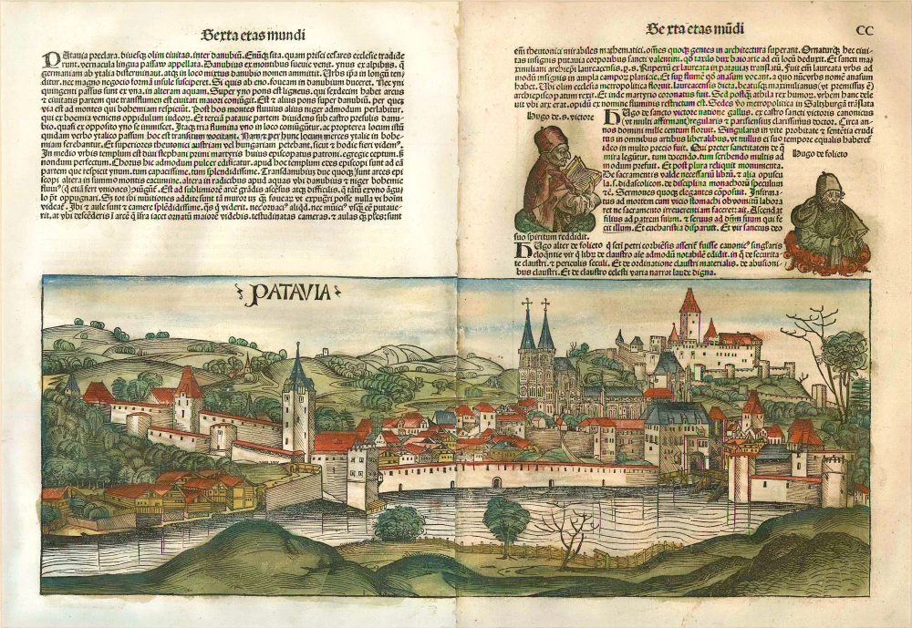
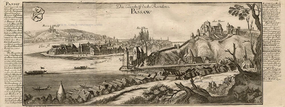
This true-to-life view looks across the Inn to the city of Passau and beyond from the opposite hillside with the pilgrimage church of Mariahilf. The confluence of the Inn and Danube is visible. On the peninsula-shaped Old Town between them, the mighty Gothic cathedral of St Stephen sits on a rise between the two rivers. On the left bank of the Danube, 105 m above the valley on top of St. Georgsberg, lies the fortress of Feste Oberhaus, with below it, on the spit of land between the Danube and the Ilz, the Feste Niederhaus. Passau became a diocese as early as AD 739 and was ruled by the prince-bishop from 1217 onwards.
(Taschen)
Braun G. & Hogenberg F. and the Civitates Orbis Terrarum.
The Civitates Orbis Terrarum, or the "Braun & Hogenberg", is a six-volume town atlas and the most excellent book of town views and plans ever published: 363 engravings, sometimes beautifully coloured. It was one of the best-selling works in the last quarter of the 16th century. Georg Braun wrote the text accompanying the plans and views on the verso. Many plates were engraved after the original drawings of a professional artist, a professional artist, Joris Hoefnagel (1542-1600). The first volume was published in Latin in 1572, and the sixth in 1617. Frans Hogenberg created the tables for volumes I through IV, and Simon van den Neuwel made those for volumes V and VI. Other contributors were cartographers Daniel Freese and Heinrich Rantzau. Works by Jacob van Deventer, Sebastian Münster, and Johannes Stumpf were also used. Translations appeared in German and French.
Following the original publication of Volume 1 of the Civitates in 1572, seven further editions of 1575, 1577, 1582, 1588, 1593, 1599 and 1612 can be identified. Vol.2, first issued in 1575, was followed by further editions in 1597 and 1612. The subsequent volumes appeared in 1581, 1588, 1593, 1599 and 1606. The German translation of the first volume appeared from 1574 on, and the French edition from 1575 on.
Several printers were involved: Theodor Graminaeus, Heinrich von Aich, Gottfried von Kempen, Johannis Sinniger, Bertram Buchholtz and Peter von Brachel, who all worked in Cologne.
Georg Braun (1541-1622)
Georg Braun was born in Cologne in 1541. After his studies in Cologne, he entered the Jesuit Order as a novice. 1561, he obtained his bachelor's degree, and in 1562, he received his Magister Artium. Although he left the Jesuit Order, he studied theology, gaining a licentiate in theology.
Frans Hogenberg (1535-1590)
Frans Hogenberg was a Flemish and German painter, engraver, and mapmaker. He was born in Mechelen as the son of Nicolaas Hogenberg.
By the end of the 1560s, Frans Hogenberg was employed upon Abraham Ortelius's Theatrum Orbis Terrarum, published in 1570; he is named an engraver of numerous maps. In 1568, he was banned from Antwerp by the Duke of Alva and travelled to London, where he stayed a few years before emigrating to Cologne. He immediately embarked on his two most important works, the Civitates, published in 1572 and the Geschichtsblätter, which appeared in several series from 1569 until about 1587.
Thanks to large-scale projects like the Geschichtsblätter and the Civitates, Hogenberg's social circumstances improved with each passing year. He died as a wealthy man in Cologne in 1590.
Passaw.
Item Number: 23326 Authenticity Guarantee
Category: Antique maps > Europe > Germany - Cities
Old, antique bird's-eye view of Passau, by Georg Braun and Frans Hogenberg. Alte, antike Vogelperspektive von Passau von Georg Braun und Frans Hogenberg. Date of the first edition: 1581 Date of this map: 1616 Copper engraving, printed on paper. Size (not including margins): 36.5 x 50cm (14.2 x 19.5 inches) Verso text: Latin Condition: Superb old colour, excellent. Condition Rating: A+ References: Van der Krogt 4, #3326; Taschen, Br. Hog.,, p.208; Fauser, #10674. From: Civitates Orbis Terrarum. - Urbium Praeciuarum Totius Mundi Liber Tertius. Cologne, Petrus von Brachel, 1616. (Van der Krogt 4, 41:1.3) TRANSLATION OF CARTOUCHE TEXT: Patavia, Passavia or Patavium, formerly Boedurum, in German Passau, a flourishing city in Lower Bavaria; known for the confluence of the Danube, Inn and Ilz. With his most accurate drawing, the most reverend and illustrious Lord D. Urbanus of Passau, of the noblest and chivalrous Trenbach family, has contributed most graciously to the decoration, splendour and beauty of our geographical work. In the year 1576. COMMENTARY BY BRAUN: "Passau lies on the eastern edge of Lower Bavaria, on the border with Austria, at the point where the Danube and the Inn flow together, almost as if on an island in an exceedingly pleasant and beautiful location. It has become very powerful and wealthy due to its bishopric but also due to its merchants, who trade in various wares. For thanks to its fortunate location on the rivers, it is very conveniently situated, and like Lyons in France and Ghent in Flanders has a favourable position for trade and lives in great prosperity." This true-to-life view looks across the Inn to the city of Passau and beyond from the opposite hillside with the pilgrimage church of Mariahilf. The confluence of the Inn and Danube is visible. On the peninsula-shaped Old Town between them, the mighty Gothic cathedral of St Stephen sits on a rise between the two rivers. On the left bank of the Danube, 105 m above the valley on top of St. Georgsberg, lies the fortress of Feste Oberhaus, with below it, on the spit of land between the Danube and the Ilz, the Feste Niederhaus. Passau became a diocese as early as AD 739 and was ruled by the prince-bishop from 1217 onwards. (Taschen)
TRANSLATION OF CARTOUCHE TEXT: Patavia, Passavia or Patavium, formerly Boedurum, in German Passau, a flourishing city in Lower Bavaria; known for the confluence of the Danube, Inn and Ilz. With his most accurate drawing, the most reverend and illustrious Lord D. Urbanus of Passau, of the noblest and chivalrous Trenbach family, has contributed most graciously to the decoration, splendour and beauty of our geographical work. In the year 1576.
COMMENTARY BY BRAUN: "Passau lies on the eastern edge of Lower Bavaria, on the border with Austria, at the point where the Danube and the Inn flow together, almost as if on an island in an exceedingly pleasant and beautiful location. It has become very powerful and wealthy due to its bishopric but also due to its merchants, who trade in various wares. For thanks to its fortunate location on the rivers, it is very conveniently situated, and like Lyons in France and Ghent in Flanders has a favourable position for trade and lives in great prosperity."
This true-to-life view looks across the Inn to the city of Passau and beyond from the opposite hillside with the pilgrimage church of Mariahilf. The confluence of the Inn and Danube is visible. On the peninsula-shaped Old Town between them, the mighty Gothic cathedral of St Stephen sits on a rise between the two rivers. On the left bank of the Danube, 105 m above the valley on top of St. Georgsberg, lies the fortress of Feste Oberhaus, with below it, on the spit of land between the Danube and the Ilz, the Feste Niederhaus. Passau became a diocese as early as AD 739 and was ruled by the prince-bishop from 1217 onwards.
(Taschen)
Braun G. & Hogenberg F. and the Civitates Orbis Terrarum.
The Civitates Orbis Terrarum, or the "Braun & Hogenberg", is a six-volume town atlas and the most excellent book of town views and plans ever published: 363 engravings, sometimes beautifully coloured. It was one of the best-selling works in the last quarter of the 16th century. Georg Braun wrote the text accompanying the plans and views on the verso. Many plates were engraved after the original drawings of a professional artist, a professional artist, Joris Hoefnagel (1542-1600). The first volume was published in Latin in 1572, and the sixth in 1617. Frans Hogenberg created the tables for volumes I through IV, and Simon van den Neuwel made those for volumes V and VI. Other contributors were cartographers Daniel Freese and Heinrich Rantzau. Works by Jacob van Deventer, Sebastian Münster, and Johannes Stumpf were also used. Translations appeared in German and French.
Following the original publication of Volume 1 of the Civitates in 1572, seven further editions of 1575, 1577, 1582, 1588, 1593, 1599 and 1612 can be identified. Vol.2, first issued in 1575, was followed by further editions in 1597 and 1612. The subsequent volumes appeared in 1581, 1588, 1593, 1599 and 1606. The German translation of the first volume appeared from 1574 on, and the French edition from 1575 on.
Several printers were involved: Theodor Graminaeus, Heinrich von Aich, Gottfried von Kempen, Johannis Sinniger, Bertram Buchholtz and Peter von Brachel, who all worked in Cologne.
Georg Braun (1541-1622)
Georg Braun was born in Cologne in 1541. After his studies in Cologne, he entered the Jesuit Order as a novice. 1561, he obtained his bachelor's degree, and in 1562, he received his Magister Artium. Although he left the Jesuit Order, he studied theology, gaining a licentiate in theology.
Frans Hogenberg (1535-1590)
Frans Hogenberg was a Flemish and German painter, engraver, and mapmaker. He was born in Mechelen as the son of Nicolaas Hogenberg.
By the end of the 1560s, Frans Hogenberg was employed upon Abraham Ortelius's Theatrum Orbis Terrarum, published in 1570; he is named an engraver of numerous maps. In 1568, he was banned from Antwerp by the Duke of Alva and travelled to London, where he stayed a few years before emigrating to Cologne. He immediately embarked on his two most important works, the Civitates, published in 1572 and the Geschichtsblätter, which appeared in several series from 1569 until about 1587.
Thanks to large-scale projects like the Geschichtsblätter and the Civitates, Hogenberg's social circumstances improved with each passing year. He died as a wealthy man in Cologne in 1590.