
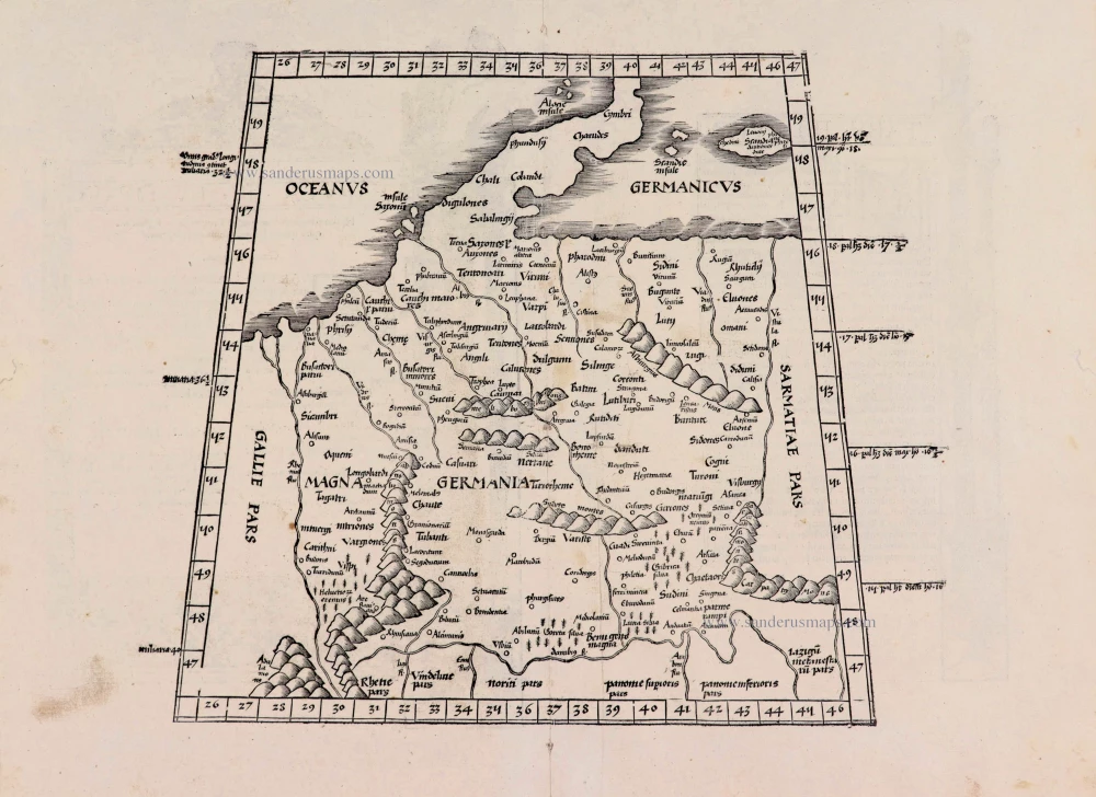
Germania by Jodocus Hondius. 1630

This beautiful and rare map by Jodocus Hondius is a close copy of the 1621 map by Visscher. The map is surrounded on all sides by figures, town views and coats of arms. The title in capitals and the Imperial coat of arms in the centre of the top border is surrounded by the emperor and the seven Electors on horseback in a half-circular arch. Along the bottom border runs a series of ten town views with four coats of arms underneath: Frankfurt, Augsburg, Metz, Leipzig, Strassbourg, Lubeck, Heidelberg, Braunschweig, Trier and Hamburg. Left border: three costumed figures and the town views Prague, Spiers, Nürnberg and Basel. Right border: three costumed figures and the town views of Cologne, Vienna, Regensburg and Ulm.
In 1630 Jodocus Hondius' imprint was replaced by that of Everard Cloppenburg.
The Hondius Family
Jodocus Hondius the Elder (1563-1612)
Joost d’Hondt was born at Wakken (Flanders) in 1563. Two years later, his family settled in Ghent, where young Joost displayed an excellent gift for drawing and calligraphy. Through study and lessons, he developed his talents and became an engraver with a good reputation.
Due to the circumstances of the war, he moved to London in 1584, where he settled down as an engraver, instrument-maker, and map-maker. In 1587, he married Coletta van den Keere, sister of the well-known engraver Pieter van den Keere (Petrus Kaerius); some years earlier, his sister, Jacomina, had married Pieter van den Berghe (Petrus Montanus). Joost, who had Latinized his name to Jodocus Hondius, closely co-operated with his two brothers-in-law.
The political situation in the Northern Netherlands in 1593 was such that Jodocus seemed justified in establishing himself in Amsterdam, where many Antwerp printers, publishers, and engravers had gone. In this new centre of cartography, Jodocus Hondius set up his business “In de Wackere Hondt” (in the vigilant dog), this name being an allusion to his birthplace and name. He engraved many maps and published atlases and many other works, such as his continuation of Gerard Mercator’s Atlas.
He suddenly passed away in February 1612. The publishing firm of Jodocus Hondius was continued by his widow, later on, by his two sons, Jodocus Jr. and Henricus, and by his son-in-law, J. Janssonius.
Jodocus Hondius II (1594-1629) & Henricus Hondius (1597-1651)
After the father’s death, the widow and her seven children continued publishing the atlases under the name of Jodocus Hondius till 1620. The firm was reinforced by the very welcome help of Joannes Janssonius (1588-1664), who married 24-year-old Elisabeth Hondius in 1612. After 1619, Mercator’s Atlas was published under the name of Henricus Hondius.
One of the most dramatic events in the early history of commercial cartography in Amsterdam was the sale of Jodocus Hondius Jr.’s copper plates to Willem Jansz. Blaeu in 1629, the year of his death. At least 34 plates, from which Jodocus II had printed single-sheet maps for his benefit, passed into the hands of his great competitor. Immediately after that, his brother, Henricus, and Joannes Janssonius ordered the engraving of identical plates.
Henricus devoted all his energy to publishing the Atlas for an extended period. He saw its growth up to and including the fourth part in 1646; after that, his name no longer figures on the title pages. After 1638, the title of the Atlas was changed to Atlas Novus; Joannes Janssonius mainly carried it on.
The competition with the Blaeu's dates from 1630. In 1630, Willem Janszoon (=Blaeu) first attacked with his Atlantis Appendix. In 1635, Blaeu completed his Theatrum Orbis Terrarum in two volumes with French, Latin, Dutch, and German texts, prompting Henricus Hondius to speed up the enlargement of his Atlas.
Germaniae Nova ac accurata descriptio Ubicumque B. Lector talem (*) viderit adteriscum cogitabit inibi esse Academiam.
Item Number: 18634 Authenticity Guarantee
Category: Antique maps > Europe > Germany
Old, antique map of Germania, by Hondius J..
Title: Germaniae Nova ac accurata descriptio Ubicumque B. Lector talem (*) viderit adteriscum cogitabit inibi esse Academiam.
Amstelodami Everardus Cloppenburg excudit 1630.
Date of the first edition: 1630.
Date of this map: 1630.
Date on map: 1630.
Copper engraving, printed on paper.
Size (not including margins): 450 x 555mm (17.72 x 21.85 inches).
Verso: Blank.
Condition: Original coloured, refreshed, folds flattened.
Condition Rating: A+.
References: Schilder 6, 37.2
From: Separate publication.
This beautiful and rare map by Jodocus Hondius is a close copy of the 1621 map by Visscher. The map is surrounded on all sides by figures, town views and coats of arms. The title in capitals and the Imperial coat of arms in the centre of the top border is surrounded by the emperor and the seven Electors on horseback in a half-circular arch. Along the bottom border runs a series of ten town views with four coats of arms underneath: Frankfurt, Augsburg, Metz, Leipzig, Strassbourg, Lubeck, Heidelberg, Braunschweig, Trier and Hamburg. Left border: three costumed figures and the town views Prague, Spiers, Nürnberg and Basel. Right border: three costumed figures and the town views of Cologne, Vienna, Regensburg and Ulm.
In 1630 Jodocus Hondius' imprint was replaced by that of Everard Cloppenburg.
The Hondius Family
Jodocus Hondius the Elder (1563-1612)
Joost d’Hondt was born at Wakken (Flanders) in 1563. Two years later, his family settled in Ghent, where young Joost displayed an excellent gift for drawing and calligraphy. Through study and lessons, he developed his talents and became an engraver with a good reputation.
Due to the circumstances of the war, he moved to London in 1584, where he settled down as an engraver, instrument-maker, and map-maker. In 1587, he married Coletta van den Keere, sister of the well-known engraver Pieter van den Keere (Petrus Kaerius); some years earlier, his sister, Jacomina, had married Pieter van den Berghe (Petrus Montanus). Joost, who had Latinized his name to Jodocus Hondius, closely co-operated with his two brothers-in-law.
The political situation in the Northern Netherlands in 1593 was such that Jodocus seemed justified in establishing himself in Amsterdam, where many Antwerp printers, publishers, and engravers had gone. In this new centre of cartography, Jodocus Hondius set up his business “In de Wackere Hondt” (in the vigilant dog), this name being an allusion to his birthplace and name. He engraved many maps and published atlases and many other works, such as his continuation of Gerard Mercator’s Atlas.
He suddenly passed away in February 1612. The publishing firm of Jodocus Hondius was continued by his widow, later on, by his two sons, Jodocus Jr. and Henricus, and by his son-in-law, J. Janssonius.
Jodocus Hondius II (1594-1629) & Henricus Hondius (1597-1651)
After the father’s death, the widow and her seven children continued publishing the atlases under the name of Jodocus Hondius till 1620. The firm was reinforced by the very welcome help of Joannes Janssonius (1588-1664), who married 24-year-old Elisabeth Hondius in 1612. After 1619, Mercator’s Atlas was published under the name of Henricus Hondius.
One of the most dramatic events in the early history of commercial cartography in Amsterdam was the sale of Jodocus Hondius Jr.’s copper plates to Willem Jansz. Blaeu in 1629, the year of his death. At least 34 plates, from which Jodocus II had printed single-sheet maps for his benefit, passed into the hands of his great competitor. Immediately after that, his brother, Henricus, and Joannes Janssonius ordered the engraving of identical plates.
Henricus devoted all his energy to publishing the Atlas for an extended period. He saw its growth up to and including the fourth part in 1646; after that, his name no longer figures on the title pages. After 1638, the title of the Atlas was changed to Atlas Novus; Joannes Janssonius mainly carried it on.
The competition with the Blaeu's dates from 1630. In 1630, Willem Janszoon (=Blaeu) first attacked with his Atlantis Appendix. In 1635, Blaeu completed his Theatrum Orbis Terrarum in two volumes with French, Latin, Dutch, and German texts, prompting Henricus Hondius to speed up the enlargement of his Atlas.
Related items
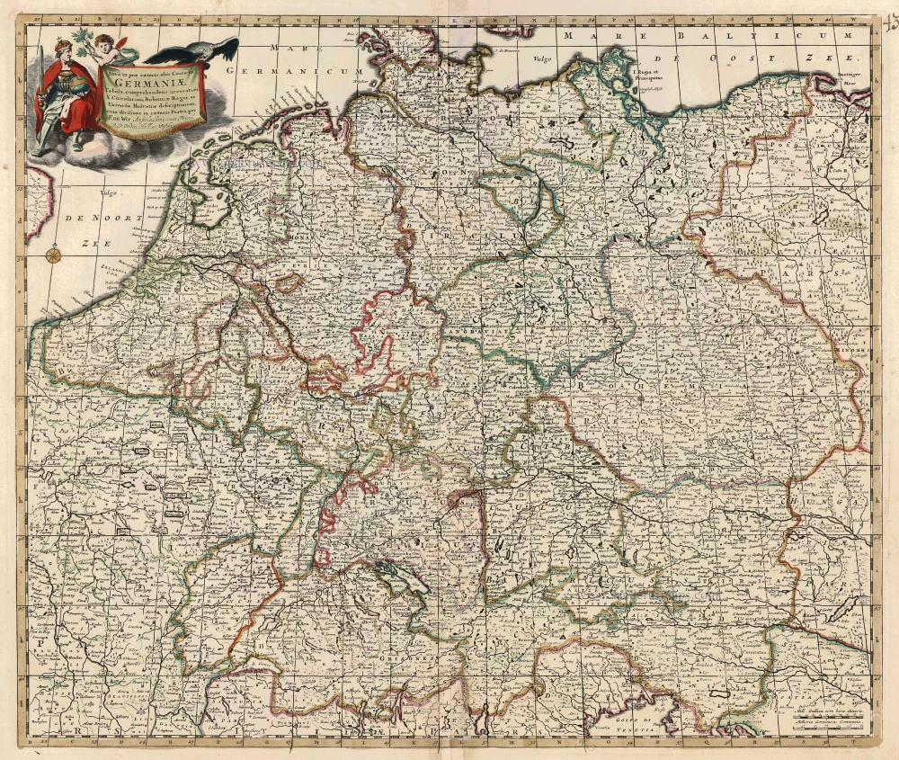
Nova et prae caeteris aliis Correcta Germaniae Tabula, comprehendens accuratam X. Circulorum, Bohemiae Regni, ac Universae Helvetiae descriptionem. c. 1680
GERMANIA by de Wit F.
[Item number: 24404]
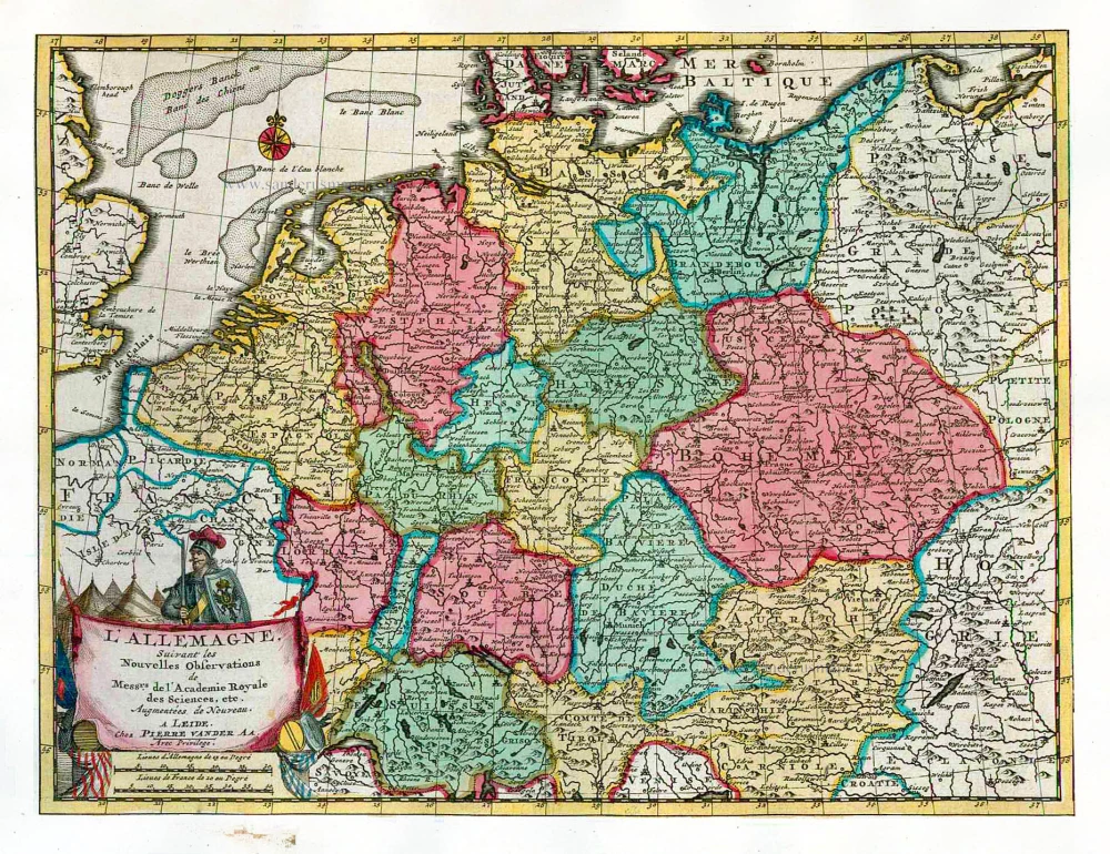
L'Allemagne. 1713
Germania, by P. Van der Aa.
[Item number: 26178]
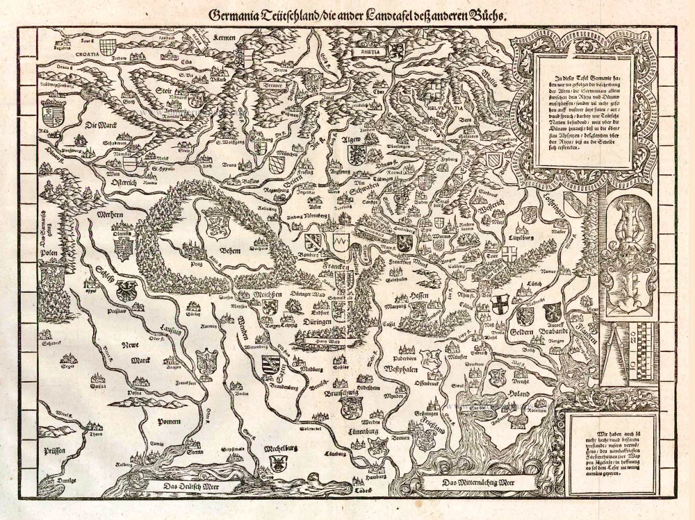
Germania Teütschland / die ander Landtafel desz anderen Büchs. 1548
Germania, by Johannes Stumpf.
[Item number: 26203]
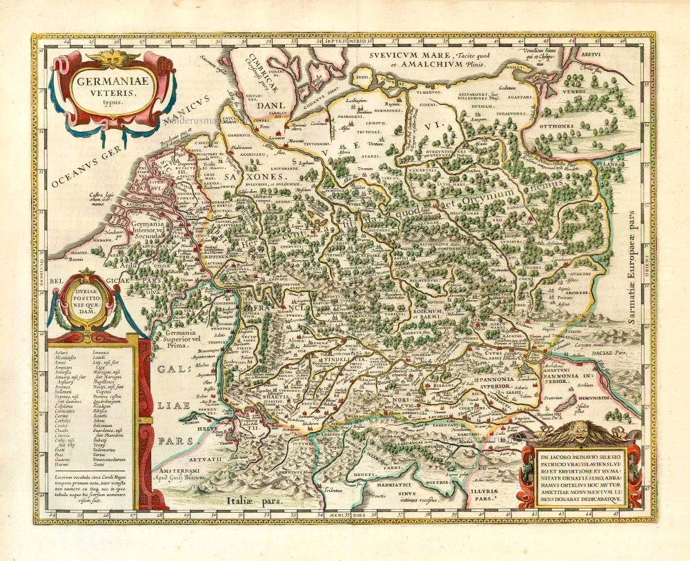
Germaniae Veteris Typus. 1643
Ancient Germania, by Willem Blaeu.
[Item number: 27122]
[No title] - [On verso:] Tabula .IIII. Europae. 1525
Ptolemaic Germania, by Lorenz Fries.
[Item number: 27958]