
Sicily - Catana with view of the Mount Etna by Georg Braun & Frans Hogenberg 1617
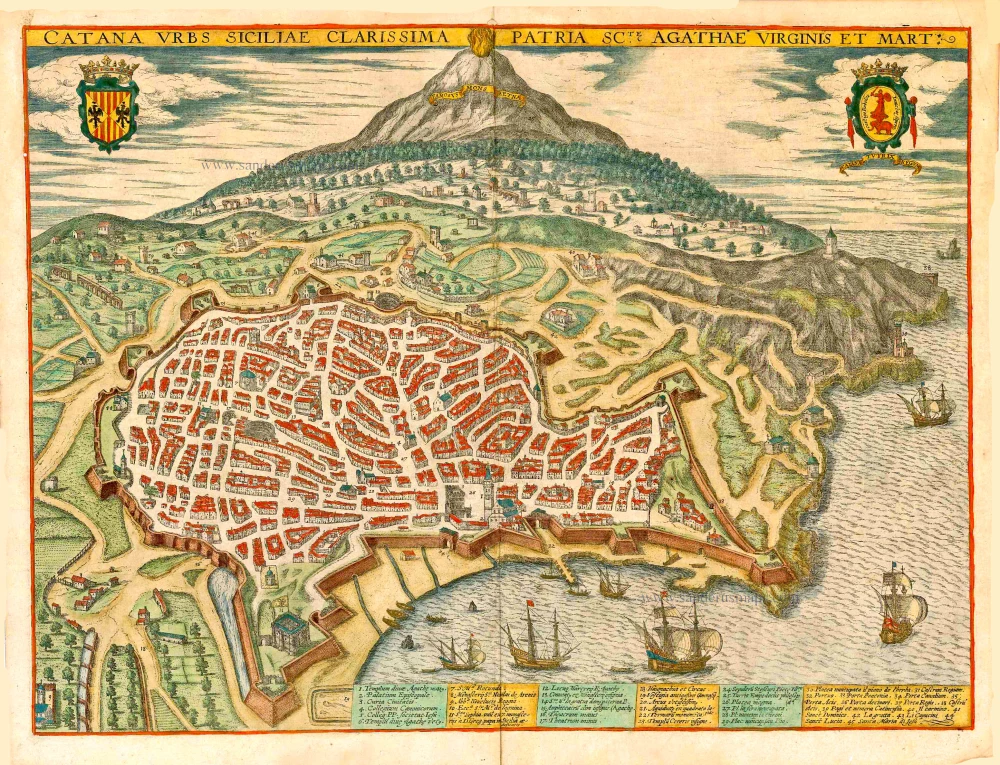
TRANSLATION OF CAPTION: Catania, the very famous town in Sicily, birthplace of St Agatha, virgin and martyr.
COMMENTARY BY BRAUN (on verso): "Catania is a very old town in Sicily, which was praised by the Greek and Roman authors. It borders on the sea on one side and Etna on the other [...]. On the side from which one sails for Naxos, the town formerly had a magnificent maritime harbour; this was filled in by Etna's enormous eruption, however, so that nothing but a mound of large rocks lies on this spot today. The town was formerly also very well known for its mounted troops. Today the city is famous for the Liberal Arts that are taught there. One also finds here people very learned in imperial and papal law."
The engraving offers a bird's-eye view from the south of the formerly well-fortified town of Catania with Mount Etna rising directly behind it. On the Piazza del Duomo (26), the cathedral of Sant'Agata lies opposite the town hall (3). Preserved within the town are a number of antique monuments, including the amphitheatre (15) incorporated into the city wall: originally able to hold up 15,000 spectators; it was almost as large as the Coliseum in Rome. To the left lies the church of Sant'Agata al Carcere (6), built in honour of the town's patron saint on the site where she was imprisoned before her death. The founding of Catania goes back to the 8th century AD, when it was settled by Greeks from the Island of Naxos. The town was entirely destroyed in 1669 following a massive eruption by Etna and in 1693 by a catastrophic earthquake. Black lava stone was used to rebuilt the town, which is why it is often described as Etna's "black daughter". (Taschen)
Braun G. & Hogenberg F. and the Civitates Orbis Terrarum.
The Civitates Orbis Terrarum, or the "Braun & Hogenberg", is a six-volume town atlas and the most excellent book of town views and plans ever published: 363 engravings, sometimes beautifully coloured. It was one of the best-selling works in the last quarter of the 16th century. Georg Braun wrote the text accompanying the plans and views on the verso. Many plates were engraved after the original drawings of a professional artist, a professional artist, Joris Hoefnagel (1542-1600). The first volume was published in Latin in 1572, and the sixth in 1617. Frans Hogenberg created the tables for volumes I through IV, and Simon van den Neuwel made those for volumes V and VI. Other contributors were cartographers Daniel Freese and Heinrich Rantzau. Works by Jacob van Deventer, Sebastian Münster, and Johannes Stumpf were also used. Translations appeared in German and French.
Following the original publication of Volume 1 of the Civitates in 1572, seven further editions of 1575, 1577, 1582, 1588, 1593, 1599 and 1612 can be identified. Vol.2, first issued in 1575, was followed by further editions in 1597 and 1612. The subsequent volumes appeared in 1581, 1588, 1593, 1599 and 1606. The German translation of the first volume appeared from 1574 on, and the French edition from 1575 on.
Several printers were involved: Theodor Graminaeus, Heinrich von Aich, Gottfried von Kempen, Johannis Sinniger, Bertram Buchholtz and Peter von Brachel, who all worked in Cologne.
Georg Braun (1541-1622)
Georg Braun was born in Cologne in 1541. After his studies in Cologne, he entered the Jesuit Order as a novice. 1561, he obtained his bachelor's degree, and in 1562, he received his Magister Artium. Although he left the Jesuit Order, he studied theology, gaining a licentiate in theology.
Frans Hogenberg (1535-1590)
Frans Hogenberg was a Flemish and German painter, engraver, and mapmaker. He was born in Mechelen as the son of Nicolaas Hogenberg.
By the end of the 1560s, Frans Hogenberg was employed upon Abraham Ortelius's Theatrum Orbis Terrarum, published in 1570; he is named an engraver of numerous maps. In 1568, he was banned from Antwerp by the Duke of Alva and travelled to London, where he stayed a few years before emigrating to Cologne. He immediately embarked on his two most important works, the Civitates, published in 1572 and the Geschichtsblätter, which appeared in several series from 1569 until about 1587.
Thanks to large-scale projects like the Geschichtsblätter and the Civitates, Hogenberg's social circumstances improved with each passing year. He died as a wealthy man in Cologne in 1590.
Catana Urbs Siciliae Clarissima Patriae Scte Agathae Virginis et Mart:
Item Number: 27653 Authenticity Guarantee
Category: Antique maps > Europe > Italy - Cities
Antique bird's-eye view of Catania, with Mount Etna in the background, by Georg Braun and Frans Hogenberg.
Antica veduta a volo d'uccello di Catania, con l'Etna sullo sfondo, di Georg Braun e Frans Hogenberg.
Key identifying 45 locations.
Date of the first edition: 1596
Date of this map: 1617
Copper engraving, printed on paper.
Size (not including margins): 37 x 49.5cm (14.4 x 19.3 inches)
Verso text: Latin
Condition: Original coloured, excellent.
Condition Rating: A+
References: Van der Krogt 4, #828, State 1; Fauser, #2410; Taschen, Br. Hog., p.430.
From: G. Braun & F. Hogenberg. Civitates Orbis Terrarum. - Urbium Praecipuarum Mundi Theatrum Quintum. Cologne, Petrus von Brachel, 1617. (Van der Krogt 41:1.5 (1617)).
TRANSLATION OF CAPTION: Catania, the very famous town in Sicily, birthplace of St Agatha, virgin and martyr.
COMMENTARY BY BRAUN (on verso): "Catania is a very old town in Sicily, which was praised by the Greek and Roman authors. It borders on the sea on one side and Etna on the other [...]. On the side from which one sails for Naxos, the town formerly had a magnificent maritime harbour; this was filled in by Etna's enormous eruption, however, so that nothing but a mound of large rocks lies on this spot today. The town was formerly also very well known for its mounted troops. Today the city is famous for the Liberal Arts that are taught there. One also finds here people very learned in imperial and papal law."
The engraving offers a bird's-eye view from the south of the formerly well-fortified town of Catania with Mount Etna rising directly behind it. On the Piazza del Duomo (26), the cathedral of Sant'Agata lies opposite the town hall (3). Preserved within the town are a number of antique monuments, including the amphitheatre (15) incorporated into the city wall: originally able to hold up 15,000 spectators; it was almost as large as the Coliseum in Rome. To the left lies the church of Sant'Agata al Carcere (6), built in honour of the town's patron saint on the site where she was imprisoned before her death. The founding of Catania goes back to the 8th century AD, when it was settled by Greeks from the Island of Naxos. The town was entirely destroyed in 1669 following a massive eruption by Etna and in 1693 by a catastrophic earthquake. Black lava stone was used to rebuilt the town, which is why it is often described as Etna's "black daughter". (Taschen)
Braun G. & Hogenberg F. and the Civitates Orbis Terrarum.
The Civitates Orbis Terrarum, or the "Braun & Hogenberg", is a six-volume town atlas and the most excellent book of town views and plans ever published: 363 engravings, sometimes beautifully coloured. It was one of the best-selling works in the last quarter of the 16th century. Georg Braun wrote the text accompanying the plans and views on the verso. Many plates were engraved after the original drawings of a professional artist, a professional artist, Joris Hoefnagel (1542-1600). The first volume was published in Latin in 1572, and the sixth in 1617. Frans Hogenberg created the tables for volumes I through IV, and Simon van den Neuwel made those for volumes V and VI. Other contributors were cartographers Daniel Freese and Heinrich Rantzau. Works by Jacob van Deventer, Sebastian Münster, and Johannes Stumpf were also used. Translations appeared in German and French.
Following the original publication of Volume 1 of the Civitates in 1572, seven further editions of 1575, 1577, 1582, 1588, 1593, 1599 and 1612 can be identified. Vol.2, first issued in 1575, was followed by further editions in 1597 and 1612. The subsequent volumes appeared in 1581, 1588, 1593, 1599 and 1606. The German translation of the first volume appeared from 1574 on, and the French edition from 1575 on.
Several printers were involved: Theodor Graminaeus, Heinrich von Aich, Gottfried von Kempen, Johannis Sinniger, Bertram Buchholtz and Peter von Brachel, who all worked in Cologne.
Georg Braun (1541-1622)
Georg Braun was born in Cologne in 1541. After his studies in Cologne, he entered the Jesuit Order as a novice. 1561, he obtained his bachelor's degree, and in 1562, he received his Magister Artium. Although he left the Jesuit Order, he studied theology, gaining a licentiate in theology.
Frans Hogenberg (1535-1590)
Frans Hogenberg was a Flemish and German painter, engraver, and mapmaker. He was born in Mechelen as the son of Nicolaas Hogenberg.
By the end of the 1560s, Frans Hogenberg was employed upon Abraham Ortelius's Theatrum Orbis Terrarum, published in 1570; he is named an engraver of numerous maps. In 1568, he was banned from Antwerp by the Duke of Alva and travelled to London, where he stayed a few years before emigrating to Cologne. He immediately embarked on his two most important works, the Civitates, published in 1572 and the Geschichtsblätter, which appeared in several series from 1569 until about 1587.
Thanks to large-scale projects like the Geschichtsblätter and the Civitates, Hogenberg's social circumstances improved with each passing year. He died as a wealthy man in Cologne in 1590.