
Venice (Venezia) by Georg Braun & Frans Hogenberg 1599
The item displayed on this page has been sold. However, we have a similar map in stock:
Venice (Venezia) by Georg Braun & Frans Hogenberg. 1577
Venetia.
[Item number: 30240]

COMMENTARY BY BRAUN: "Venice is divided into six districts; near the shore, one can see two huge columns, one of which stands the symbol of St Mark, the winged lion, on the other St Theodore. Between these columns is the place where criminals are punished. The market square is embellished by the magnificent and wonderful church of St Mark, which was built of precious and costly marble. [...] The city's streets are intersected by canals, spanned by wooden and stone bridges, of which some 400 can be counted. There are, however, over 8,000 small boats in which one can travel to and fro."
Venice played an undisputed leading role in trade between East and West for centuries due to its geographical position. In the 15th/16th centuries, the city on the lagoon, with a population of some 150,000, also experienced a flowering of the arts. The 400 bridges over its 180 canals include the famous Rialto (150), the only bridge over the Grand Canal at that time. The original wooden bridge, with its many stalls and shops, was replaced in 1591 by a stone bridge. Standing out from amongst the sea of buildings - supported on millions of wooden piles - are St Mark's Square with the cathedral, the bell tower and the two columns bearing the city's patron saints, Mark (represented by a lion) and Theodore. Opposite St Mark's Square lies the Island of San Giorgio with its monastery and church. Above the city is Murano, where all of Venice's glass-making workshops were moved in the 13th century for fire prevention reasons. Ships, boats and Venetian gondolas fill the harbour. (Taschen)
Braun G. & Hogenberg F. and the Civitates Orbis Terrarum.
The Civitates Orbis Terrarum, or the "Braun & Hogenberg", is a six-volume town atlas and the most excellent book of town views and plans ever published: 363 engravings, sometimes beautifully coloured. It was one of the best-selling works in the last quarter of the 16th century. Georg Braun wrote the text accompanying the plans and views on the verso. Many plates were engraved after the original drawings of a professional artist, a professional artist, Joris Hoefnagel (1542-1600). The first volume was published in Latin in 1572, and the sixth in 1617. Frans Hogenberg created the tables for volumes I through IV, and Simon van den Neuwel made those for volumes V and VI. Other contributors were cartographers Daniel Freese and Heinrich Rantzau. Works by Jacob van Deventer, Sebastian Münster, and Johannes Stumpf were also used. Translations appeared in German and French.
Following the original publication of Volume 1 of the Civitates in 1572, seven further editions of 1575, 1577, 1582, 1588, 1593, 1599 and 1612 can be identified. Vol.2, first issued in 1575, was followed by further editions in 1597 and 1612. The subsequent volumes appeared in 1581, 1588, 1593, 1599 and 1606. The German translation of the first volume appeared from 1574 on, and the French edition from 1575 on.
Several printers were involved: Theodor Graminaeus, Heinrich von Aich, Gottfried von Kempen, Johannis Sinniger, Bertram Buchholtz and Peter von Brachel, who all worked in Cologne.
Georg Braun (1541-1622)
Georg Braun was born in Cologne in 1541. After his studies in Cologne, he entered the Jesuit Order as a novice. 1561, he obtained his bachelor's degree, and in 1562, he received his Magister Artium. Although he left the Jesuit Order, he studied theology, gaining a licentiate in theology.
Frans Hogenberg (1535-1590)
Frans Hogenberg was a Flemish and German painter, engraver, and mapmaker. He was born in Mechelen as the son of Nicolaas Hogenberg.
By the end of the 1560s, Frans Hogenberg was employed upon Abraham Ortelius's Theatrum Orbis Terrarum, published in 1570; he is named an engraver of numerous maps. In 1568, he was banned from Antwerp by the Duke of Alva and travelled to London, where he stayed a few years before emigrating to Cologne. He immediately embarked on his two most important works, the Civitates, published in 1572 and the Geschichtsblätter, which appeared in several series from 1569 until about 1587.
Thanks to large-scale projects like the Geschichtsblätter and the Civitates, Hogenberg's social circumstances improved with each passing year. He died as a wealthy man in Cologne in 1590.
Venetia.
Item Number: 26742 Authenticity Guarantee
Category: Antique maps > Europe > Italy - Cities
Venice (Venezia) by Georg Braun & Frans Hogenberg.
Title: Venetia.
Date of the first edition: 1572.
Date of this map: 1599.
Copper engraving, printed on paper.
Size (not including margins): 335 x 483mm (13.19 x 19.02 inches).
Verso: Latin text.
Condition: Original coloured, excellent.
Condition Rating: A+.
From: Civitates Orbis Terrarum, Liber Primus. Köln, Bertram Buchholtz, 1599. (Van der Krogt 4, 41:1.1)
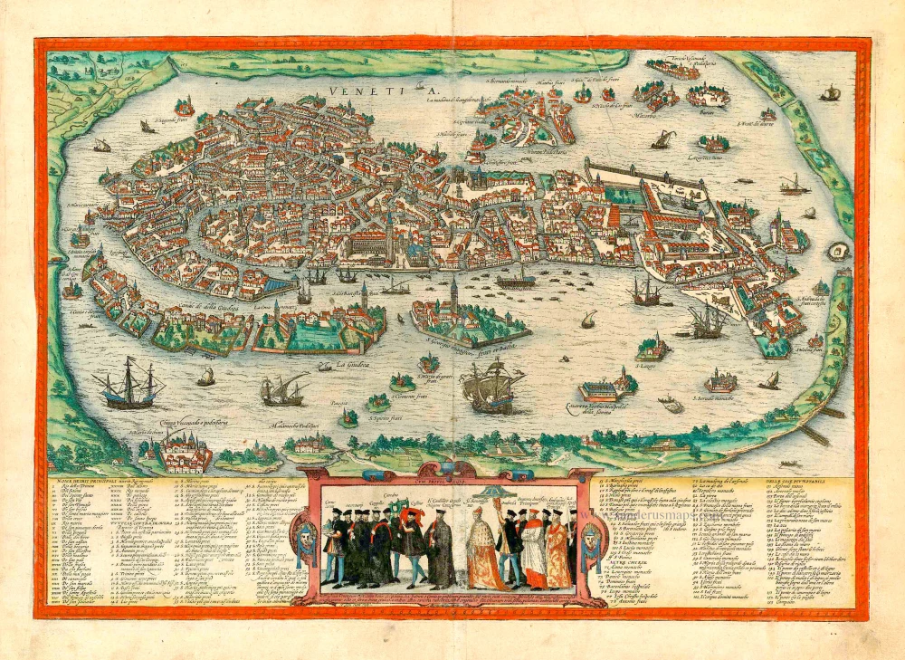
COMMENTARY BY BRAUN: "Venice is divided into six districts; near the shore, one can see two huge columns, one of which stands the symbol of St Mark, the winged lion, on the other St Theodore. Between these columns is the place where criminals are punished. The market square is embellished by the magnificent and wonderful church of St Mark, which was built of precious and costly marble. [...] The city's streets are intersected by canals, spanned by wooden and stone bridges, of which some 400 can be counted. There are, however, over 8,000 small boats in which one can travel to and fro."
Venice played an undisputed leading role in trade between East and West for centuries due to its geographical position. In the 15th/16th centuries, the city on the lagoon, with a population of some 150,000, also experienced a flowering of the arts. The 400 bridges over its 180 canals include the famous Rialto (150), the only bridge over the Grand Canal at that time. The original wooden bridge, with its many stalls and shops, was replaced in 1591 by a stone bridge. Standing out from amongst the sea of buildings - supported on millions of wooden piles - are St Mark's Square with the cathedral, the bell tower and the two columns bearing the city's patron saints, Mark (represented by a lion) and Theodore. Opposite St Mark's Square lies the Island of San Giorgio with its monastery and church. Above the city is Murano, where all of Venice's glass-making workshops were moved in the 13th century for fire prevention reasons. Ships, boats and Venetian gondolas fill the harbour. (Taschen)
Braun G. & Hogenberg F. and the Civitates Orbis Terrarum.
The Civitates Orbis Terrarum, or the "Braun & Hogenberg", is a six-volume town atlas and the most excellent book of town views and plans ever published: 363 engravings, sometimes beautifully coloured. It was one of the best-selling works in the last quarter of the 16th century. Georg Braun wrote the text accompanying the plans and views on the verso. Many plates were engraved after the original drawings of a professional artist, a professional artist, Joris Hoefnagel (1542-1600). The first volume was published in Latin in 1572, and the sixth in 1617. Frans Hogenberg created the tables for volumes I through IV, and Simon van den Neuwel made those for volumes V and VI. Other contributors were cartographers Daniel Freese and Heinrich Rantzau. Works by Jacob van Deventer, Sebastian Münster, and Johannes Stumpf were also used. Translations appeared in German and French.
Following the original publication of Volume 1 of the Civitates in 1572, seven further editions of 1575, 1577, 1582, 1588, 1593, 1599 and 1612 can be identified. Vol.2, first issued in 1575, was followed by further editions in 1597 and 1612. The subsequent volumes appeared in 1581, 1588, 1593, 1599 and 1606. The German translation of the first volume appeared from 1574 on, and the French edition from 1575 on.
Several printers were involved: Theodor Graminaeus, Heinrich von Aich, Gottfried von Kempen, Johannis Sinniger, Bertram Buchholtz and Peter von Brachel, who all worked in Cologne.
Georg Braun (1541-1622)
Georg Braun was born in Cologne in 1541. After his studies in Cologne, he entered the Jesuit Order as a novice. 1561, he obtained his bachelor's degree, and in 1562, he received his Magister Artium. Although he left the Jesuit Order, he studied theology, gaining a licentiate in theology.
Frans Hogenberg (1535-1590)
Frans Hogenberg was a Flemish and German painter, engraver, and mapmaker. He was born in Mechelen as the son of Nicolaas Hogenberg.
By the end of the 1560s, Frans Hogenberg was employed upon Abraham Ortelius's Theatrum Orbis Terrarum, published in 1570; he is named an engraver of numerous maps. In 1568, he was banned from Antwerp by the Duke of Alva and travelled to London, where he stayed a few years before emigrating to Cologne. He immediately embarked on his two most important works, the Civitates, published in 1572 and the Geschichtsblätter, which appeared in several series from 1569 until about 1587.
Thanks to large-scale projects like the Geschichtsblätter and the Civitates, Hogenberg's social circumstances improved with each passing year. He died as a wealthy man in Cologne in 1590.