
Gallipoli by Georg Braun & Frans Hogenberg 1623
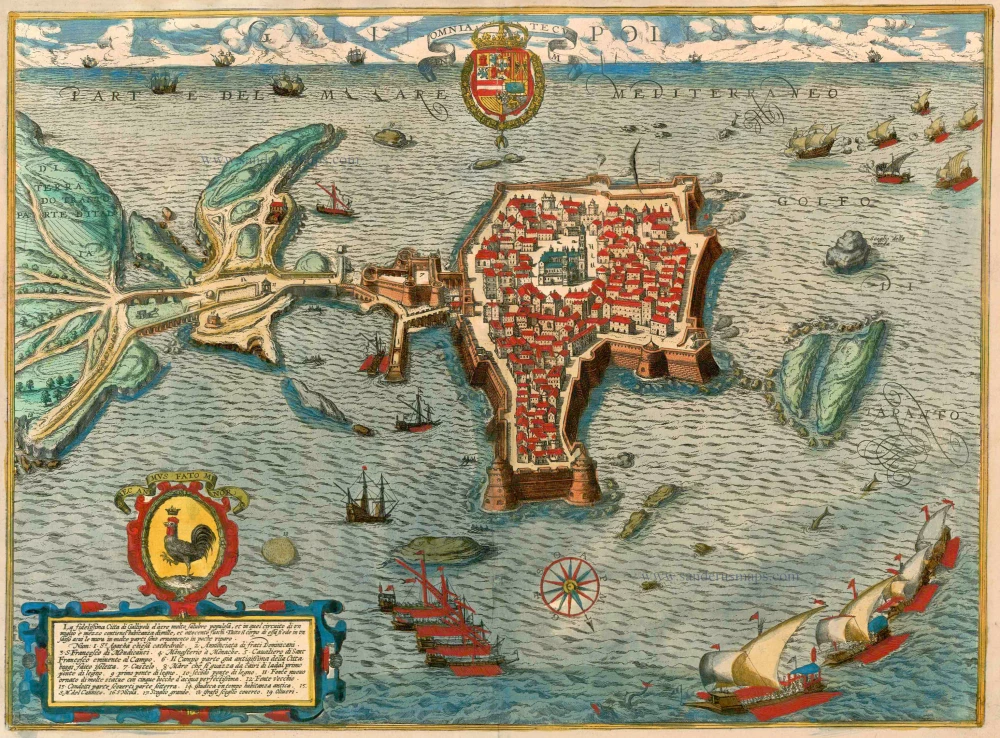


TRANSLATION OF CARTOUCHE TEXT: The most secure town of Gallipoli has very healthy air and is also very populous. It has 1,800 houses within a radius of just one and a half miles. The entire town lies on a rock, well protected by walls, which are also magnificent to look at due to their design.
COMMENTARY BY BRAUN (on verso): "Gallipoli lies on a rock and is connected to the mainland by a bridge. At the entrance to the city stands a well-fortified castle, which serves to protect and preserve the site. In addition to other churches, Gallipoli has a great cathedral dedicated to St Agatha. It also has a new fountain, which is decorated with artistic pictures and out of which good and healthy water flows from five pipes for the benefit of the populace. [...] The island that is divided in half by the sea and is here labelled as Number 6 was once part of the mainland but was severed from the city by the rough seas and has now become an island, which is dedicated to St Andrew."
The heavily fortified town of Gallipoli, which lies on a rocky island in the Gulf of Tarent south of Lecce, is presented in a bird's-eye view from the north. The maritime staffage (sailing boats, galleys and dolphins) emphasizes Gallipoli's role as a port near the southern tip of the Salentine Peninsula. At the entrance to the town, still on the mainland, stands the Fontana Hellenistica, or "Greek fountain" (Fonte Nuovo, 11), adorned with antique reliefs. Also worthy of mention are the citadel and the cathedral of Sant'Agata (1), replaced after 1629 by a new church in the Leccese Baroque style. Gallipoli's historical Old Town rises on the foundations of the Greek settlement of Kallipolis, whose name means "beautiful city". The small town in the Apulian province of Lecce has preserved this aura even today.
The view is made after a copper engraving by Natale Bonifacio di Girolamo (according to Skelton 1956), who was active in Rome and Venice c. 1580. The draughtsman was Giambattista Crispi.
Braun G. & Hogenberg F. and the Civitates Orbis Terrarum.
The Civitates Orbis Terrarum, or the "Braun & Hogenberg", is a six-volume town atlas and the most excellent book of town views and plans ever published: 363 engravings, sometimes beautifully coloured. It was one of the best-selling works in the last quarter of the 16th century. Georg Braun wrote the text accompanying the plans and views on the verso. Many plates were engraved after the original drawings of a professional artist, a professional artist, Joris Hoefnagel (1542-1600). The first volume was published in Latin in 1572, and the sixth in 1617. Frans Hogenberg created the tables for volumes I through IV, and Simon van den Neuwel made those for volumes V and VI. Other contributors were cartographers Daniel Freese and Heinrich Rantzau. Works by Jacob van Deventer, Sebastian Münster, and Johannes Stumpf were also used. Translations appeared in German and French.
Following the original publication of Volume 1 of the Civitates in 1572, seven further editions of 1575, 1577, 1582, 1588, 1593, 1599 and 1612 can be identified. Vol.2, first issued in 1575, was followed by further editions in 1597 and 1612. The subsequent volumes appeared in 1581, 1588, 1593, 1599 and 1606. The German translation of the first volume appeared from 1574 on, and the French edition from 1575 on.
Several printers were involved: Theodor Graminaeus, Heinrich von Aich, Gottfried von Kempen, Johannis Sinniger, Bertram Buchholtz and Peter von Brachel, who all worked in Cologne.
Georg Braun (1541-1622)
Georg Braun was born in Cologne in 1541. After his studies in Cologne, he entered the Jesuit Order as a novice. 1561, he obtained his bachelor's degree, and in 1562, he received his Magister Artium. Although he left the Jesuit Order, he studied theology, gaining a licentiate in theology.
Frans Hogenberg (1535-1590)
Frans Hogenberg was a Flemish and German painter, engraver, and mapmaker. He was born in Mechelen as the son of Nicolaas Hogenberg.
By the end of the 1560s, Frans Hogenberg was employed upon Abraham Ortelius's Theatrum Orbis Terrarum, published in 1570; he is named an engraver of numerous maps. In 1568, he was banned from Antwerp by the Duke of Alva and travelled to London, where he stayed a few years before emigrating to Cologne. He immediately embarked on his two most important works, the Civitates, published in 1572 and the Geschichtsblätter, which appeared in several series from 1569 until about 1587.
Thanks to large-scale projects like the Geschichtsblätter and the Civitates, Hogenberg's social circumstances improved with each passing year. He died as a wealthy man in Cologne in 1590.
Galli Polis / La fidelissima Citta di Gallipoli . . .
Item Number: 23403 Authenticity Guarantee
Category: Antique maps > Europe > Italy - Cities
Old, antique bird’s-eye view plan of Gallipoli, by Georg Braun & Frans Hogenberg.
Title: Galli Polis / La fidelissima Citta di Gallipoli . . .
Date of the first edition: 1596.
Date of this map: 1623.
Copper engraving, printed on paper.
Size (not including margins): 380 x 515mm (14.96 x 20.28 inches).
Verso: Latin text.
Condition: Excellent, superb old colour.
Condition Rating: A+.
References: Van der Krogt 4, 1431; Taschen, Braun and Hogenberg, p.425
From: Urbium Praeipuarum Mundi Theatrum Quintum Auctore Georgio Braunio Agrippinate. Part 5. Köln, Petrus von Brachel, 1623. (Van der Krogt 4, 41:1.5)
TRANSLATION OF CARTOUCHE TEXT: The most secure town of Gallipoli has very healthy air and is also very populous. It has 1,800 houses within a radius of just one and a half miles. The entire town lies on a rock, well protected by walls, which are also magnificent to look at due to their design.
COMMENTARY BY BRAUN (on verso): "Gallipoli lies on a rock and is connected to the mainland by a bridge. At the entrance to the city stands a well-fortified castle, which serves to protect and preserve the site. In addition to other churches, Gallipoli has a great cathedral dedicated to St Agatha. It also has a new fountain, which is decorated with artistic pictures and out of which good and healthy water flows from five pipes for the benefit of the populace. [...] The island that is divided in half by the sea and is here labelled as Number 6 was once part of the mainland but was severed from the city by the rough seas and has now become an island, which is dedicated to St Andrew."
The heavily fortified town of Gallipoli, which lies on a rocky island in the Gulf of Tarent south of Lecce, is presented in a bird's-eye view from the north. The maritime staffage (sailing boats, galleys and dolphins) emphasizes Gallipoli's role as a port near the southern tip of the Salentine Peninsula. At the entrance to the town, still on the mainland, stands the Fontana Hellenistica, or "Greek fountain" (Fonte Nuovo, 11), adorned with antique reliefs. Also worthy of mention are the citadel and the cathedral of Sant'Agata (1), replaced after 1629 by a new church in the Leccese Baroque style. Gallipoli's historical Old Town rises on the foundations of the Greek settlement of Kallipolis, whose name means "beautiful city". The small town in the Apulian province of Lecce has preserved this aura even today.
The view is made after a copper engraving by Natale Bonifacio di Girolamo (according to Skelton 1956), who was active in Rome and Venice c. 1580. The draughtsman was Giambattista Crispi.
Braun G. & Hogenberg F. and the Civitates Orbis Terrarum.
The Civitates Orbis Terrarum, or the "Braun & Hogenberg", is a six-volume town atlas and the most excellent book of town views and plans ever published: 363 engravings, sometimes beautifully coloured. It was one of the best-selling works in the last quarter of the 16th century. Georg Braun wrote the text accompanying the plans and views on the verso. Many plates were engraved after the original drawings of a professional artist, a professional artist, Joris Hoefnagel (1542-1600). The first volume was published in Latin in 1572, and the sixth in 1617. Frans Hogenberg created the tables for volumes I through IV, and Simon van den Neuwel made those for volumes V and VI. Other contributors were cartographers Daniel Freese and Heinrich Rantzau. Works by Jacob van Deventer, Sebastian Münster, and Johannes Stumpf were also used. Translations appeared in German and French.
Following the original publication of Volume 1 of the Civitates in 1572, seven further editions of 1575, 1577, 1582, 1588, 1593, 1599 and 1612 can be identified. Vol.2, first issued in 1575, was followed by further editions in 1597 and 1612. The subsequent volumes appeared in 1581, 1588, 1593, 1599 and 1606. The German translation of the first volume appeared from 1574 on, and the French edition from 1575 on.
Several printers were involved: Theodor Graminaeus, Heinrich von Aich, Gottfried von Kempen, Johannis Sinniger, Bertram Buchholtz and Peter von Brachel, who all worked in Cologne.
Georg Braun (1541-1622)
Georg Braun was born in Cologne in 1541. After his studies in Cologne, he entered the Jesuit Order as a novice. 1561, he obtained his bachelor's degree, and in 1562, he received his Magister Artium. Although he left the Jesuit Order, he studied theology, gaining a licentiate in theology.
Frans Hogenberg (1535-1590)
Frans Hogenberg was a Flemish and German painter, engraver, and mapmaker. He was born in Mechelen as the son of Nicolaas Hogenberg.
By the end of the 1560s, Frans Hogenberg was employed upon Abraham Ortelius's Theatrum Orbis Terrarum, published in 1570; he is named an engraver of numerous maps. In 1568, he was banned from Antwerp by the Duke of Alva and travelled to London, where he stayed a few years before emigrating to Cologne. He immediately embarked on his two most important works, the Civitates, published in 1572 and the Geschichtsblätter, which appeared in several series from 1569 until about 1587.
Thanks to large-scale projects like the Geschichtsblätter and the Civitates, Hogenberg's social circumstances improved with each passing year. He died as a wealthy man in Cologne in 1590.
Related items
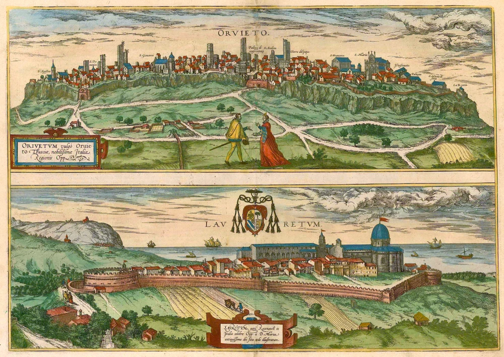
Orvieto [on sheet with] with Lauretum 1581-88
Orvieto - Lauretum, by Braun & Hogenberg.
[Item number: 2673]
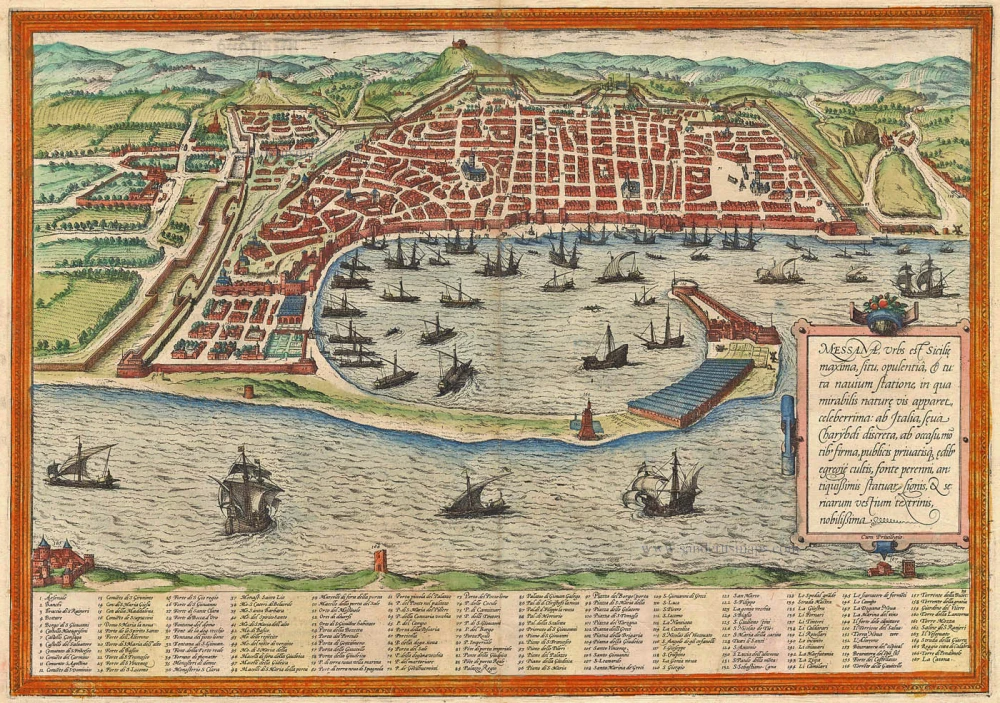
Messana, Urbs est Sicilie maxima, situ, opulentia, & tuta navium statione, ... 1574
Messina by Braun & Hogenberg
[Item number: 5497]
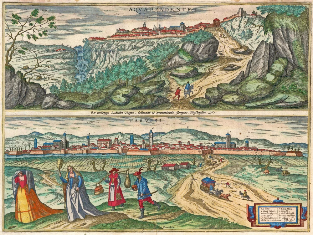
Aquapendente [on sheet with] Tarvisi c. 1610
Acquapendente and Tarvisio by Braun and Hogenberg.
[Item number: 14608]
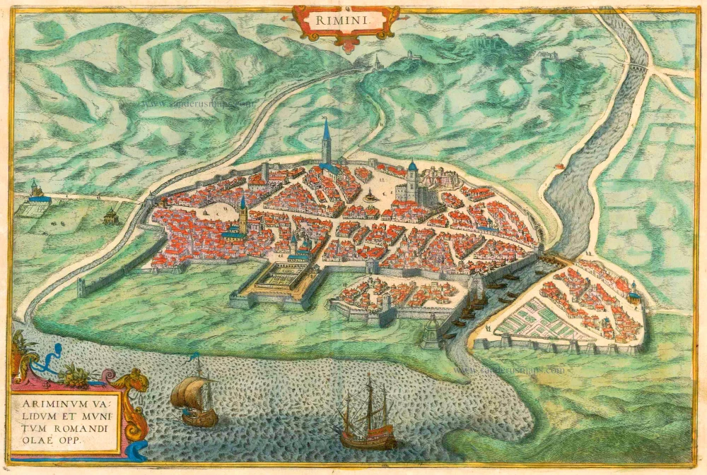
Rimini - Ariminum validum et munitum romandi olae opp. 1612
Rimini, by Braun & Hogenberg.
[Item number: 16426]
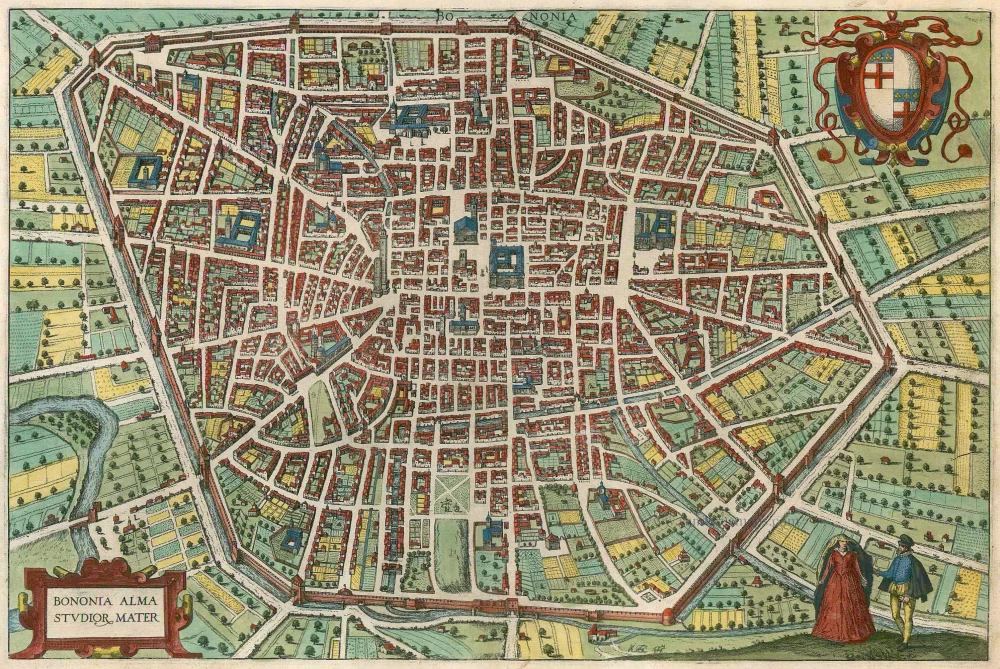
Bononia Alma Studior Mater 1588-97
Bologna by Braun and Hogenberg.
[Item number: 22602]

Vetustiss. Ad Mare Thyrrhenum Terracinae Oppidum 1623
Terracina by Braun and Hogenberg after G. Hoefnagel.
[Item number: 23334]