
Bressanone (Brixen) & Lauingen, by Georg Braun and Frans Hogenberg. c. 1593
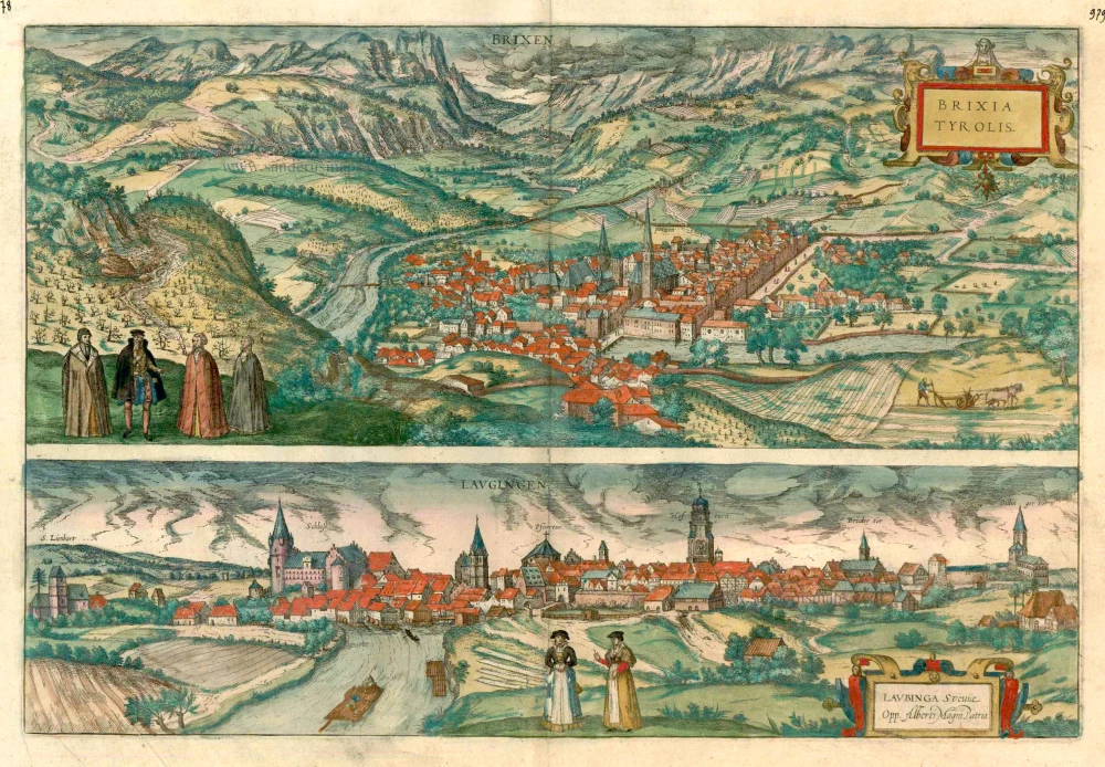


BRESSANONE
COMMENTARY BY BRAUN: "High mountains surround the countryside of Bressanone, and there are many splendid fruit trees and other things here, notably white and red wine, so excellent that it is bought at a high price and exported to distant countries, where it is often drunk at princely tables and is reserved for banquets of state. The city boasts a magnificent episcopal cathedral, a collegiate church, and an ancient episcopal palace."
Bressanone (in German Brixen), situated in a valley at the confluence of the Rienza and the Isarco, is seen from a mountain vantage point west-southwest of the city. The wide bridge spanning the Isarco leads to the parish church of St Michael with its pointed spire in the east abutting the chancel. To the left of it is the smaller 12th-century cathedral. The importance of the city's location at the head of the Brenner Pass is underscored by the inscription Roads from Potzen (Bolzano). Made an episcopal see in AD 990, Bressanone became the self-governing seat of prince-bishops in the 11th century. In 1150 Bressanone was fortified with walls, and the transit traffic flourishing on the Brenner route made its citizens prosper.
LAUINGEN
CARTOUCHE: Lauingen in Swabia, the birthplace of Albertus Magnus.
COMMENTARY BY BRAUN: "Lauingen is an old town on the Danube belonging to the Bavarian princes is Swabia, which can be seen not only in the design of its houses but can be read from its many Latin inscriptions. This city is the birthplace of Albertus Magnus, who descended from the illustrious Sollstetter family. On the site of his birthplace or house, a handsome church has been built, on the tower of which the inhabitants have placed his likeness to commemorate him."
This view from the east shows Lauingen, known for its artisans, as the figures in the foreground indicate. The bolts of cloth laid out to bleach on the meadows allude to the craft of weaving, which was an essential source of income for the town. Erected as a watchtower in the 15th century, the Schimmel tower (Hofturn) dwarfs the city. To the left is the late Gothic hall church of St Martin. The Spitalkirche (Hospice Church) by the Danube, whose late Gothic tower is visible to the right of the 15th-century castle, dates from the 13th century. The Dukes of Bavaria-Landshut built it. Lauingen, which was first mentioned in the 8th century, is now a small town in the rural district of Dillingen. (Taschen)
Braun G. & Hogenberg F. and the Civitates Orbis Terrarum.
The Civitates Orbis Terrarum, or the "Braun & Hogenberg", is a six-volume town atlas and the most excellent book of town views and plans ever published: 363 engravings, sometimes beautifully coloured. It was one of the best-selling works in the last quarter of the 16th century. Georg Braun wrote the text accompanying the plans and views on the verso. Many plates were engraved after the original drawings of a professional artist, a professional artist, Joris Hoefnagel (1542-1600). The first volume was published in Latin in 1572, and the sixth in 1617. Frans Hogenberg created the tables for volumes I through IV, and Simon van den Neuwel made those for volumes V and VI. Other contributors were cartographers Daniel Freese and Heinrich Rantzau. Works by Jacob van Deventer, Sebastian Münster, and Johannes Stumpf were also used. Translations appeared in German and French.
Following the original publication of Volume 1 of the Civitates in 1572, seven further editions of 1575, 1577, 1582, 1588, 1593, 1599 and 1612 can be identified. Vol.2, first issued in 1575, was followed by further editions in 1597 and 1612. The subsequent volumes appeared in 1581, 1588, 1593, 1599 and 1606. The German translation of the first volume appeared from 1574 on, and the French edition from 1575 on.
Several printers were involved: Theodor Graminaeus, Heinrich von Aich, Gottfried von Kempen, Johannis Sinniger, Bertram Buchholtz and Peter von Brachel, who all worked in Cologne.
Georg Braun (1541-1622)
Georg Braun was born in Cologne in 1541. After his studies in Cologne, he entered the Jesuit Order as a novice. 1561, he obtained his bachelor's degree, and in 1562, he received his Magister Artium. Although he left the Jesuit Order, he studied theology, gaining a licentiate in theology.
Frans Hogenberg (1535-1590)
Frans Hogenberg was a Flemish and German painter, engraver, and mapmaker. He was born in Mechelen as the son of Nicolaas Hogenberg.
By the end of the 1560s, Frans Hogenberg was employed upon Abraham Ortelius's Theatrum Orbis Terrarum, published in 1570; he is named an engraver of numerous maps. In 1568, he was banned from Antwerp by the Duke of Alva and travelled to London, where he stayed a few years before emigrating to Cologne. He immediately embarked on his two most important works, the Civitates, published in 1572 and the Geschichtsblätter, which appeared in several series from 1569 until about 1587.
Thanks to large-scale projects like the Geschichtsblätter and the Civitates, Hogenberg's social circumstances improved with each passing year. He died as a wealthy man in Cologne in 1590.
Brixen - Brixia Tyrolis [on sheet with] Laugingen - Laubinga Sueviae Opp. Alberti Magni Patria.
Item Number: 24575 Authenticity Guarantee
Category: Antique maps > Europe > Italy - Cities
Old, antique map with two birds-eye views of Bressanone (Brixen) in South Tirol, Italy and Lauingen (Schwaben - Germany), by Georg Braun and Frans Hogenberg.
Title: Brixen - Brixia Tyrolis [on sheet with] Laugingen - Laubinga Sueviae Opp. Alberti Magni Patria.
Date of the first edition: 1588.
Date of this map: c. 1593.
Copper engraving, printed on paper.
Size (not including margins): 333 x 493mm (13.11 x 19.41 inches).
Verso: French text.
Condition: Original coloured, excellent.
Condition Rating: A+.
From: Liber Quartus - Livre Quatriesme des Principales Villes du Monde, 1593. (Van der Krogt 4, 41:3.4(1593))
BRESSANONE
COMMENTARY BY BRAUN: "High mountains surround the countryside of Bressanone, and there are many splendid fruit trees and other things here, notably white and red wine, so excellent that it is bought at a high price and exported to distant countries, where it is often drunk at princely tables and is reserved for banquets of state. The city boasts a magnificent episcopal cathedral, a collegiate church, and an ancient episcopal palace."
Bressanone (in German Brixen), situated in a valley at the confluence of the Rienza and the Isarco, is seen from a mountain vantage point west-southwest of the city. The wide bridge spanning the Isarco leads to the parish church of St Michael with its pointed spire in the east abutting the chancel. To the left of it is the smaller 12th-century cathedral. The importance of the city's location at the head of the Brenner Pass is underscored by the inscription Roads from Potzen (Bolzano). Made an episcopal see in AD 990, Bressanone became the self-governing seat of prince-bishops in the 11th century. In 1150 Bressanone was fortified with walls, and the transit traffic flourishing on the Brenner route made its citizens prosper.
LAUINGEN
CARTOUCHE: Lauingen in Swabia, the birthplace of Albertus Magnus.
COMMENTARY BY BRAUN: "Lauingen is an old town on the Danube belonging to the Bavarian princes is Swabia, which can be seen not only in the design of its houses but can be read from its many Latin inscriptions. This city is the birthplace of Albertus Magnus, who descended from the illustrious Sollstetter family. On the site of his birthplace or house, a handsome church has been built, on the tower of which the inhabitants have placed his likeness to commemorate him."
This view from the east shows Lauingen, known for its artisans, as the figures in the foreground indicate. The bolts of cloth laid out to bleach on the meadows allude to the craft of weaving, which was an essential source of income for the town. Erected as a watchtower in the 15th century, the Schimmel tower (Hofturn) dwarfs the city. To the left is the late Gothic hall church of St Martin. The Spitalkirche (Hospice Church) by the Danube, whose late Gothic tower is visible to the right of the 15th-century castle, dates from the 13th century. The Dukes of Bavaria-Landshut built it. Lauingen, which was first mentioned in the 8th century, is now a small town in the rural district of Dillingen. (Taschen)
Braun G. & Hogenberg F. and the Civitates Orbis Terrarum.
The Civitates Orbis Terrarum, or the "Braun & Hogenberg", is a six-volume town atlas and the most excellent book of town views and plans ever published: 363 engravings, sometimes beautifully coloured. It was one of the best-selling works in the last quarter of the 16th century. Georg Braun wrote the text accompanying the plans and views on the verso. Many plates were engraved after the original drawings of a professional artist, a professional artist, Joris Hoefnagel (1542-1600). The first volume was published in Latin in 1572, and the sixth in 1617. Frans Hogenberg created the tables for volumes I through IV, and Simon van den Neuwel made those for volumes V and VI. Other contributors were cartographers Daniel Freese and Heinrich Rantzau. Works by Jacob van Deventer, Sebastian Münster, and Johannes Stumpf were also used. Translations appeared in German and French.
Following the original publication of Volume 1 of the Civitates in 1572, seven further editions of 1575, 1577, 1582, 1588, 1593, 1599 and 1612 can be identified. Vol.2, first issued in 1575, was followed by further editions in 1597 and 1612. The subsequent volumes appeared in 1581, 1588, 1593, 1599 and 1606. The German translation of the first volume appeared from 1574 on, and the French edition from 1575 on.
Several printers were involved: Theodor Graminaeus, Heinrich von Aich, Gottfried von Kempen, Johannis Sinniger, Bertram Buchholtz and Peter von Brachel, who all worked in Cologne.
Georg Braun (1541-1622)
Georg Braun was born in Cologne in 1541. After his studies in Cologne, he entered the Jesuit Order as a novice. 1561, he obtained his bachelor's degree, and in 1562, he received his Magister Artium. Although he left the Jesuit Order, he studied theology, gaining a licentiate in theology.
Frans Hogenberg (1535-1590)
Frans Hogenberg was a Flemish and German painter, engraver, and mapmaker. He was born in Mechelen as the son of Nicolaas Hogenberg.
By the end of the 1560s, Frans Hogenberg was employed upon Abraham Ortelius's Theatrum Orbis Terrarum, published in 1570; he is named an engraver of numerous maps. In 1568, he was banned from Antwerp by the Duke of Alva and travelled to London, where he stayed a few years before emigrating to Cologne. He immediately embarked on his two most important works, the Civitates, published in 1572 and the Geschichtsblätter, which appeared in several series from 1569 until about 1587.
Thanks to large-scale projects like the Geschichtsblätter and the Civitates, Hogenberg's social circumstances improved with each passing year. He died as a wealthy man in Cologne in 1590.
Related items
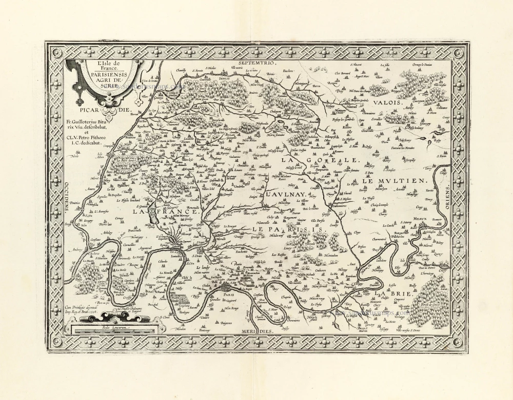
L'Ile de France. Parisiensis Agri Descrip. 1612
Ile de France by Ortelius A.
[Item number: 23050]
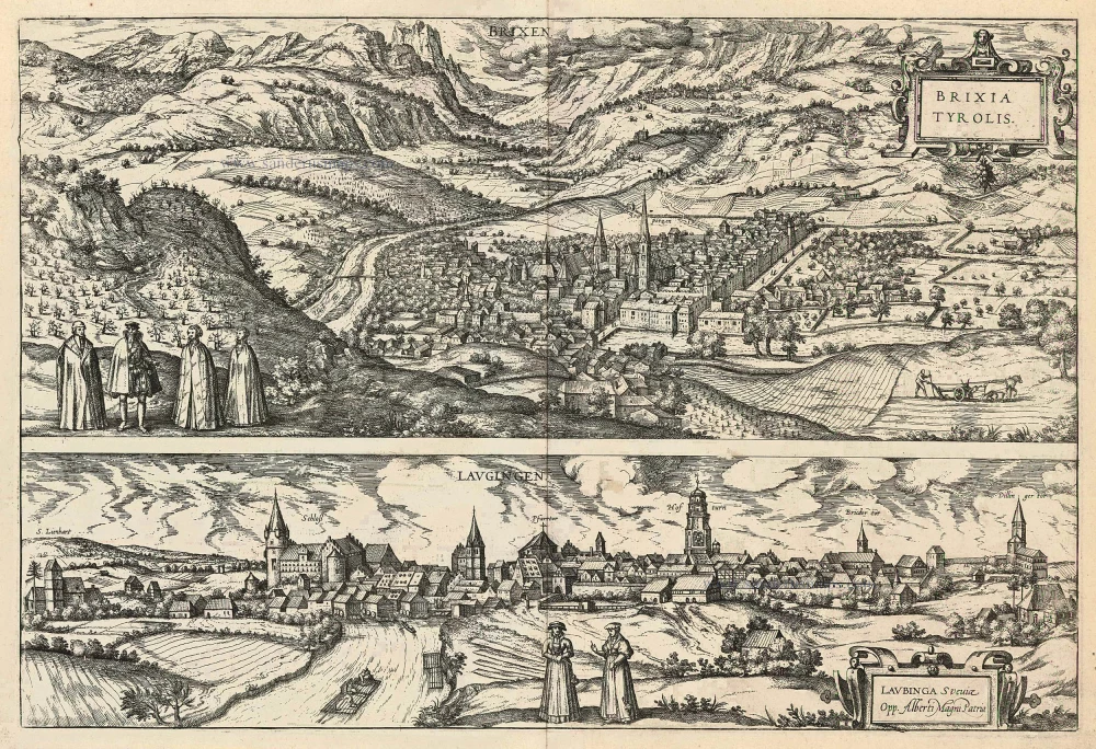
Brixen - Brixia Tyrolis [on sheet with] Laugingen - Laubinga Sueviae Opp. Alberti Magni Patria. 1599
Bressanone (Brixen) in South Tyrol Italy and Lauingen in Schwaben Germany, by Georg Braun and Frans Hogenberg.
[Item number: 24119]